Good Thursday, folks. Hurricane Helene is heading toward a Florida landfall later today before heading toward Kentucky on Friday. What’s left of this storm is set to bring flooding rains and high winds. Those high winds may cause some damage.
Let’s start things out by talking about Helene then I’ll break down the impacts on our weather.
Helene is a massive storm in terms of coverage and is continuing to intensify. Here’s the current satellite shot of the storm…

Helene will become a category 4 hurricane before making landfall late this evening near Apalachicola, Florida. From there, this zips northward across Georgia and into Tennessee by Friday morning. From there, the center crosses into southern Kentucky and then stalls across western Kentucky into Friday night.
Here’s the latest information and track forecast from the National Hurricane Center…

This storm is forecast to bring a life-threatening storm surge up to 20 feet for part of Apalachee bay…
![[Image of cumulative wind history]](https://www.nhc.noaa.gov/storm_graphics/AT09/refresh/AL092024_peak_surge+png/213335_peak_surge.png)
Here’s a breakdown of what I expect from Helene here in Kentucky:
TODAY
- Waves of showers and storms impact the eastern half of the state through early afternoon.
- Heavy rain may cause local high water concerns in these areas.
- Rain and some thunder then starts to develop west across the state this afternoon.
TONIGHT
- Heavy rains will become more common across the entire region.
- This will come in waves spiraling from east/northeast to west/southwest.
- Some local high water issues may develop during this time.
- Winds start to gust and may reach 35mph by morning.
FRIDAY
- HIGH WINDS THREAT AND FLASH FLOOD THREAT
- Waves of torrential rain producing showers and some thunderstorms spin across the state.
- Rainfall of 2″-4″ will be possible in much of the state just during this time period.
- Flash flooding is a good bet for some areas.
- High winds are going to be a major player. Gusts of 50mph to 60mph will be possible. I can’t rule out a few gusts exceeding 60mph.
- Power outages and some wind damage are likely.
- I’m also watching central and eastern Kentucky for a low-end risk for a tornado spin up.
FRIDAY NIGHT
- Additional waves of heavy rain spin across western and central Kentucky.
- This action expands to the east during the overnight.
- Additional flash flooding and general flooding is possible.
- Winds come way down but gusts of 30-40mph will be a good bet.
SATURDAY
- What’s left of Helene slowly spins eastward across Kentucky.
- Rounds of heavy rain continue and may drop another 1″-3″ in some areas.
- Once again, flash flooding and general flooding are a real possibility.
SATURDAY NIGHT/SUNDAY
- Our system continues to weaken as it slowly pushes to the east.
- Leftover showers continue to spin across central and eastern Kentucky.
- High water may still be a concern.
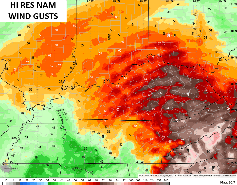
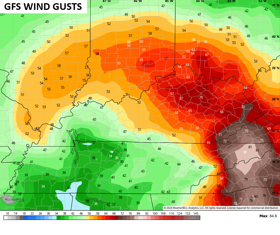
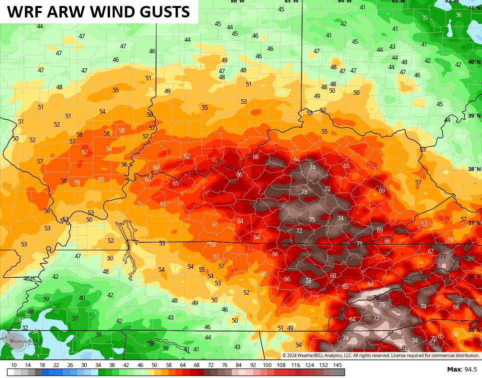
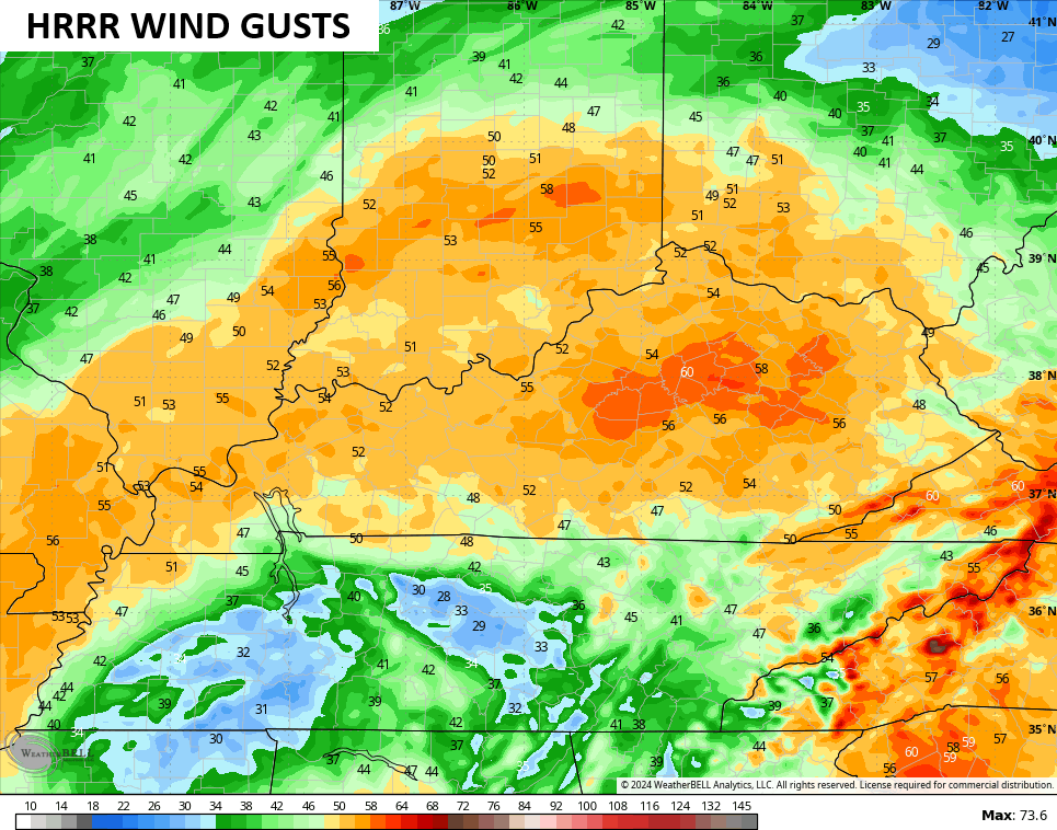
In terms of the HIGH WIND THREAT, the models are all locked in on a significant wind event across much of the state, but there’s more of a bullseye on central and eastern Kentucky than the west.
The Hi Res NAM continues to be off the charts with hurricane force wind gusts…
It now has a few partners in the GFS and WRF which are also showing gusts pushing hurricane force…
The HRRR is right at 60mph…
So too is the NAM…
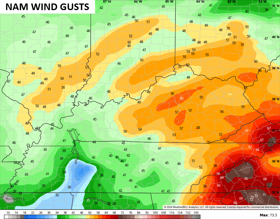
The EURO has some 60-65mph gusts showing up…
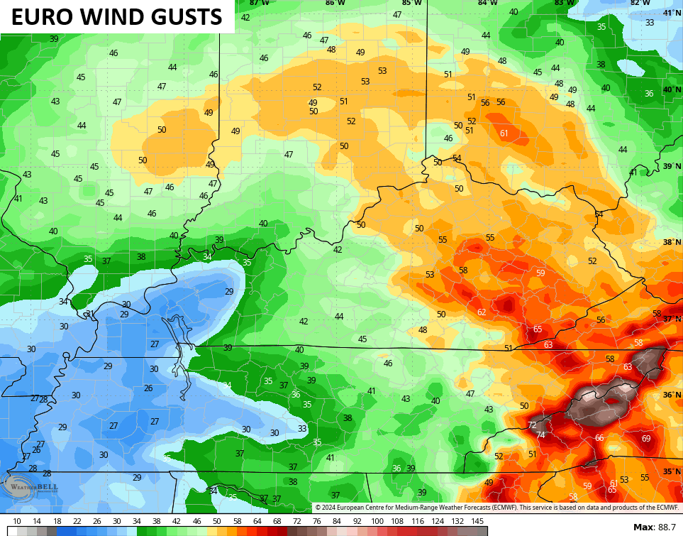
All of those models are well into the High Wind Warning criteria for much of central and eastern Kentucky. With leaves on the trees and a soggy ground, watch out, a lot of trees may come down.
Those are the kind of winds one would expect with such a potent storm system. The GFS is forecasting this low to be at 979 millibars as it enters southern Kentucky Friday morning…
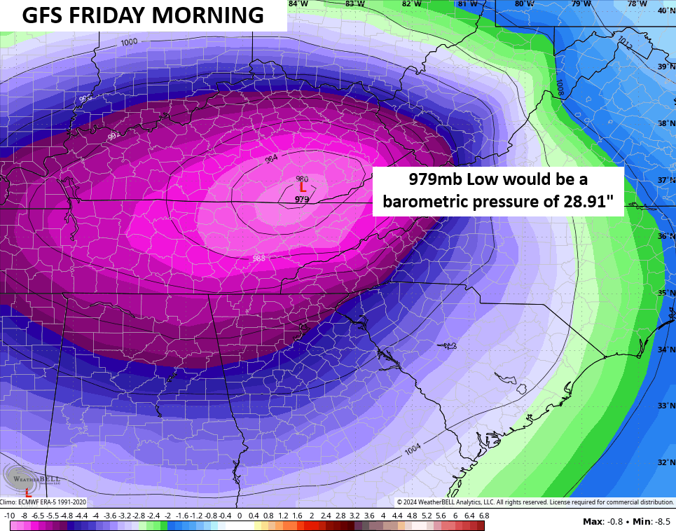
As you can see, that would equal out at 28.91″ on the barometer. For perspective’s sake and to show how we are in rare air, Lexington’s all time record low barometric pressure is 28.82″ during the January blizzard of 1978. Our pressure has only dropped below 29″ on 3 occasions, including the March 3, 2023 windstorm.
For the FLOOD THREAT part of the storm, my concern is the models are underestimating rainfall totals. This is something that’s common with landfalling tropical systems, so let’s keep this in mind going forward.
All the models are increasing rainfall numbers as we get closer to this setup. The GFS is now showing many areas with 5″-6″ over the next few days…
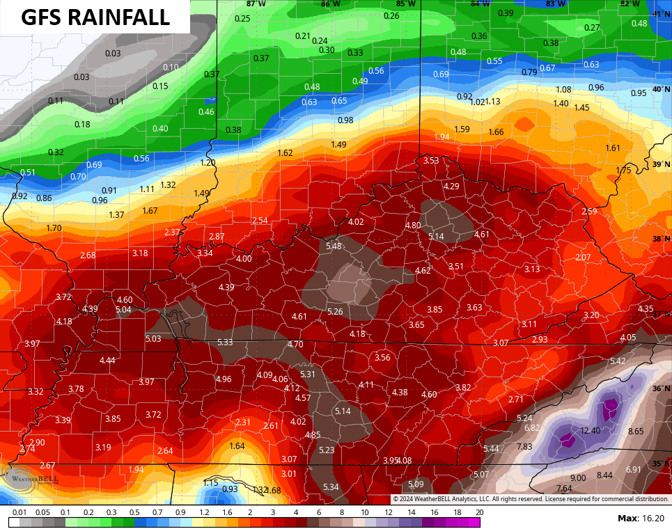
This is something the Canadian has been locked in on for a while and it continues to spit out these kinds of numbers…
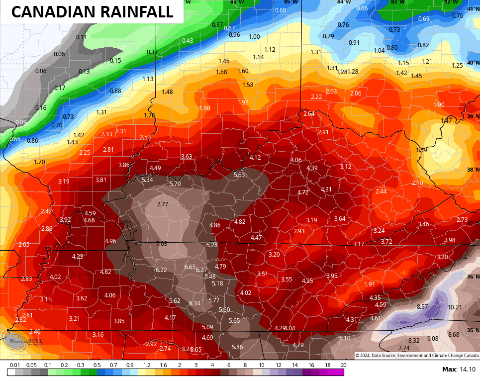
The EURO has some 5″+ amounts…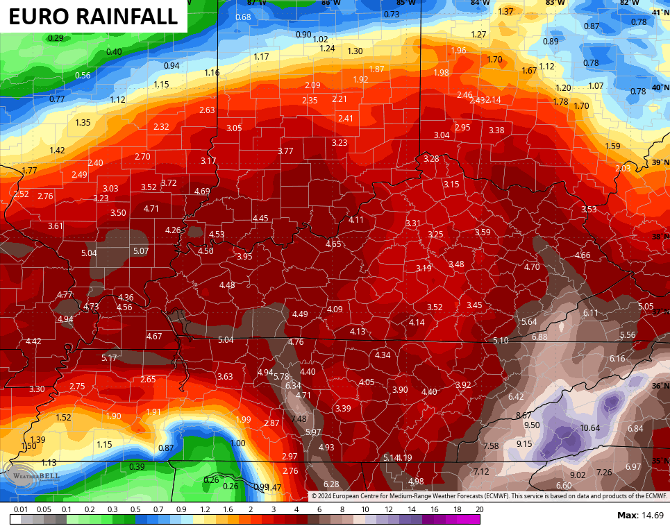
The NAM only goes through Saturday night but it’s also seeing the potential for some 5″-6″ rain amounts…
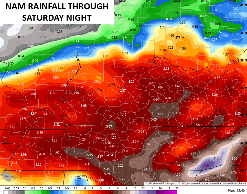
The potential for significant flooding is there through Saturday night. Please stay aware of this increasing threat.
We aren’t alone in dealing with the threat for flooding. Areas in the southern Appalachian Mountains may experience historic and devastating floods. This map from the NOAA shows the areas at risk…
![[Image of WPC Flash Flooding/Excessive Rainfall Outlook]](https://www.nhc.noaa.gov/storm_graphics/AT09/refresh/AL0924WPCERO+gif/213335WPCERO_sm.gif)
I will have the very latest on WKYT News starting at 4pm and I’ll swing by for another update later this evening. Until then, here are your Wednesday tracking tools…


Have a great Thursday and take care.

Too much of a good thing coming.
Jeff, That’s exactly right ” too much of a good thing. “
Thanks Chris. Those Winds look like a lot of structural damage and power failures, especially in rual areas like mine. Great, and a very well detailed Blog this morning. Your forecast over the last two weeks have been right on. I guess this is Mother Natures way, the equal and opposite reaction.
Be Safe Everyone !
The combination of heavy rains saturating the ground and near hurricane wind gusts means that the danger from uprooted trees will be high, and that will seriously impact our power distribution grid. During the December 2021 tornado outbreak, trees and large limbs fell on power lines, and in many cases the same lines were broken in several places, which caused repair work to stretch into weeks. Be prepared to see serious power disruptions.
I hope that doesn’t happen Joe, as we are always the last to have our power restored.