Good Friday, everyone. Today is a wild day across Kentucky as what’s left of once powerful Hurricane Helene rolls into the Commonwealth. This brings high winds and the potential for flooding and flash flooding that lasts into the weekend.
Let’s get straight to the latest on Helene from the National Hurricane Center…

This is one of the fastest moving tropical systems that you will ever see. It made landfall around 11pm last night near the big bend area of Florida and the center of circulation works into Kentucky by early this afternoon. That’s around 500 miles in a little more than 12 hours, but that’s what happens with an upper low essentially slinging this system around it before merging with it later today.
Before we get to the models, let me give you a fresh breakdown:
TODAY
- Helene moves into southern Kentucky by early this afternoon and is likely to still be a Tropical Depression. There’s a chance it’s still classified as a Tropical Storm.
- Widespread high winds will be noted across the state with the core of the highest winds showing up just north and east of the track of the low.
- The area from southeastern Kentucky through the Lexington metro and north is likely to feel the core of the winds. 50-60mph gusts show up with the potential for 60mph+ at times.
- The rest of the state should see gusts of 40mph+.
- Waves of wind-driven heavy rain spin across the state, likely causing high water issues.
- A general 2″-4″ of rain show through early evening. This will lead to flash flooding concerns.
- Areas of eastern and southeastern Kentucky will see lower totals than your neighbors to the west and you folks may see some late day sun.
- There is still the lowest chance for one of these bands to spin up something today.
TONIGHT
- The center of Helene spins slowly across western Kentucky. This will likely be nearly stationary.
- Winds continue to come down with gusts of 30mph-40mph possible.
- Heavy rain bands spin across western and central Kentucky with only a few showers in the east.
- Flooding concerns continue for the west and central parts of the state, especially.
SATURDAY
- The center continues to spin in nearly the same areas of western Kentucky.
- Winds are gusting to 30mph from time to time.
- Heavy rain bands continue to show up for much of the state.
- Another 1″-3″ of rain will be possible across central and western Kentucky. This is where more flooding will be possible.
SUNDAY
- Our low continues to slowly weaken as it moves a bit farther east.
- Rains won’t be as heavy, but some pretty good showers will still show up.
Let’s start things out with what I’m currently expecting with the flood threat. Areas of central, northern and western Kentucky have the Greatest Risk for flooding with rainfall totals through Saturday in the 3″-6″ range with locally higher amounts…
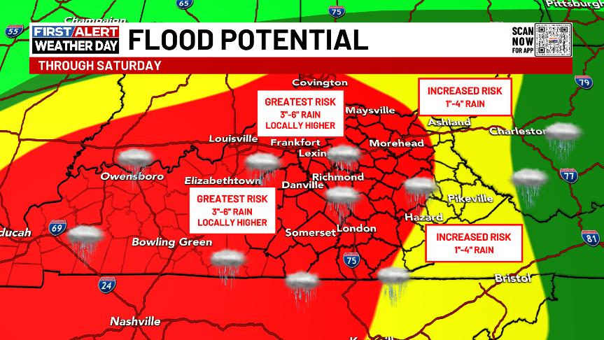
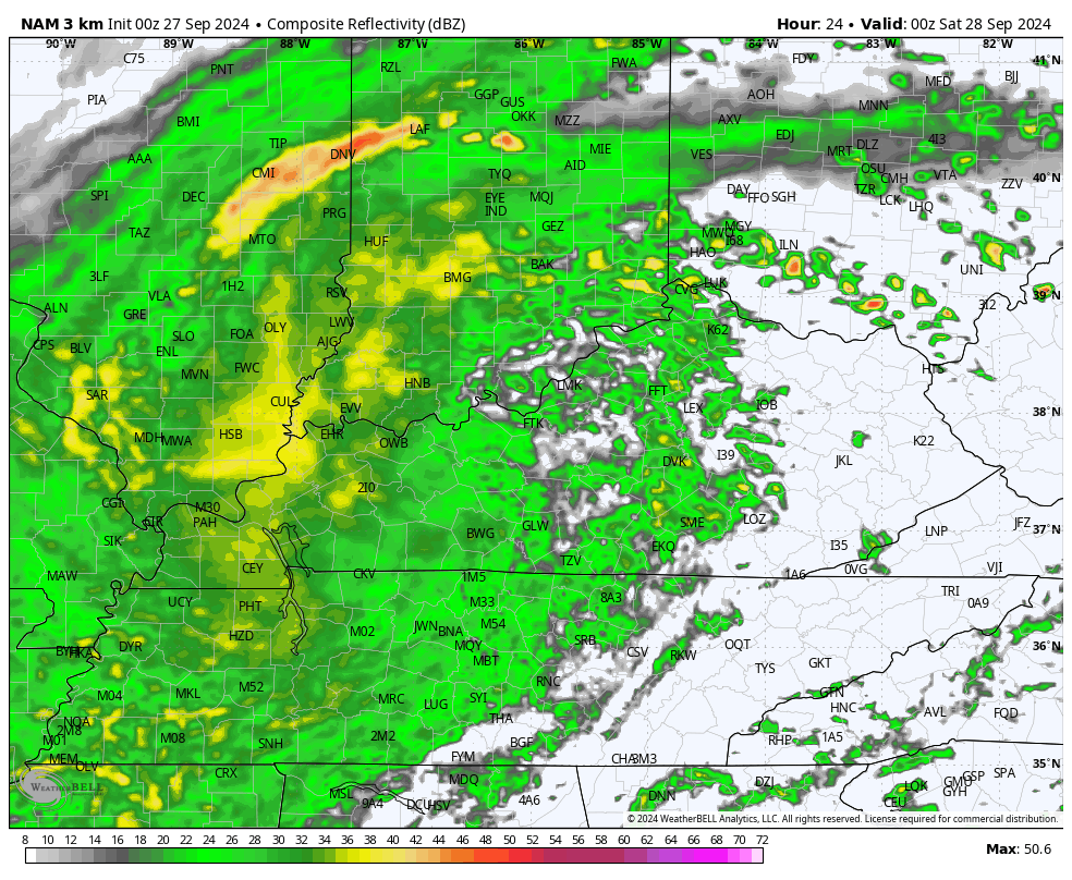
Again, this isn’t just what falls today, but also includes the spiraling bands tonight and into Saturday. The Future Radar from the Hi Res NAM starts at 8pm this evening and goes through Saturday night…
The models are all forecasting some very hefty rain totals across our region…
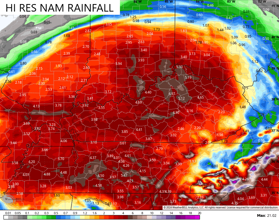
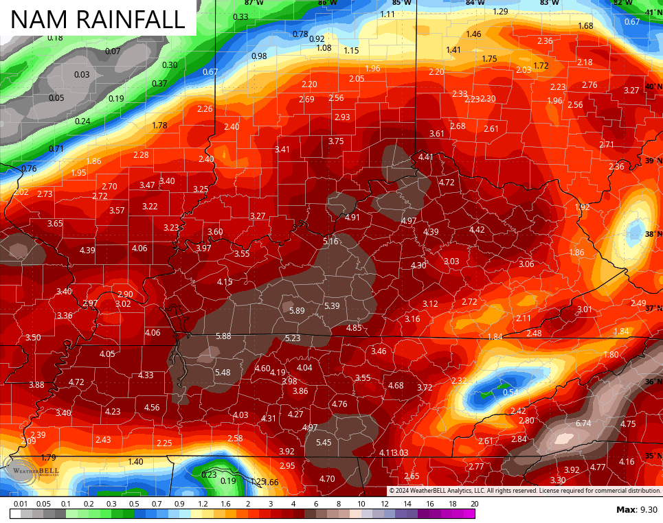
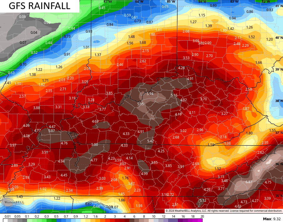
I’m still worried these models are on the low side, especially across central and western Kentucky.
Here’s the current Flash Flood Risk outlook from NOAA…
![[Image of WPC Flash Flooding/Excessive Rainfall Outlook]](https://www.nhc.noaa.gov/storm_graphics/AT09/refresh/AL0924WPCERO+gif/213335WPCERO_sm.gif)
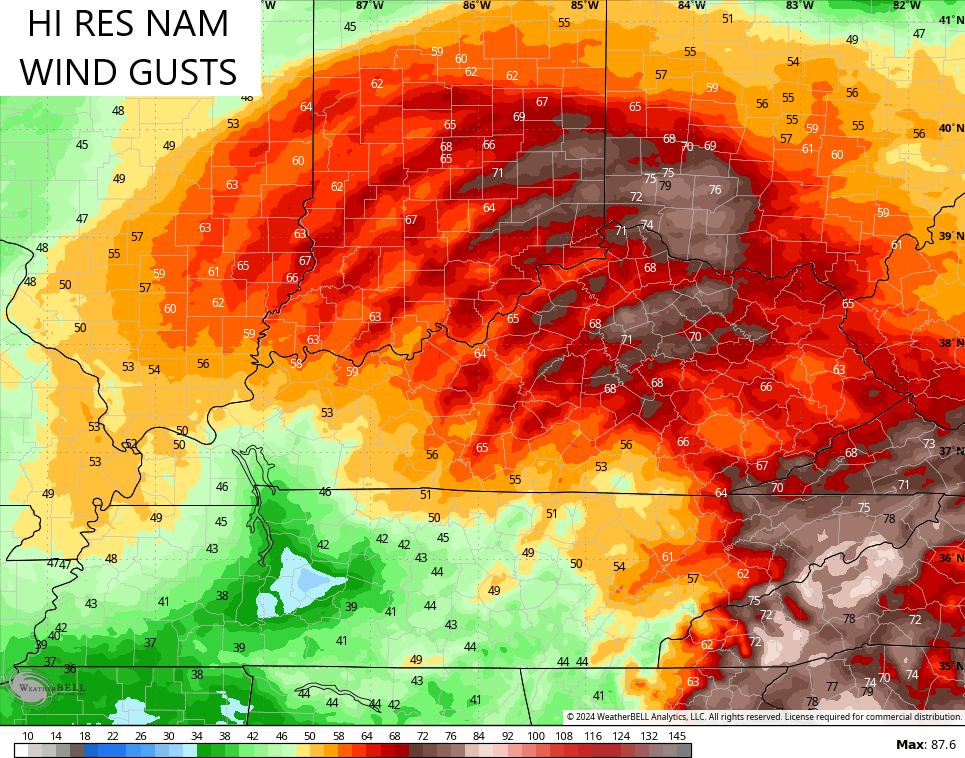
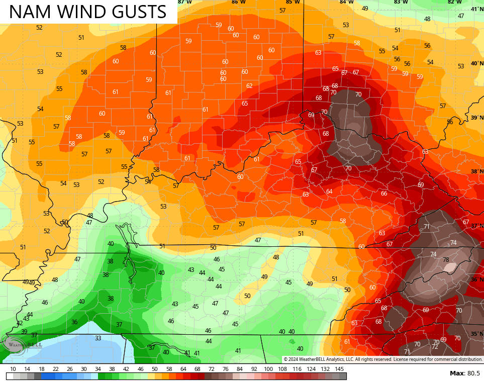
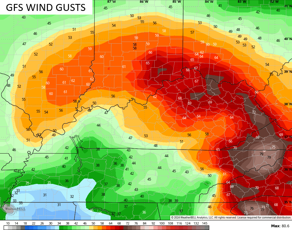
The models really aren’t blinking on the potential for significant winds that are greater than what I’m currently thinking.
Gusts of 70mph for Friday show up on the Hi Res NAM, NAM and GFS…
Today is a significant event, folks. Please stay weather aware and take all necessary precautions to stay safe.
I will be on WKYT for much of the day, likely starting around Noon or so. I’ll also drop by for another update this evening.
As always, I have you guys all set to track today’s high winds and heavy rains…


Stay safe and take care.

Just looking at the radar… It reminds of the Feb 1998 storm… Widespread heavy precip moving east to west…
anyway… it’s so nice to see everyone getting rain… and not just being “lucky” if you get under random storms
Hopefully it doesn’t get too crazy with the wind/rain
We’ve picked up 1.95 inches of rain since midnight in Central Warren County. Over the same stretch of time, the barometer continues to fall from a high of 29.90 in/hg at midnight, to its current value of 29.24 in/hg. Max wind gust so far has been 32mph. Our weather continues to be all or nothing, but the good news is that the rainfall will result in sizeable changes to this map:
https://www.facebook.com/photo.php?fbid=916177670533643&set=a.259975099487240&type=3&ref=embed_page
OK I just learned something from reading the NOAA forecast discussion just now… I had noticed on the east Ky radar how it looked like really super light precip in a section of SE KY but as it continues moving west, the precip intensifies ..
Rain Shadow
An area of reduced precipitation on the lee side of a mountain barrier caused by warming of air and dissipation of cloudiness as air descends the barrier.
That’s exactly right, Mark. Rain rates from Tropical systems can vary significantly based on the terrain they traverse. It’s one reason why some of the highest rain totals from Helene are forecasted to fall in the mountains of western North Carolina. Also, the influence of that upper level low increases as the storm move west, pulling up increasing amounts of tropical moisture.
Great Observation Mark.
1.24” since midnight. Stout wind, gusting enough to bring down big limbs (dog needed his morning constitutional so we surveyed the neighborhood and got drenched to the bone). We’re currently running on generator-energized circuits. KU says they are unable to keep up with the increasing number of reported outages. Glad the temps have moderated.
Thanks Chris. A very interesting, and unfortunately a deadly and destructive Hurricane Helene. I’m concerned about my older Sister and Brother in Law who are visiting here now, and plan to leave Sunday for Southwest Florida. I can’t imagine the mess they will have to go through on the way home.
We had about 1.80 inches since midnight. A very welcome all day rain, which I haven’t seen in years. A slow and steady rain too. Now, I’m ready for that nice cool Autumn weather with frosty mornings, and colorful Fall foliage.
Enjoy and be Safe Everyone !