Good Tuesday, everyone. It’s another awesome fall weather day here in Kentucky as the eyes of the weather world continue to turn toward the Gulf of Mexico. That’s where one of the strongest hurricanes ever recorded is as Milton is still targeting Florida.
Before we get there, let’s talk about Kentucky’s weather this week.
highs are generally in the upper 60s and low 70s through Friday. Overnight lows are in the 40-45 degree range, but some mid and upper 30s can show up, especially Friday morning.
Our weather is dry and calm, so enjoy it.
Hurricane Milton became one of the top 5 strongest hurricanes on record Monday afternoon. Winds hit 180mph as the pressure dropped to 897mb in what was truly a WOW day. Here’s what this system looks like on Satellite…

Hurricane Warnings are out for much of Florida with an expected landfall near Tampa Wednesday night. Here’s the latest information and track forecast from the National Hurricane Center…

The latest storm surge forecast shows the potential for a 15 foot surge for some areas…
![[Image of cumulative wind history]](https://www.nhc.noaa.gov/storm_graphics/AT14/refresh/AL142024_peak_surge+png/152801_peak_surge.png)
This will be a devastating hurricane for much of Florida.
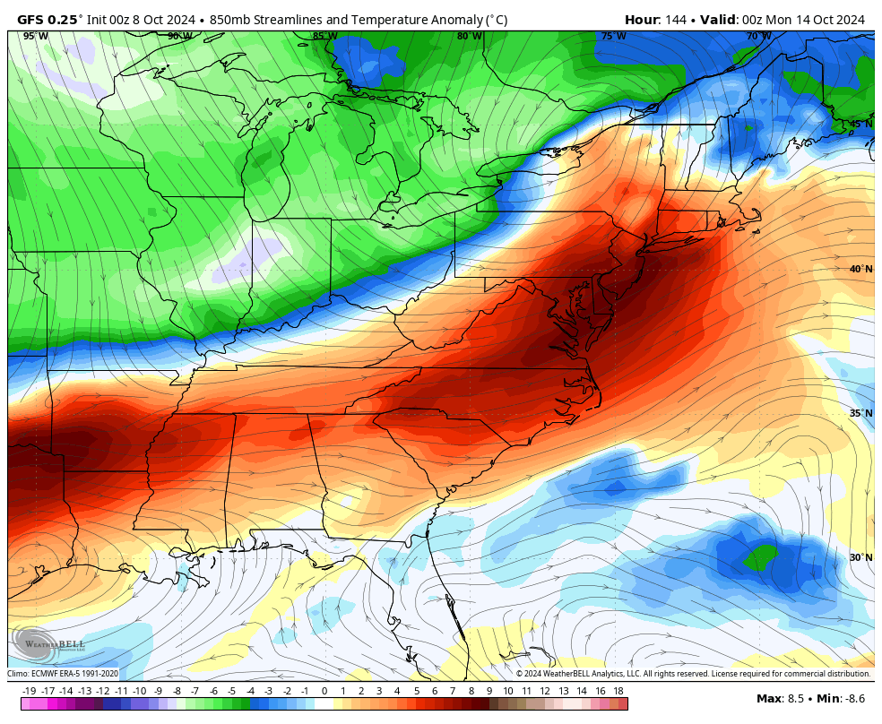
Back here in Kentucky, there’s another big time fall cold front rolling in here late Sunday into Sunday night with a big blast of cold air coming in behind it. Barney shows up early next week…
GFS
EURO
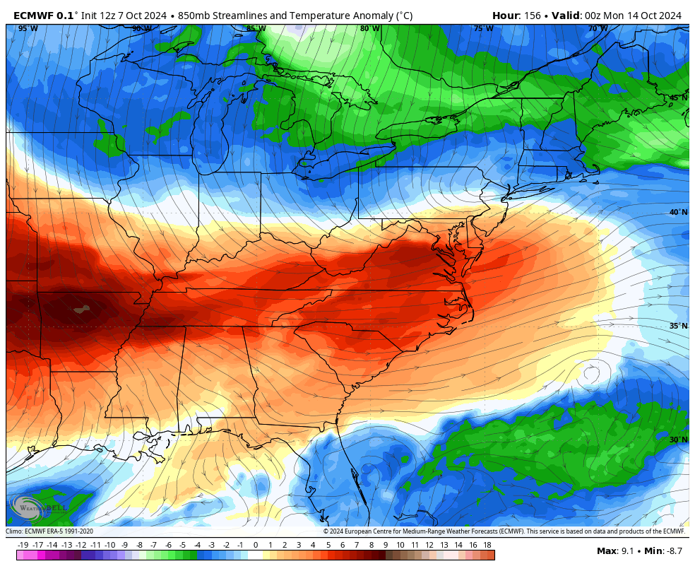
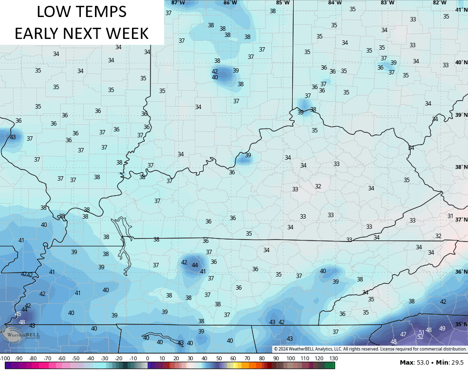
Frost will be a good bet early next week with lows that can make a run at the freezing mark…
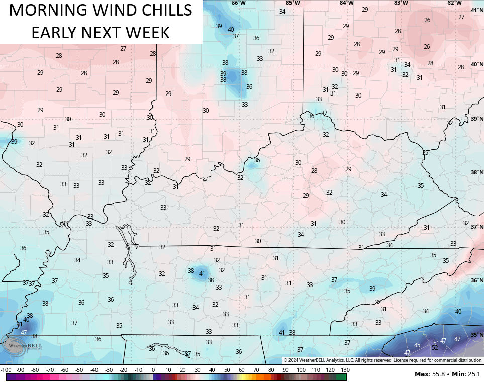
We also say welcome back to our old friend the Wind Chill map…
Highs for several days next week may not get out of the 50s. Bring. It. On.
Have a terrific Tuesday and take care.

“Highs for several days next week may not get out of the 50s. Bring. It. On.”
Gonna disagree here. 🙂
In 1976, we had high’s in the low 40 ‘s, and a hard freeze the second week in October, but that was in South Central Indiana. It was the coldest October on record, followed by a record cold Winter, with many heavy Snow events.
Get used to it,it’s that time of year.
My, you’re observant.
Thanks Chris. It is Perfect Weather here in Kentucky, but what may be causing this is what is going on in the Gulf of Mexico. I have a really BAD feeling about what may happen to the West Coast of Florida starting tonight and Wednesday. I have Family that lives in the path of the highest Storm Surge, and after a phone conversation last evening, I learned that they are planing to stay and ” Ride out the Storm . ” They waited too late to leave, as the highway is almost a parking lot going North away from the Wrath of Hurricane Milton.
My Day Will Be One Of WORRY !!!
Just got off the phone to my Sister and Brother in Law in Florida and they plan to leave today and stay with friends in Winter Haven, Florida. I’m REALLY glad and relived that they made this wise decision.
Glad they decided to leave Schroeder..Hope everyone in harms way makes it out alive with little or no damage..Unfortunately this is looking bad..
Thank you, and yes it’s looking like a Storm we will be talking about for years.
Correction, my Family went to Winter Garden which is very near Orlando. A much safer place, out of the Storm Surge, but even there, this large Storm will impact this area too. Where they were was in the direct path, in an area that has mandatory evacuations in order. By the way Hurricane Milton is back to category 5. Hoping this monster undergoes wind sheer before landfall.
So glad Schroeder they decided to go to safer ground I guess you would say. I say where a Paintsville couple got caught off guard by it but said there were going to ride it out in a hotel in Disney World I bet the same thing happened to them that happened to us we had flew most of the day And didn’t know the hurricane had changed path or track and it was headed right for us but thank God it was only a Cat 1
Thanks Crystal. Looks like the area where they lived will have devastating damage. The whole town has evaculated. Be glad when this Storm comes to an END.