Good Sunday to one and all. Our final weekend of October is wrapping up on a really nice weather note across Kentucky. This nice weather carries us into the start of the week before a more active setup takes shape. That active pattern looks to start on Halloween.
Temps today range from the upper 50s to low 60s with a mix of sun and clouds. From there, we hit deep into the 60s for Monday with the 70s back in here Tuesday and Wednesday.
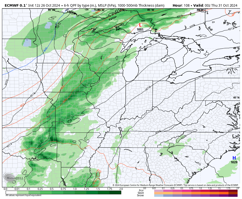
Those 70s are courtesy of a strong southwest wind flow ahead of a cold front destined to arrive for Halloween. Yep, we can’t buy a drop of rain for the month, but it spooky showers look to arrive just in time for trick or treating.
How things evolve after that is still a work in progress, though.
The EURO has some pretty good showers and gusty winds for Halloween into the first day of November. From there, the model brings additional waves of showers and some thunder in here from the southwest over the weekend into Election week…
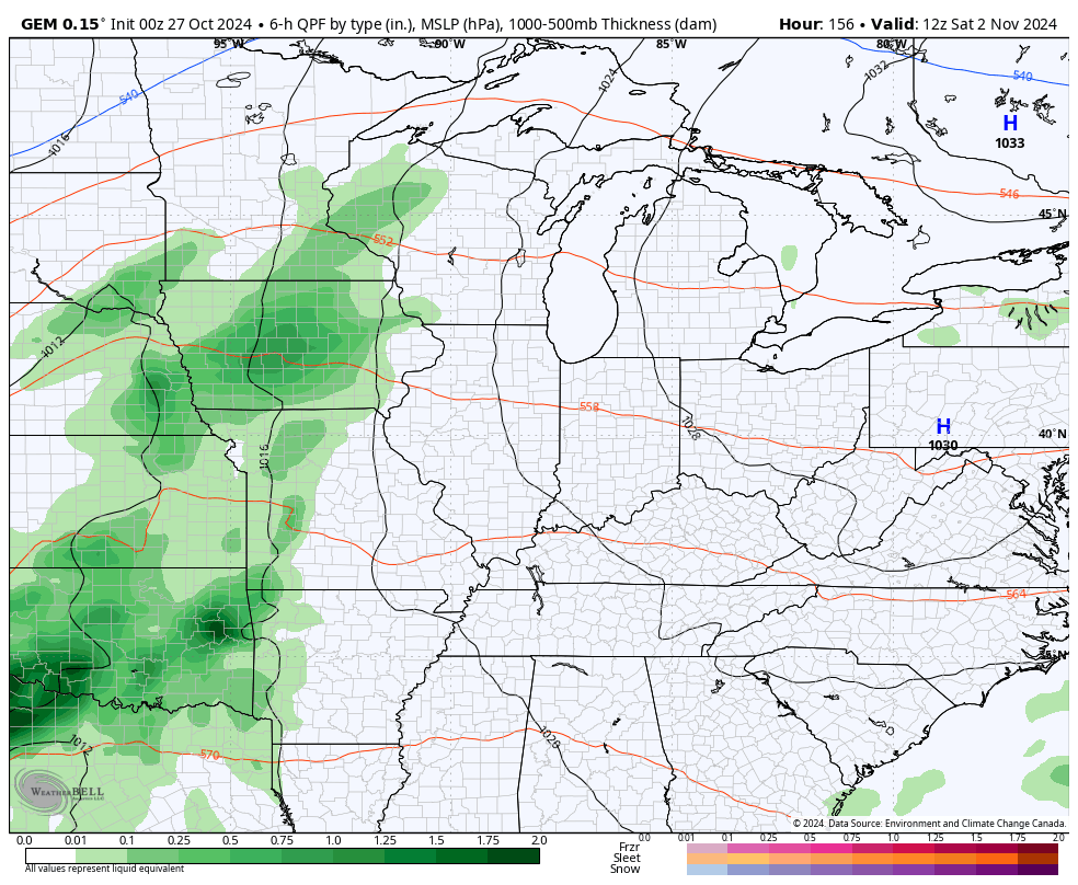
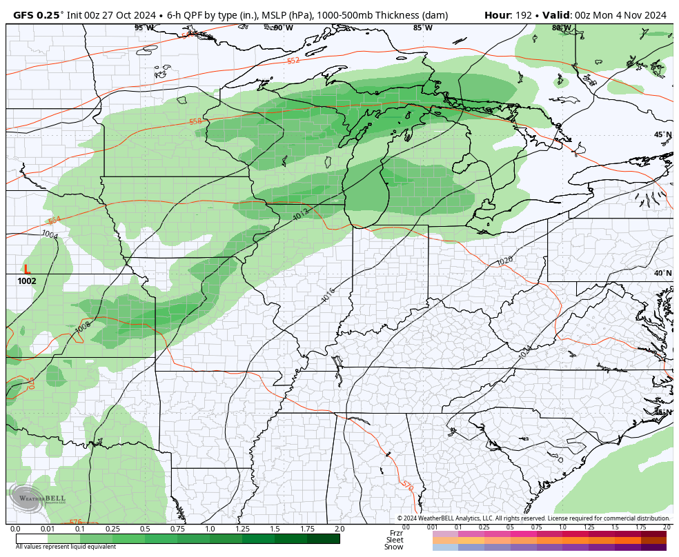
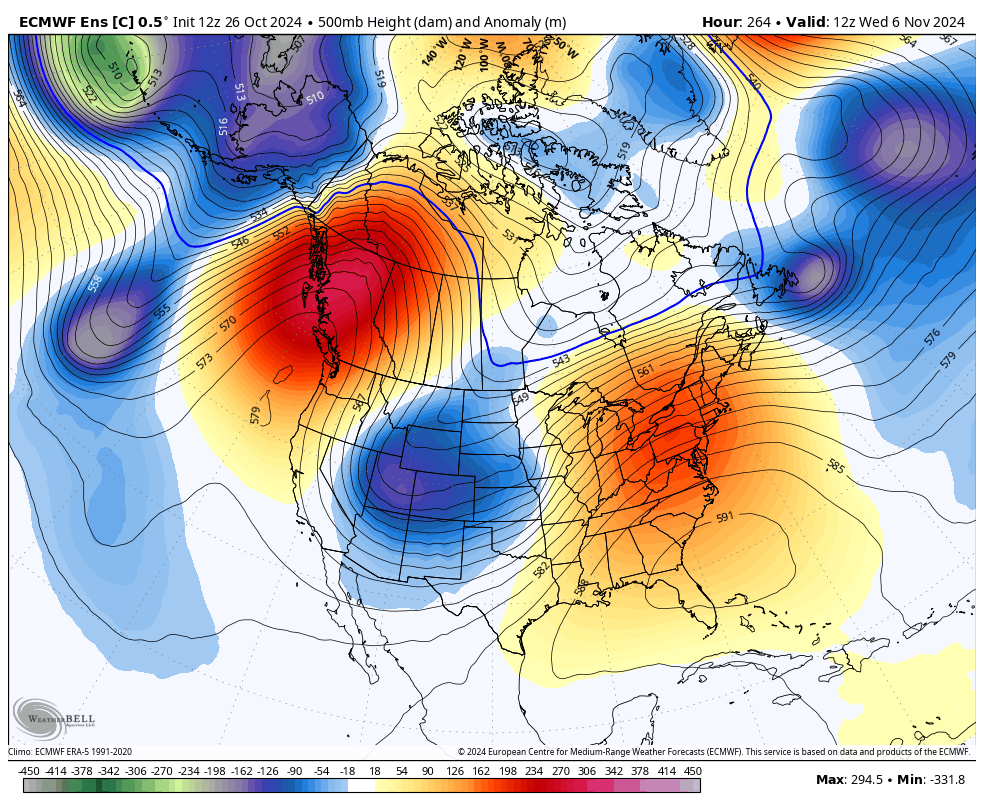
In terms of what comes after the Halloween front, we are now seeing the Canadian and GFS models seeing additional systems sweeping across the region with a colder setup behind them.
Canadian
GFS
The possible development of a tropical system in the Caribbean is something we’ve looked at over the past several days. The models have really been way too fast with that potential, but the National Hurricane Center is now highlighting the chance for development over the next 7 days…

Whatever happens in the tropics will have a huge impact on what happens across North America over the next few weeks.
The EURO Ensembles continue to indicate a deep trough into the eastern half of the country during the second week of November…
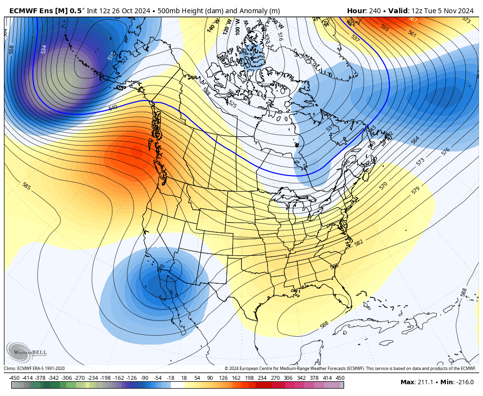
The control run of the EURO Ensembles is even more emphatic with that trough…
It’s time for a fun little look at the EURO Weeklies to see them hint at snow chances in the longer range. The current run goes through December 10th and indicates some chances for us..
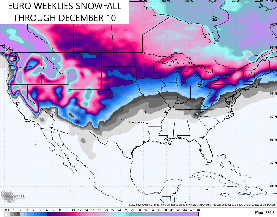
The Weeklies are an average of more than 100 model runs, btw.
The Control Run should be taken with much more of a grain of salt considering its just a single run model which will drastically change from one run to the next.
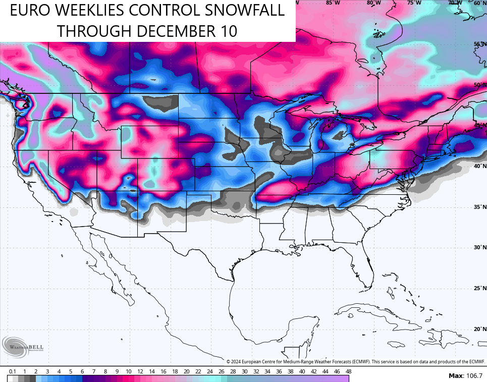
Lock it in! ha
Enjoy the day and take care.

Rather than take the weeklies with a grain of salt, it’s required a whole box of salt. Long range forecasts in general have been undependable for much of the year, unless we’re looking at a particularly strong signal. It has even affected the CPC’s ENSO reports, which makes sense since they use the GFS system.
Right now, they’re predicting a short duration, weak La Nina. It will be interesting to see what happens when we combine a weak La Nina with a solar maximum that is forecasted to peak in Q1 of 2025. Few, if any, analog years contain that combination, and it will make Winter weather predicting all the more difficult!
Agree and very true Joe. I also don’t see any changes in this long playing weather pattern. It could be decades to come before we see changes. It looks now like a very mild and dry rest of this Fall, and it most likely will continue into our Winter months. Maybe some Winter weather in February or March ?
Thanks Chris and I wish Everyone a pleasant Sunday
Wildfires so far in Kentucky this season :
https://www.google.com/search?q=has+there+been+any+wildfires+in+kentucky+2024+season&sca_esv=5a2525e9ec079db3&sxsrf=ADLYWIIBdybkEXZmea_siTcN_60XkIXCwQ%3A1730019094891&source=hp&ei=Fv8dZ6XBNJWJwbkP1-2VoQM&iflsig=AL9hbdgAAAAAZx4NJiXJ9HGOc24s4HIhfknT0d6h9SM7&oq=Has+there+been+any+wildfires+in+Kentucky+2024&gs_lp=Egdnd3Mtd2l6Ii1IYXMgdGhlcmUgYmVlbiBhbnkgd2lsZGZpcmVzIGluIEtlbnR1Y2t5IDIwMjQqAggAMgUQIRigATIFECEYoAEyBRAhGKABMgUQIRigAUiRwAJQAFjakgJwAHgAkAEAmAGMAaABnCaqAQUxMS4zNLgBAcgBAPgBAZgCLaAC3CjCAgsQLhiABBiRAhiKBcICCxAAGIAEGJECGIoFwgIOEC4YgAQYsQMY0QMYxwHCAhEQLhiABBixAxjRAxiDARjHAcICCxAuGIAEGLEDGIMBwgIIEAAYgAQYsQPCAgsQABiABBixAxiDAcICCxAuGIAEGMcBGK8BwgIKEAAYgAQYQxiKBcICChAuGIAEGEMYigXCAg0QLhiABBhDGNQCGIoFwgIIEC4YgAQYsQPCAgUQABiABMICBBAAGAPCAg4QABiABBixAxiDARiKBcICBRAuGIAEwgIIEAAYgAQYogTCAggQABiABBjHA8ICChAAGIAEGBQYhwLCAgsQABiABBiGAxiKBcICCBAAGKIEGIkFwgIGEAAYFhgewgIFECEYqwKYAwCSBwQxLjQ0oAeCrwI&sclient=gws-wiz
Long range models are not reliable for winter weather.
Weather models anymore are not reliable, but the models that predict Tropical Storms has been increasing in accuracy over the years. Models that predict temperatures across the CONUS are getting better also. Predicting Rain and Snowfall is next to imposable.