Good Friday and Happy Valentine’s Day!! We continue to track a major storm system into the region this weekend and it’s bringing a significant flood threat to Kentucky. Throw in the potential for a few severe storms and you have the makings of a wild Saturday. To make things even wilder, we end all this as some snow on Sunday.
Our Valentine’s Day finds a mix of sun and clouds with a seasonably chilly day. Highs range from the mid 30s to mid 40s across the state.
The Flood Watch for just about all of Kentucky and many surrounding states kicks off tonight and goes through early Sunday. Here’s a look at the current watch and any Flood Warnings that are out for some of the rivers across the state…
Here’s a look at what to expect:
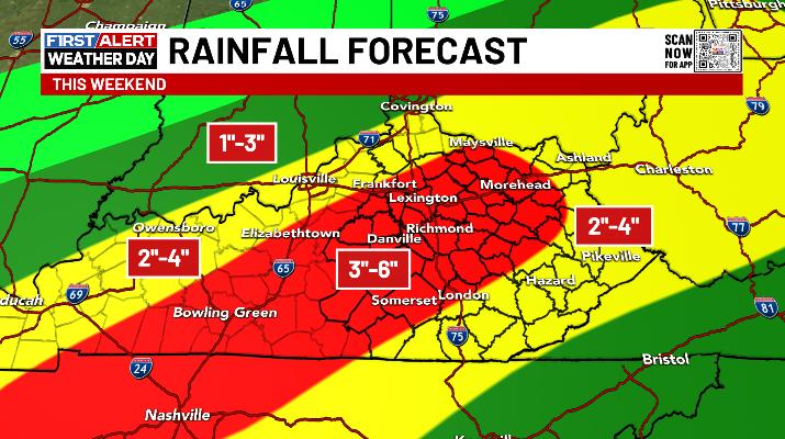
- This is a major rainmaker Saturday and Saturday night for the entire state.
- A general 1″-4″ of rain is likely during this time and that’s more than enough to create flooding.
- A southwest to northeast swath of 3″-6″ rains may very well show up. Exactly where this is remains to be seen. Some of the models have trended farther north and west with this.
- Flash flooding, general flooding and river flooding are all possible.
- Depending on the track of the low, a few strong to severe storms will be possible across central and eastern Kentucky.
- Winds will crank with this storm system and may reach 40mph or higher through Saturday night.
- Frigid temps crash in from northwest to southeast Saturday night and early Sunday.
- A 30 degree temp drop may lead to a quick ice up.
- A period of wraparound snow is likely Sunday with some accumulations possible.
- Snow showers and frigid temps/wind chills continue Sunday night and early Monday.
I’ll keep the ongoing rain forecast up for now…
Again, those lines aren’t set in stone.
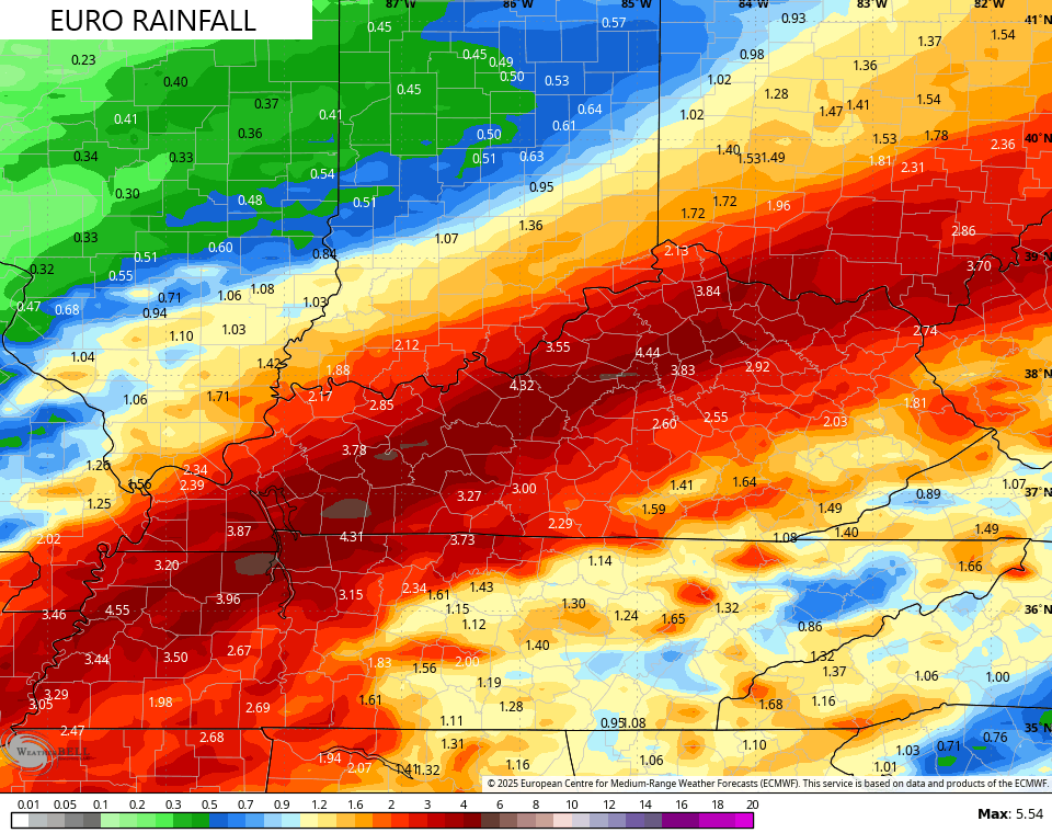
As mentioned, the models have had a bit of a west and northwest shift in terms of the axis of heaviest rains.
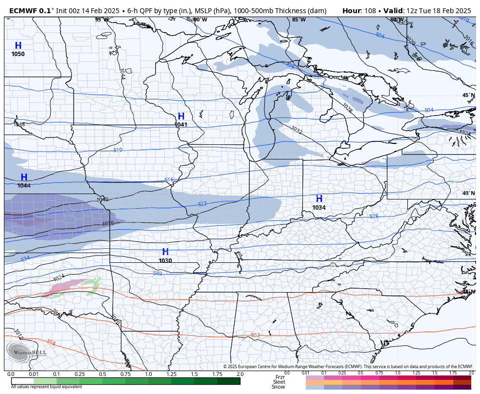
The EURO and Canadian are in pretty good agreement on where this sets up…
EURO
CANADIAN

The GFS probably has some convective feedback causing the model to push this axis too far west…

The ICON seems to be more in line of my current rainfall map…
![]()
![]()
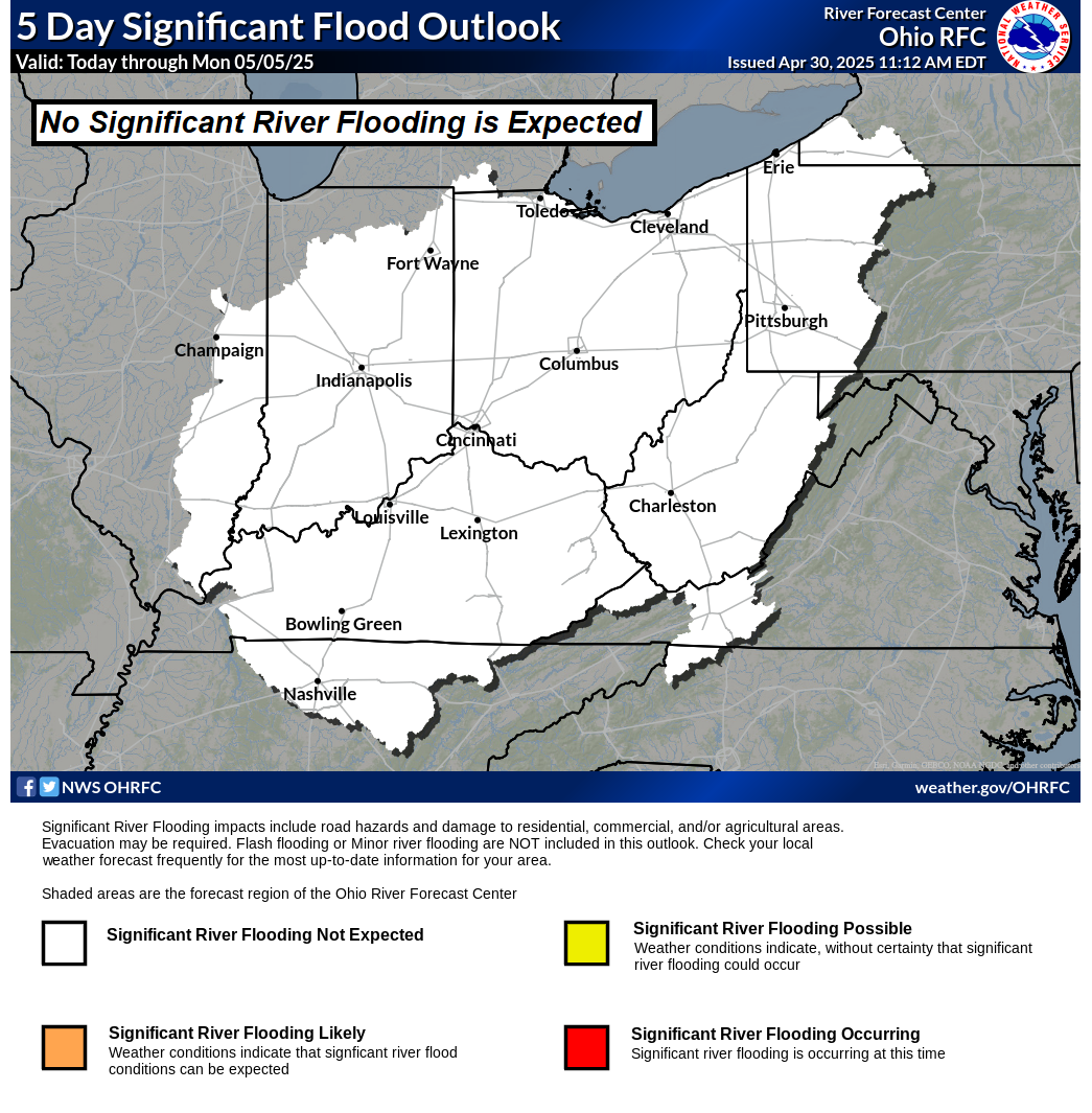
The Significant Flood Outlook from the Ohio River Forecast Center shows the potential for significant river flooding in our region…
In addition to the flooding potential, there’s the chance for severe storms to develop Saturday afternoon and evening, especially across the south. Here’s the Saturday Severe Weather Outlook from the Storm Prediction Center…

A light snowfall is a good bet behind this as cold winds pour in Sunday and Sunday night.
This kicks off a week that finds much of the country going into the deepfreeze as arctic air takes control. This will likely spawn some kind of winter storm by the middle of next week, but how this works out is still going to be a bit before its known.
Here’s how the GFS sees this…

The Canadian is a little slower with the evolution…
The EURO has a similar look…
There’s the chance for temps to make a run at 0 before next week is finished. If that happens, brutal wind chills would also show up and the models are just now starting to see this…

I’ll have your updates later today. Have a great Valentine’s Day and take care.

We’ve picked up 2.0 inches of rain so far this week in central Warren County, saturating the ground, with numerous areas of standing water visible in BG area fields. Significant rainfall on top of the 3.60 inches of rain that the region has received in February to date will almost certainly make a bad situation worse.
We need sun, warmth, and to dry out for about a week.