Good Saturday, everyone. Today is one of those days where you need to stay very aware of the weather as the threat for a major flood is high across Kentucky. This flooding could be accompanied a few strong to severe storms and high winds before winter threatens us from Sunday into next week.
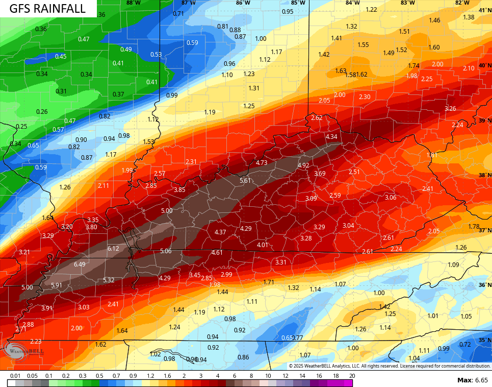
Waves of heavy rain producing showers and storms will feed from southwest to northeast across Kentucky today and Tonight as low pressure rolls into the region. Several inches of rain will be likely with the potential of a corridor of 6″+ rains showing up.
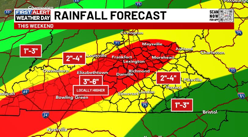
This will lead to major flash flooding, major general flooding, and moderate to major river flooding. You can follow along with the warnings and watches on this map…
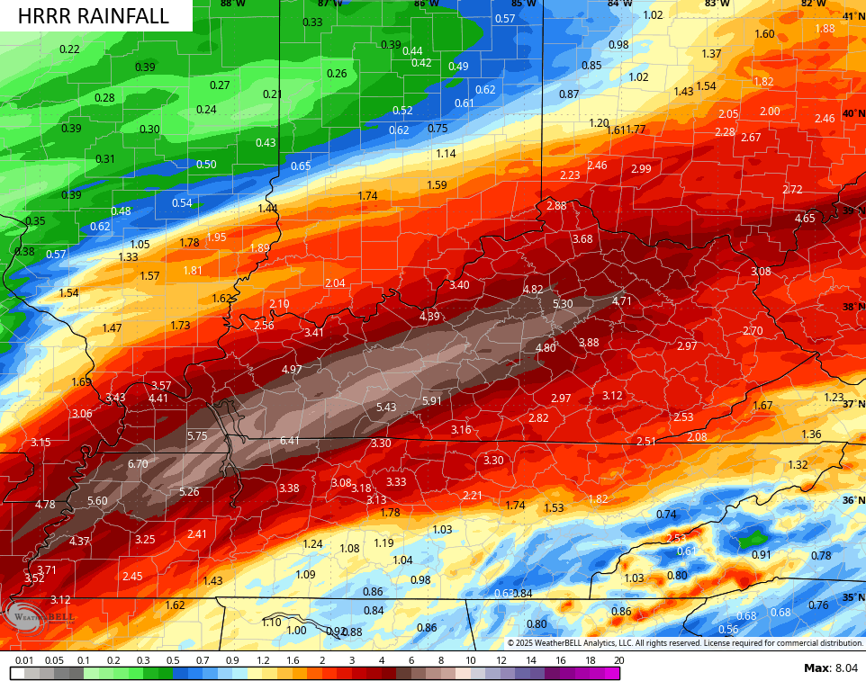
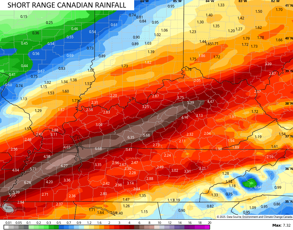
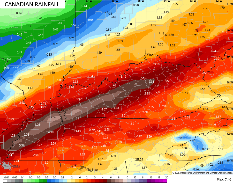
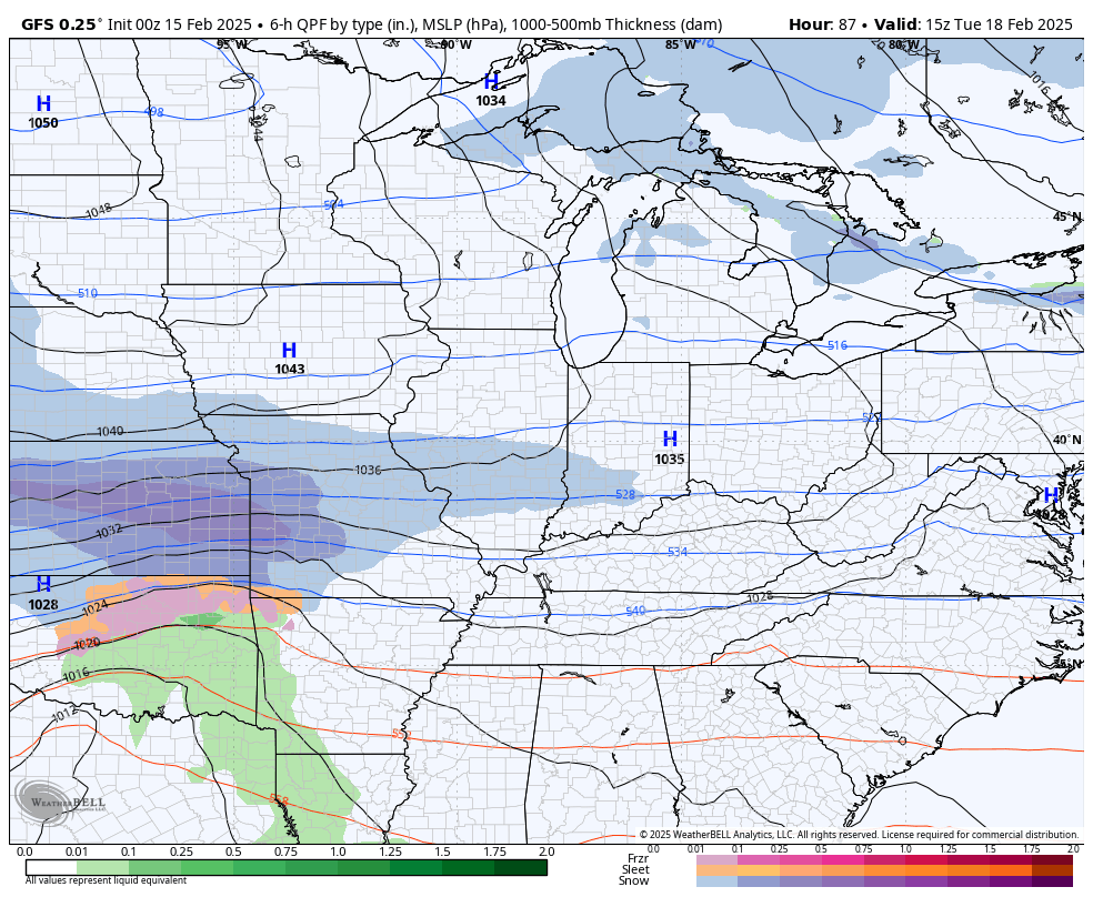
Most of the models are now following along with my forecast area of heaviest rains…
![]()
![]()
The threat for a few strong to severe storms shows up from late this afternoon into the evening hours with the greatest risk across south central Kentucky. Here’s today’s Severe Weather Outlook from the Storm Prediction Center…

Damaging wind is the primary player, but there is a small risk for a tornado or two spinning up…

As the cold front crosses the state early Sunday morning, we turn the faucet off as cold winds crash in from the northwest. A period of light snow is likely right behind the front with snow showers kicking in during the afternoon and taking us into Sunday night across central and eastern Kentucky. You can see this all on the Hi Res NAM future radar…
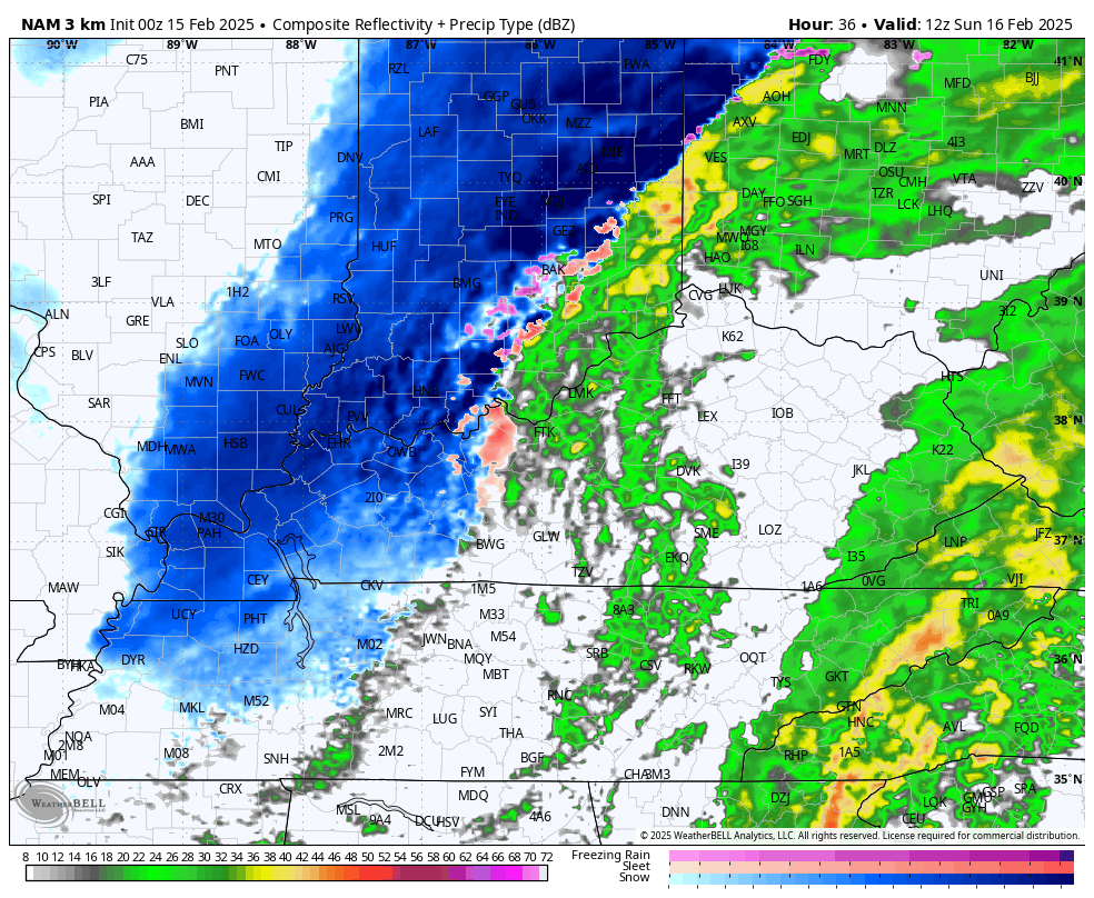
Light accumulations are likely with a few areas picking up an inch or two.
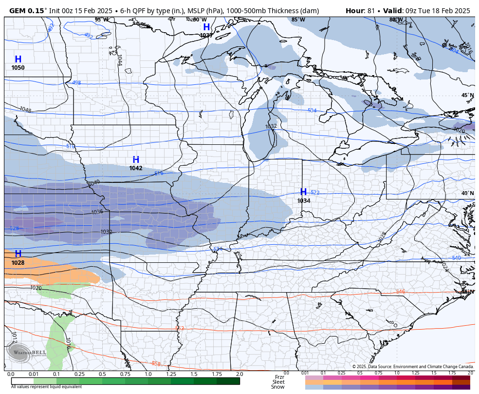
This kicks off a very harsh week of winter weather with a likely Winter Storm THREAT coming for late Tuesday through Thursday. The signal for a major eastern US winter storm continues to show more and more as we get closer. With arctic air in play, we are likely looking at a high ratio snowstorm that can throw down some hefty numbers.
The Canadian has a heck of a look…
So does the EURO…
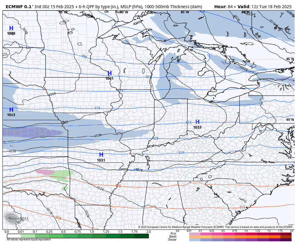
The GFS is doing what the GFS does but it’s showing the signal in its own special way…
This one passes the look test as of now.
Bitterly cold temps and wind chills will accompany this storm and will follow it into next weekend.
I will try to update things a few times later today and have breaking weather coverage on WKYT as needed. Until then, I leave you guys with your shower and storm tracking tools for the day…

Current watches

Possible Watch Areas

Stay safe and have a great Saturday. Take care.

Thanks Chris. Very heavy Rains here in Maple at the present. Being in the hills of central Kentucky, flooding isn’t a concern, but I am concerned about the other parts of the state. I’m glad that we are receiving the Rains now, because March weather is usually windy and dry or Snowy and cold or Summer like. Take your pick. The models are agreeing on a Snowstorm for mid week. Hope it pans out.
Be Safe Everyone !
Heavy rain with a few rolls of thunder mixed in continues over south central Kentucky. My PWS has picked up 1.60 inches of rain since midnight, and 3.60 inches for the week to-date. Wind gusts have been strong, especially in thunderstorms, with a peak gust of 35mph recorded overnight. With the ground as saturated as it is, there is a real threat for trees to be uprooted, so be very careful while driving in the area today.
At 10:45 am CST my PWS just south of Bowling Green has recorded 2.85 inches of rain since midnight,and rain continues to fall at an average rate of .45 inches per hour.
The NWS has issued an Areal Flood WARNING for most of south central Kentucky, including all of Warren County. I have seen many instances of Areal Flood Watches, but I cannot recall ever seeing a warning issued for such a wide area. The WPS has also updated the Excessive Rainfall Outlook, designating all of western and most of south central Kentucky in the extremely rare High category for excessive rain. There is widespread street flooding in Bowling Green, with residents beginning to report water in their homes.
https://page.alertsense.com/a/1749497
https://www.wpc.ncep.noaa.gov/#page=ovw
So far Lexington is getting spared the heavier rains as it’s still training south of us. As of noon my PWS is at .67 for today and 6.27 for the month.
I’m scheduled to have carpal tunnel surgery this Wednesday, now this has me worried.