Good Monday, everyone. As the Commonwealth tries to recover from deadly and devastating flooding, Mother Nature is still in an unforgiving mood with a harsh week of winter weather on tap. Snowy roads are out there this morning with a winter storm on the way.
Many Kentucky counties and rivers are still under Flood Warnings and will be for a bit longer, especially along the rivers where severe flooding is ongoing. We also start the day with a Winter Weather Advisory for some and Winter Storm Watches and possible warnings for the next system.
To say this Watch/Warning/Advisory map is colorful is an understatement…

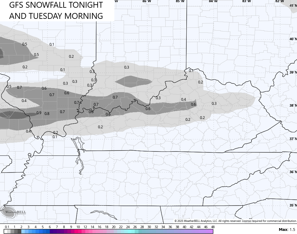
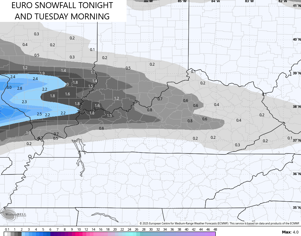
Light snow streaks into the region from the west late tonight and early Tuesday. That will bring a swath of light accumulations in a narrow band and will likely cause some slick spots.
Our developing winter storm then rolls from west to east across the state Tuesday night through Thursday. Here’s what I think we know:
- Low pressure rolls from west to east across the deep south.
- Heavy snow pushes into western Kentucky Tuesday evening and expands eastward overnight.
- A swath of heavy snow goes from west to east across Kentucky Wednesday and Wednesday night.
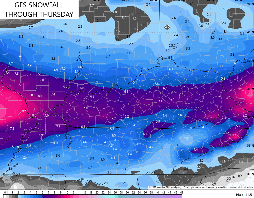
- A general 2″-8″ shows up across the state with the heaviest amounts likely along and south of Interstate 64.
- With very cold air in place, this snow should have a good fluff factor.
- Additional light snows develop on Thursday as the upper low drops in from the northwest.
- This entire system will be a HIGH IMPACT travel event for the entire state.
- Bitterly cold temps and wind chills show up with and behind this system.
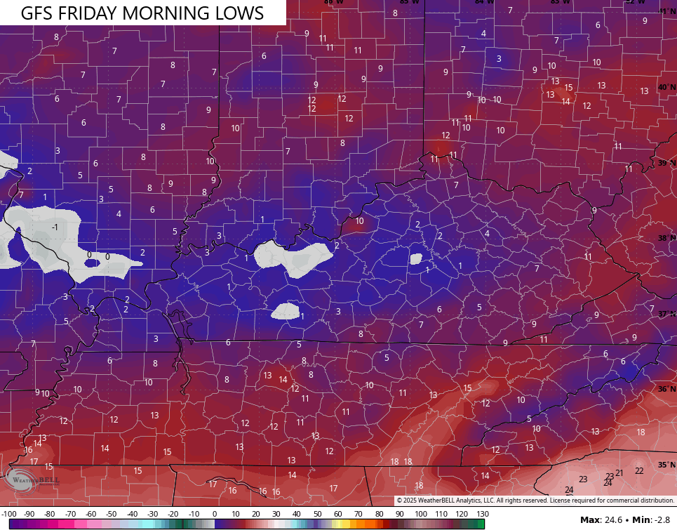
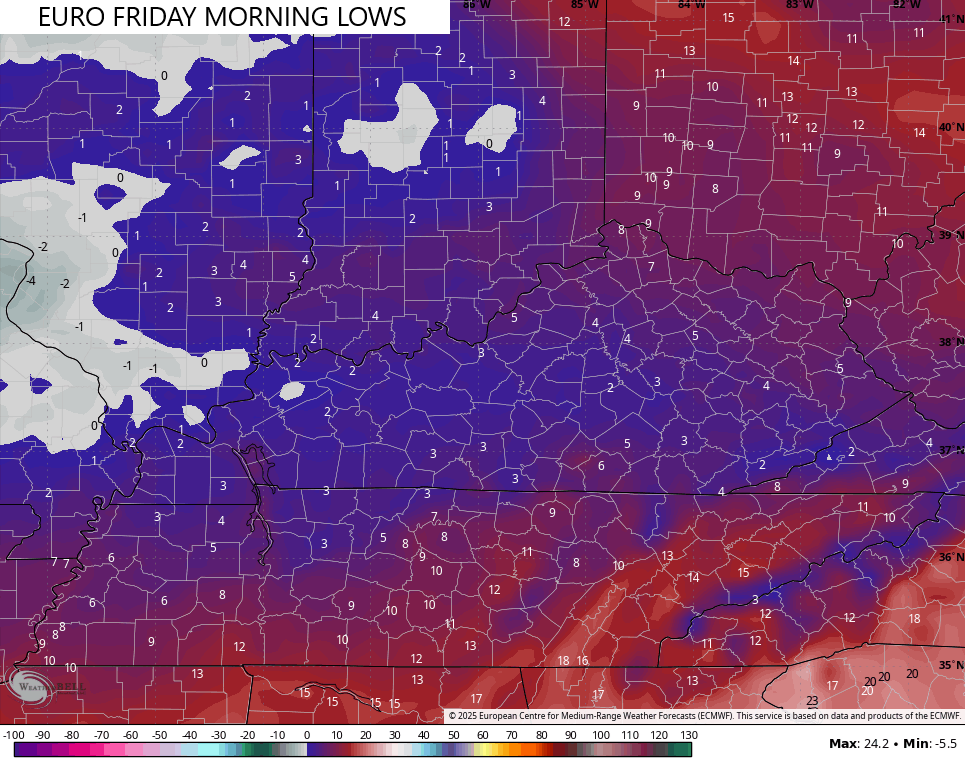
- Lows can get to near 0 by Friday and Saturday mornings.
- Wind Chills can go below 0 as early as Wednesday night and be with us on and off through Saturday morning.
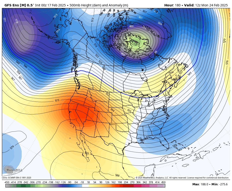
Believe it or not, I think the GFS has a pretty good handle on this whole setup, as does the EURO.
Here’s what it has for the “sneaky” light snowfall tonight and early Tuesday…
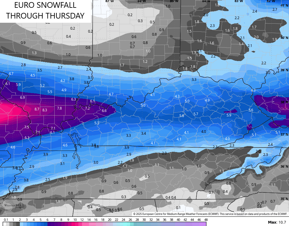
Here’s my First Call for Snowfall through the entire event…
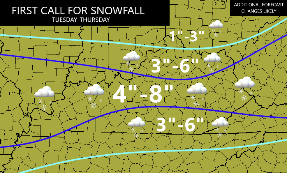
You can see how the swath of heavier snows becomes narrower through central Kentucky before picking back up in the far east. There’s a chance I split that into two areas of 4″-8″ with one in the west and one far east. That would leave central Kentucky in the 3″-6″ idea.
The GFS is the most aggressive model with total snow numbers…
The EURO is a little lighter…
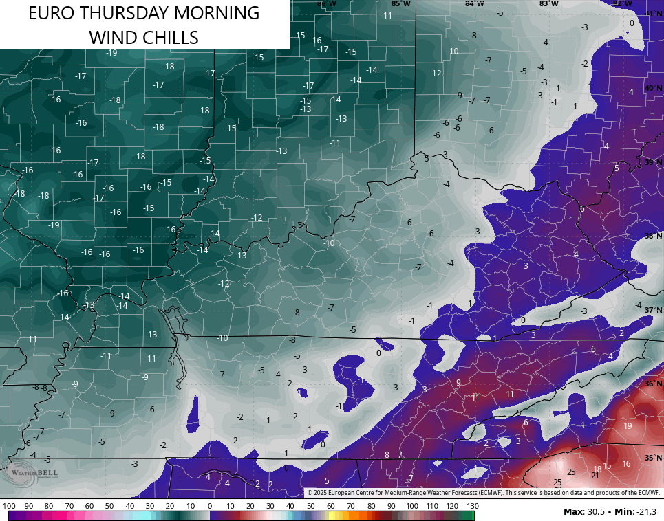
Bitterly cold wind chills will accompany the Wednesday system and those numbers absolutely tank by Thursday and Friday mornings. Wind chills go well below zero by Thursday morning…
Actual low temps make a run at 0 or below by Friday morning…
This is just a very ugly week of winter weather, folks.
I’d really like to say we are done with winter, but the pattern for the final week of February into the start of March potential for more winter weather…
Updates come your way later today. As usual, I have your tracking tools including our Kentucky Weather Cams to watch the wild weather across entire region…

Enjoy your manic Monday and take care.

If we want winter… we need to remember what the signals are and have been since Jan because apparently those are the signals we want. The weather has been pretty crazy since the start of January.
We don’t want winter anymore.
It’s 36 hours later, and we’re still picking up the pieces from the flooding in south central Kentucky. Here in central Warren County, I recorded 6¼ inches of rain in 24 hours, and although my property was spared, the same isn’t true for many of our friends and neighbors.
And this week’s sub-freezing temperatures will turn flood waters into sheets of ice, making travel dangerous and seriously impeding recovery operations.
I am sorry to hear this, JoeD. That is a staggering amount of rain to fall within 24 hours. It’s devastating. But I am glad you are safe. It is going to be a long road for so many to recover, and this severe winter weather is going to impede that.
Thanks Stormtracker! The fact that the flooding occurred in the middle of February has made a tough situation even more difficult, primarily due to the forecasted drop in temperature. Wednesday we’re supposed to get down to 8°F overnight and 0°F on Thursday. It’s more challenging to get flood waters to recede when they’re frozen solid!
Thanks Chris. I don’t have the words to express my feelings for all the Flood victims out there. I have never been a victim of Flooding, so I don’t know how it is. All I can offer is my prayers for those who had to endure this awful weather event.
Here in Maple, we had about 5.00 inches of Rain plus a Thunderstorm, followed by a Beautiful wet Snowfall yesterday morning of around 2 inches.
The Snowstorm that is forecast this mid- week needs to be watched, as the potential for more Snow than we want is definitely there.
Be Safe Everyone !!!
I’m with you Jeff ready for spring and summer.