Good Wednesday to one and all. We continue to track low pressure that’s moving away from the region and a surge of summer air moving in for the next few. This juicy air will combine with a system moving in from the west to produce strong to severe storms.
Temps today reach the upper 70s to low 80s with a mix of sun and clouds. A couple of showers and storms will spin up across central and eastern Kentucky as the low pulls away. There’s also the chance for a few thunderstorms to pop along the leading edge of the summer air moving in from the west this evening. Those would be moving from southwest to northeast.
Highs for Thursday jump deep into the 80s with the chance for one of the airport thermometers to reach 90. Humidity levels will also be way up, bringing our first muggy feel of the year.
A few thunderstorms may develop late in the day or during the evening hours, especially to our west and northwest. For this reason, the Storm Prediction Center continues with a low-end severe weather risk for Thursday…

The threat for severe storms will then really increase Friday into Friday night as low pressure drags a front through here. Waves of strong to severe storms will be moving across the region during this time with the possibility of damaging winds, large hail and even a few tornadoes.
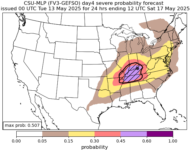
Here’s the Severe Weather Outlook for Friday…

The latest CSU Forecast Machine Learning indicates the bullseye of severe storms for Friday is right on top of us…
The cold front blows through on Saturday with calmer weather moving in. That front checks up allowing for a cluster of storms to roll from west to east along that boundary Sunday. From there, the setup next week through early Memorial Day week is primed for rounds of strong to severe storms to impact our region.
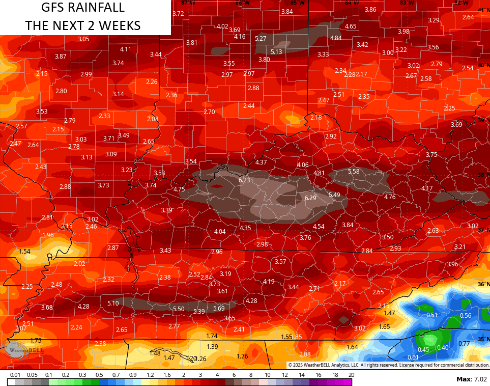
The forecast models are seeing this well and they’re seeing the possibility of a lot of rain during this time…
EURO

GFS
Ugh.
I leave you with your daily dose of storm tracking tools…

Make it a wonderful Wednesday and take care.

I hope the models fail miserably. 🙂
A 90 % chance that this forecast will be corect, but long ranged model forecast are just a guess. Example, NOAA is predicting that ENSO / La Nina will return for this Fall and Winter, but this is just another educated guess. At the present the PDO reading is a negative 1.18, which would mean that a weak La Nina is still present in the Tropical Pacific. It’s not exactly ENSO / neutral in my opinion. The Atlantic and Caribbean Hurricane season could be very active later in the Summer and early Fall, but this is just another guess.