Good Monday, everyone. With smoke in our skies, summer temps are showing up with the warmest air of the year, so far. This summer air will lead us back into a very stormy pattern that kicks off later this week and likely hangs tough into next week.
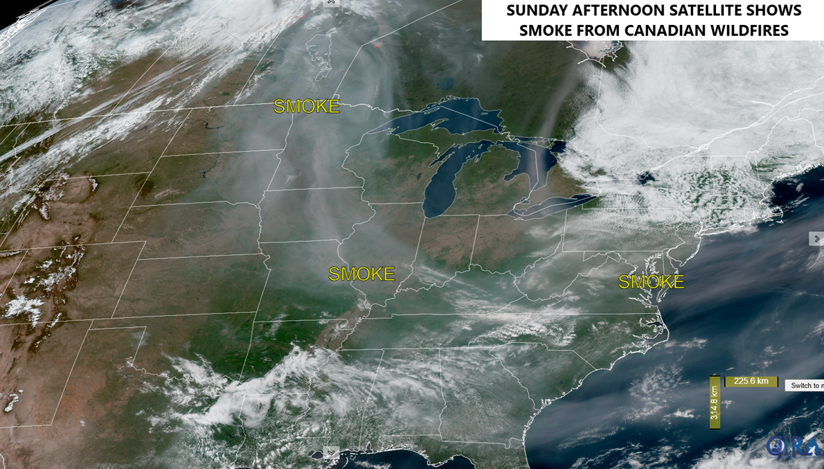
Let’s start with the smoke filling the skies. This is coming from the Canadian wildfires that continue to burn out of control. Check out this satellite shot I grabbed from Sunday afternoon showing the smoke very well…
Temps this morning are into the 40s across parts of central and eastern Kentucky with 70s coming up this afternoon. The west will see temps deep into the 80s.
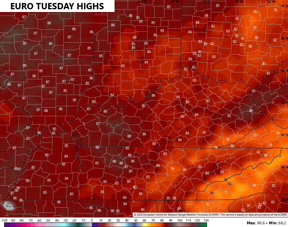
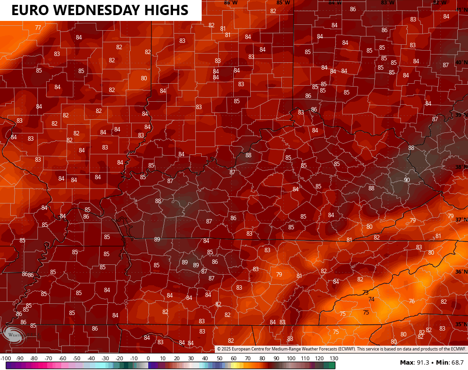
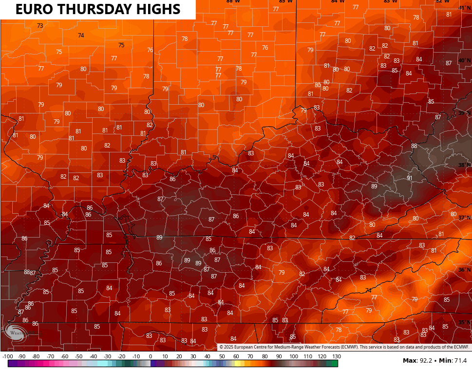
Those 80s surge eastward Tuesday through Thursday with the chance to push 90 in some areas. Take a look at the daily forecast highs from the EURO…
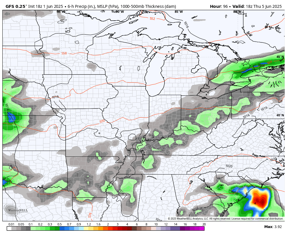
This takes us to the period I highlighted several days ago as turning active…
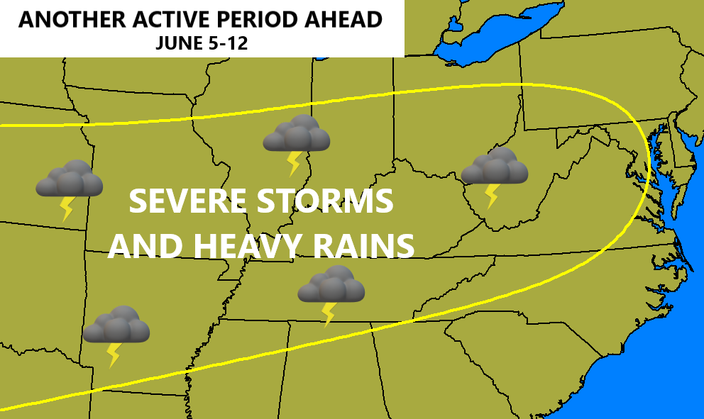
The models are picking up on this more and more as we get closer. As a matter of fact, they keep this going several days past the time period…
GFS
EURO
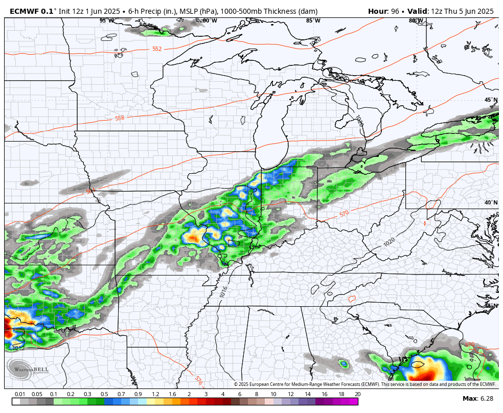
All of this likely puts down a lot of rain…
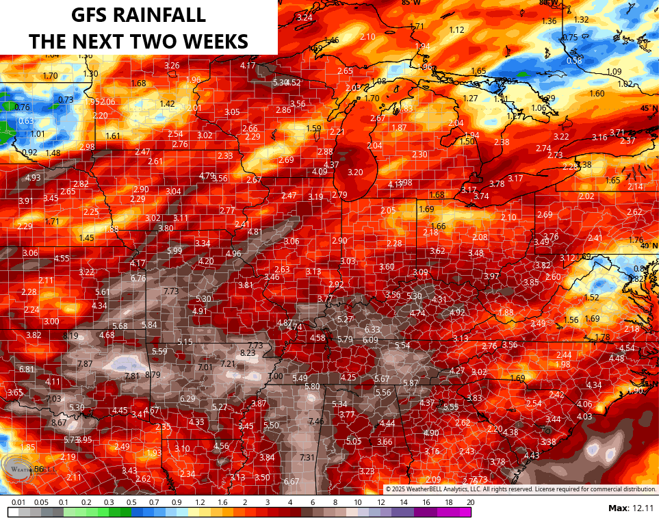
Summer is, as we know all too well, flash flood season here in Kentucky. Stay alert.
Have a great Monday and take care.

The smoky skies are an unnecessary form of pollution. This is NOT healthy, as many people could suffer. What are we suppose to do ? Wear those stupid mask all the time we are outside. It does give us colorful Sunrises and Sunsets though.
https://www.google.com/search?q=why+canada+has+been+having+wildfires+out+of+control+over+the+years&sca_esv=f6bc877b3d7fa12d&sxsrf=AE3TifOCYlPZuM9d7Q0v_mGx4EFrOu9-qQ%3A1748863443199&ei=04k9aPz4C_6EwbkPkfWMqAo&oq=Why+Canada+has+been+having+wildfires+out+of+control&gs_lp=Egxnd3Mtd2l6LXNlcnAiM1doeSBDYW5hZGEgaGFzIGJlZW4gaGF2aW5nIHdpbGRmaXJlcyBvdXQgb2YgY29udHJvbCoCCAEyBRAhGKABMgUQIRigATIFECEYoAEyBRAhGKABSOnpA1DOI1jZ_gJwAXgBkAEAmAGZAaABvyyqAQUxMi4zObgBAcgBAPgBAZgCNKAC-i-oAgrCAgcQIxgnGOoCwgIUEAAYgAQYkQIYtAIYigUY6gLYAQHCAhQQABiABBjjBBi0AhjpBBjqAtgBAcICBBAjGCfCAgoQABiABBhDGIoFwgILEAAYgAQYkQIYigXCAhAQABiABBixAxhDGIMBGIoFwgIKEC4YgAQYQxiKBcICFBAuGIAEGLEDGNEDGIMBGNQCGMcBwgIIEC4YgAQYsQPCAgUQABiABMICDhAAGIAEGLEDGIMBGIoFwgIIEAAYgAQYsQPCAgoQABiABBgUGIcCwgIEEAAYA8ICBhAAGBYYHsICCBAAGIAEGKIEwgIFEAAY7wXCAgUQIRirAsICBxAhGKABGArCAgUQIRifBZgDHfEFJzA1iw_2_bS6BgQIARgBkgcENS40N6AH0ooCsgcENC40N7gH3S_CBwswLjEuMzQuMTUuMsgH4AI&sclient=gws-wiz-serp
Adding to the above, I don’t believe that Climate Change is the cause. Western Canada finished a very cold Snowy Winter. How could it be that hot and dry this early ? Something else is causing the Wildfires.
Early spring record breaking temperatures, higher wind speeds and a years long drought, all symptoms of Climate Change, are very likely to blame for an increase in wildfires, especially in the boreal forests.
https://vancouversun.com/news/wildfire-crisis-in-western-canada-why-is-this-happening#:~:text=It's%20not%20yet%20summer%2C%20but,temperatures%20and%20lack%20of%20rainfall.
Couldn’t get into the link Joe. It kept knocking me off, but I am not buying into the whole Climate Change bit.
Not a very good forecast to start Summer. Maybe our Autumn will be better ?
The Chicago Metro Area experienced an extremely rare dust storm last month on May 16th. The dry conditions, strong southerly winds, and loose topsoil from the farms on Central IL all combined to create the dust storm. Dust Storm Warnings (only the second time ever the Chicago NWS has issued one) were issued for the entire Metro Area in the early evening, with visibilities as low as under 1/4 mile.
That shows how dry it’s been here in Northern and Central IL this Spring, which is quite a contrast to you guys in KY, who have gotten soaked with rain.
Here is the link that summarizes the dust storm: https://weather.gov/media/lot/events/2025/05_16/2025_05_16_Dust_Storm.pdf
Mike, One can expect any kind of weather in the Midwest. Thanks for sharing the link.
I didn’t know this. I didn’t realize Chicago had been so dry…. As for the fires in Canada.. (just like last year) you can’t rule out Arson