Good Thursday, everyone. Rounds of thunderstorms have been dumping torrential rains across the region over the past few days and, unfortunately, the worst is yet to come. Significant flash flooding issues may develop at times over the next several days. There’s also the chance for some strong and severe storms.
Parts of Kentucky have picked up 3″-4″ of rain over the past few days, highlighting just how much rains these storms can put down.
As a cold front drops in from the northwest and slows down today, it interacts with deep tropical moisture to produce torrential rains. The threat for flash flooding is elevated today and the Weather Prediction Center is highlighting this potential…

Some of these storms may also be strong to severe with damaging winds as the primary threat. Here’s Today’s Severe Weather Outlook from the Storm Prediction Center…

Friday will feature a similar atmosphere with rounds of thunderstorms rumbling through with a continuation of the flash flood threat.
The pattern this weekend and early next week will find big clusters of thunderstorms developing to our northwest and rolling into Kentucky…

The end result will be some strong to severe storms with an increased risk for flash flooding. Here’s the area I’m highlighting for the Highest Risk…
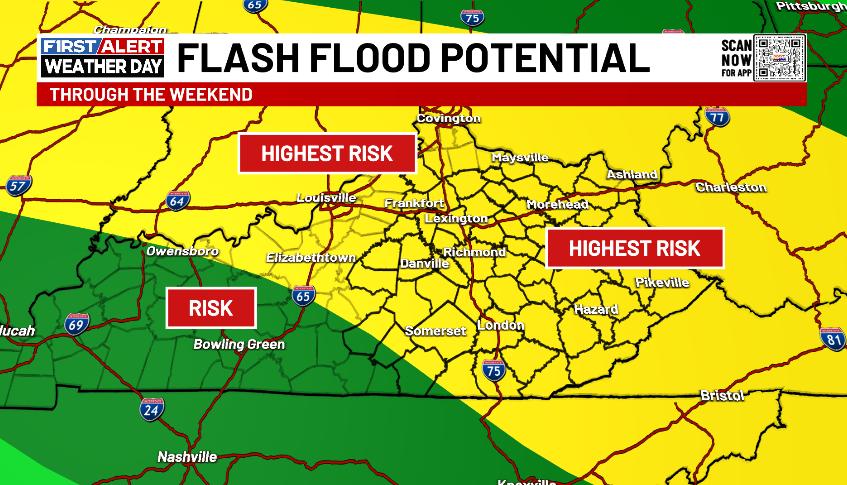
The Weather Prediction Center is now also seeing this potential and highlighting Saturday and Sunday for possible flash flooding…


Outside of any storms, temps are super steamy and may turn pretty darn toasty, especially into next week.
I’ll have the latest on WKYT-TV starting at 4pm today. As usual, I have all your storm tracking tools for the day…


Current watches

Possible Watch Areas

Make it a great Thursday and take care.

What happen to the cool spell that supposed to take place today. Jeff I hope your enjoying this hot spell that were stuck with.. So much of below normal temps that was advertised on here.
I’m loving it, but at some point it will go away.
So KLEX is like 42 inches for the year since they got dumped on with rain yesterday.. I’m trying to remember if I’ve ever seen that amount of precip at this point in the year.. I wonder if the top wettest year ever had reached this much precip at this point in the year?
It’s hard to believe that the area is so far above normal overall, yet some are complaining about dryness of late.