Good Thursday, everyone. The steam is becoming rather rude as heat indices continue to climb. With the steam comes the increasing threat for scattered showers and storms into the upcoming weekend. If you’re looking for some more of the comfy stuff… Early August just might be to your liking.
Temps today range from the upper 80s to low 90s in many areas with the west doing it a little better. Humidity levels climb with the west reaching 105-110 at times. The rest of the state mainly hangs out in the 95-100 degree range with a few spots in the central and north doing it a touch better.
This same outlook is with us Friday into the Weekend, but storms will have the final say on that.
The threat for scattered storms is with us today and that risk climbs over the weekend and early next week…
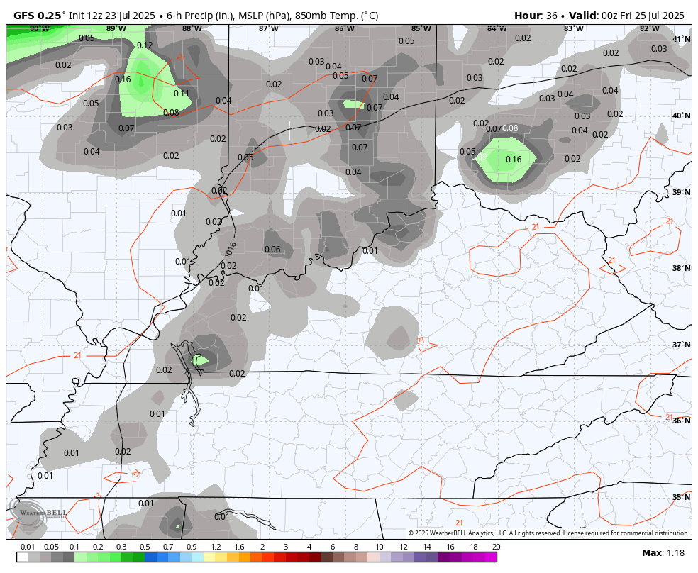
Any showers and storms will keep temps held in check. A strong storm or two will be possible and some of these may pack a torrential rain punch.
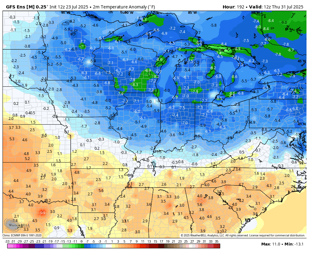
Tuesday and Wednesday of next week may wind up being the hottest days of the summer as we get ready for a different pattern to take over. This cooler setup looks to arrive as we flip the calendar to August.
The GFS Ensembles have this in hand…
As do the EURO Ensembles…
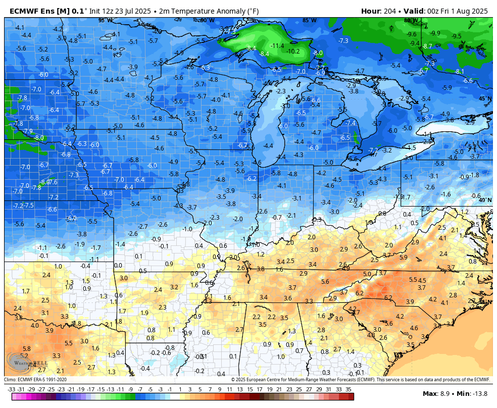
I’ll take that and run with it.
I leave you with your full complement of Sunday storm tracking tools…


Current watches

Possible Watch Areas

Make it a sensational Sunday and take care.

Thanks Chris. Getting really tired of the steamy temperatures and scattered shower setup. Looking forward to the current high pressure ridge weakening and relocating to our west, so some cooler drier air can move into our area of the country, but going into the last month of Summer the heat and humidity, along with high dew points will likely return.
Not buying it.
I think it will Jeff for a little while, but never fear Summer weather will return in August.
Its been hot, but not like the summer of 2012. Hope that cool air verifies.
If I recall correctly, 2012 had a relatively dry spring, and that pattern continues through the summer. Unlike this year, we didn’t have lush foliage and high water table levels, which translated into lower dewpoints combined with higher than normal temperatures. This year, we’re getting the worst of both worlds.
Unfortunately,I think as we get into autumn, that extra atmospheric moisture could to lead to a more active fall severe weather “season”.
I hope it doesn’t.
https://www.google.com/search?q=summer+weather+2012+in+kentucky&sca_esv=677f3ddbc8bf65e8&sxsrf=AE3TifNTDMZUdBBSgCX_87FSSpED-1jWoQ%3A1753379512356&source=hp&ei=uHKCaOHAEvynqtsP4MyswA0&iflsig=AOw8s4IAAAAAaIKAyFOKJdmqiR67iBdbhOdhsbS1Dyz1&oq=Summer+weather+2012+in+Ky.&gs_lp=Egdnd3Mtd2l6IhpTdW1tZXIgd2VhdGhlciAyMDEyIGluIEt5LioCCAEyBRAhGKABMgUQIRigATIFECEYoAEyBRAhGKABSNzEAVAAWJOjAXAAeACQAQCYAbsBoAHhFqoBBTExLjE1uAEByAEA-AEBmAIaoALkF8ICERAuGIAEGJECGNEDGMcBGIoFwgILEAAYgAQYkQIYigXCAgoQABiABBhDGIoFwgIOEC4YgAQYsQMYgwEYigXCAgUQLhiABMICERAuGIAEGLEDGNEDGIMBGMcBwgILEAAYgAQYsQMYgwHCAg4QLhiABBjHARiOBRivAcICDhAuGIAEGLEDGIMBGNQCwgIOEC4YgAQYsQMY0QMYxwHCAgUQABiABMICCBAAGIAEGLEDwgIOEAAYgAQYsQMYgwEYigXCAgsQLhiABBixAxiDAcICERAuGIAEGLEDGIMBGNQCGIoFwgILEC4YgAQYkQIYigXCAhAQLhiABBixAxhDGIMBGIoFwgINEC4YgAQYQxjUAhiKBcICBBAAGAPCAgYQABgWGB7CAgsQABiABBiGAxiKBcICCBAAGIAEGKIEwgIFECEYqwKYAwCSBwQ3LjE5oAeRywGyBwQ3LjE5uAfkF8IHCDAuNC4yMS4xyAdp&sclient=gws-wiz
No surprise, 2012 had a negative Pacific Decadal Oscillation ( PDO. ) I’m beginning to think now that it may be several years to come before the PDO returns to positive, to give our area of the CONUS decent seasonal changes.