Good Friday to one and all. We continue to deal with all kinds of tropical humidity, steamy temps and scattered storms. This is a pattern locked in through early next week before we change it up by the time we hit August.
Temps out there today are in similar territory to what we had on Thursday. Highs across central and eastern Kentucky are generally in the upper 80s to low 90s with a heat index of 95-100. The western half of the state is sweating even more with temps 90-95 and a heat index of 105-110. The chance for a storm or two to go up is there and that can impact temps for some.
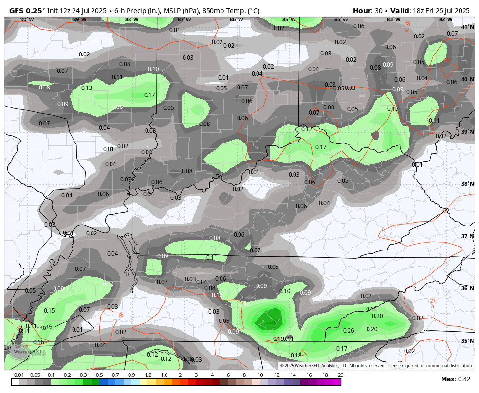
Saturday and Sunday look similar to today in terms of temps with a little more in the way of scattered showers and storms. The more storms we can get, the lower the temps and heat index numbers during the afternoon hours.
You can see these showers and storms going up from later today through Monday…
Temps Tuesday and Wednesday may be even steamier than what we have out there today as we gear up for a strong cold front to sweep in at the end of the month. This boundary will usher in some pretty comfy air to start the month of August.
I don’t think too many folks would complain with numbers going below normal…
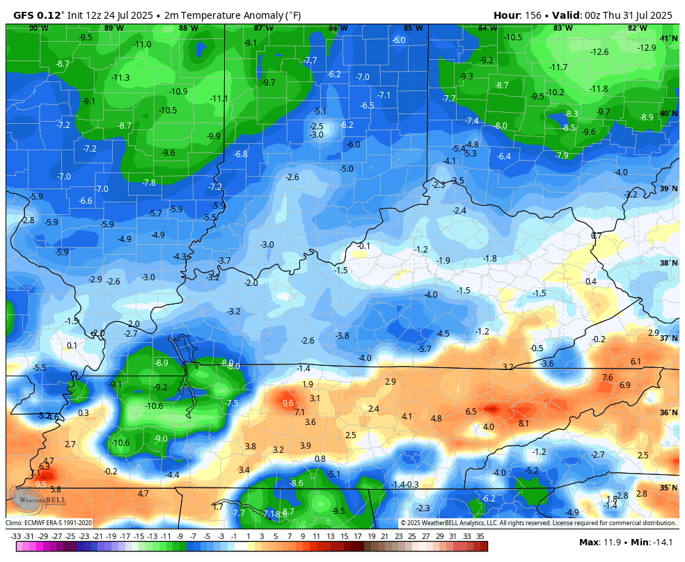
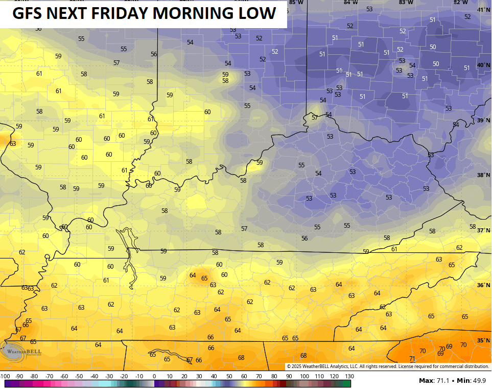
That’s some pretty awesome air waiting on us and the GFS is going downright awesome for the first day of August…
I leave you with your full complement of Sunday storm tracking tools…


Current watches

Possible Watch Areas

Make it a fantastic Friday and take care.

Thanks Chris. I hoping that we may have cloudy late afternoons to relieve a little from this excessive heat. As far as the cool down predicted late next week, it may be for just a few days. It’s this I call a La Nina High Pressure System that bringing all the misery.
I’m sure some will complain about more pleasant temps as for whatever reason they like pea soup thick air with miserably hot temps. Why? I don’t know. Possibly the same ppl who build fires in their fireplace on a nice fall day with temps in the 70s.
@ JOE – Those insane dewpoints… I know you live out in the country I think you said. Are you near cornfields? I keep hearing talk about corn sweat the last couple of years as being the reason for the high dew points. I always wondered why these random areas of the midwest hits such high dewpoints. I never knew it was because of the corn. It made me wonder if you’re near big corn fields or something?
Mark, I’m in the middle of a large forrest, and always thought it felt cooler with a breeze, but I think you may be right because without a breeze, I can hardly stand to be out in this sh**t.
https://www.google.com/search?q=high+dew+points+in+or+near+cornfields+in+kentucky&sca_esv=b5fad06473769e67&sxsrf=AE3TifP917kFoCIeuhjvvHz5DqeYimbsFQ%3A1753454909297&source=hp&ei=PZmDaPj7DtO5mtkPkdulIQ&iflsig=AOw8s4IAAAAAaIOnTRbMTl7hXEZ_opVIEWXms_lhFJ3Q&oq=high+dew+points+in+or+near+cornfields&gs_lp=Egdnd3Mtd2l6IiVoaWdoIGRldyBwb2ludHMgaW4gb3IgbmVhciBjb3JuZmllbGRzKgIIADIFECEYoAEyBRAhGKABMgUQIRigAUiiowJQAFiEjQJwAHgAkAEAmAHuAaABnyiqAQYwLjM2LjG4AQHIAQD4AQGYAiWgAsgpwgIKEC4YgAQYQxiKBcICChAAGIAEGEMYigXCAgsQABiABBiRAhiKBcICDhAuGIAEGLEDGIMBGIoFwgIOEC4YgAQYxwEYjgUYrwHCAg0QLhiABBixAxgUGIcCwgIOEAAYgAQYsQMYgwEYigXCAggQLhiABBixA8ICCxAAGIAEGLEDGIMBwgIFEAAYgATCAggQABiABBixA8ICDhAuGIAEGLEDGIMBGNQCwgIGEAAYFhgewgILEAAYgAQYhgMYigXCAggQABiABBiiBMICCBAAGKIEGIkFwgIFECEYqwLCAgUQIRiSA8ICBRAAGO8FmAMAkgcGMC4zNi4xoAf2nQKyBwYwLjM2LjG4B8gpwgcINS44LjIzLjHIB34&sclient=gws-wiz
Meh
I agree Jeff, but what else would we talk about on this terrible hot day rhetorical.
It’s not terrible lol
Well this is a new one to me they just issue a extreme heat watch out. Who in the world is coming up with theses new word term weather advisory’s
Mark, “corn sweat” does have an affect on local dewpoint values, and there is a pretty large field about a quarter mile south of my home. We also have a lot of lush undergrowth, which the high water table is keeping healthy and green.
I first noticed the NWS begin using the Extreme Heat Watches and Warnings last year, and the BG area and points west were included in a Extreme Heat Warning for a couple of days last August. Its use is a reflection of the effect that increasing dewpoint levels are having on heat index readings in the region.