Good Sunday, everyone. Our weekend is wrapping up with more of the same out there today as steam and scattered storms continue to dominate. This pattern rolls on for a few more days before big changes blow in to start the month of August.
The stream remains out there today and hangs with us through Wednesday. Heat index values will be similar to where we’ve been.
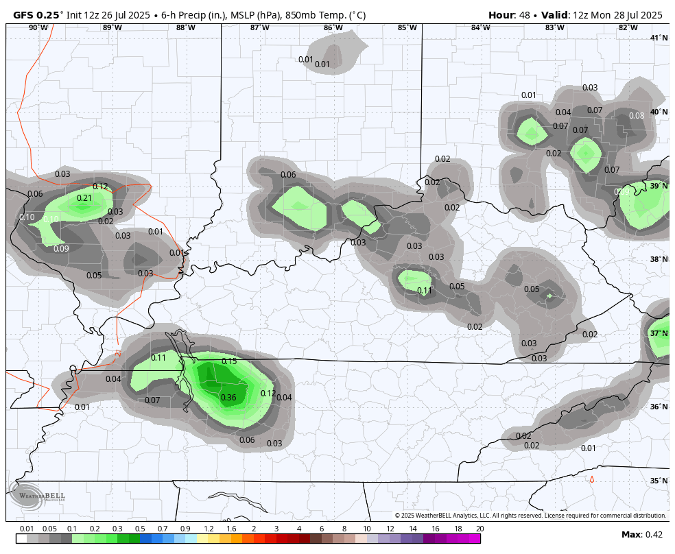
Scattered showers and storms will be noted and these carry us into Monday. One or two may be strong or severe. Locally heavy rains may also create Liam high water issues.
Storms fire up along a strong cold front dropping in to end the month.
The GFS shows all this well…
Here’s today’s Severe Weather Outlook from the Storm Prediction Center…

And here’s what that looks like to start the new week on Monday…

Much cooler air comes in behind this for a fairly pleasant start to August. Then, more showers and storms look to roll through…

Well below normal temps look good during this time. The GFS is showing some awesome temps in the first week to 10 days of the new month…
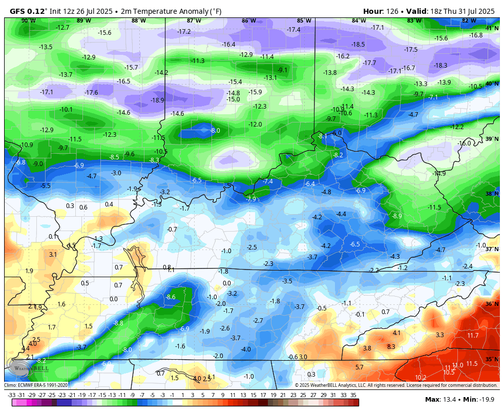
I won’t be complaining about any of that!
I leave you with your full complement of Sunday storm tracking tools…


Current watches

Possible Watch Areas

Make it a sensational Sunday and take care.

Thanks Chris. Will be glad when this ( La Nina Ridge ) of strong High Pressure moves far enough West to give us the lower Dew Points in the 50’s and 60’s degree range. Not a very good chance for Rains in my local forecast next week, so any new plantings will have to be watered.
Define “well below” normal. Unlikely that temps go very low.
https://www.google.com/search?q=What+are+the+below+normal+temperatures+for+Kentucky+in+August&sca_esv=e6a856e083a4051b&sxsrf=AE3TifMKamAntIFmqkDwTtksGm2pymOr1g%3A1753631269526&source=hp&ei=JUqGaIDZHfmuqtsP5sXSmAw&iflsig=AOw8s4IAAAAAaIZYNdrBfN_8xF8HWa4kWfho07jUEFlk&ved=0ahUKEwjA_4nHsd2OAxV5l2oFHeaiFMMQ4dUDCB8&oq=What+are+the+below+normal+temperatures+for+Kentucky+in+August&gs_lp=Egdnd3Mtd2l6Ij1XaGF0IGFyZSB0aGUgYmVsb3cgbm9ybWFsIHRlbXBlcmF0dXJlcyBmb3IgS2VudHVja3kgaW4gQXVndXN0MgUQIRigATIFECEYoAEyBRAhGKABMgUQIRigATIFECEYoAFI-qcFUABYlvkEcAF4AJABAJgBqwGgAfsrqgEFMTkuMzG4AQzIAQD4AQGYAjOgAuQtwgIREC4YgAQYsQMY0QMYgwEYxwHCAgsQABiABBixAxiDAcICDhAuGIAEGLEDGNEDGMcBwgIIEAAYgAQYsQPCAgUQABiABMICCxAuGIAEGNEDGMcBwgITEC4YgAQYsQMY0QMYxwEYigUYCsICCxAuGIAEGLEDGIMBwgIUEC4YgAQYsQMY0QMYgwEY1AIYxwHCAgsQLhiABBjHARivAcICDhAAGIAEGLEDGIMBGIoFwgIIEC4YgAQYsQPCAgUQLhiABMICBBAAGAPCAgYQABgWGB7CAgsQABiABBiGAxiKBcICCBAAGKIEGIkFwgIIEAAYgAQYogTCAgUQABjvBcICBRAhGKsCmAMAkgcFMTYuMzWgB9jvArIHBTE1LjM1uAfdLcIHCTAuMTcuMzMuMcgHuwE&sclient=gws-wizJeff, here’s some information that explains ” below normal temperatures in Kentucky for August : “
79 is forecast for Lexington next Sunday. That’s not “well below” normal.