Good Tuesday, everyone. Heat and humidity have a few more days left in the tank before we change it up in a big way. A major pattern change blows in o end July and begin August. That brings some very pleasant air into the region.
Temps out there today reach 90-95 in many areas, but the humidity levels continue to run on the absurd side. Heat Index numbers from 100-105 will be possible with western Kentucky likely going above and beyond that. 110+ heat index numbers will show up again.
The heat index numbers on Monday hit levels I haven’t seen before…
120 is now the Heat Index in Webster County in western Kentucky. That may be the highest heat index number I’ve seen in Kentucky. #kywx pic.twitter.com/f8DVY60zfj
— Chris Bailey️⚡️ (@Kentuckyweather) July 28, 2025
120 heat index numbers in Kentucky? Wow.
Looking ahead to Wednesday, temps and heat indices look to be similar to what we have out there today.
Both days will feature a few thunderstorms going up with late Wednesday and Wednesday night giving us the chance for some strong storms rolling in from the northwest. The Storm Prediction Center has parts of the region in the low-end severe weather risk…

The cold front actually shows up on Thursday and may bring a few more strong to severe storms. Here’s the Severe Weather Outlook for Thursday…

In addition to some local severe storms, the local flash flood threat will continue to be with us.
Here’s how all of this plays out on the GFS that starts Wednesday afternoon and ends Friday afternoon…

Well below normal temps sweep in from later Thursday through the weekend…
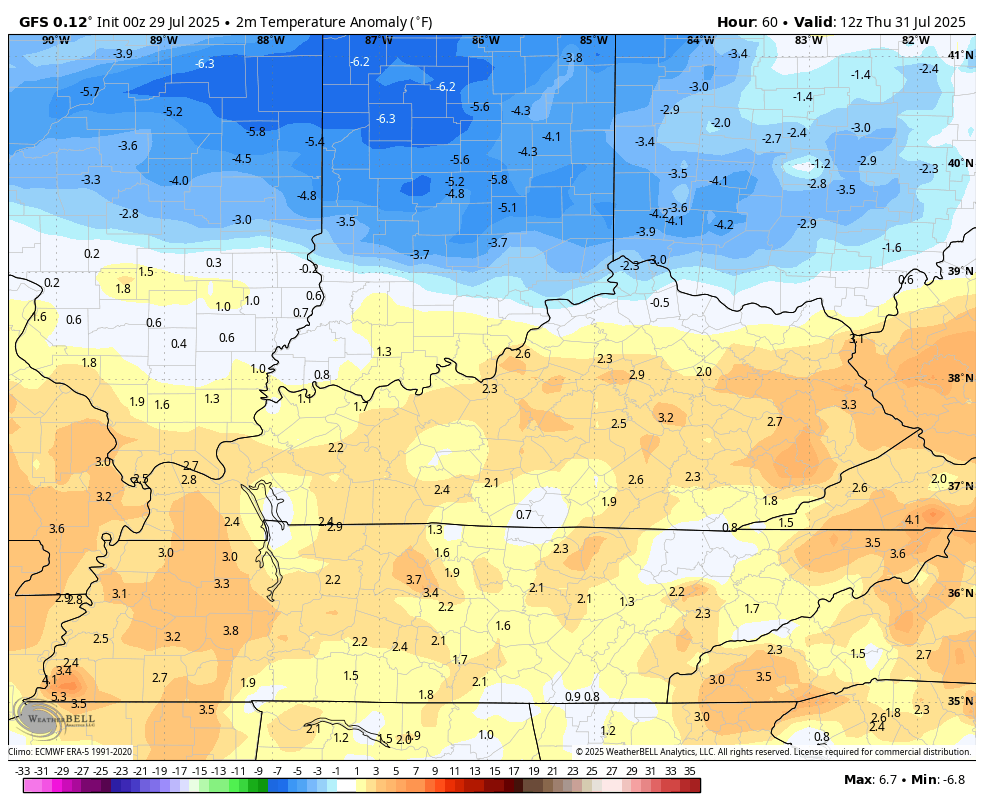
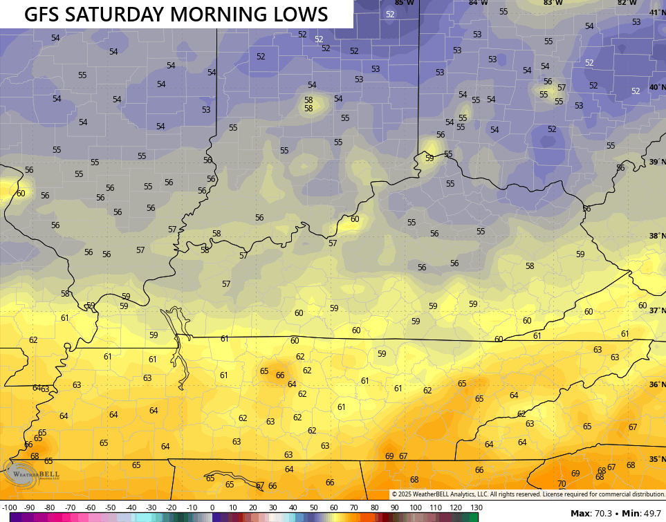
Highs Friday may not get to 80 in some areas with super low humidity levels, making for a gorgeous start to August. This sets the stage for lows in the 50s by Saturday morning…
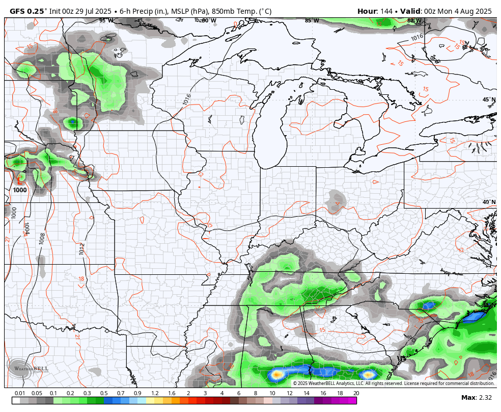
Scattered showers and storms try to get back into the mix later this weekend into early next week as temps stay below normal.
Heat builds in across the Plains again by the middle and end of next week and should fire up some healthy clusters of storms ahead of it. Those may come rolling through here…
As usual, I have you all set to do some tracking to start the week…


Current watches

Possible Watch Areas

Make it a magnificent Monday and take care.

“Well below” normal is overstating it.
Whatever it will be I’ll welcome the change to rid us of this awful humidity.
It’s not that bad.
Thanks Chris. I’ve seen some pretty horrible heat waves in my time. The worse one was in the Summer of 1976.
The NWS has issued an Extreme Heat Warning for Warren County and all counties to the west, and I expect to see the same issued tomorrow, but those conditions were most certainly in play yesterday. At 4:10 pm CDT, my PWS south of Bowling Green registered a temperature of 98.2°F. Combining that with a dewpoint of 82.3°F resulted in an insane heat index of 124°F. Last night a gust front blew through the area, which dropped 0.16 inches of rain, along with several large tree limbs. All that the rain will succeed in doing is push the dewpoint up a few more notches.
I’m si ready for a pattern change!
Joe, last evening I notice my barometer was rising, which is indicating that the high pressure is being amplified by La Nina, and is centered right over our area. I don’t know if we will ever see ENSO / El Nino again ? I’m more than ready for a weather pattern change.
I have read on another blog that some people don’t want the heat end. I guess there the ones that don’t have to be out to work in the oppressive heat and humidity that we have endured since June. I know I’m ready for a change .
I’m out in it plenty. Summer isn’t over and people can get over that.
The Sun saids that Summer is over September 23 rd. Mid- West Summer weather may not be, but the days shorter.
JEFF, you not thinking about the elderly or some people have problem breathing in this kind of weather. This type of weather we have endure has last long enough.Like you said it’s gotta end sometime looking forward to it
False and foolish take.
I’ve worked out in the heat ( in my plant nursery ) for over 35 years. Younger back then, so I didn’t mined it’s so much. Now I hate it. This Summer weather is lasting too long for this 73 year old.
After that hot summer in 1976, the Fall was very nice and colorful, and we had the coldest October on record, followed by a Cold and Snowy Winter. We were in a weak El Nino though, with a southern storm track.