Good Wednesday, everyone. We are already at the midway point of the first week of August and the pattern looks pretty similar to how the week started. A few showers and storms are working across the region today as our temps slowly get back to normal.
A small-scale low pressure continues to slowly push across the state today, bringing more in the way of those scattered storms. The action today focuses a bit farther than the Tuesday storms that created some flooding concerns in central and northern Kentucky. Today’s will mainly be across the eastern half of the state and may also produce pockets of flash flooding.
Here’s your map to follow any warnings in this area…

Isolated showers and storms will be noted Thursday and Friday into the start of the weekend as temps come back up. Normal early August temps show up during this time.
Showers and storms increase early next week ahead of another trough sweeping into the region and across the eastern half of the country. The EURO AI was ahead of all other models with the early August trough and it’s leading the charge on the one next week as well…
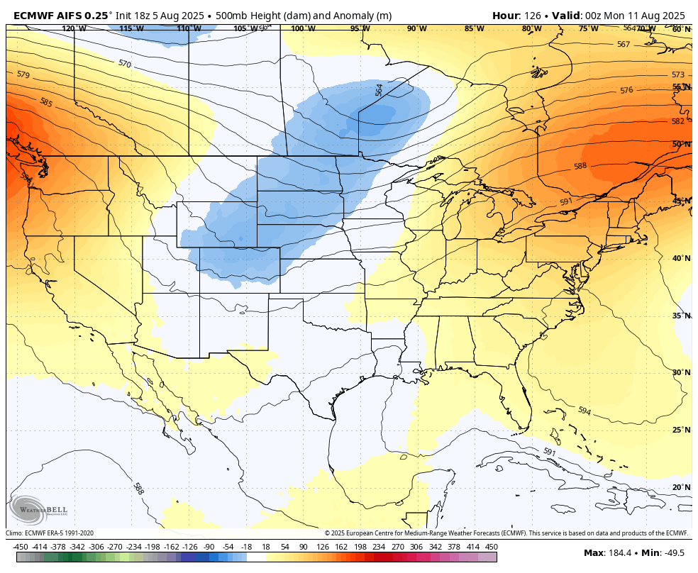
That shouldn’t give us temps as cool as what we just had, but any August trough is certainly welcome.
We are entering the time of the year when what happens in the tropics has a big impact on the overall pattern across the lower 48. The National Hurricane Center continues to watch Dexter become a fish storm with two other systems of interest…

The pattern is very likely to throw a few hurricanes toward the southeast and into the Gulf, threatening the US coast later this month into early September. I look at this pattern and wonder if we get the classic look of a big tropical system threatening the southeast as a deep early autumn trough digs into the eastern half of the country.
Here are your tracking tools for the day…


Current watches

Possible Watch Areas

Make it a wonderful Wednesday and take care.

Not buying the models hype.
Jeff at least its going back to the 90’s this weekend until next front comes through next week.
Thanks Chris. It’s looking like a typical dry August. Tropical activity in the Atlantic or Gulf will make any chances for widespread Rains in the Ohio Valley rare. Sick of Summer weather, bring on Autumn.
Autumn can wait its turn.
I think that is a given Jeff, but I like Autumn weather after Labor Day, and the beginnings of Winter weather the week of Thanksgiving.
A decent amount of rain at my house yesterday. What’s weird is that it looked like pop up, almost stationary thunderstorms on radar, only it wasn’t thunderstorms, it was just heavy rain.
Send some rain in my direction Mark. Beginning to get very dry here in Taylor county.
I don’t about you guys were having lot of foggy mornings here in my neck of woods since July. like they say the more fogs you have they say get your snow shovel out. We shall see.
Foggy morning here, and yes that is an Old Farmers forecast saying for the Winter ahead. This coming Winter, if we have ENSO / neutral, and a positive PDO, expect Snow, and if we have ENSO / La Nina, and a negative PDO, not that much Snow.
Just nonsensical folklore
That’s been said long before me and you were put on earth. There is some logical truth to it.
Discussion on Tropical Storm Dexter ( Fish Storm ) with a satellite photo. Looks like a very cloudy eye.:
https://www.weatherstreet.com/hurricane/2025/Dexter.htm