Good Monday and Happy Labor Day, everyone. We’ve made it to the start of Meteorological Fall that runs from September through November and we have another big blast of fall air ahead. This one may be accompanied by some honest to goodness rains.
August is now behind us and it was a wild month. We started cool then roasted a few weeks before sending the month out with record cold for the final week. No matter the temperature, the one constant for the month was the lack of rain. This was also record setting…
Here’s another crazy weather stat: August, 2025 goes down as the 2nd driest August on record for Lexington.
We picked up .50″ of rain for the entire month, yet we’re still 8″ above normal for the year.
August temps were also more than a degree below normal. #kywx pic.twitter.com/yF7OeJdLk9
— Chris Bailey (@Kentuckyweather) August 31, 2025
Scattered showers and thunderstorms will go up out there today across southern Kentucky while the rest of the state stays dry. Highs are back into the upper 70s to low 80s to start September.
Low pressure spins into the region Tuesday and Wednesday, bringing much better coverage of showers and storms. That will then be followed by a powerful fall cold front zipping through here with a line of showers and storms on Thursday..
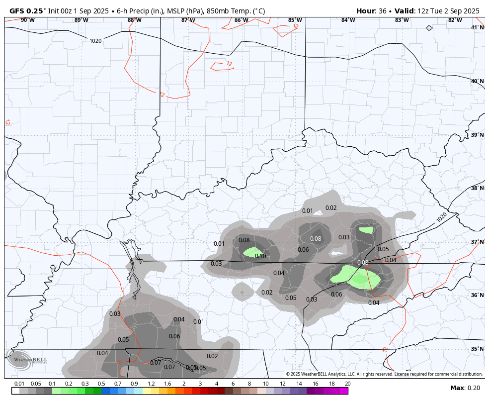
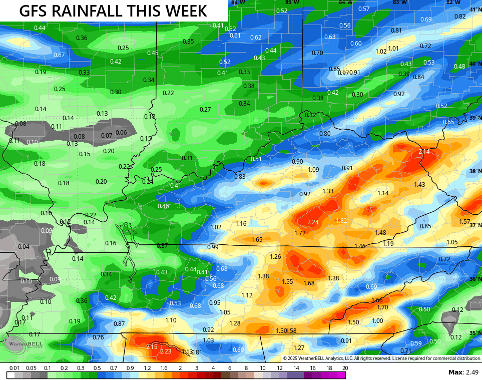
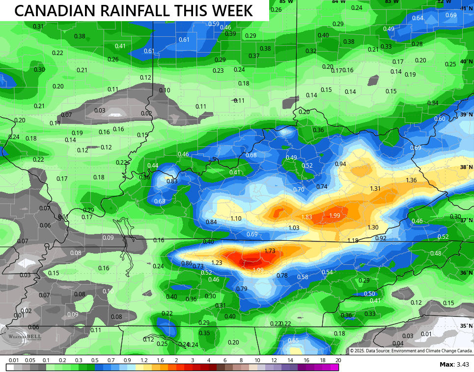
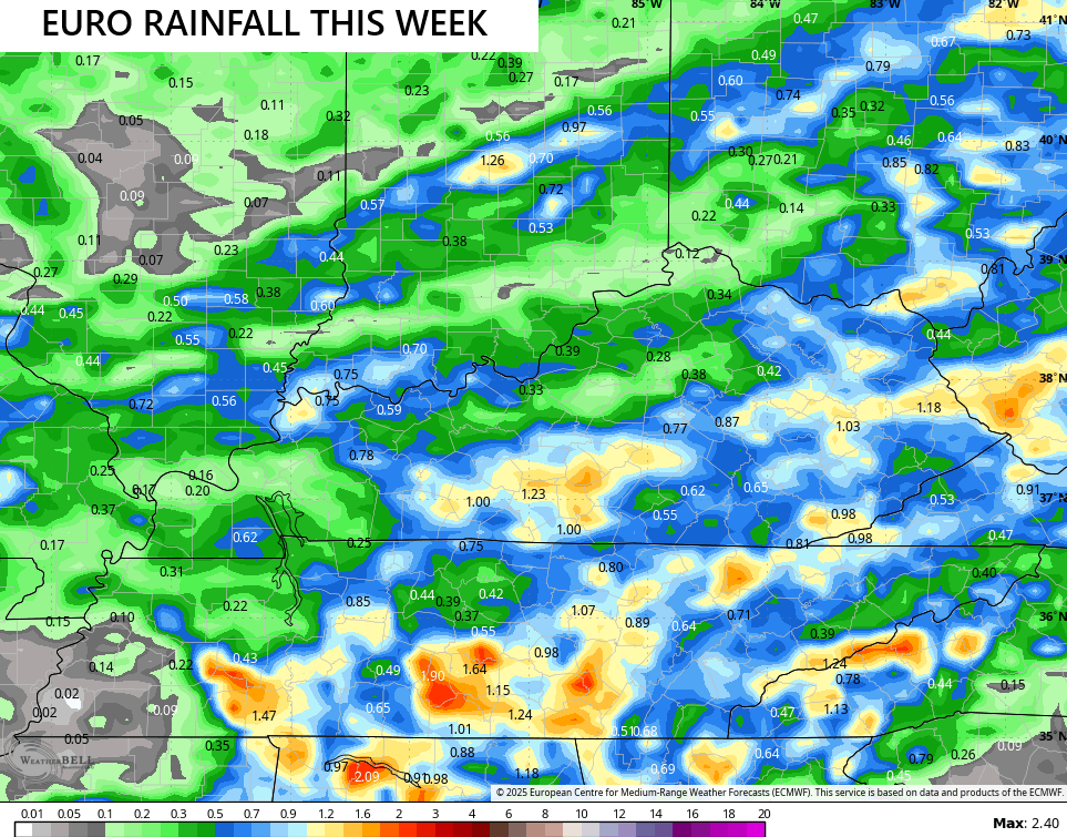
The models are spitting out some decent rain totals, especially across the eastern half of the state…
Thursday’s temps may not get out of the 60s for areas where clouds and rain hang for most of the day.
Another system arrives late Friday with a narrow band of showers and storms and brings another blast of fall for the weekend. Highs range from the upper 60s to low 70s with overnight lows deep into the 40s.
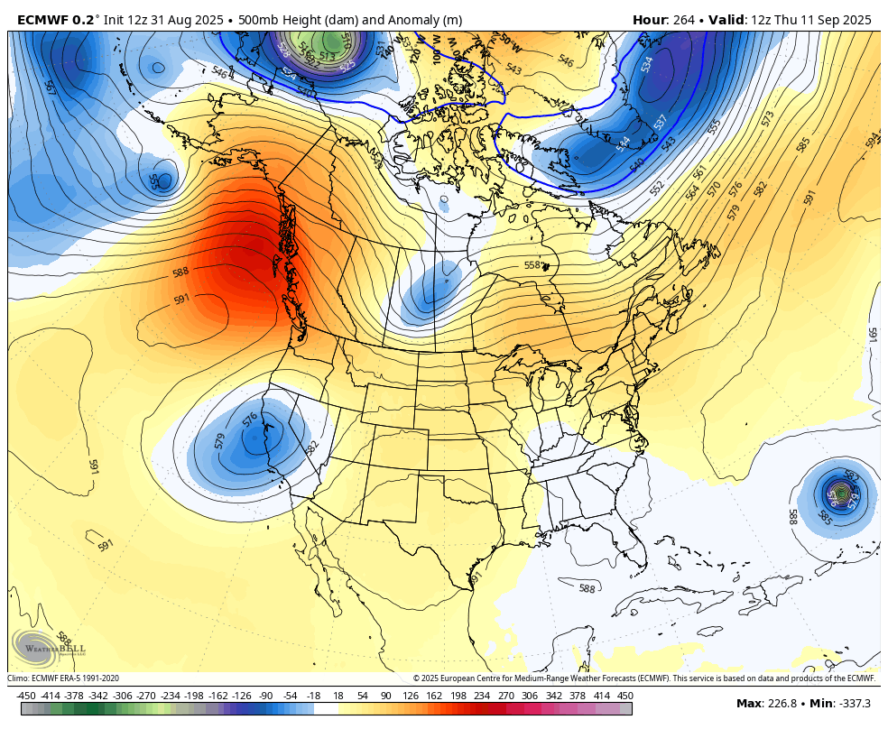
The setup for the next week and change is one most of the models didn’t really see from the medium range. They saw something, but they underestimated the magnitude of the trough and the amount of cool air with it. They also did this ahead of the late August trough and cool.
I’ve talked a lot in recent years how most models really struggle anymore with seeing cooler than normal temps and troughs, and that’s especially true with anything from the EURO family. The AI seems to be working on correcting that as it’s had a pretty good run.
The operational EURO is trying to see something in the medium range for the second week of September. Watch the trough at the same time it shows something tropical off the east coast…
The National Hurricane Center is seeing something trying to pop well out in the Atlantic in the next week…

I leave you with your Kentucky Weather Radars to track the scattered showers and storms in the south…

Have a Happy Labor Day and take care.

Call me skeptical, but I’ll believe the rain when I see it.
Thanks Chris. According to the Kentucky Mesonet at WKU, Taylor County Accumulated only 0.03 ” of Rain in the Month of August 2025. For the Year to Date 47.4 “. Driest Month I Ever Experience. Just Hope the Predicted Rains this Week come about for all Areas that Need It. Looking Forward to Another Autumn Cool Down, but in the Next Several Months, the Temperatures will Have to Balance Out.
The Tropics Have been Quiet So Far, Due to the Presistence Trade Winds, and a Drier Atmosphere Aloft. When the MJO Changes, I Expect an Increase In Tropical Activity.
I always thought the tropics was the reason for our boring weather this time of year. The weather just stays the same (outside of different temp changes) But yet, this year the tropics haven’t even been active (YET)
I think that the effect of the tropics on late summer and fall weather in our area is overdone. Also, the rainfall an area actually gets is almost always a fraction of what the precipitation model forecasts predict, at least in south central Kentucky. The prolonged lack of rainfall and low soil moisture levels in the Bowling Green area has had a direct effect on local relative humidity and dewpoint values, which is one reason why promising lines of storms seem to fall apart as they approach the BG region. That and the absence of a moisture flow from the Gulf of Mexico, resulting in some cold fronts coming through moisture-starved.
Joe, I think There is a Serious Interruption in Our Climate. The North Component and the South Component are Not Coming Together to cause Convection. The Cause could be A High Pressure System ( Extension of the Bermuda High ) Separating the Two Components for Over a Month Now.
Loving this weather and the weather coming. Anyone want to take a guess on how the upcoming winter will be????? Love to hear your thoughts.
Lets just all Hope it’s an Interesting Winter.