Good Friday to one and all. Thermometers continue to slowly climb through the weekend and this rolls into next week as Mother Nature tries to balance out our record cold start to the month. The well above normal temps will make it feel more like mid-summer here in mid-September.
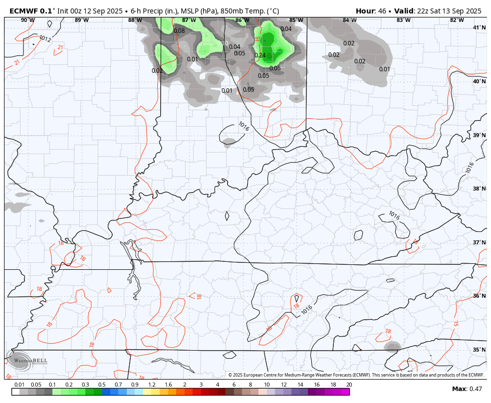
Temps today hit 90 in the west and low to mid 80s central and eastern Kentucky. Similar temps show up this weekend as the numbers bump up by a degree or two. Skies stay partly cloudy with the chance for a shower or thunderstorm going up Saturday night and Sunday. This action may drop in from north to south and may even go back toward the southwest…
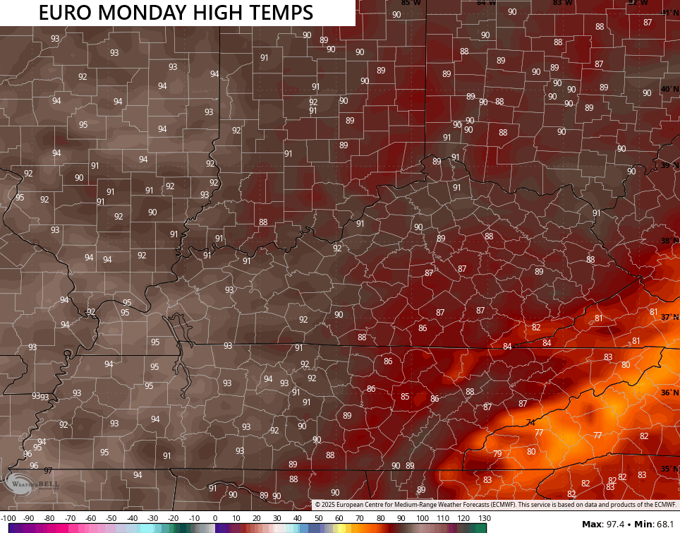
Temps by Monday get even toastier with the models in a little better agreement with the placement, but they do have notable differences in how hot things get. The Euro continues to show the south and east being cooler than the west…
The GFS is similar with this thinking, but the numbers in the west continue to run much hotter…
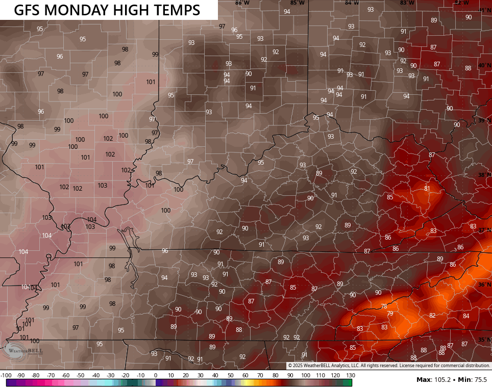
100 degree temps out west aren’t impossible, but not likely.
The air will be incredibly dry which means a heat index won’t be a big issue.
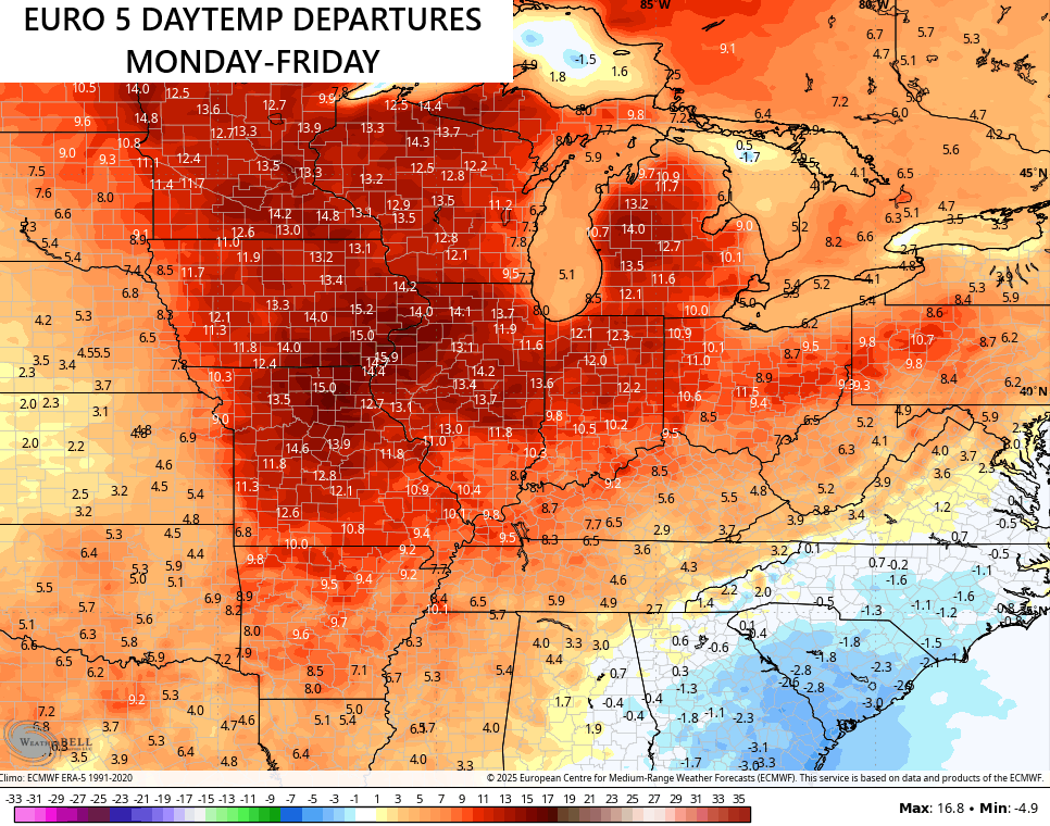
Temps from Monday through Friday of next week will be well above normal for our region, but you can see how the core of the above normal temps are to our west and northwest. Here’s the EURO…
The GFS for the same time period…
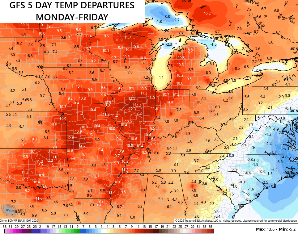
That kind of look has been common in our region this year and really for the last few years.
We have two things to watch for next week. The first is a system along the southeastern seaboard that may spin far enough west to bring some rain in here by the middle of next week. The seconf is for a couple of cold fronts to drop in from the northwest later next week into early the following week.
The EURO is the one model showing all this trying to bring us some rain. This animation starts Tuesday and goes through the following week…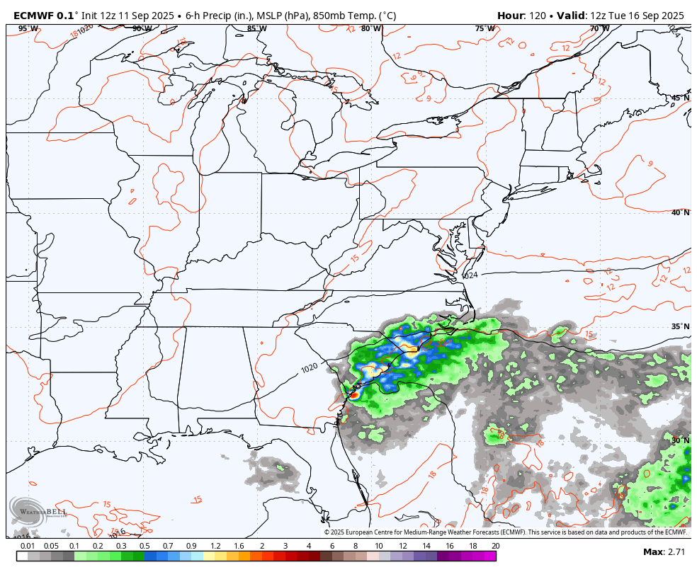
With a more active look, it would bring some beneficial rains in here…
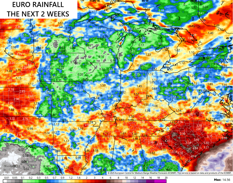
At this point, we will take whatever we can get.
The tropics continue to be as inactive as you have ever seen for this time of year. The Atlantic has one system of interest over the next 7 days…

Have a fantastic Friday and take care.

So I guess it’s NOT the tropics that causes or weather to just go straight up BORING for weeks this time of year. It’s something else.
Mark, It’s High Pressure making the weather boring. It is unusual for the Bermuda High to be this dominating this long. Our usual weather pattern will return, but no one seems to know when that may occur.
Warren County has reinstated their burn ban, which will remain in place at least through September 30th. The county had suspended the previous ban approx 10 days ago, after southern and northern areas received some measurable precip, but central Warren County only picked up trace amounts. In my opinion, the ban should never have been suspended, since the fire threat in the county’s most populace had never eased. With temps forecasted in the mid-90’s next week and low humidity, the fire threat is higher than I’ve ever seen it.
Where I live in Taylor County, there’s always a Burn Ban. If not, there should be. Lots of beautiful Forest and I don’t want to see it destroyed. A number years back, a careless neighbor, on a dry, windy March day left a brush fire burning and part of my woods. I got in touch with the fire department, and they turned it over to the Forest service to put the flamming fire out. It took 5 hours to put the fire out. Over an acre of my woods was damaged. Thanks to Mother Nature, the woods returned to it’s natural beautiful. Never underestimate Mother Nature.
Here’s a very interesting article on the Pacific Decadal Oscillation, and why it’s been at the negative phase ( La Nina ) so long. Looking like we may be slowly phasing to the warmer phase ( El Nino ) for next Winter 2026 -27. Snow lovers get your sleds ready, and keep your Snow shovels handy.
https://climateimpactcompany.com/pacific-decadal-oscillation-report-has-the-pacific-decadal-oscillation-flipped-to-positive-phase-2-2/