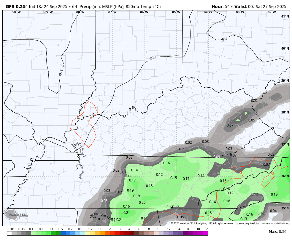
Good Thursday, everyone. Rounds of showers and storms are rolling through the state today with heavy rains likely through the first half of the day. From there, the focus of the forecast jumps to the weekend and the chance for some rain against the grain.
The tropics are threatening the east coast as well, so the overall pattern to end September and begin October looks busy.
Today’s heavy rain and thunderstorms are widespread to start, leading to the potential for local flash flood issues. This heavy rain will slow down as we get toward the afternoon with scattered showers and storms remaining across central and eastern Kentucky.
Lingering showers will be noted in the far east and southeast Friday with better weather across the west and central.
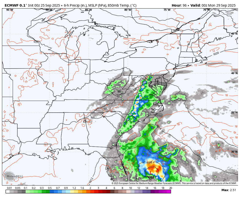
Low pressure stalls across the Carolinas over the weekend and may actually push back toward the west a bit. This would bring the threat for a few showers and storms into the east and southeast Saturday and Sunday with the potential for this stuff to work even farther west late weekend and early next week.
This is something the models have been hinting at for a while and are even more emphatic with this possibility. This animation starts at 8pm Friday and goes through Tuesday…
Exactly what happens with this system may very well determined by two possible hurricanes just off the southeastern coast.
Tropical Storm Humberto formed Wednesday and is expected to become a hurricane this weekend as it works toward the northwest. Here’s the latest from the National Hurricane Center…

Humberto shows up well on satellite, and you can also see the next system spinning just to the west…

These two systems join Gabrielle out in the Atlantic…

So what happens with Humberto and the soon to become Imelda? That remains to be seen but we may have a rare occurrence of two hurricanes spinning side by side near the east coast. The models will change from run to run with how they handle this scenario.
The EURO is bringing Imelda into South Carolina with the remnants coming all the way to Kentucky before high pressure pushes it back south. It keeps Humberto in the Atlantic…
The Canadian brings Imelda inland and leaves Humberto in the Atlantic…
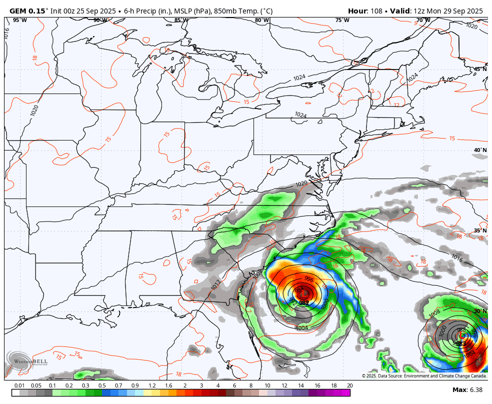
Can we actually get the remnants from a tropical system hitting the Carolinas? Maybe… But we are still a few days away from knowing that for sure.
As usual, I have your storm tracking tools for the day…


Current watches

Possible Watch Areas

Make it a terrific Thursday and take care.

It would be very rare if that action actually occurred. Warmer than normal, and below normal precipitation will most likely return for next week. As long as we have tropical activity in the Atlantic, our normal west to east progressive weather patterns will be interrupted from time to time.
Will have to wait until daylight to read my rain gauge to find out how much rain has accumulated since Monday. Just found out, 3.50.” Great start to relieving us from this more than a month old “pocket drought. “
I was surprised to see that we’d had just over 2 inches overnight. That brings my rainfall total for the week to 3.66.
Dottie, It wasn’t EHD that killed the Deer near my property. It was a Kid that was out to kill some animals for his pleasure. He has been caught and arrested. The Kids now days have no respect. Very sad what’s happening in today’s world. The good news is that we all received the much needed rains.
I’m glad that kid was caught and charged. And I agree whole heartedly about the lack of respect in our youth these days.
Thankfully we haven’t found any more EHD deer but there have been others around our area. I’m hoping the rain helps with that but I know we need a freeze for it to kill the midges.
I, too, have had significant rain yesterday and last night. There was 2” in my gauge at 11:30 pm.
We had received about 1.6 inches from Monday thru Wednesday morning.
I am in Daviess county.
Chris how far from a freeze are we by your future models?
Chris how far from a freeze are we by your future models?
I don’t think anyone knows the answer to that question. Usually our first freeze occurs around the 25th of October. Maybe later this Autumn ?
Adding this information to the above about first freeze dates :
https://www.google.com/search?q=when+is+the+first+freeze+date+for+autumn+in+kentucky&sca_esv=2e3a0442facbf014&sxsrf=AE3TifN_ki57Rf4zsKi5m_Zq04w9aNeLTQ%3A1758811940943&source=hp&ei=JFfVaI_CN-nKkPIPzbmZ2Qg&iflsig=AOw8s4IAAAAAaNVlNNagOlRHXb7Pvb8M_HHkz0ytsrav&oq=when+is+the+first+freeze+date+for+autumn&gs_lp=Egdnd3Mtd2l6Iih3aGVuIGlzIHRoZSBmaXJzdCBmcmVlemUgZGF0ZSBmb3IgYXV0dW1uKgIIADIFECEYoAEyBRAhGKABMgUQIRigATIFECEYoAEyBRAhGKABMgUQIRifBTIFECEYnwVIktcCUABYs7gCcAB4AJABAJgBxwGgAYUjqgEFMTkuMjG4AQHIAQD4AQGYAiigAu4kwgILEAAYgAQYsQMYgwHCAg4QLhiABBixAxjRAxjHAcICCxAuGIAEGLEDGIMBwgIIEAAYgAQYsQPCAhEQLhiABBixAxjRAxiDARjHAcICBRAAGIAEwgILEC4YgAQY0QMYxwHCAhQQLhiABBixAxjRAxiDARjUAhjHAcICDhAAGIAEGLEDGIMBGIoFwgILEC4YgAQYxwEYrwHCAgoQABiABBhGGPsBwgIIEC4YgAQYsQPCAhAQABiABBixAxiDARhGGPsBwgIGEAAYFhgewgILEAAYgAQYhgMYigXCAgUQIRirAsICCBAAGKIEGIkFwgIIEAAYgAQYogTCAgUQABjvBZgDAJIHBzE0LjI1LjGgB_–ArIHBzE0LjI1LjG4B-4kwgcJMC4xMC4yOS4xyAelAQ&sclient=gws-wiz
Another interesting article on what the weather pattern may be in the days ahead. Here’s the link :
https://climateimpactcompany.com/u-s-medium-range-forecast-very-warm-forecast-continues-heavy-rain-suppresses-warmth-in-the-mid-atlantic-states-2-2/
Glad to see you guys in KY getting the much-needed rains. Here in the Chicago Metro Area, it’s been a very dry September, with total rainfall only around .70, and no rain predicted for the rest of the month.
After such a cool start to the month, with several nights down in the 40s, we have had two straight weeks of above-normal temperatures, and the next five days are predicted to be in the low to mid 80s under sunny skies. Gorgeous early Fall weather for sure, and great for hiking to see the leaves starting to change color in the nearby forest preserve.