Good Friday to one and all. We’ve made it to the end of the week with the final weekend of September kicking off on a pretty nice weather note. Looking ahead, we have to watch the eastern sky, especially with twin tropical troubles off the southeastern seaboard this weekend and early next week.
Before we look ahead, let’s look back at a soaker of a week here in Kentucky. The Kentucky Mesonet shows widespread 2″-4″ rains with locally higher amounts…
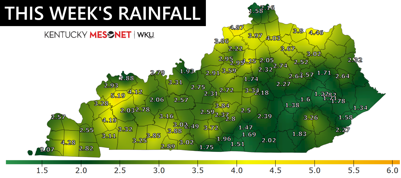
We gave you notice this was on the way and the forecast from nearly a week out verified nicely…
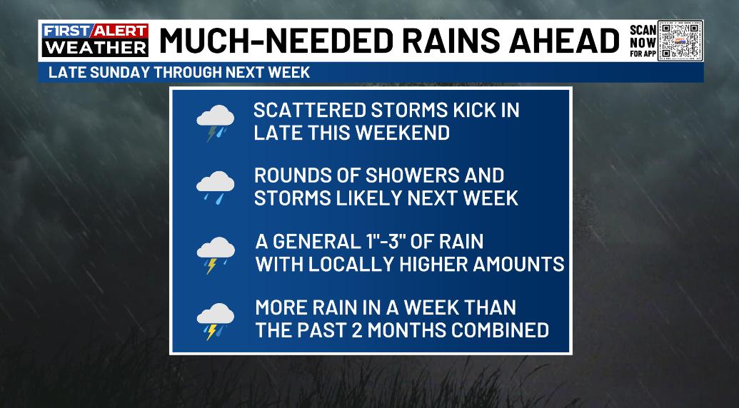
Reminder that’s an old graphic and not the forecast for the upcoming week. haha
Temps today are in the 70s for most of Kentucky with the slightest chance for a shower or storm in the southeastern corner of the state. That’s the same area to watch for a shower or storm this weekend as moisture tries to spin in from the east.
Much of what happens early next week will be dictated by Humberto and, especially, soon to be Imelda. These storm systems are spinning not too far from one another right now…

Humberto doesn’t look like a threat to the east coast, but the soon to be Imelda does as it forms near the Bahamas…

As mentioned, Humberto will likely stay far enough off the east coast to preclude any direct impacts…

Let’s focus on Imelda and the threat it poses to the southeast coast. The latest spaghetti plots from the various hurricane models really like a South Carolina landfall…
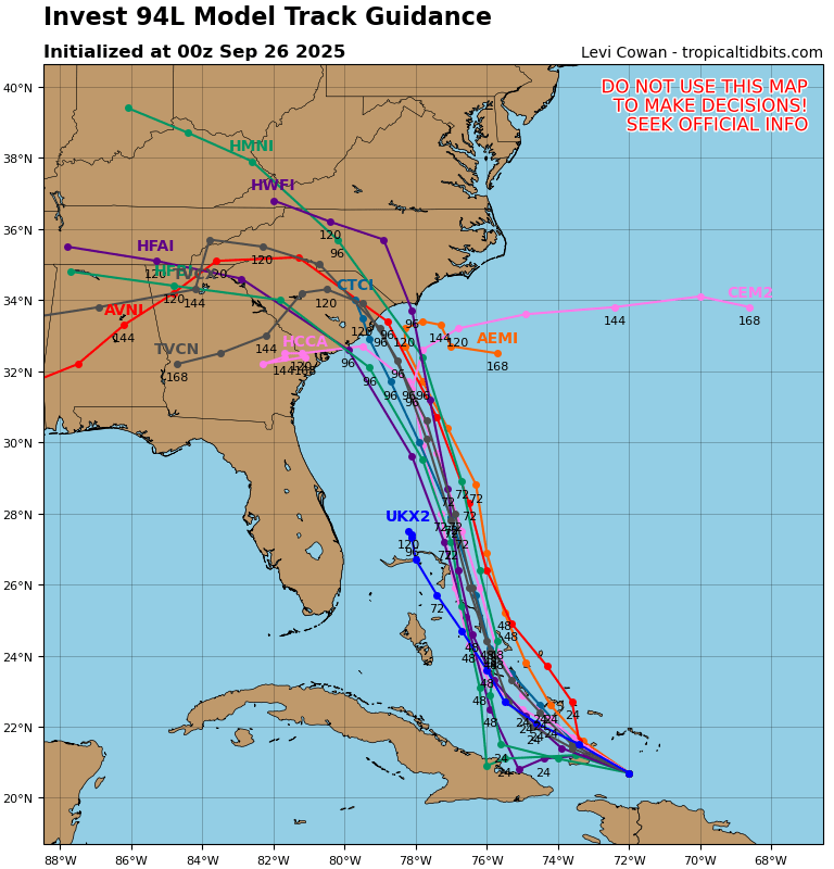
You notice how several of those bend the inland track far enough west to potentially impact our weather with some rain. While that’s certainly not a given by any means, the potential is there for this system to bring some moisture in here by Tuesday or Wednesday of next week.
Two of the better hurricane models like this idea as well.
The HWRF looks like this…
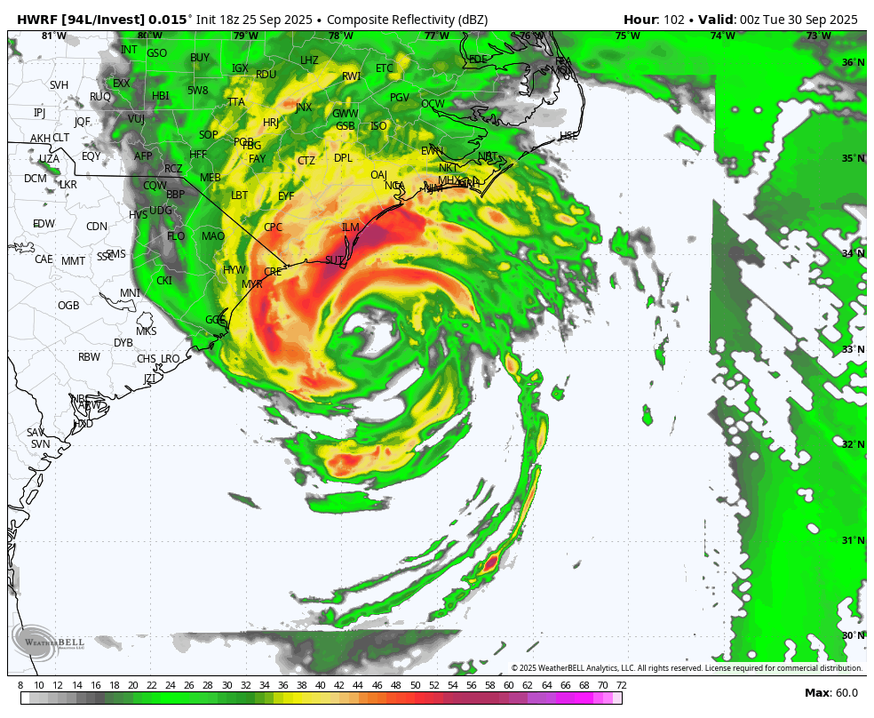
The end of that run shows rain pressing into Kentucky from the east.
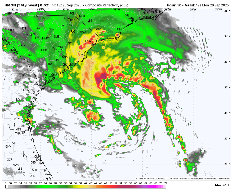
The HMON takes it even faster and farther west into our region…
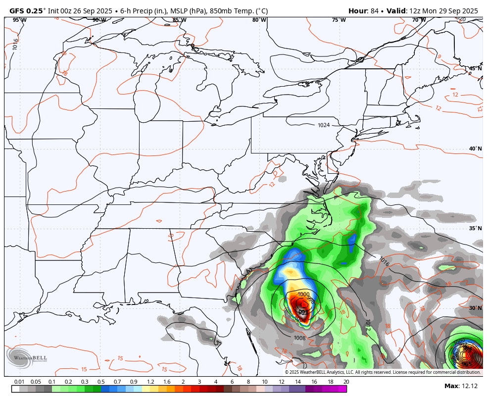
The operational models such as the GFS and Euro have been hinting at this potential for a few days now and continue to do so. Here’s the GFS…
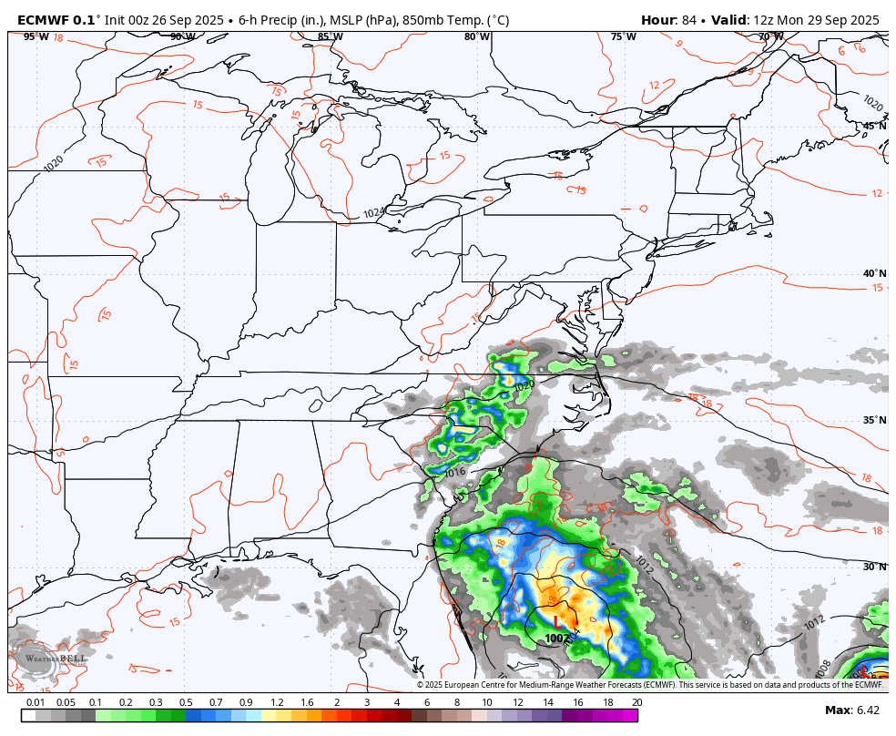
The Euro is a little slower with the whole setup and even stalls Imelda near the coast before looping it inland as Humberto gets out of the way and leaves it alone…
We are still a ways away from knowing if Imelda even makes landfall or if it can impact our weather. But… There’s certainly the chance we can get some rain out of this.
Here are your isolated shower and storm tracking tools for the day…


Have a fantastic Friday and take care.

Thanks Chris. Great job in your forecasting this past week. Here at my location, we received 3.75 “of much needed rains. I am very concerned about what may happen in the coming days. If the Tropical Cyclone moves in a Westerly direction, there could be a Catastrophic Flooding event. As with all weather events it’s still a potential. I am particularly concerned about the Southeast part of the state of Kentucky.
Here’s a link that explains what may happen :
https://www.google.com/search?q=fujiwara+effect&sca_esv=70a532a702b7bdb6&sxsrf=AE3TifOpVqoP-1PDTFLjxJaXTJePJd7uJQ%3A1758880620103&source=hp&ei=bGPWaImaBPGYwbkPgtzT2QI&iflsig=AOw8s4IAAAAAaNZxfD4YTcK6UrF3-R7lsY2zmpOWTXBt&oq=Fujiwar&gs_lp=Egdnd3Mtd2l6IgdGdWppd2FyKgIIADILEAAYgAQYsQMYgwEyCxAAGIAEGLEDGIMBMg4QABiABBixAxiDARiKBTIFEC4YgAQyDhAAGIAEGLEDGIMBGIoFMgsQLhiABBixAxiDATIIEAAYgAQYsQMyBRAAGIAEMg4QABiABBixAxiDARiKBTIEEAAYA0jndlAAWIU-cAB4AJABAJgBoAGgAaEGqgEDMi41uAEByAEA-AEBmAIHoALSBsICCxAAGIAEGJECGIoFwgIREC4YgAQYsQMY0QMYgwEYxwHCAgoQABiABBhDGIoFwgIOEAAYgAQYkQIYsQMYigXCAhMQLhiABBixAxjRAxhDGMcBGIoFwgITEC4YgAQYsQMYQxiDARjlBBiKBcICEBAuGIAEGLEDGEMY5QQYigXCAgsQLhiABBjHARivAcICEBAuGIAEGEMYxwEYigUYrwHCAg4QLhiABBixAxiDARjUApgDAJIHAzAuN6AHzkuyBwMwLje4B9IGwgcFMi02LjHIByU&sclient=gws-wiz
I’ll give Chris his just due on the forecast, but I’ll always be a model skeptic. I think we get some tropical moisture. 🙂
After two months with virtually no rain, I will admit to being skeptical about last week’s precipitation models, which forecasted total accumulations in Warren County this week to exceed 4 inches. I was surprised (and grateful) to see that during the Sunday through Thursday period, my PWS recorded 4.65 inches of rain. If I had made an audio recording of my brown, crucnchy lawn, we would probably have heard it slurping up this badly needed rain!
Intensification chances for both Humberto and Imelda appear good, since sea surface temperatures in the area are significantly above normal. Those areas are also experiencing minimal shear, which are winds that rips the top of a storm away from its lower portion, and disrupt the mechanism that a tropical system uses to draw heat from the ocean surface. A region of moderate shear just inland of the southeast shore will negatively impact Imelda as it approaches the coast, especially if the shear area extends into the coastal waters.
Glad that you and Schroeder got good rains.
Thanks Jeff, it got pretty dicy for a while.
We will just have to wait and see what happens Joe. A common phrase when it comes to weather patterns.
Thanks Jeff.