Good Tuesday, everybody. Low pressure is rolling through the state today and it’s bringing a lot of rain with it. A corridor of several inches of rain is possible, leading to the potential for local high-water issues.
We are likely to see a southwest to northeast corridor of 1″-4″ of rain showing up. While the exact placement of this is a gametime decision, the latest from the Weather Prediction Center is highlighting much of the state for excessive rains today…
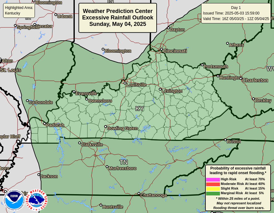
Local stream and street flooding is possible with the core of the heaviest rain and storms. This action looks to taper off from northwest to southeast this evening and into Wednesday morning. That’s when temps come way down behind the fall cold front blasting through here.
Winds will be gusty with temps likely 65-70 for many on Wednesday. The air turns really dry and that sets the stage for lows to hit 40-45 by Thursday morning with the chance for a few upper 30s in the colder valleys…
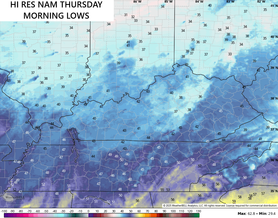
Highs Thursday are mainly in the mid 60s for many with the numbers pushing 70 in the west. Mid 60s to low 70s will be common this weekend for highs with lows reaching the 40-45 degree range with pockets of upper 30s on clear nights.
Skies are mainly dry as the system I thought could impact us now looks to set up to our east. That may touch off quite the storm along the east coast…
The tropics are popping and will continue to do so in the coming days…

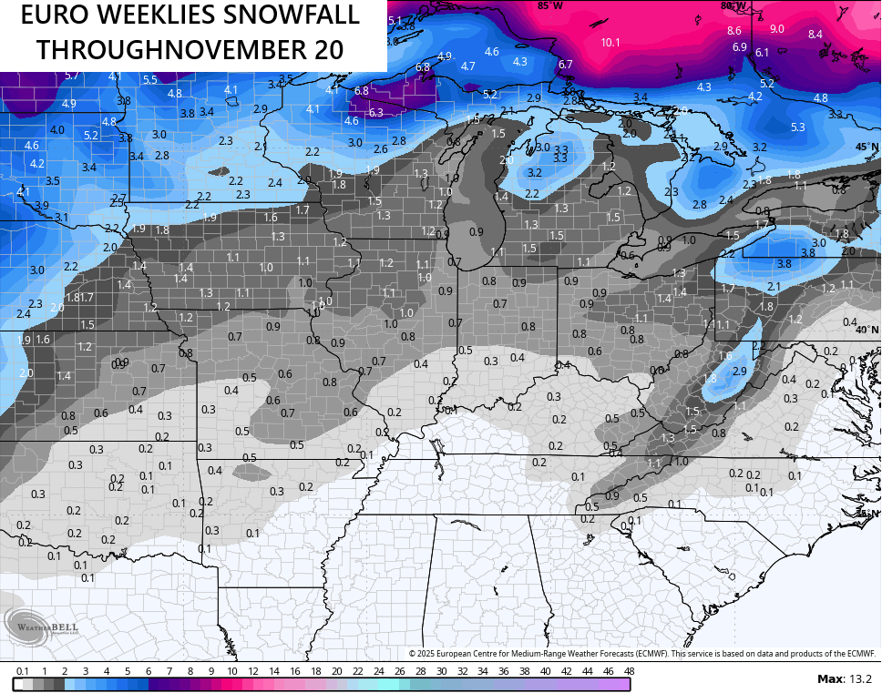
For you winter weather lovers, we are getting closer to your season, so I’ll be ramping up my look into what’s ahead. I like the idea of November snow chances once again this year, similar to last year.
The EURO Weeklies also like this potential. The latest snow map goes through November 20th and shows some flake chances…
I’ll drop by for another update later today. Until then, I have you all set to track today’s heavy rain producing showers and thunderstorms…


Make it a terrific Tuesday and take care.

Festive flakes in November if lucky.
Won’t happen here where I live. In the past 17 years, never seen a flake of Snow in the month of November. In fact, I have never seen a very impressive Snowstorm here in South Central Kentucky. My last Snowstorm I experience was at Christmas time, 2004 where 2 feet of Snow accumulated in Vanderburgh, County Indiana. Seems like anymore, all the widespread rains and major Snowstorms occur along and North of the Ohio River. The areas that receive the major Snowstorms in Kentucky are in the Northeastern and Southeastern mountain areas.
Chris, Everyone, sounds better than Everybody. Think about it.
Not the good soaking rains this morning, that was predicted, except along the Ohio River, but every low presure system has it’s dry slot. Look at the radar.
As we’ve come to expect in south central Kentucky, the bulk of the rain shield has set up to our north and west. Meanwhile, trees in the region continue to turn ahead of schedule. The dominant color seems to be a drab brown, while some drought-starved trees have already dropped nearly half of their leaves.
We are now getting some good rain showers on the back side of the low pressure system, they are heavy, but short lived showers. Will check the rain gauge, when the rain event ends, and report my total, with a comment.
Joe, the main tree species in the Forest around the home is the Tulip Popular. A tree that is not noted for Fall color, the second tree is the Red Maple. This year the trees were under a lot of drought stress, so a lot of leaf loss is present. We have a lot of different Oak species that look normal, so maybe some color to come. We need a good frost to get it started. No frost is indicated in the six to ten day outlook. I think the Autumn weather (frost) is going to be very late this season, due to climate change.
I’m not expecting a very interesting Winter for several reasons, that I have recovered. I plan on studying areas of the CONUS that receive the most major Snowstorms. The lee side of the Great Lakes if it gets cold enough, and other areas way North of the CONUS, where it’s Snowing already.
Correction: Uncovered not recovered. I miss spell words, and often use words that don’t apply. I think it’s those two minor strokes I had some years back, or that I’m 74 years old next month. LOL…
Rains over. Here in Maple we had about an inch of rain. Won’t do much for ending the serious drought, but will water plants for a week, and keep the fire danger away for awhile. I wonder how long the next rain event will take place. Seventies to eighty degrees for high temperature the next few days, is not Autumn weather in my book. Weather here is just not interesting.