Good Saturday and welcome to the weekend. It’s a day featuring more of the good stuff as the pattern continues to spit out some very nice fall weather. Subtle changes show up next week with a bigger change lurking after that.
Before we look ahead, let’s look back at a crisp Friday morning…
It was the coldest morning of the young fall season with temps hitting the mid and upper 30s in several locations. Here are the top 10 coldest lows from the Kentucky Mesonet. #kywx pic.twitter.com/RA12GLfQBx
— Chris Bailey (@Kentuckyweather) October 10, 2025
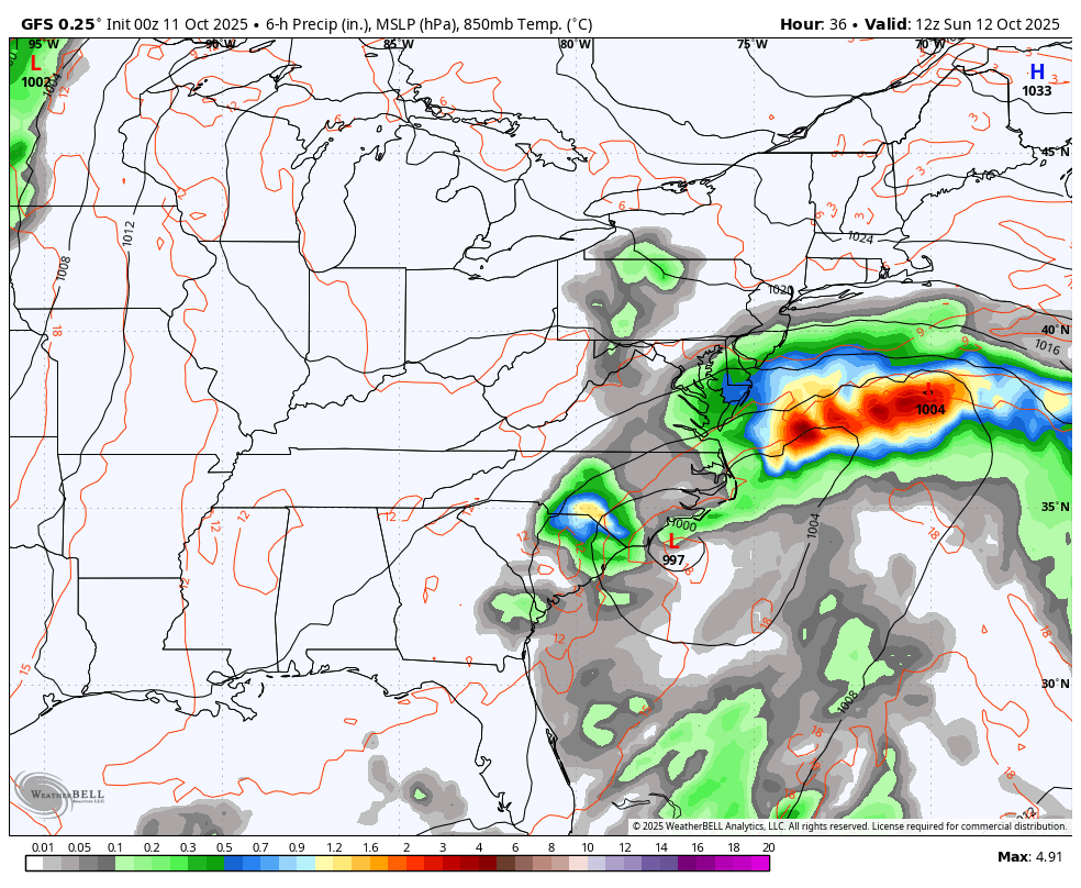
Temps today range from the upper 60s to low 70s for many and that trend takes us into Sunday. There’s still an outside shot for a stray shower getting into the southeast on Sunday, but the east coast low looks to stay just that… An east coast low.
Temps are low and middle 70s early next week ahead of a weak cold front dropping in here on Wednesday. The models are going back and forth on how far south this thing can get as the brunt of the chill with this is through the Great Lakes and New England.
Still, this has the look of a mainly dry backdoor cold front…
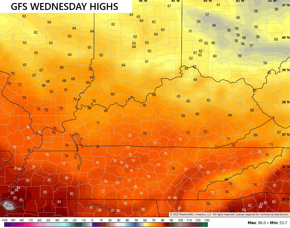
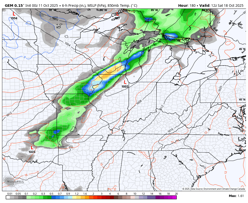
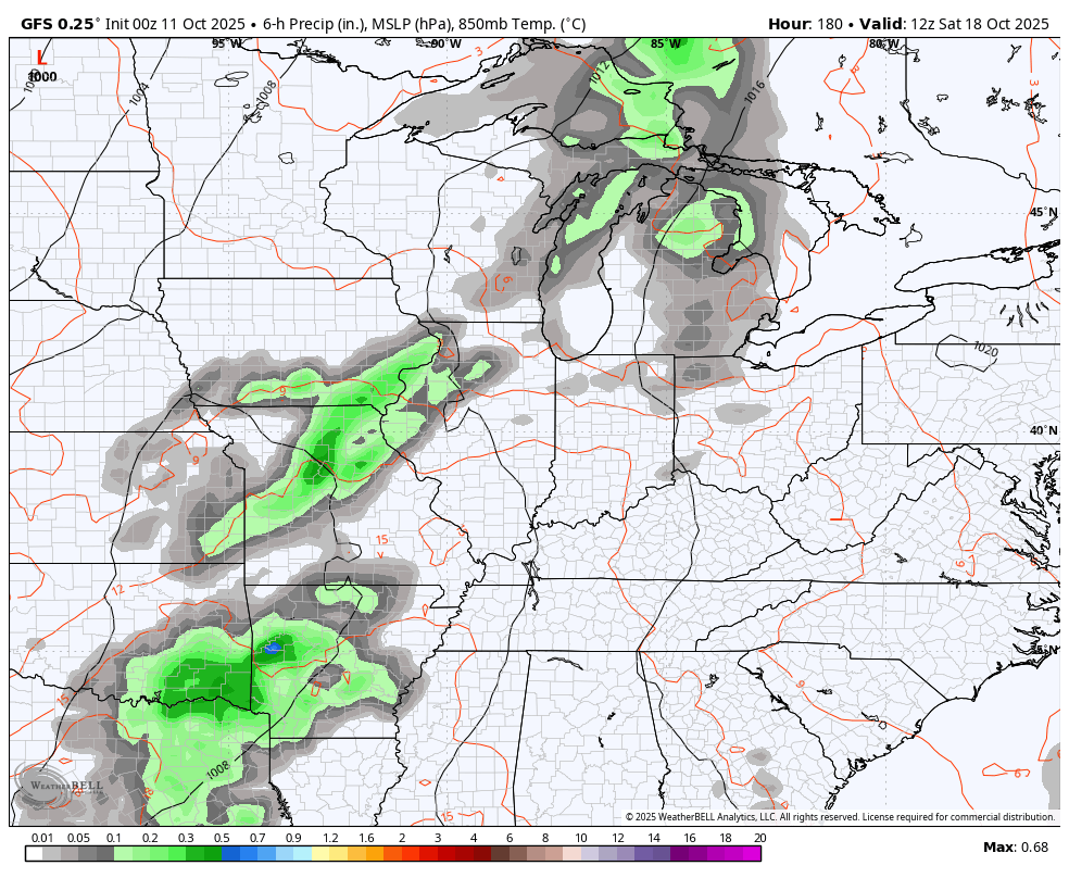
You can see how some of this chill makes its way into Kentucky, especially in the central and east. Check out the highs ahead of this front on Wednesday…
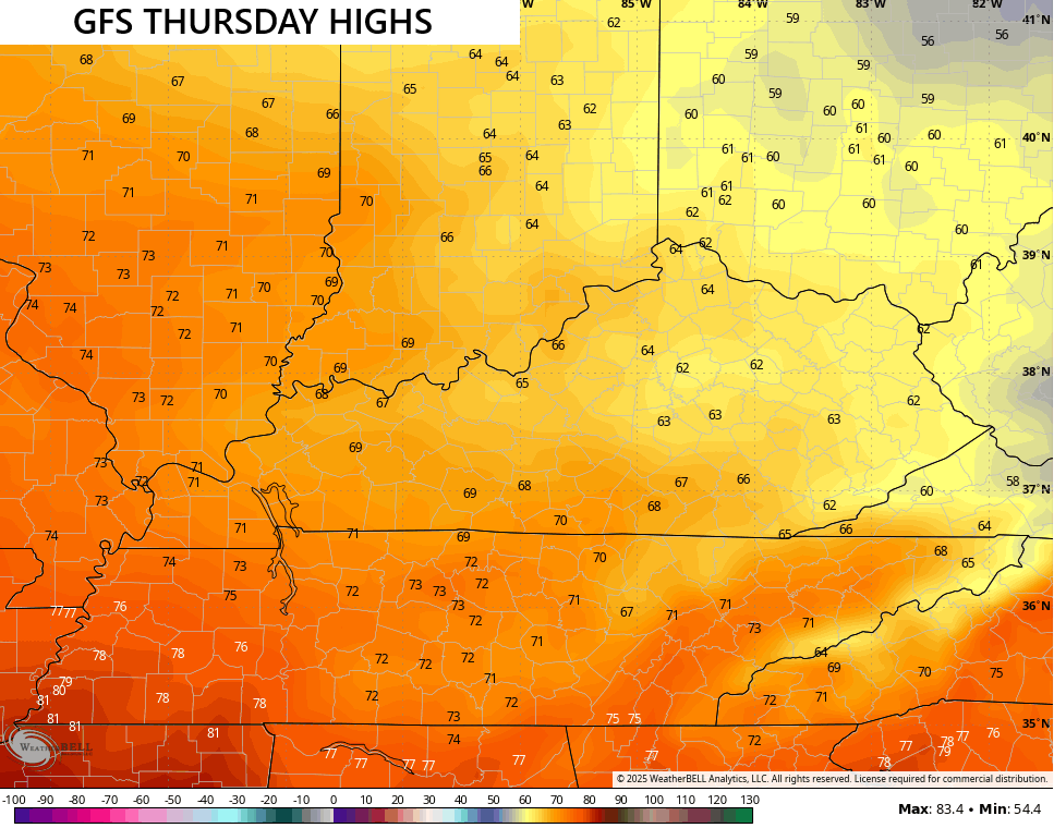
 Now look at how far those come down for Thursday…
And into Friday…
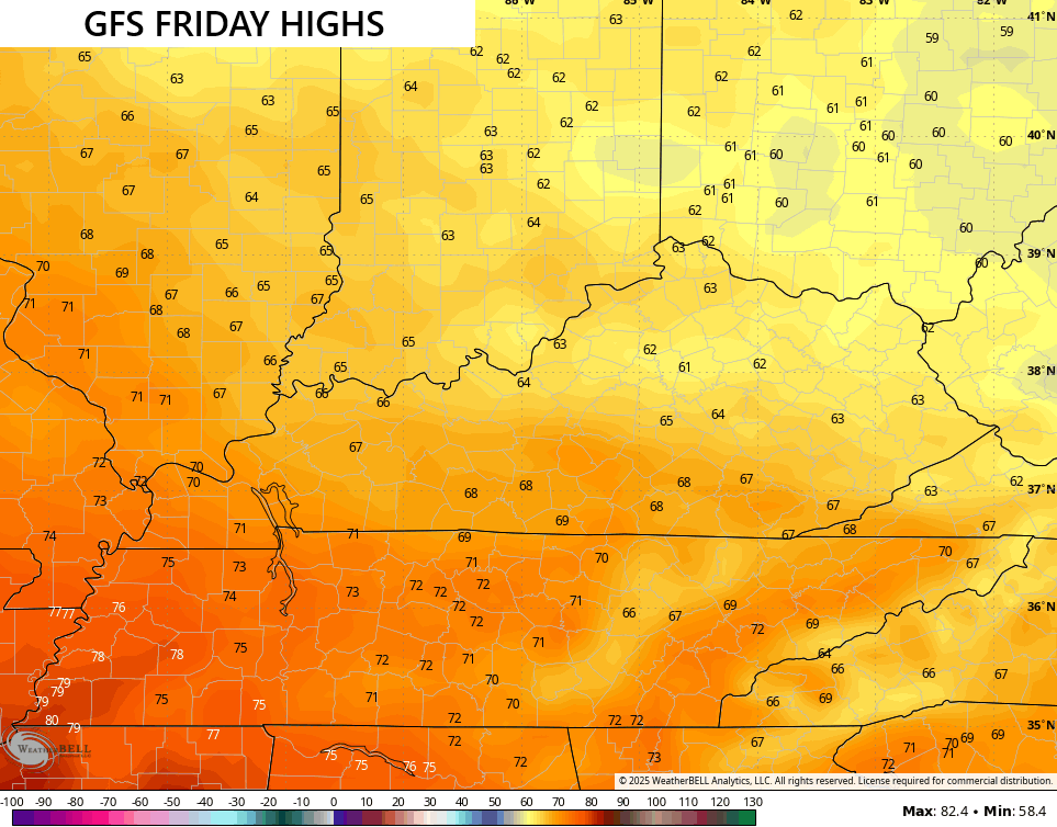
Lows can sneak into the upper 30s late in the week if this front does indeed have just enough of a southward push to it.
The pattern after this looks active with a couple of storm systems spinning through here from late next weekend into the following week. Temps ahead of these systems can really jump up and this could set us up for some strong storms. Behind these systems, things can get really chilly.
Here’s the EURO showing two big cold fronts…
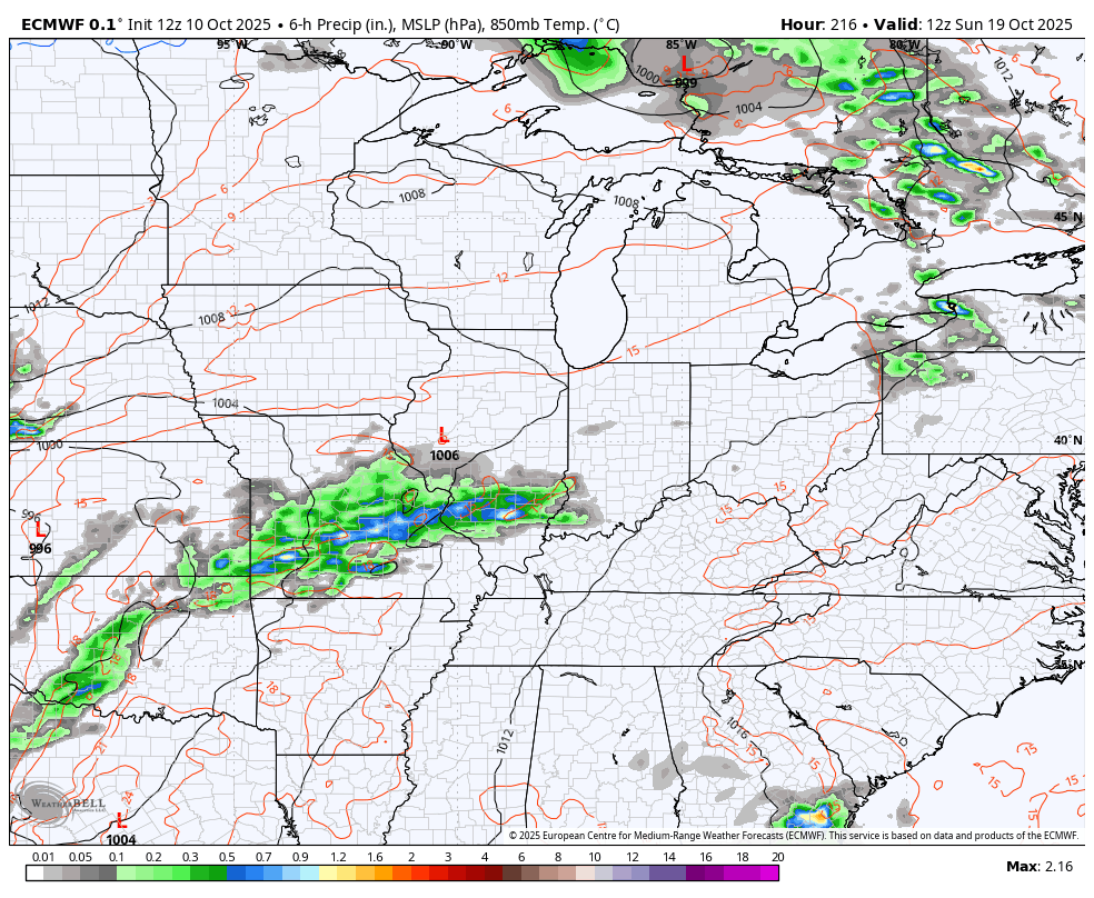
That lead system is one to watch as it could kick off the 2nd severe weather season from the Plains into our part of the world. The Canadian has a pretty wound up system…
So does the GFS…
The signal is there for a much deeper system lurking for the final week of October and that’s something to watch.
Make it a sensational Saturday and take care.

I don’t know if I’m just not remembering in the 29 years I’ve lived here, but I don’t ever remember the pattern being like this: Dead calm for weeks, then a brief period of rain, then dead calm for weeks again, then record rains, then dead calm again.
Mark, Seasonal changes are not occurring, as they have in past years. I notice this back in 1979. I have followed weather patterns very closely since I discovered Meteorology back in year 1960, when I was 9 years old. I believe we are entering the ” End Times “. I remember the statement : ” One won’t know the seasons, for the changing of the leaves. “
Thanks Chris. Dry, North Pacific Air, is “chilly”, but not like the Polar cold fronts we use to receive in the early Fall month of October. These fronts would travel farther South, and would bring those frosty mornings, and the first freeze towards the end of the month, that would start the second phase of Fall in early November. The earliest accumulating Snow ( 4 inches ) was on October 30th where I lived before moving to Kentucky. Can’t recall the exact year, except it was before the turn of the century. When will you start discussions on what we may expect this coming Winter. Really interested in your thoughts.
Here’s proof that Man Made Climate Change is accelerating, for you Jeff, and others who are interested :
https://www.edf.org/climate/9-ways-we-know-humans-triggered-climate-change?ub_tg=372&ub_o=26&ub_cta=4&ub_f=m&utm_source=google&utm_campaign=edf_none_upd_pmt&utm_medium=ad&utm_id=1741131679&gclsrc=aw.ds&gad_source=1&gad_campaignid=22327163712&gbraid=0AAAAAD9QDCx1VIIqoq70G9kLCth_p5XTK&gclid=Cj0KCQjwgKjHBhChARIsAPJR3xcbp9qn6tGpfaDE4cbSe_4sCju1-XfZA5HjO0faDAH5s7WpdVEkxJAaAi3CEALw_wcB
One of my theories, why the Caribbean and Gulf were void of Tropical Cyclone activity this year, is because the Sea Surface Temperatures are so warm that the upper layers of the atmosphere became too warm for storm development.
Not buying it.
Why Jeff ? I don’t believe I said anything wrong. If I did please correct me.
Regardless of whether we say human influenced versus natural cycle, the data shows that the average global temperatures are rising, and are affecting many aspects of our weather. Worldwide ocean water temperatures are reaching all-time highs, most recently including the Gulf of Mexico. As the upper layers of the oceans warm water, sea surface evaporation increases, directly impacting relative humidity and dewpoint levels, which in turn provide additional fuel for storm growth, on land and at sea. There have several instances this year where warmer ocean waters have caused tropical system to experience rapid intensification, in a couple of instances a tropical storm increased to Category 5 strength in a 24 hour period.
Great information Joe, I learn a lot from your comments. Keep them coming.