Good Friday to one and all. We’ve made it to the end of the week and we’re rolling into the weekend on a very pleasant note as high pressure flexes on us. Some changes finally show up as we get into next week with the potential for bigger changes the following week.
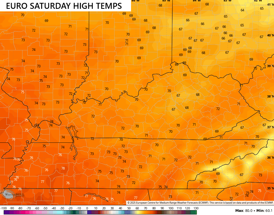
Some folks wake up to a touch of frost this morning, mainly in the valleys, as temps reach the upper 30s to low 40s. This sets the stage for another great day with highs in the upper 60s to low 70s with a mix of sun and clouds.
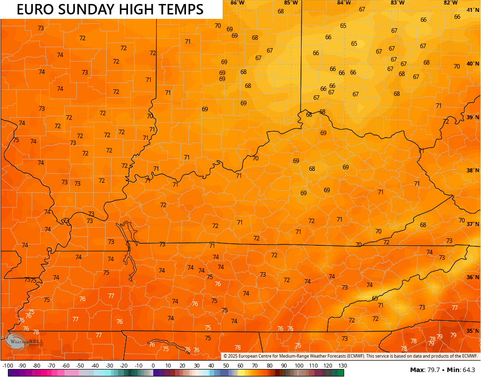
A few clouds will filter in over the weekend as temps stay awesome. Upper 60s to low 70s will be the rule for central and eastern Kentucky with 70-75 in the west…
Temps come up a bit more early next week as we await the arrival of a cold front surging in here by the second half of next week. This is coming behind that monster storm crawling up the east coast…
Canadian
GFS
If you’ve been reading KWC over the past several months, you know I’ve talked about how my number one analog for the winter ahead. The similarities on a global scale are certainly there and we are seeing some similar looks to the start of fall. Look at the temperature anomalies across the country for this September…
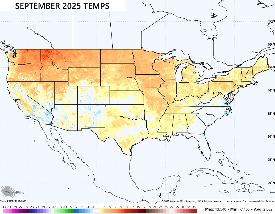
That’s almost a carbon copy of the same map from September of last year…
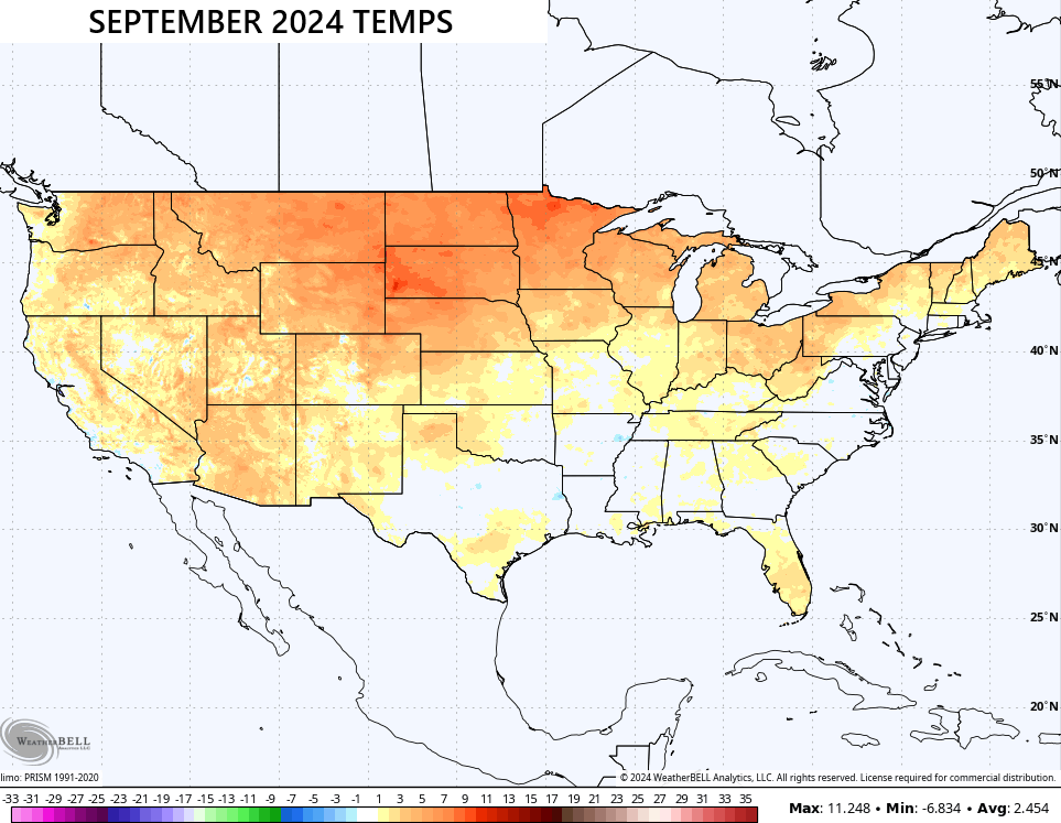
That’s pretty wild.
Enjoy your Friday and take care.

Thanks Chris. Not interested in another La Nina Winter. No Southern component to combined with the Northern component to make a “real deal ” Snowstorm, coming out of the Southern Rockies into our area of the CONUS. With ENSO / La Nina in place, we will be lucky to have Snow flurries from an Alberta Clipper System, but there may be phasing along the East Coast to make a Nor’easter. The question is : When will we have a Winter, that features a weak ENSO / El Nino ? With a positive PDO. It seems over the past years, this scenario has gone by the wayside, due to Man Made Climate Change.
The weather today is absolutely perfect, about as good as it gets around here. Last September, we may have had simular temperatures to this year, but we had more Tropical activity, coming from the remnants of Hurricane Helene. The weak or moderate La Nina, that is forecast to occur again this Winter season, could feature : Cold and dry, mild and wet, or warm and dry. All the Winter weather ( Snows ) will be along the Northern States into the Northeast States, as they will be North of the La Nina jet stream. The Lee Shore Cities of the State of Michigan could have some very heavy Snow events, as well as the State of West Virginia, and other areas of the Appalachian Mountains.
From September 26, 2024 archives :
https://kyweathercenter.com/?p=66459
The Climate Prediction Center has issued a La Nina advisory. Low level winds over the western and east central equatorial Pacific have switched to easterly, upper level winds have turned westerly, and the Southern Oscillation index was positive, which verify that La Nina is in effect. The CPC also stated this will be a weak La Nina, which will continue through the first part of winter, but there is a 55% chance that we will transition back to ENSO-Neutral during the February-March time frame. Unfortunately, years when we transition to ENSO-Neutral in the Spring most often see an uptick in severe weather during the period.
https://www.ospo.noaa.gov/products/ocean/sst/anomaly/
Also, notice in the Sea Surface Temperature Anomaly chart that water temperatures off the mid Atlantic coast are much above average, which may cause that east coast storm to show significant strengthening over that area. Not a “bomb cyclone” but close to one.
Joe, All the Climates around the World are not the same, as we older Folks once knew. I would like to see a map of all the Sea Surface Temperatures 74 years ago, and compare them with Sea Surface Temperatures as of now. I’m going to look for information, to see if it’s available.
This is all that I could fined. They couldn’t give the data back in 1951. I get the feeling that they are not going to let us know.
https://www.climate.gov/news-features/understanding-climate/climate-change-ocean-heat-content
It figures that they don’t have data before the year I was born!
What’s most worrisome about the data is the percentage of heat energy stored, taken as an average from the sea floor. The implication is that the warming is going on at all levels, and at some point it will affect the deposits of frozen methane hydrates on the sea floor, which release methane gas. This already happening in parts of Arctic Ocean and other areas scattered around the globe. Since methane is about 25 times as potent a greenhouse gas as compared to carbon dioxide, its release from methane hydrates could seriously amplify atmospheric warming.
Climate change is natural, Schroeder.
Very much agree Joe. I don’t believe our climate will return to the times, when we had pronounced seasonal changes.
Where would anyone find that statement true Jeff ?