Good Monday to one and all. It’s the first work week of November and it’s looking to be in pretty good shape in terms of the weather. Changes show up by Friday as a cold front sweeps in from the northwest. That opens up the gates to a shot of winter to follow late next weekend into early next week.
Some fog starts our Monday with nice weather to finish. This sets the stage for a nice period of weather from Tuesday through Thursday with 60-65 degree high temps common.
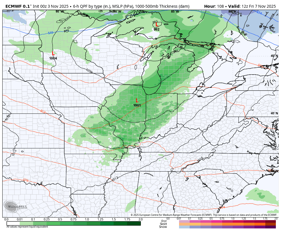
A cold front moves in later Friday with gusty showers and even a few thunderstorms. This initial front doesn’t have much cold air to work with, but the one coming in behind it Sunday and Monday most assuredly does. This is a system that has the CHANCE to bring the first flakes of the season to parts of Kentucky, epecially across the east.
The models are, as expected, a work in progress from this far out, but they continue to have the signal.
This animation from the EURO starts with the Friday front and ends next Tuesday morning…
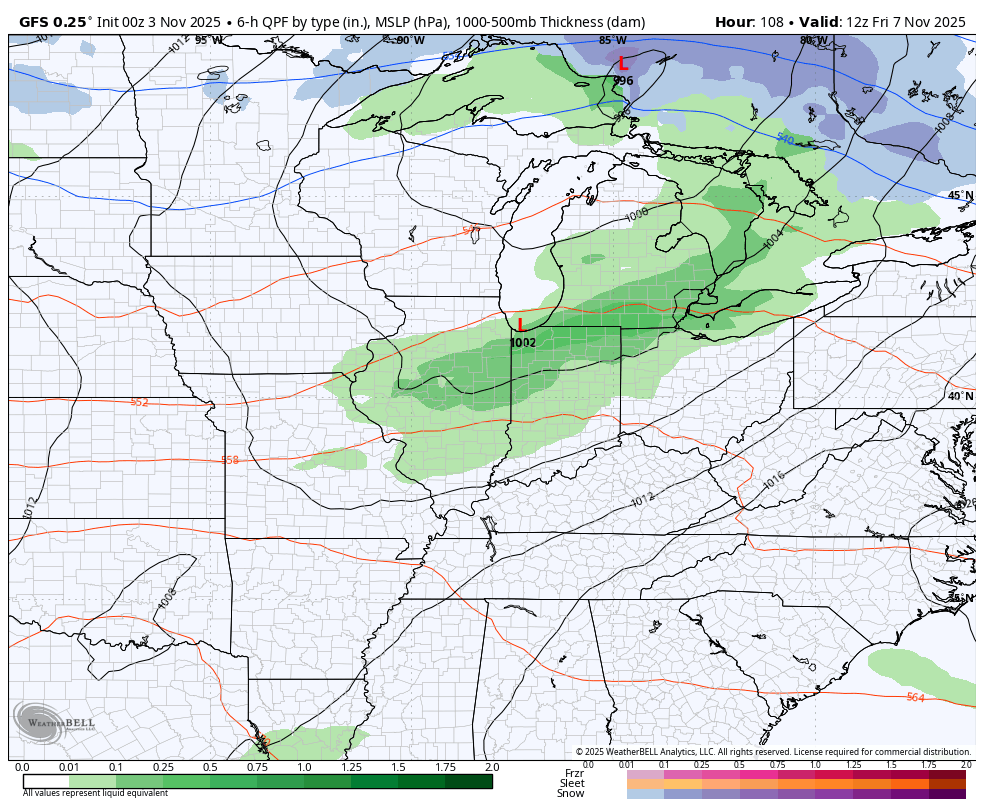
The GFS during the same time period…
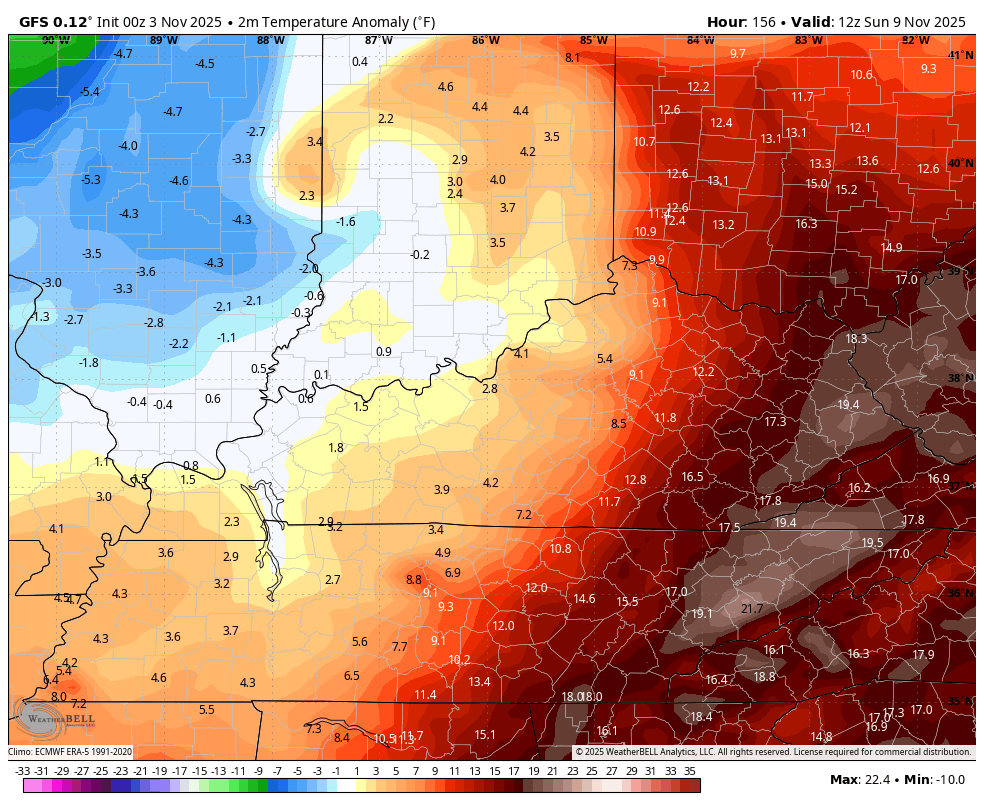
The air coming in behind this is pretty darn cold for this early in November as the numbers go well below normal. Watch the Barney colors show up in this temp departure animation that starts Sunday morning and ends Tuesday morning…
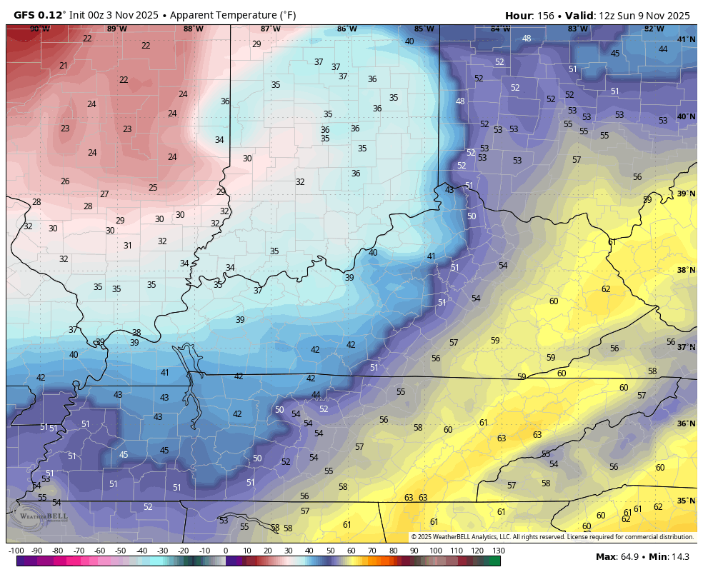
Wind chills look to be a big player starting later Sunday. Watch the wind chills tank behind this front from 8am Sunday to 8am Monday…
For a few days, the coldest air relative to normal across the Northern Hemisphere looks to be on top of us…
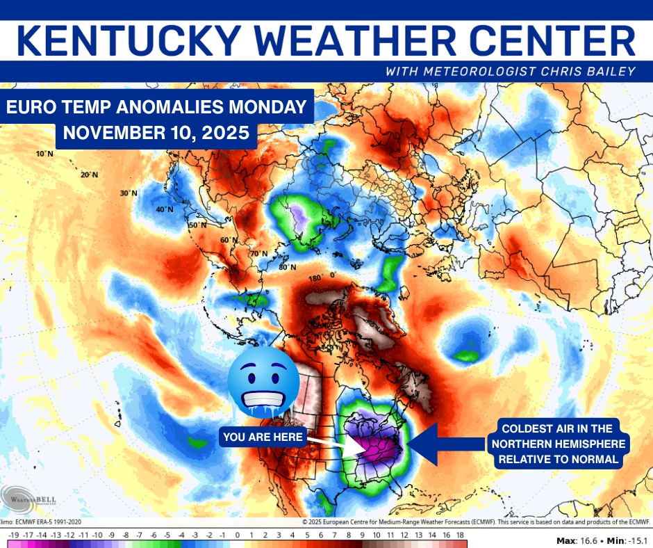
If you recall, we saw this several times last winter and we even saw it with the record cold in late August and early September.
While the pattern is skewed toward a wicked back and forth look through the week before Thanksgiving, the pattern looks to turn to one that will feature deep troughs digging into the eastern half of the country to end November and go into December.
The pattern in the Pacific looks to go toward a -EPO and a -WPO during this time. Those two look to become the overall drivers of the early winter pattern and those are signals that are typically good for winter weather lovers around here.
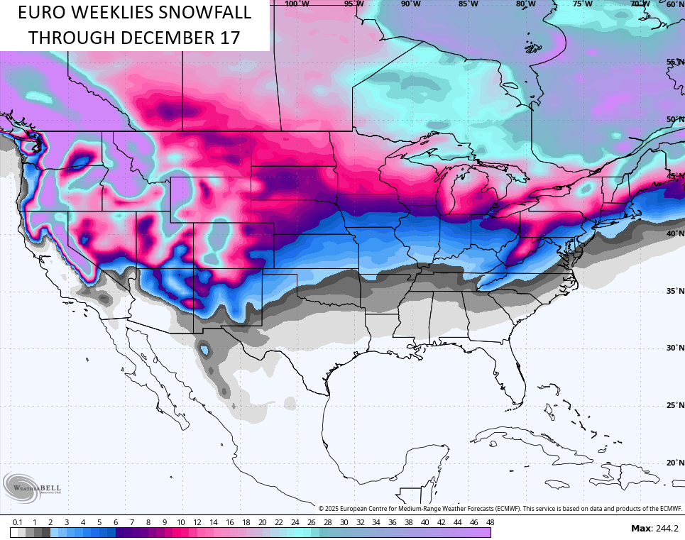
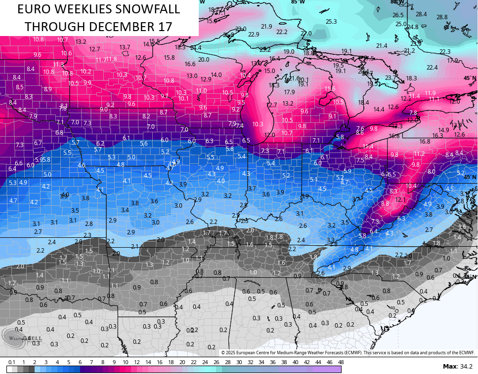
The EURO Weeklies don’t see cold and winter weather very well from weeks out, so when they look the part, we should pay attention. I’ve been showing you guys different runs from the Euro Weeklies of late and that signal continues to be fairly strong.
The EURO Weeklies are comprised of 101 members so whatever we see is an average of those 101 members. Here’s a look at the EURO Weeklies snowfall potential into the middle of December…
As I put the finishing touches on the winter forecast that will be out on WKYT in a few weeks, I’m struck by just how similar the Pacific Ocean is right now compared to the same time last year. Check out the current state of the Sea Surface Temperature Anomalies right now…
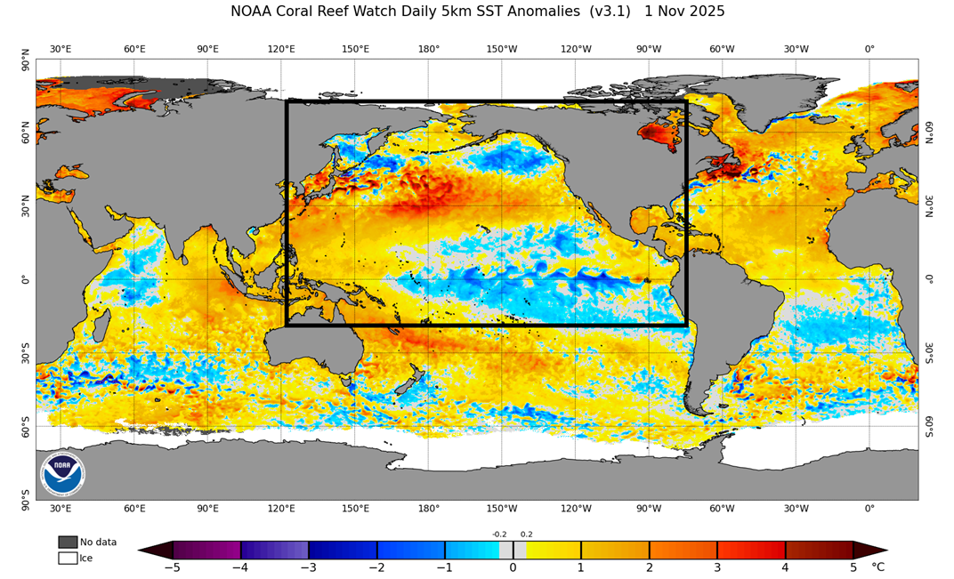
Compare those to last year at the same time…
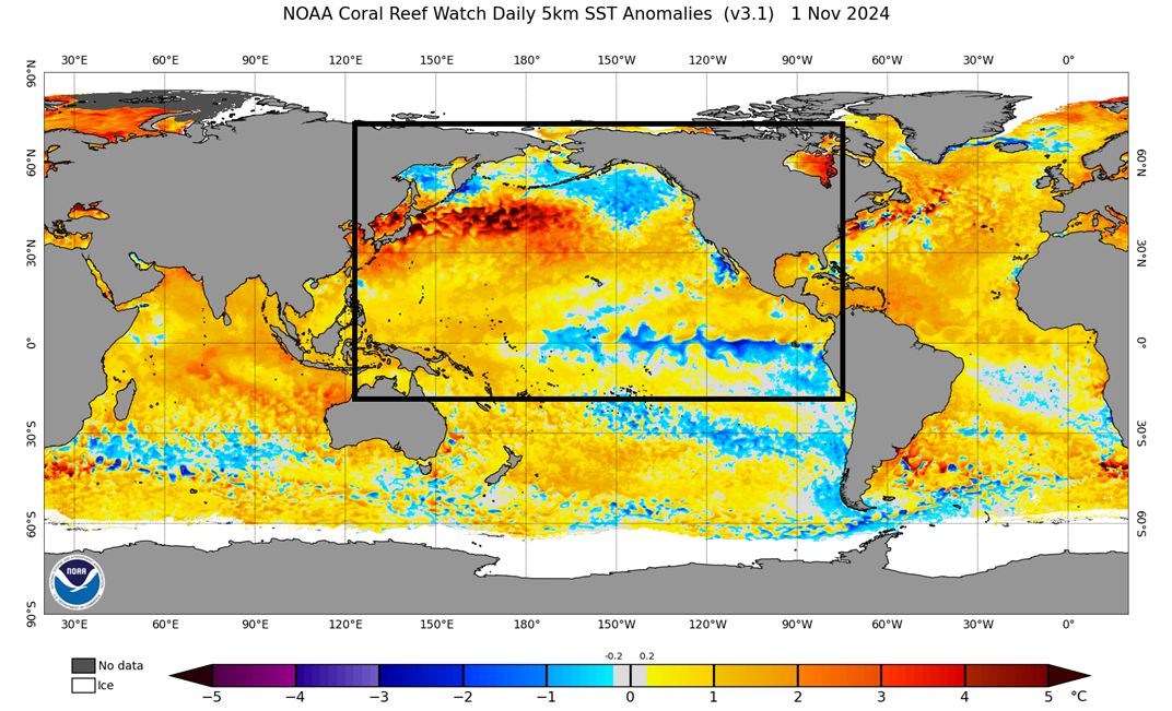
That’s pretty wild and shows why I’ve had 2024 as the top dog on my winter forecast analog list for months now.
I will have update things later today and on my Meteorologist Chris Bailey Facebook Page.
Make it a magnificent Monday and take care.

I’ll be glad when the mild weather returns. I had enough of the chill. I always looked forward to Fall and Winter and the Snowstorms that may occur, but as I get older I prefer the milder weather. Not as painful as the cold weather, and I like the lower heating bills.
Schroeder, it’s looking more likely that mild weather will be the exception, not the rule this winter. Climatologist Judah Cohen, whose area of expertise is the polar vortex is tracking several trends like late fall Siberian snow pack and stratospheric warming, which seem to indicate the likelihood of a PV intrusion in the December to late January time frame. This could occur as a single PV event, or more likely would be a series of “stretched polar vortex” conditions and would indicate a front loaded winter. If so, it would line up with Chris’s thinking that the upcoming winter will be front loaded, as well as his selection of 2024 as his primary Winter Weather forecast analog year. With a weak La Nina forecasted to phase into ENSO Neutral during the late winter-early spring time frame, it appears likely that the Ohio and Tennessee valleys will be facing above normal severe weather this spring.
Joe, I’m hoping that we will have more mild Winter days than cold / frigid days. La Nina often brings that to areas south of the jet stream, but no two La Nina’s are alike. We shall see. Worried about severe weather in our area, as we phase into ENSO / neutral later in the Winter /Spring. El Nino should be making an appearance sometime late next year. I hope this time around, the PDO goes positive. Will make the weather here in Kentucky more interesting.