Good Thursday, everyone. It’s another nice day across Kentucky but that’s about to end. Our upcoming weekend is about to take a walk on the wild side with strong storms to start and snowflakes to end. Buckle up, kids.
Let’s start with the Friday threat for a few strong to severe storms. This doesn’t look like a widespread event, but some pockets of damaging winds may show up across, especially, central and eastern Kentucky.
I’m expecting a broken line of showers and storms to approach the Ohio River by the middle of the day. This line rolls southeastward fairly quickly and will intensify from the Bluegrass Region and southwest. That line then surges quickly through eastern Kentucky during the evening.
The Storm Prediction Center has a Marginal Risk to Slight Risk out for much of this area…

As mentioned, local wind damage is the primary player and that’s what the SPC is highlighting…

The tornado threat is low with a little greater hail threat…


This system really moves through very quickly, leaving us with a mild and windy Saturday. This is just ahead of the blast of winter weather moving in Sunday through Tuesday. Here’s a breakdown of what to expect:
- Gusty showers increase along and ahead of a cold front arriving late Saturday night and Sunday morning.
- Temps Sunday morning are in the 40s and slowly drop into the upper 30s during the afternoon.
- A few rain showers develop on the strong northwest wind kicking in.
- This northwest wind really increase Sunday night as an upper-level system slides in by Monday morning.
- It’s during this time that snow showers and flurries show up across central and eastern Kentucky.
- There’s even the chance for a coating or two, especially in the mountains.
- Flurries and snow showers wind down through the day Monday.
- High temps stay in the 30s on Monday.
- Gusty winds combine with this early season arctic air to produce bitterly cold wind chills. It will feel like the low and mid teens Monday morning and again Tuesday morning.
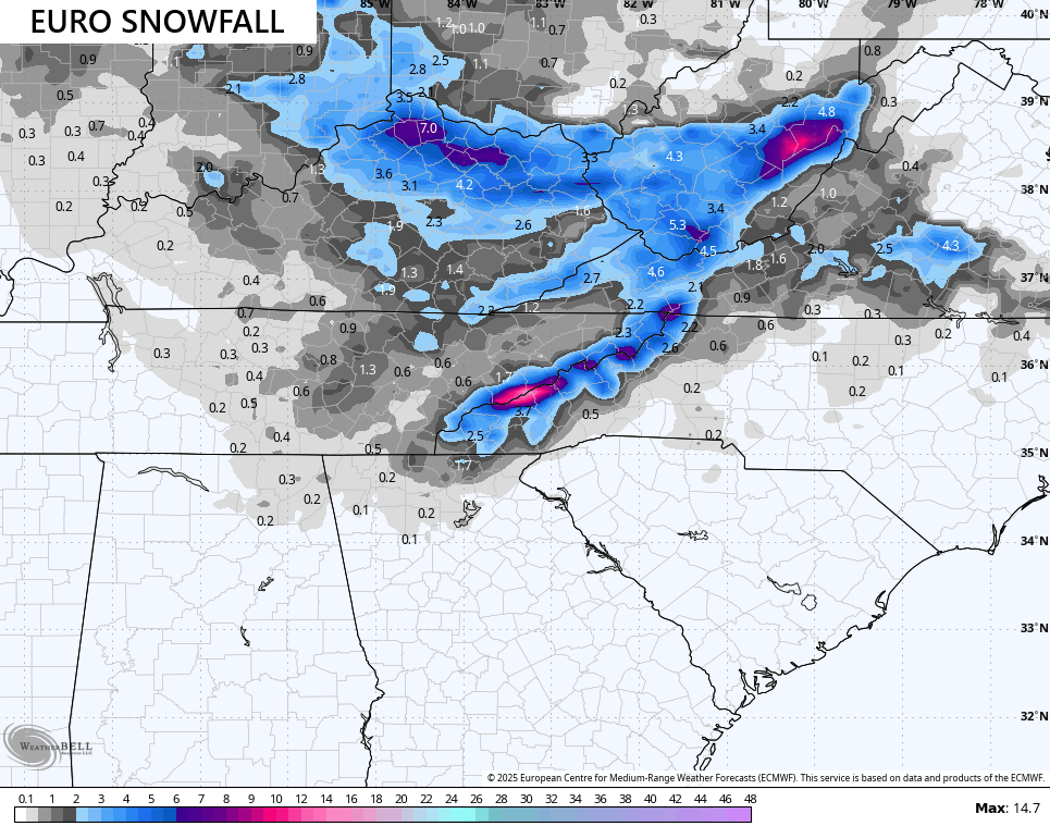
The European Model continues to be the most consistent and aggressive model with this whole wintertime scenario. It really ramps up that upper level system dropping in here Sunday night and Monday and the latest run is the strongest yet with it. This animation takes us from 7pm Saturday through Monday night…
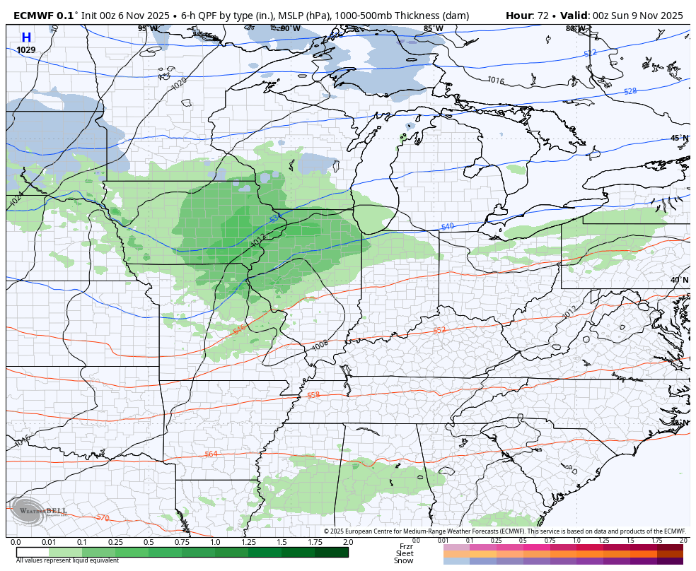
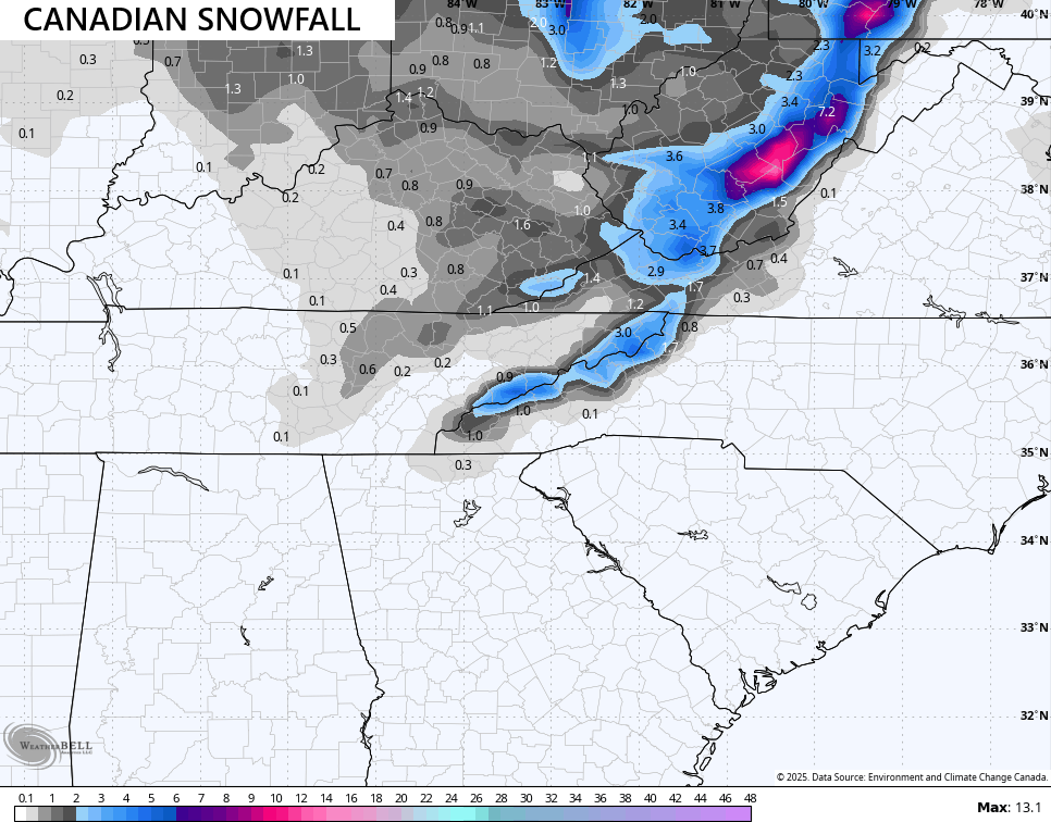
The Canadian is starting to see what the EURO is cooking up as it is also getting aggressive with that same upper level system…
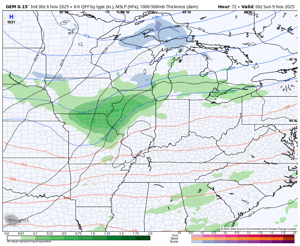
This particular run of the EURO is likely too strong with that upper level feature with is leading to the model showing a band of hefty snows from the comma head north of the track of that upper low…
The Canadian is much more tame but it is increasing from prior runs…
The ICON is also starting to pick up on the upper level feature and ramping up the snow potential…
![]()
![]()
Then we have the GFS which continues to have a hard time with the whole setup. The model bias has always been to be way too progressive with systems and that’s exactly what it’s doing here as it only has a few snow showers in the east and southeast…
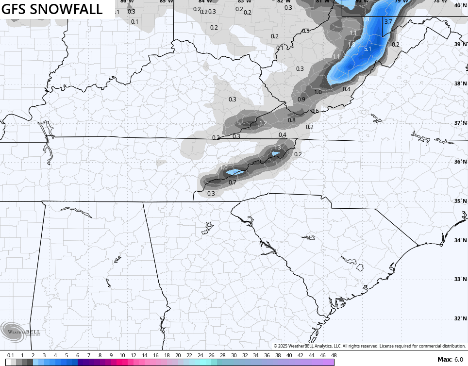
Again, we find the EURO at one extreme and the GFS at the other extreme. The truth is usually between the two and I suspect we see them both meeting in the middle in the coming days.
Regardless, the chance is there for some light accumulations for some Sunday night and Monday.
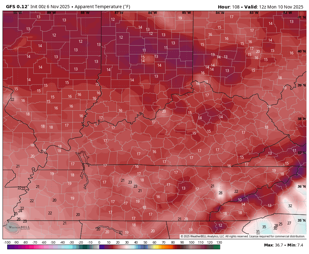
One thing the GFS and EURO both agree on is the arctic cold air coming in. Wind chills hit the teens Sunday night then again Monday night. Here’s the GFS from 7am Monday to 7am Tuesday…
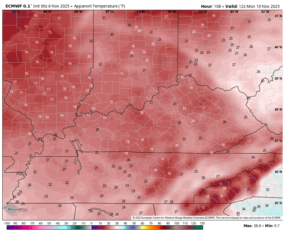
The EURO is very similar during this same time period…
Once this shot of winter pulls out of town, we go into a setup that will feature more back and forth in terms of temperatures into the middle of the month. Don’t be surprised if we see another deep trough similar to this one show up at some point. The models are hinting at this potential, similar to how they hinted at this one from nearly two weeks out. Just look at the progression of this upcoming system on the models. They went from seeing nothing to a little something and now to a full blown arctic air mass with the chance for snow.
Models are guidance and that’s it. It’s up to us to figure out what they’re trying to say in the medium range.
While on the subject of deciphering what forecast models are trying to say, the EURO Weeklies continue to say winter starts early for much of the country, including right here in Kentucky. Here’s the average snowfall forecast from the 101 members that comprise the EURO Weeklies…
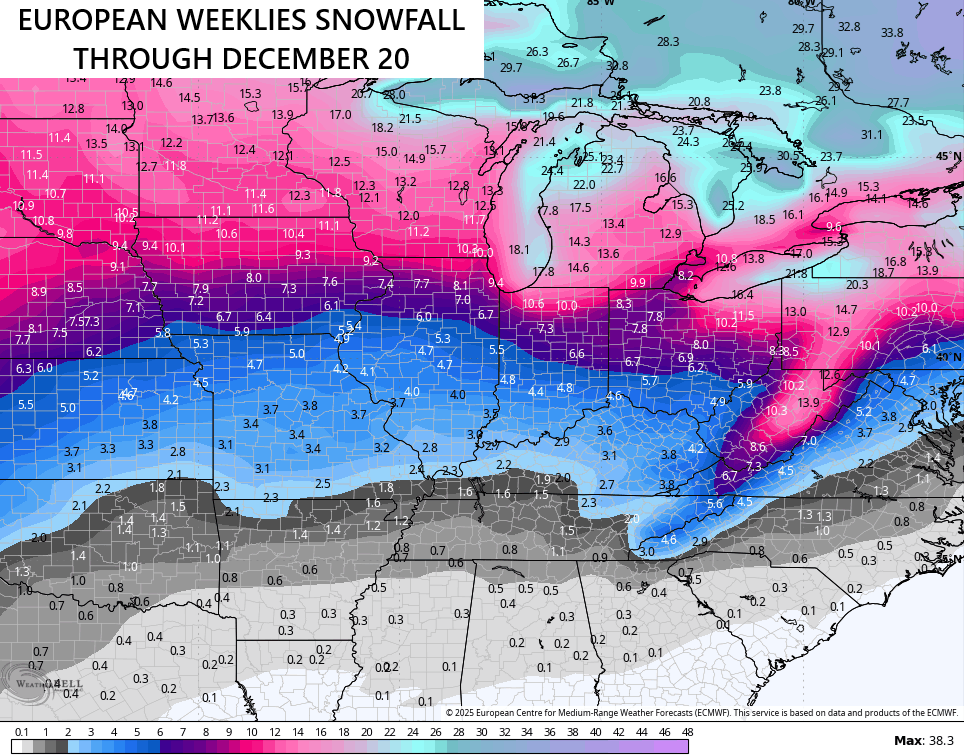
I’m glad the model is trying to say the same thing I’ve been saying here on KWC since back in the summer. ha
I will have another update later today and I’ll send out some updates on my Meteorologist Chris Bailey Facebook Page
Make it a great day and take care.

I don’t see the EURO weeklies playing out.
So how do you see it playing out exactly?
Certainly not as much as predicted by the model…..3 inches in this area?
One of the most pronounced Snowstorm that I ever seen was the one that occurred in Terre Haute, Indiana in late November 1964. We were stranded by the storm, and had to spend the night. The next morning, there was 8 inches of Snow on the ground, and a temperature of – 5 degrees. This storm was a clipper system during a La Nina Winter.
I’ve seen a lot of Snowstorms in my days, and the one that really stands out occurred in 2004 at Christmas time in Vanderburgh County, Indiana. What a beautiful White Christmas that was, with 2 feet of Snow on the ground.
Schroeder that sounds like my kind of Christmas.
The cold I guess might be a shock to the system that’s coming but it would be nice to see some flurries fly in a couple days.
Thanks Chris. Yesterday was a beautiful Autumn day, and the foliage color is still outstanding despite the gusty southwest winds. I’m concerned again about wildfires in my area of the woods, because we still are not receiving timely rains. The past fronts ( La Nina cold fronts ) are coming through moisture starved. Hopefully, my area will have a decent shower with the next front, but it too like the previous is moisture starved. First hard freeze of the Autumn, if it occurs, will be early next week. Then it’s back to normal / to above normal temperatures at the middle and late next week.
Hoping that Northeastern and Southeastern Kentucky receive their first Snowfall of the season. If there is enough moisture supply from Lake Michigan, it could happen. Mt. Mitchell in North Carolina has already had their first accumulating Snow of the season. Higher elevation is the key to Snow this time of the year.
Looks like we’re going to get some accumulating snow also here in the Chicago Metro area in the Sunday/Monday time frame. How much we’re going to get is still in question, just like it is for you guys in Kentucky. I certainly don’t expect a major snowfall out of this, since it’s still so early in the snow season, maybe an inch or so at the most.
The cold coming in will be quite a shock to the system though, considering how much above normal we were in September and October.
Mike, Chicago can really pile up the Snow, if you have a Northeasterly fetch off the Lake. I’ve seen some really heavy Snows occur when that happens.