Good Monday to one and all. Snow showers and flurries developed right on cue Sunday evening with the main action blowing through today. An upper level low will bring light to moderate snows to central and eastern Kentucky today. This joins arctic cold wind chills to give us middle of January vibes.
A Winter Weather Advisory is out for most of central and eastern Kentucky…
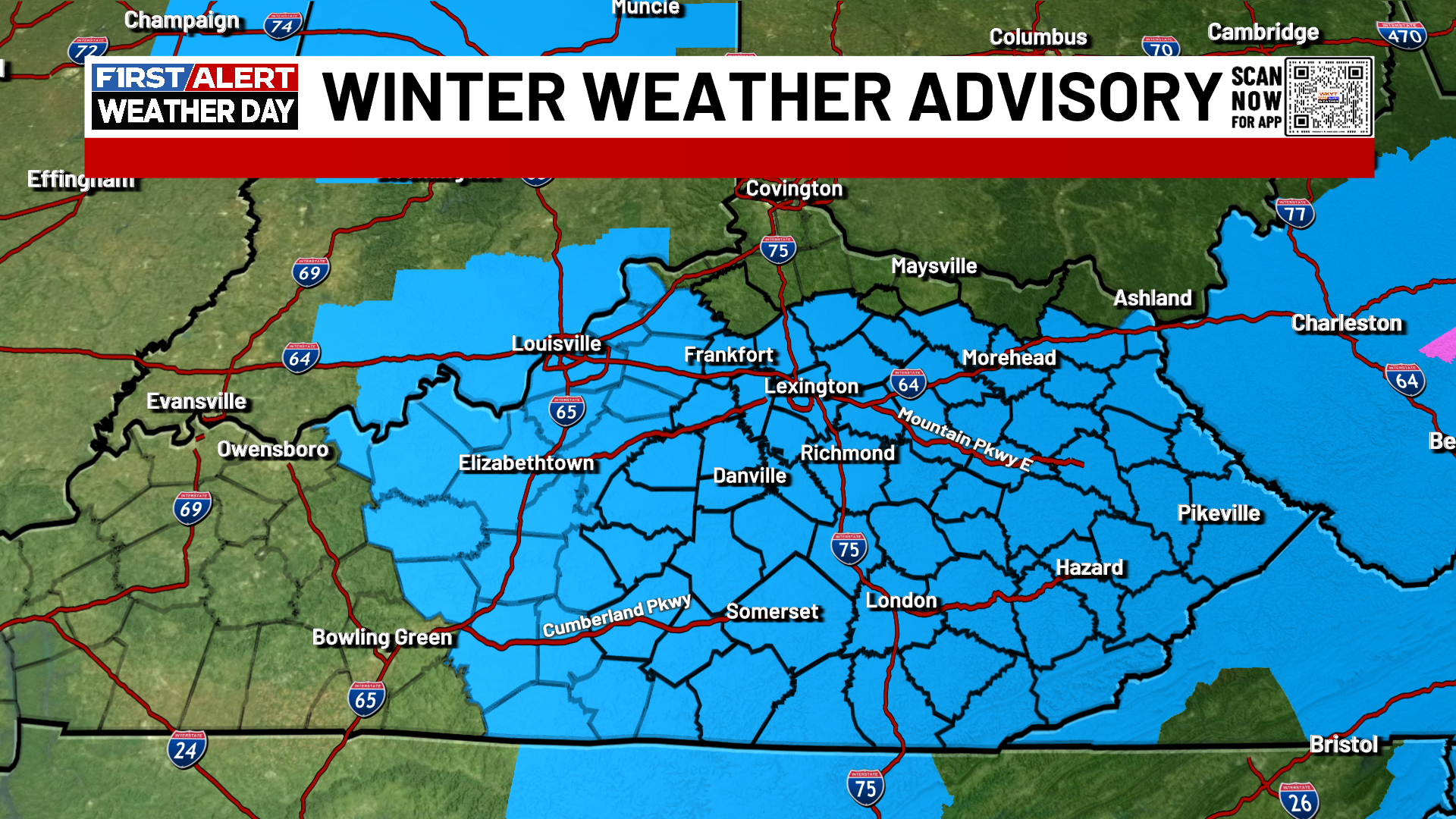
That matches up well with the areas I’ve been highlighting with the best snowfall odds…
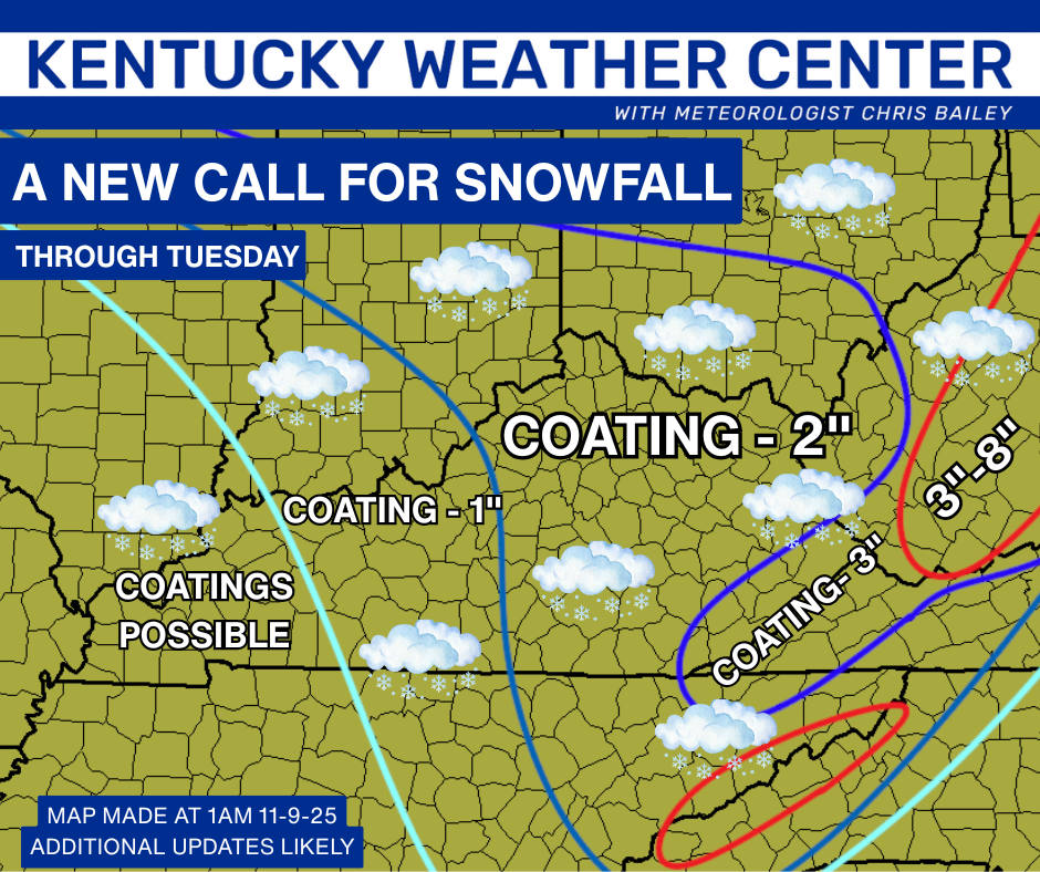
Spiraling bands of light to moderate snows will be spinning around the system dropping in from the northwest. This will come down pretty heavy at times across central and eastern Kentucky. Areas under the comma head of snow can pick up an inch or two as it spins through. This will move away this evening with snow flurries lingering before another band of snows graze the north and northeast overnight.
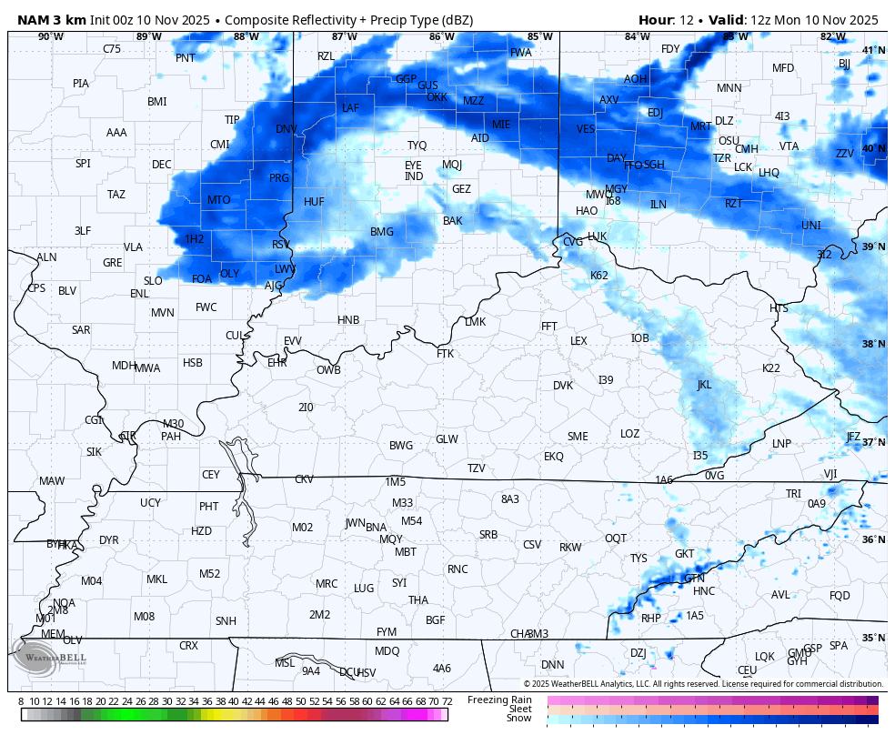
This shows up well on the future radar from the Hi Res NAM…
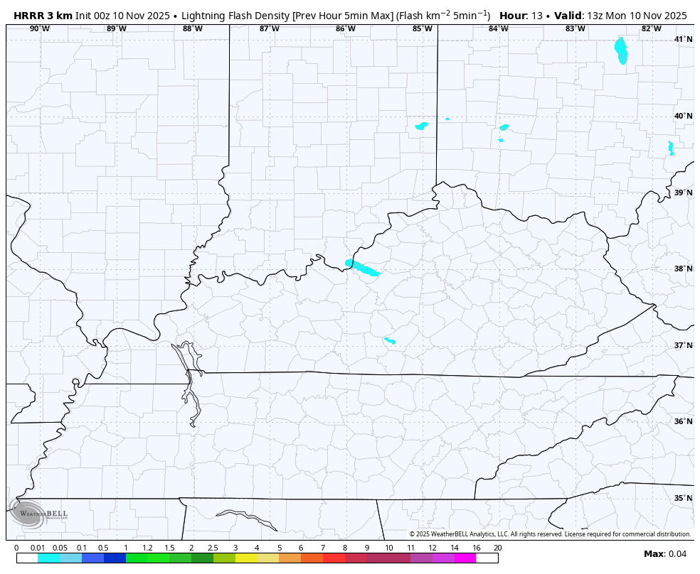
Those will be some pretty intense snow showers with some out and out snow squalls possible. The HRRR continues to indicate the outside chance for a clap of thunder today…
Temps today will struggle to get above the freezing mark for much of the day and this may lead to slick spots developing on area roads, especially bridges and overpasses. You can track the temps here…

This cold blast continues to surge into the deep south. Here’s a look at the current temps…
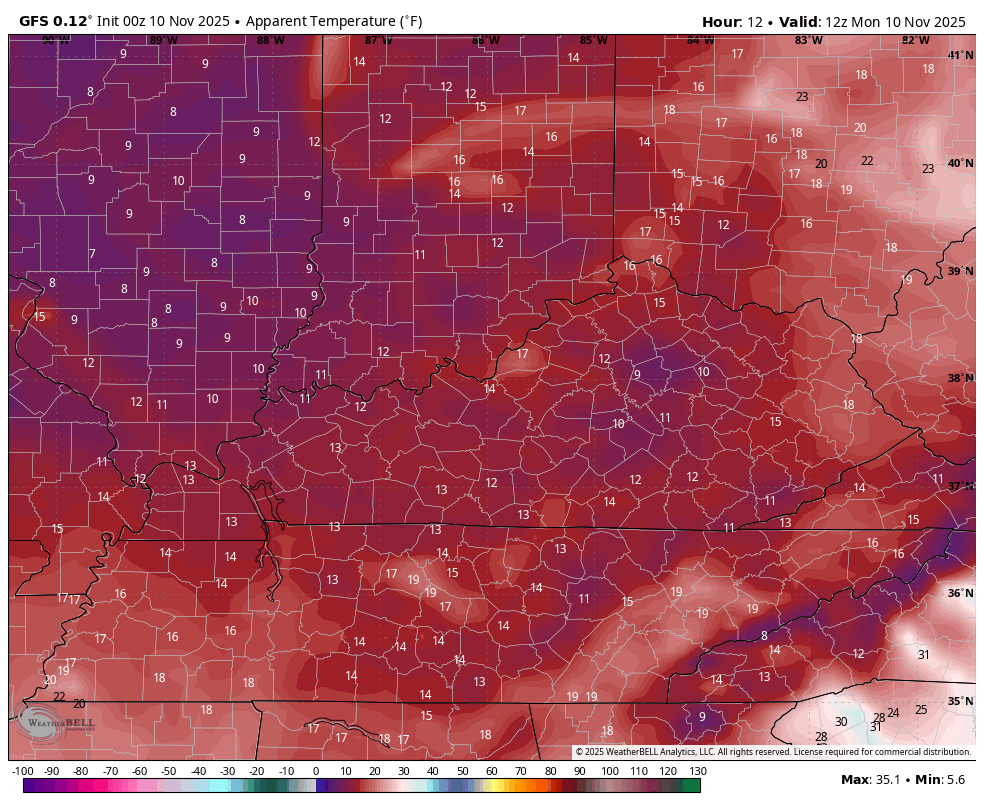
Wind chills today stay in the upper teens and low 20s during the heart of the afternoon. If misery loves company, we have a lot of company with wind chill woes…
Here’s a look at the wind chill forecast through today and into the start of Tuesday. This is ugly for the 10th day of November…
As this system pulls out Tuesday night and Wednesday, winds are absolutely going to crank as they flip around to the west. Gusts of 30mph to 40mph will be possible during that time.
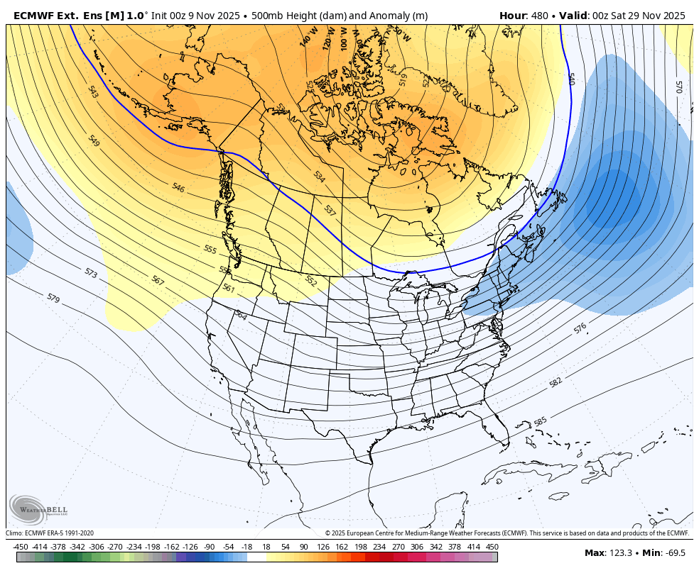
The rest of the week looks good, but significant blocking is starting in the high latitudes, and this will force several big systems to roll from west to east starting this weekend into next week. Strong storms and snowflakes are possible with these systems. This is a very energetic look…
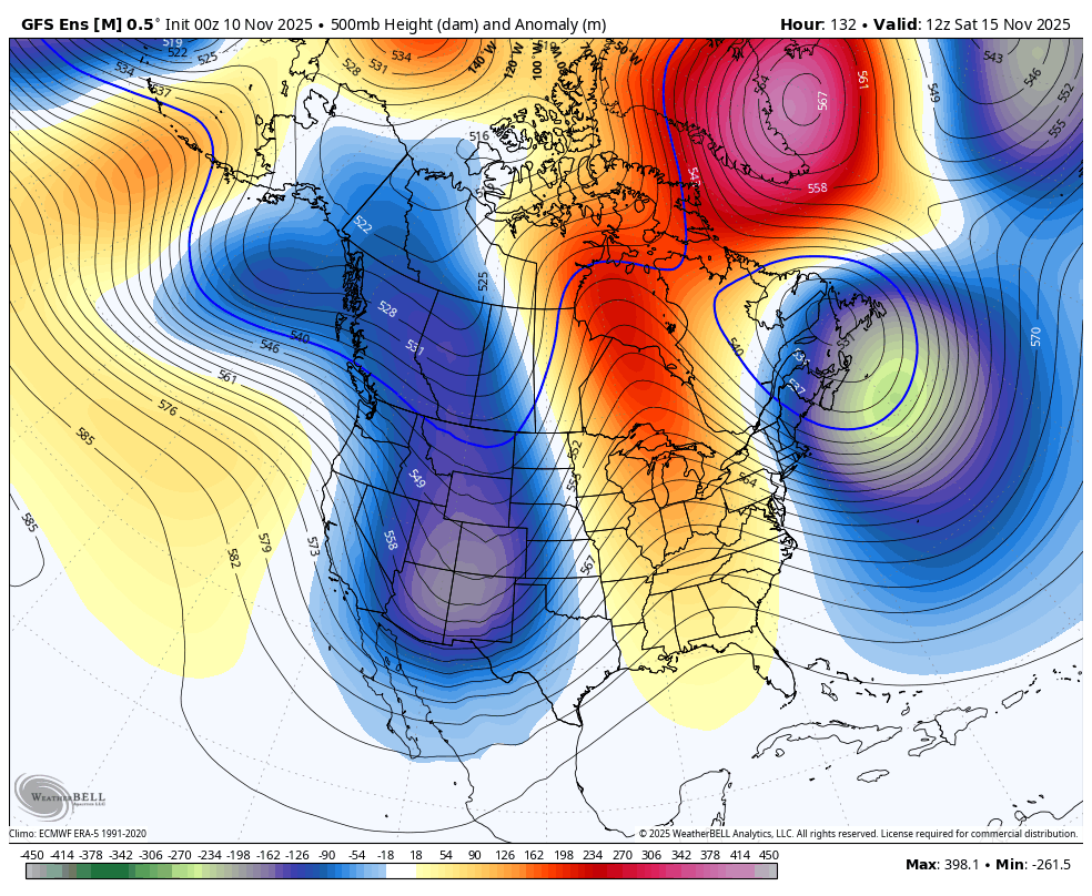
All that blocking setting up is the catalyst to lead us into a fast starting winter.
The EURO Weeklies continue to be all in on winter getting off and running on a quick note. This is a very cold looking setup for much of the country from late November through the end of this run on Christmas Eve…
This setup could very well bring snow chances all the way into the deep south…
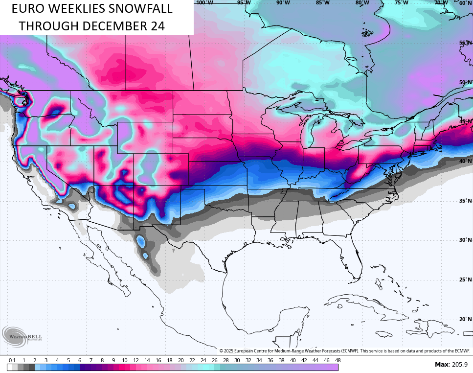
Remember, that’s the average of 101 different members. December could be a pretty harsh winter weather month for much of the country.
I’ll also have frequent updates on my Meteorologist Chris Bailey Facebook Page
Until then, here are your tracking tools for the day…


Have a magnificent Monday and take care.

We shall see.
I guess they decided to put a WWA out. Here’s hoping that we do not have a cold/snowy Dec only for winter to end Jan 1…. Didn’t that happen in 1989? I wasn’t here, but I hear that was a brutally cold snowy month. Can you imagine, in 1989, all that cold/snow BEFORE January everyone must have been thinking how AWFUL that winter was going to be… only for winter to end in January and stayed warm the rest of the winter. That’s the only thing I don’t like about cold December’s is it gives me the vibe that things will end up reversing the rest of the winter. I’d rather real winter start and go through Jan-Feb… BUT, you never really know. Dec, and Jan and FEB could be cold and snowy.. That’s also happened before.
I believe that the warming of the atmosphere will continue to impact the accuracy of forecast models beyond a couple of weeks, and this is especially evident when you compare the NWS one month and 3 month outlooks with actual values during the forecast period. The additional
One thing I believe is that we’ll see an above normal incidence of severe weather during the late winter/early spring transition. The weak La Nina we are currently in will very likely phase into ENSO-Neutral during the period, and historic records have indicated that when Nina to Neutral occurs during the transition to spring, we usually see above normal severe weather, with severe storms breaking out a few weeks earlier than normal.
Joe, here’s the NWS outlook for November : )
https://www.cpc.ncep.noaa.gov/products/predictions/long_range/lead14/
And the three month : )
https://www.cpc.ncep.noaa.gov/products/predictions/long_range/seasonal.php?lead=1
Comparing the two, there seems to be a lot of discrepancies in their long range models compaired to the one month model forecast. I agree, it’s the Earth’s warming atmosphere. ENSO / El Nino is forecast to phase into the picture sometime in May 2026, but will the PDO become positive ? Is the big question. A few years back, we had an El Nino Winter, but was cancelled out with a negative PDO.
Mid- Winter into Spring will be stormy, and I live in the center of ” Dixie Alley ” an Eastward extension of ” “Tornado Alley ” due to the warming going on in our atmosphere.
I like winter to be done after Christmas. Snow is overrated. 🙂
jeff hamlin, im the same way. after christmas is over…. im ready to move on. looking forward to more daylight, warmth & springtime for sure. ive always been a spring & summer guy, but the older i get the more i dislike winter.
Being in the Landscape / Nursery bussiness for over 40 years, I always looked forward to Spring and Summer’s growing and plant selling season, but I still like Snows during the Winter months, but not the cold / dry Snow flurries we have today. What a miserable weather day it is.
Here’s the link to Gary, Indiana NWS : Heavy Lake effect Snow right now : )
https://forecast.weather.gov/MapClick.php?CityName=Gary&state=IN&site=LOT&textField1=41.5958&textField2=-87.3441&e=1
The Chicago area received a fraction of the crazy amounts that were predicted yesterday. As of 7 AM CST this morning, O’Hare Airport measured 1.6 inches of snow, while Midway Airport measured 2.5 inches. That’s a far cry from the 12-18 inches that was predicted yesterday for Chicago. Areas in NW Indiana received around a half-foot.
Here in the SW Suburbs, about a half-inch fell, but because temperatures were below freezing. that led to very slick road conditions for a time early this morning.
Thanks Mike for your Snow totals. Here in Maple we had Snow Flurries off and on all day, but very little coated the ground. The high temperature was only 30 degrees.
f