Good Tuesday, everyone. It’s a really active weather pattern kicking off today with rounds of showers and a few strong storms. This will be followed up another big rain maker later this week into the start of the weekend. Thanksgiving Week and Weekend continue to feature the transition into winter.
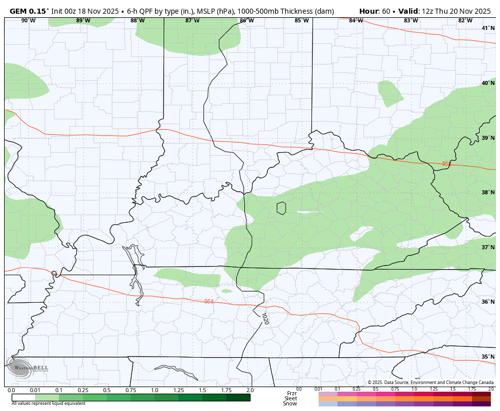
Let’s focus on today’s weather before looking farther down the road. Showers and storms are rolling in early today with the greatest concentration across the northern half of the state. Some of this may actually start with a touch of a mix in the northeast.
Temps today are nothing short of amazing with a wild swing…

This kind of a gradient can fire off some hefty storms and the low-end risk for a few severe storms is there later this afternoon and evening. This would be dropping in from the northwest to the southeast.
Today’s Severe Weather Outlook from the Storm Prediction Center looks like this…

The Tornado Risk isn’t zero, but the chance for a brief spin up is still there…

The Damaging Wind Risk looks like this…

And the chance for pockets of Large Hail…

Leftover showers will be around in scattered fashion for Wednesday with another north-south temp gradient. The stalled boundary has another storm system ready to roll eastward along it Friday into Saturday. This means more in the way of showers and some thunder from later Thursday through Saturday…
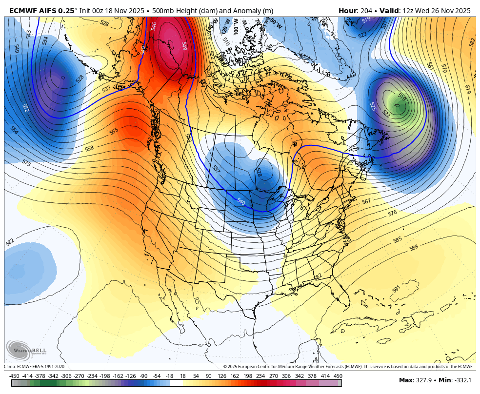
I have no changes to where this pattern goes Thanksgiving week and Weekend as we begin to transition into a full blown winter look.
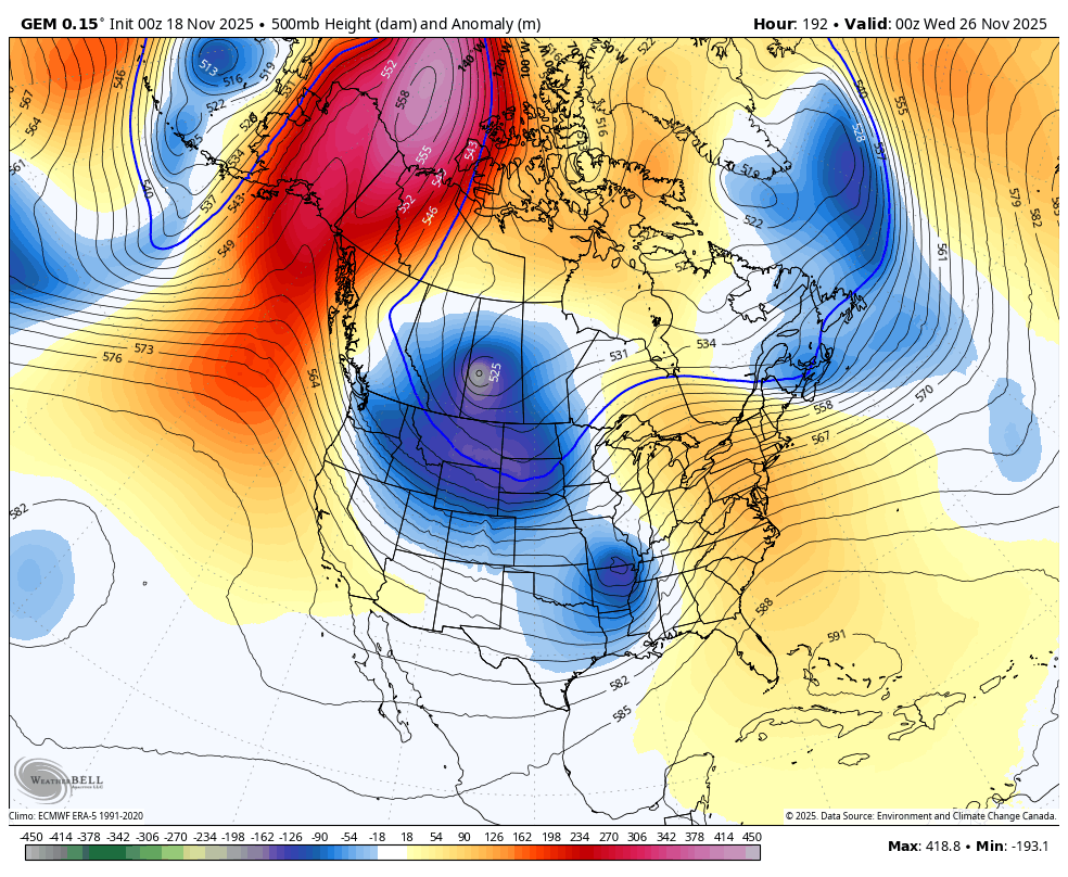
We are getting into range where the medium range models can see the beginning of everything and they’re starting to look more a like with a pre-Thanksgiving system that may bring cold in here by Thanksgiving.
The Canadian Model only goes through Thanksgiving evening, but it’s showing a deep trough sweeping in here by then…
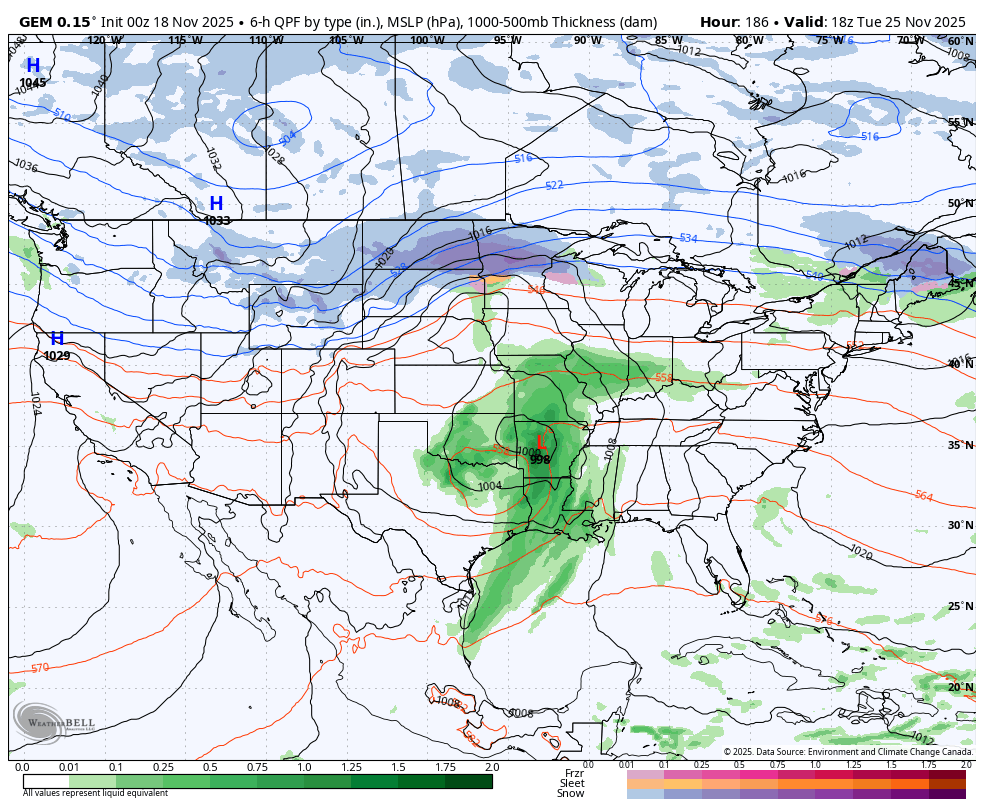
The disruptive travel storm system for Planes, Trains and Automobiles Wednesday ushers in the cold air with the Canadian continuing to show a wave of low pressure for Turkey Day. The model currently shows rain and some snow with that…
Again, we are only looking at trends here.
Check out the Barney colors surging in for Thanksgiving Day…
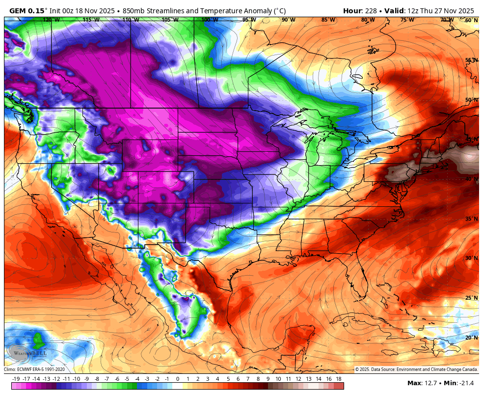
After a burp or two, the EURO AI is back in the fold and also has that faster arriving cold blast for Thanksgiving Day with a deeper trough coming in behind that to end November and hit December…
This run of the EURO AI has all kinds of Barney…
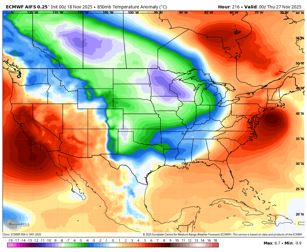
The setup on the EURO AI would also mean some potent storm systems ahead of those troughs.
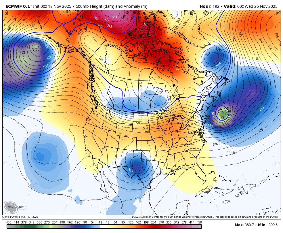
The EURO continues to go back and forth a bit with how to handle everything, but most models have been doing that so I have to cut it a little slack, but only a little.
The EURO has a similar look as the Canadian in bringing a PTA storm for Wednesday with cold and maybe a few flakes for Thanksgiving Day…
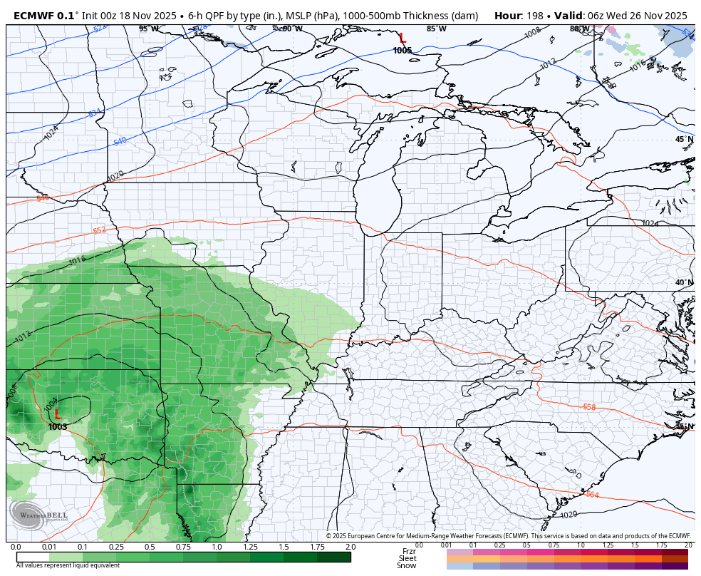
If you know the biases of the models, you can read what they’re trying to say. One of the biggest biases of the EURO is that it keeps troughs in the west instead of pushing them out into the east. The EURO is already correcting that bias with the Thanksgiving trough and you can see how it likely do the same with the follow up trough it has slowly coming from the west…
To be honest, there’s probably a little more winter potential than I’ve been thinking for Thanksgiving Weekend.
It’s interesting to watch all this unfolding at EXACTLY the time the EURO Weeklies were showing more than two weeks ago. The EURO Weeklies continue to grow much more emphatic on a deep trough encompassing much of the country, especially the east, for December…
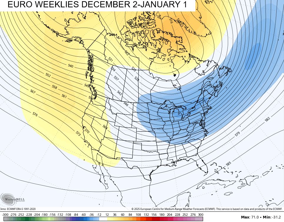
Coast to coast cold continues to show up in that same 30 day window…

Those numbers will grow SIGNIFICANTLY colder as we get closer.
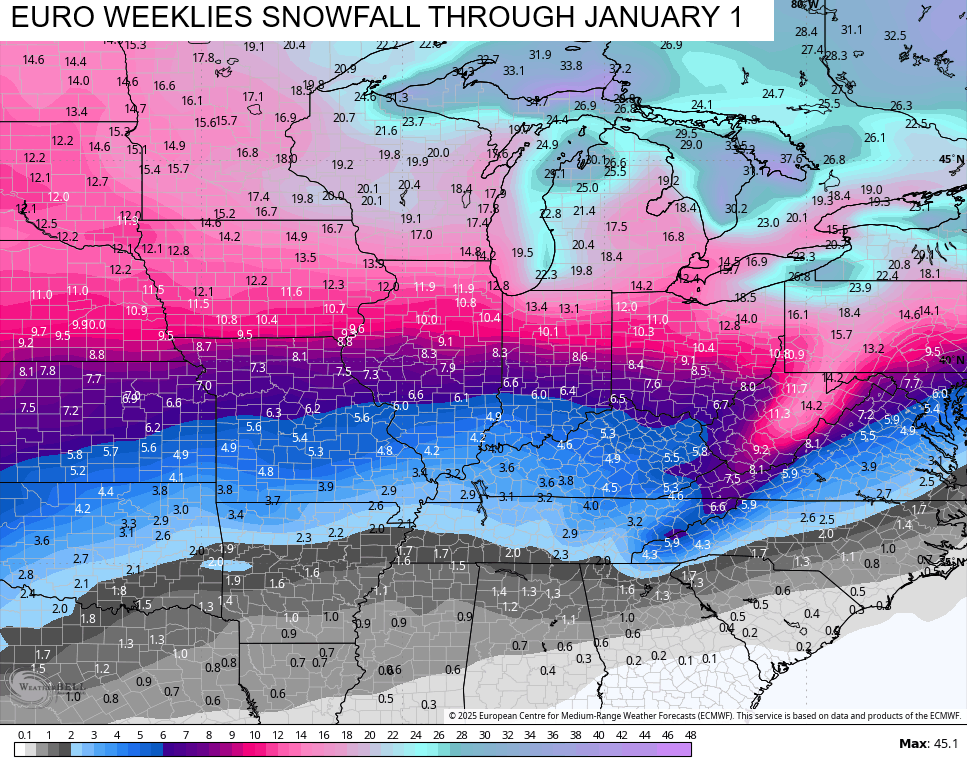
The EURO Weeklies continue to show lots of snow opportunities through the end of the year…
My Winter Forecast comes out Thursday at 6pm on WKYT-TV. We will also have a full half hour winter weather special Thursday at 6:30pm on the CW Lexington and streaming on WKYT+. This also begins a one of its kind show for this entire region… The First Alert Weather show will be each weekday at 6:30pm on the CW Lexington and streaming on WKYT+. Yep.. You get a full half hour of me and my First Alert Weather team each weekday going forward. I have big plans for this thing!
I will have another update or two later today and, of course, I’ll have updates on my Meteorologist Chris Bailey Facebook Page
Until then, here are your tracking tools for the day…


Current watches

Possible Watch Areas

Make it a great Tuesday and take care.

Looking forward to your new weather show Chris.
Dottie, Brother says that Deer harvest this year has not been that productive. He blames it on the abnormally warm weather. What have you found out about this year’s hunt ?
It is way down this year and I think your brother is right about the warm weather. Opening day was so foggy that we only heard 6 shots where we normally hear around 30 at daylight. Hubby got a nice buck so we have meat in the freezer but I’m still hoping to get a shot at a 10 pointer that is still making appearances on our cameras.
We been seeing some Bucks, but not like last year’s hunting season. Congratulations on your Husband’s harvest. Keep watch for that 10 pointer. That’s a real trophy !
Thanks Chris. Very Interesting Blog, with that Amazing Temperature Contrast, will be Surprise if there isn’t any Severe Weather in our Area today. Looks like Winter Weather will Arrive just in time for Meteorological Winter to begin.
Congratulations on your First Alert Weather Show. I hope I can receive the Show here in Taylor County. I will certainly try to get it set up
Illinois Mike. Here’s an article that may interest you : )
https://climateimpactcompany.com/daily-feature-chicago-and-boston-winter-2025-26-snowfall-forecast-2/
You may have Lots of Snow to Shovel this Winter !
Thanks for the interesting article Mr. Schroeder!
They’re saying that the consensus is for above normal snowfall for the Chicago area, but below normal in forecast confidence.
We are overdue for a snowy winter after the anemic totals we’ve had the last two winters.
We may be in line for some real-deal cold throughout December. Stratospheric warming will kick in the week after Thanksgiving, which in turn, increases the likelihood of a full blown polar vortex intrusion. This differs from last winter’s multiple “stretched” PV’s. Despite what could be record cold during the period, I’m still leaning towards this being a front-loaded winter. The signal will be the onset of severe storms in the deep south in early February, with above normal severe weather in the Tennessee and Ohio river regions in early spring.
Also Joe, Mid to Late Winter may be interesting, as we phase from ENSO / La Nina to Neutral. Could have some Major Snowstorms, as well as Early Spring Severe Weather. We shall see.
Joe, here’s an article from the Climate Impact Company on Stratospheric Warming to occur sometime soon : )
https://climateimpactcompany.com/u-s-daily-report-winter-hdd-forecast-tracking-the-stratosphere-2/
Joe try this link, the one I gave you can no longer be found : )
https://climateimpactcompany.com/u-s-midday-report-12z-gfs-shifts-the-stratospheric-warming-to-northern-canada-causes-colder-11-15-day-change-monitoring-other-stratosphere-forecasts-to-validate-is-important-2/
This morning on the weather channel they show that the Climate weather center was showing above normal temps was predicted l from now to Dec 1st here in eastern part of US. That’s a far cry in what Chris Bailey is forecasting.
That time period may average out above normal.
I put very little faith in the Climate Prediction Center 7 to 10 day forecasts, especially their long term 1 month and beyond, models. These models for the most part are tied to the GFS forecasting system, which we have witnessed is generally useless until 48 to 72 hours out. The algorithms for the GFS reflect conditions that existed several years ago, when the warming of our atmosphere had not progressed to the state that exists today. The model’s algorithms require adjustment, which means that the weather service must appropriate funds in order to do so. Obtaining those funds in the current climate that exists in DC is NOT a given!