Good Wednesday to one and all. On this busiest travel day of the entire year comes our annual tribute to one of the all-time great movies. Planes, Trains and Automobiles features Steve Martin and the late John Candy. In honor of this classic, I’ve been using that title for this very same post each year since 2005. Yep… That means you guys have been reading Planes, Trains and Automobiles for 20 years now. Wow!
The first few years of that were on the original WKYT blog I started. A few years later, Kentucky Weather Center was born and that’s where the PT and A post lives on.
This wonderful movie is set around Thanksgiving with Steve Martin’s character trying to get home to Chicago, but a snowstorm derails all that. Throw in John Candy’s amazing character and you have all the makings of all kinds of awesomeness.
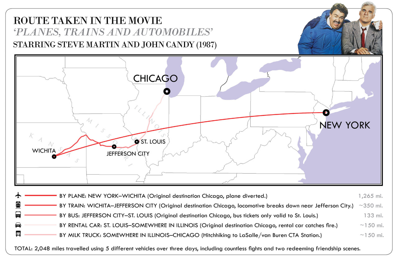
Here’s a quick look at their journey…
I’ll have more on this movie a little later on.
Let’s also talk about the weather because cold air is crashing in out there today, setting the stage for a winter flex to end November and begin December. Our cold front is racing across eastern Kentucky early this morning and has a few showers along and ahead of it. Winds are whipping around as our temps drop through the 40s and into the upper 30s from northwest to southeast today.
Those gusty winds will make it pretty darn frigid out there. Here are the wind chill numbers from 7 this morning through 10 this evening…
The chance is there for a few late afternoon or evening flurries, especially in the north and east. Here’s the future radar from the HRRR showing a couple of blue returns…
Your Thanksgiving Day is cold with temps in the upper 20s and low 30s with a wind chill in the upper teens and low 20s to start, with upper 30s and low 40s during the afternoon with a wind chill of 25-30. A mix of sun and clouds will be noted with a stray snowflake possible.
Black Friday shoppers will encounter frigid temps with lows in the upper teens and low 20s to start. Wind chills may be as low as 10-15. Highs only reach the low and middle 30s with wind chills staying in the 20s. But, it’s mostly sunny, so you have that going for you.
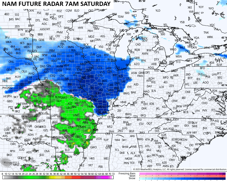
That brings us to the weekend and a storm system moving in from the west Saturday into Sunday. With antecedent cold air in place and pretty limited warm air advection ahead of this system, rain and some snow will be possible late Saturday. That may go to a period of cold rain on Sunday before ending as a bit of a mix or some wraparound snow showers later Sunday.
The NAM only goes out to 7am Saturday, but has a snowy look on the leading edge of the precipitation shield moving into the far west…
After some of the wildest models swings I’ve ever seen, and that’s saying a lot, we now find most of the medium range models coming up with the same solution for our weekend system. I still like what the GFS is doing with some light rain and light snow overspreading the region later Saturday with chilly rains Sunday, ending as a few flakes by Sunday night…
The Canadian Model is pretty spot on to that…
So is the EURO…
Go back and read through some of my posts over the past weeks to see just how poorly the models have been… It’s astounding. They really didn’t get a decent handle on this until just a few days before, so keep that in mind when looking at model forecasts going forward.
Another storm system is likely to develop right behind this one by early next week. This should track farther south and east meaning we will need to be on guard for a potentially bigger winter event around here.
Once again, the models have been all over the place with the entire setup, but they are slowly starting to pick up on the potential. The GFS has FINALLY given up on developing tropical systems and, as long as that continues, it means we can give the model a little more attention now.
I think the latest run is onto something with the system from late Monday through Wednesday..,
The Canadian went from taking that system so far to our northwest that we had to watch for severe storms to now showing it so far to our southeast that it barely grazes us with a little snow…
The EURO just does not handle systems coming from the southwest very well, but the model is seeing the potential…
Regardless of storm tracks, the end of November into the start of December is looking every bit as cold as we’ve been talking about for weeks now. This map shows just how cold the 7 day stretch that starts with Thanksgiving Day looks to be…
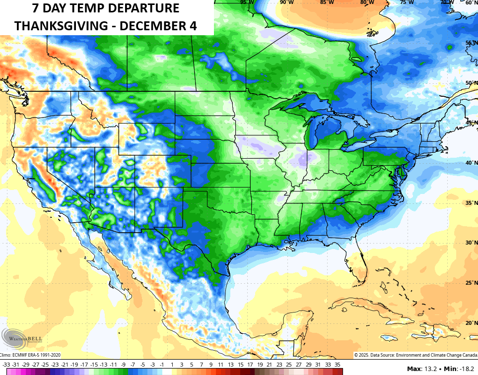
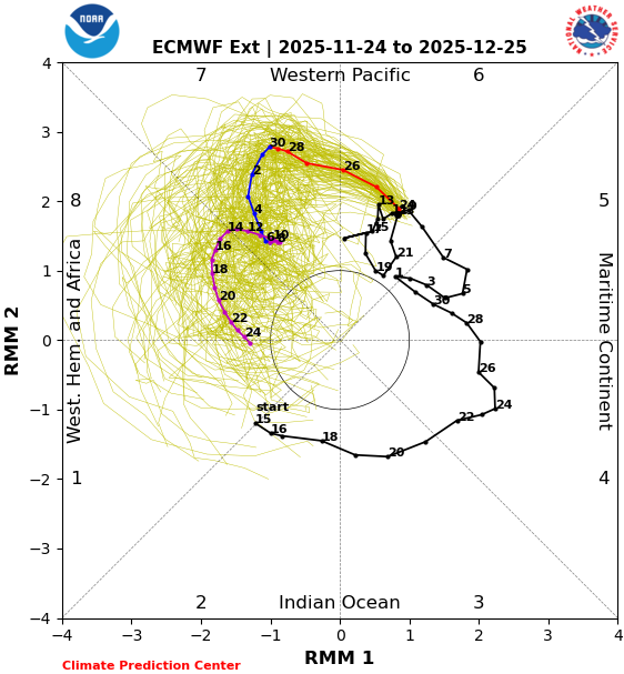
That map sure looks a lot like what we expect with Phases 7 and 8 of the MJO…
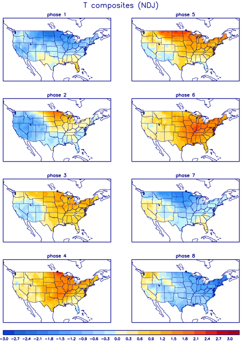
It’s interesting to note we are already seeing such cold with the MJO just now getting into Phase 7. Look at how the forecast takes this through Phase 7 over the next 2 weeks, then into Phase 8 in the leadup to Christmas…
Those Phases mean a lot more cold shots are coming to the country in December, and I’m worried about the potential for a severe arctic outbreak or two before we get to Christmas. Lots of snow opportunities will accompany this pattern. This is a harsh winter setup for much of the country.

That takes us back to Trains, Planes and Automobiles before we close. This is a must watch video with Steve Martin remembering John Candy and talking about a scene that was left out of the movie…
Steve Martin remembering John Candy from their time together on PLANES, TRAINS AND AUTOMOBILES. pic.twitter.com/bHCQUiOQkU
— All The Right Movies (@ATRightMovies) October 31, 2024
And as always, we have to throw in this absolutely classic scene…
I just noticed this is one of the longest posts I’ve ever written with my word count topping a thousand. Dang. I will have updates later today and I’ll have a few updates on my Meteorologist Chris Bailey Facebook Page
Until then, here are your tracking tools for the day…


Make it a wonderful Wednesday and take care.

Happy Thanksgiving Chris , it’s hard to believe it’s been 20 years! Since the first blog! I remember and have been with ya the entire 20 years buddy! Planes , trains and automobiles! Are the tradition for sure!! Now let’s gets some snow rollin ❄️☃️
I vote for little to no snow. 🙂
It may be that way Jeff, as this is another La Nina Winter. As the past La Nina Winters were mostly Snowless in my area of the State. Meteorologist, have always concurred that ” no two La Nina’s are alike. ” We shall see what happens, as we get deeper into the Winter months.
Thanks Chris. A very detailed, and informative blog this morning before Thanksgiving. I wish You and Your Family a Wonderful and Happy Thanksgiving, and All at WKYT in Lexington. Maybe we will see that bout of Winter weather in a week or so. Hoping that it won’t be a freezing rain event. Also, Happy Thanksgiving to all my Weather Friends.
Be Safe Everyone !
Here’s historical weather for Lexington on Thanksgiving Day : )
https://www.weather.gov/media/lmk/climate/clilex/Thanksgiving_weather.pdf
I had to drop in for our yearly tradition. Chris I hope you and All the weather blog will have a Happy Thanksgiving!!! Try to stay warm.
GFS is loaded, probably eye candy but we have winter weather to track in November. Favorable MJO forecast heading into December, could it be legendary December? Hoping
This could be a long winter, but we shall see. Happy Thanksgiving everyone
The Chicago Metro area and all of Northern IL seem to be in a sweet spot for a major snowstorm this weekend! But as always, some questions still remain this far out, so we’ll see how all this evolves.
It’s a windy, cold day here, 34 degrees with west winds gusting around 45 MPH and even higher.
Mike, here’s the link to an article from the Climate Impact Company you may be interested reading : )
https://climateimpactcompany.com/u-s-medium-range-forecast-cold-pattern-arrives-cold-retreat-in-extended-range-less-aggressive-2-2/
Here in South Central Kentucky, I have never seen much Snow in La Nina Winters, and we had plenty of them in the past 18 years. Last Snowy Winter here was in 2014 – 15, an El Nino Winter. At one time we had 15 inches of Snow on the ground.
I’m going to watch and track any Lake effect Snows in Michigan. Could be record breaker amounts.
Thanks Mr. Schroeder! This outlook is in line with CB’s prediction of a very cold and snowy December for a good part of the country.
Cold is fine, snow is fine, cold/freezing rain IS NOT !!!
Happy Thanksgiving all !!!
Happy Thanksgiving, KWC!!
Think SNOW!