Good Thursday and Happy Thanksgiving, everyone. It’s a frigid holiday across Kentucky and surrounding areas as we get ready for some winter weather. The first threat rolls in over the weekend with the potential for a much bigger system to impact our weather early next week.
Your Thanksgiving starts with wind chills in the upper teens and low 20s and ends with wind chills in the mid and upper 20s. Clouds will be noted for the first half of the day with the chance for a stray flurry. Otherwise, it’s a mix of sun and clouds.
Black Friday is frigid for holiday shoppers. The flow has a chance to spit out a flake in the far east.
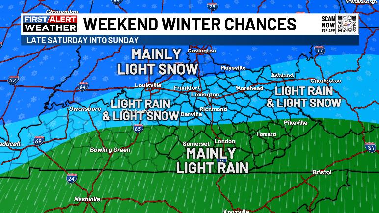
This brings us to the weekend and a system rolling in from the west. Cold, dry air is firmly in place ahead of this system that isn’t very strong. It won’t be pulling up much warm air ahead of it so the initial precipitation coming in Saturday afternoon and evening should start out in snow or a rain/snow mix. From there, we see the best chance for snow shifting to the north with chilly showers taking over into Sunday. All of this ends with a few flakes late Sunday and Sunday night.
I’ve come up with a preliminary map showing my current thoughts…
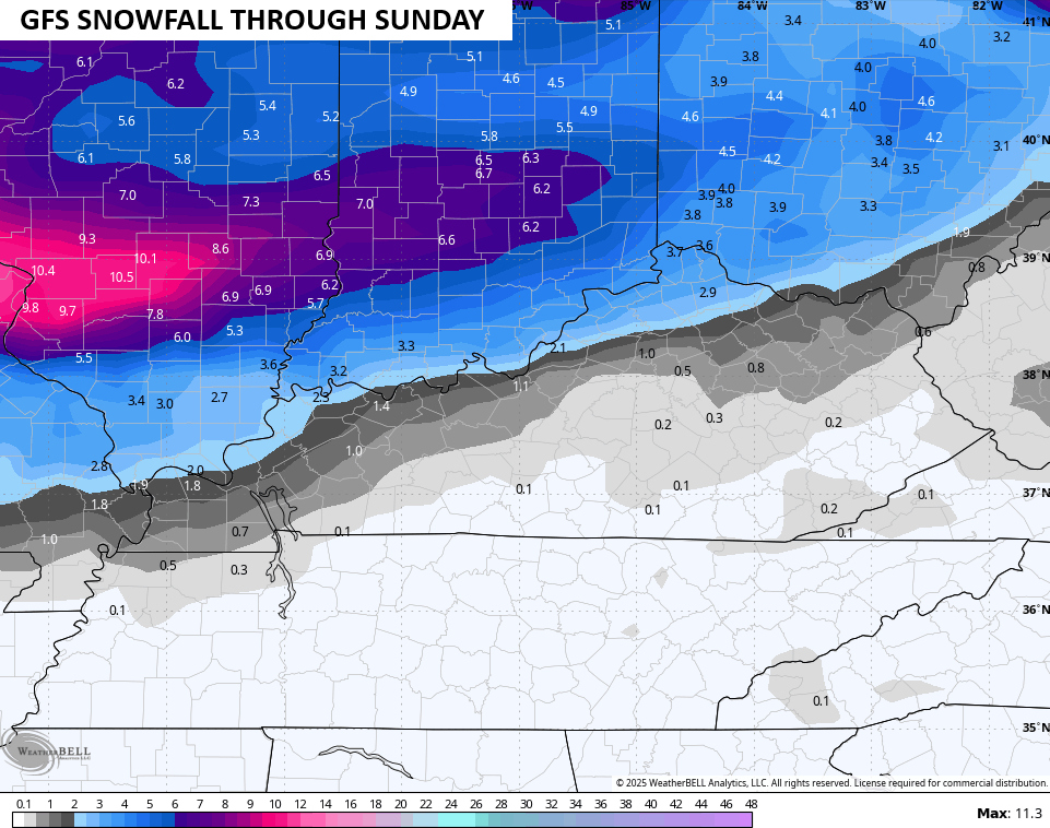
The GFS continues to be very weak with this system and has the best snow look with it…

It continues to try to put down some light accumulations from southwest to northeast along and south of the Ohio River with a smackdown north of the river…
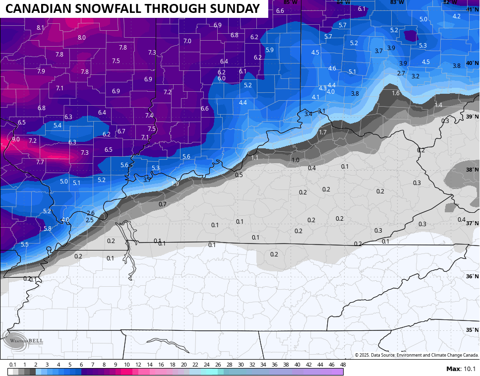
The Canadian Model and the GFS are in decent agreement on this system…
It does have a little sharper cutoff to the best chance for accumulating snows…
The EURO is the slowest and strongest with the system, likely because the model has trouble with energy coming from the southwest and how to properly handle it. The EURO has some light rain and pockets of flakes with any accumulating snows well north of our region…
While I can’t say that won’t happen, that’s not the preferred solution right now. I suspect you’ll see the model correcting closer to the GFS/Canadian look.
As that pushes through, our attention quickly turns toward a much stronger system coming in from the southwest, taking a track to our east and southeast. The details of how this plays out are a few days away from really showing up so we just look for the signal of a storm system.
As I said earlier, all modes of winter weather are on the table with this storm. Every model changes on the details from one run to the next, so don’t get attached to any one model.
Here’s the overnight run of the GFS…

And the Canadian Model for the same time…

The EURO is also seeing this storm potential…
From there, you’re going to see the models making the same exact mistake they made for the current setup as they tried to force all this cold into the west with a ridge in the east. That failed miserably, but the same extreme setup is present and it’s just too much for most of the models to handle.
I’m already looking toward late next week into next weekend for another big arctic front dropping in from the northwest. That has a chance to team with some energy coming in from the southwest, which is what’s showing up on one particular run of the Canadian…
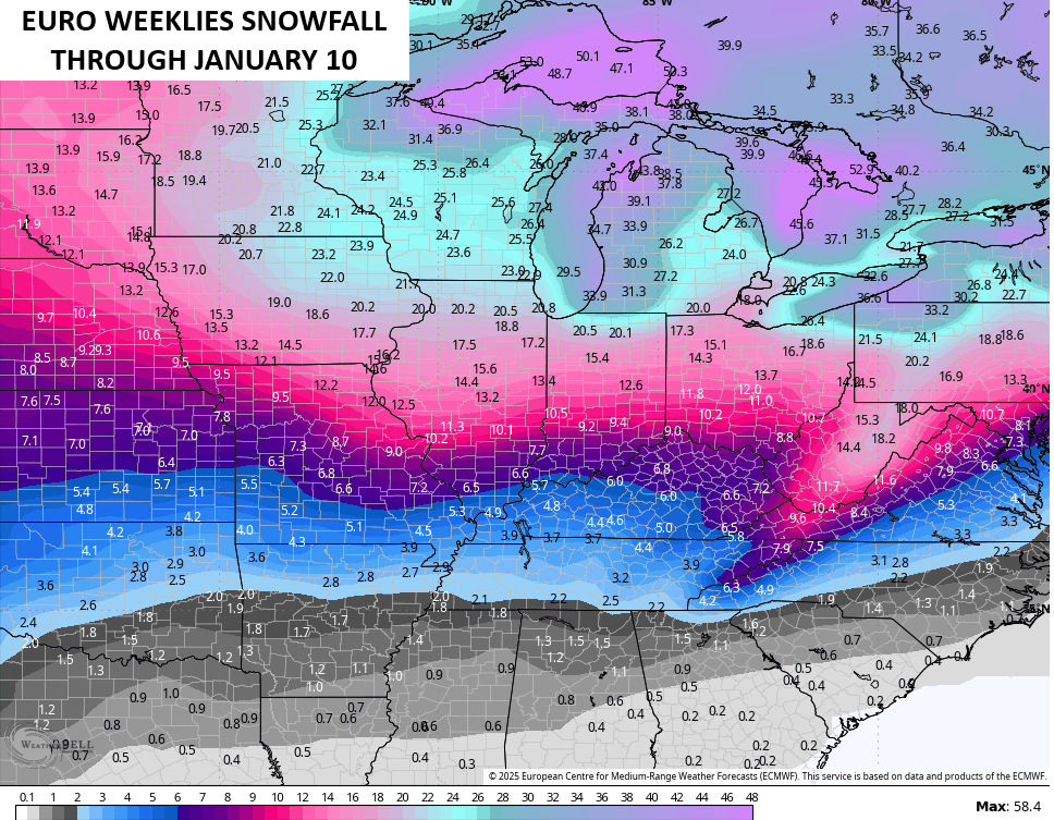
I’ve not been shy with my thoughts about a rough start to winter for much of the country and started talking about this in late summer. The pattern I envisioned is already showing up and is likely to really become established through December. The latest EURO Weeklies go all the way through January 10th and shows a cold country…
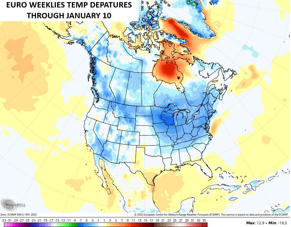
This is also the snowiest look we’ve seen from the EURO Weeklies…
I will have updates later today and I’ll have a few updates on my Meteorologist Chris Bailey Facebook Page
Have a Happy Thanksgiving and take care.

Thanks Chris, and Happy Thanksgiving. I’m thankful for the Lord has giving me another Thanksgiving. Hoping our precipitation type will be all Snow this coming Winter. Only time will tell.
Enjoy the Day Everyone, and be Safe !
Wishing everyone a happy and blessed Thanksgiving.
Gobble Gobble Gobble
Dottie, My brother harvested two Deer, this past Deer season. He said the Deer were in the woods for a little over a month eating Acorns. We have a lot of Oak trees on the property, and Pines where they can hide with the lower branches near the ground. A hard hunt this year.
ines where they can hide
Happy Thanksgiving Chris and everyone on KWC!
It looks like the start of another snow-less winter for south central Kentucky, but with the large intrusions of cold air plus the La Nina moisture flow, early winter could spell our best chance in a LONG time for snow.
Joe, what we have now here in South Central Kentucky is a very shallow layer of Arctic air at the surface. I’m more concerned with freezing rain events rather than Snow events.
Celebrating my 15th Thanksgiving with the Kentucky Weather Center.
Best wishes to all!