Good Wednesday, everyone. Old Man Winter is about to flex on us once again as I’m tracking three separate snow systems between today and Sunday. The first brings snow showers and squalls with a bigger system rolling in behind it Thursday night and Friday. The next one rolls in late Saturday.
Let’s begin with a full-blown breakdown:
TODAY
- Winds gusting to 40mph will be noted early today ahead of our arctic front.
- Gusty showers will be noted ahead of the boundary that won’t slide through until this afternoon.
- Temps start in the 40s then drop into the 30s from northwest to southeast.
TONIGHT
- Snow showers and snow squalls kick in during the evening and increase through the night.
- Some pretty good bursts of snow are possible in streaks across central and eastern Kentucky.
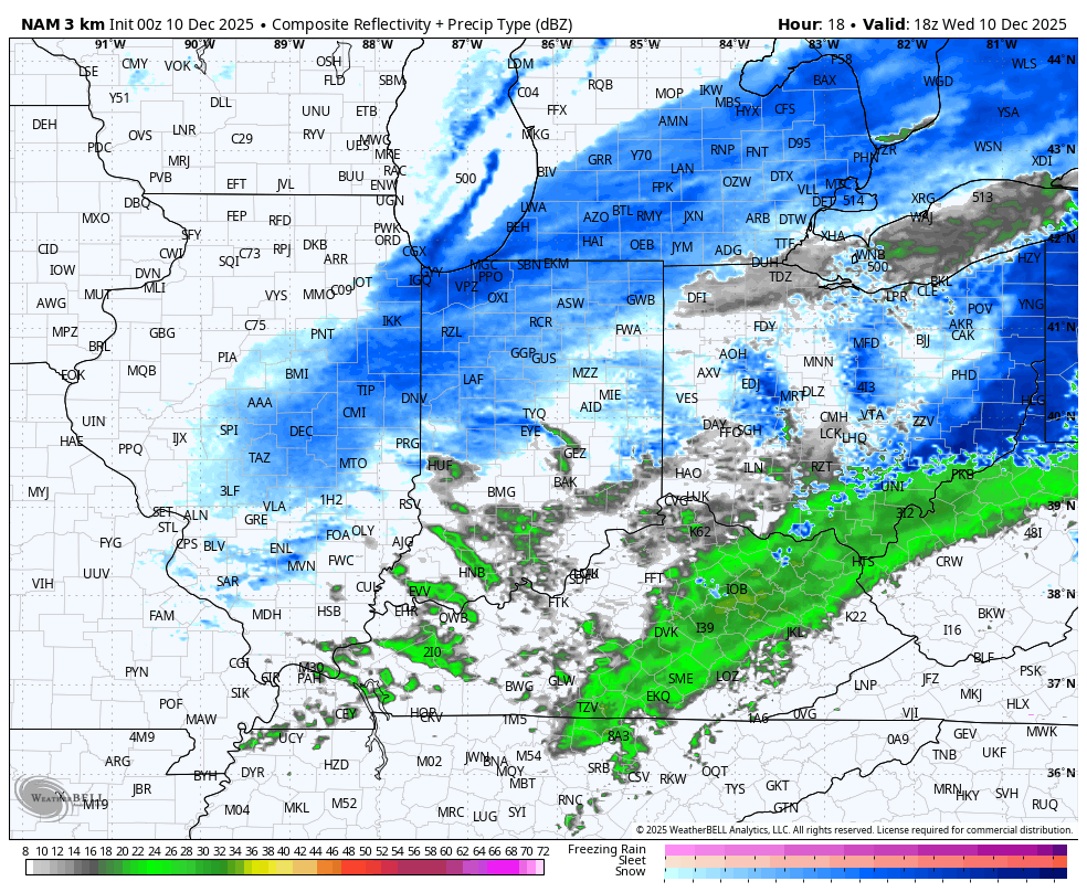
- The radar will even show a Lake Michigan snow plume reaching our region.
- This isn’t a lot of snow, but coatings up to an inch show up in some areas.
- With temps in the 20s, slick roads are likely.
THURSDAY
- Some snow days are possible.
- Snow showers and a few squalls decrease by noon.
- Snow flurries continue through the afternoon.
- Highs range from the upper 20s and low 30s.
THURSDAY NIGHT
- This may be upgraded to a Winter Storm THREAT with my next update.
- A moderate snowmaker moves in from northwest to southeast.
- The arrival time on this is late in the evening hours.
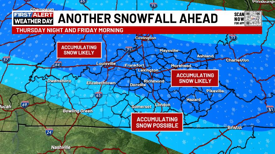
- Exactly where this sets up is still a work in progress, but I suspect much of central and eastern Kentucky see snow.
- The potential is there for this to be a “thumper” in northwest to southeast corridor.
FRIDAY
- That round of snow is with us to start the day.
- Several inches of snow may very well show up.
- Snow Days are pretty widespread.
- The snows end from northwest to southeast during afternoon.
SATURDAY
- Another snowmaker impacts the region from late day into Saturday night.
- This has the potential to be another decent snowmaker.
- There’s also the chance for this one to wind up as a WST, too.
- The exact details of this are a work in progress.
SATURDAY NIGHT
- Snow tapers to snow showers and flurries.
- Some blowing and drifting snow is possible in some areas as arctic winds crank.
- Bitterly cold air sweeps in during this time.
- Lows head toward single digits.
- Wind chills go well below zero.
SUNDAY
- This is a brutally cold day.
- Highs may not get out of the teens.
- Wind chills may stay near 0 for much of the day.
- Sunday night lows have a chance to hit 0 or below.
MONDAY
- Snow days and cold weather days are very possible.
How about that for a harsh pattern this early in the season??
In terms of the models, let’s start with today’s transition to snow showers and squalls. I mention the connection to Lake Michigan and you can see this well on the Hi Res NAM future radar. This animation starts at 1pm today and goes through 1pm Thursday…
Later today, I’m very likely to put out a Winter Storm THREAT for the Thursday night and Friday system. This wave of low pressure is fairly potent with sufficient lift along and north of the track of the low to produce a thumping snowfall. Here’s the area I’m currently thinking has the best chance at picking up on a few to several inches of snow…
This energy for this system is coming ashore in the Pacific northwest and into Canada. That’s giving the forecast models a better look at what we are dealing with, so it’s not surprising all the models jumped toward a similar looking solution. Of course, that doesn’t mean they’re exactly right, but I think they have the general theme correct.
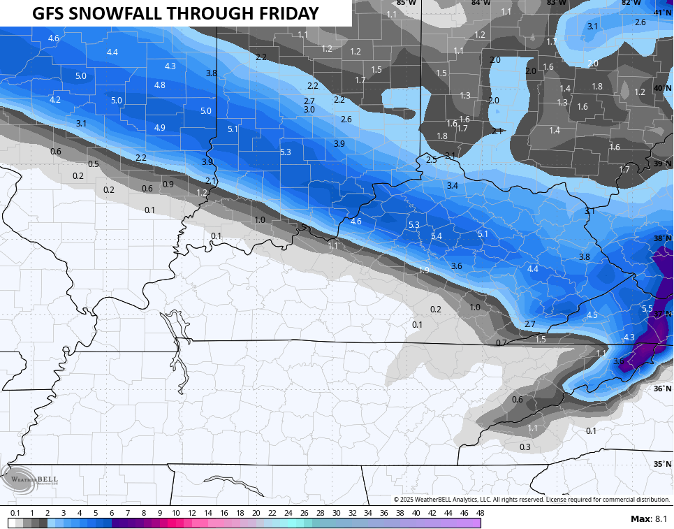
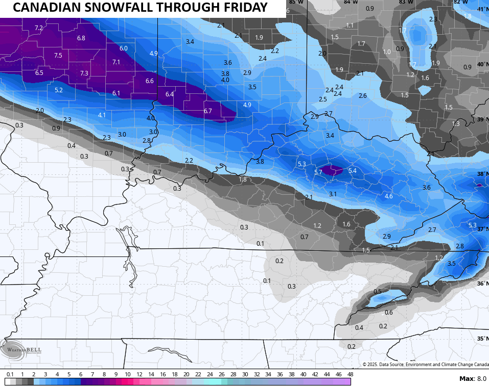
Here’s what they’re spitting out for snowfall with this system…
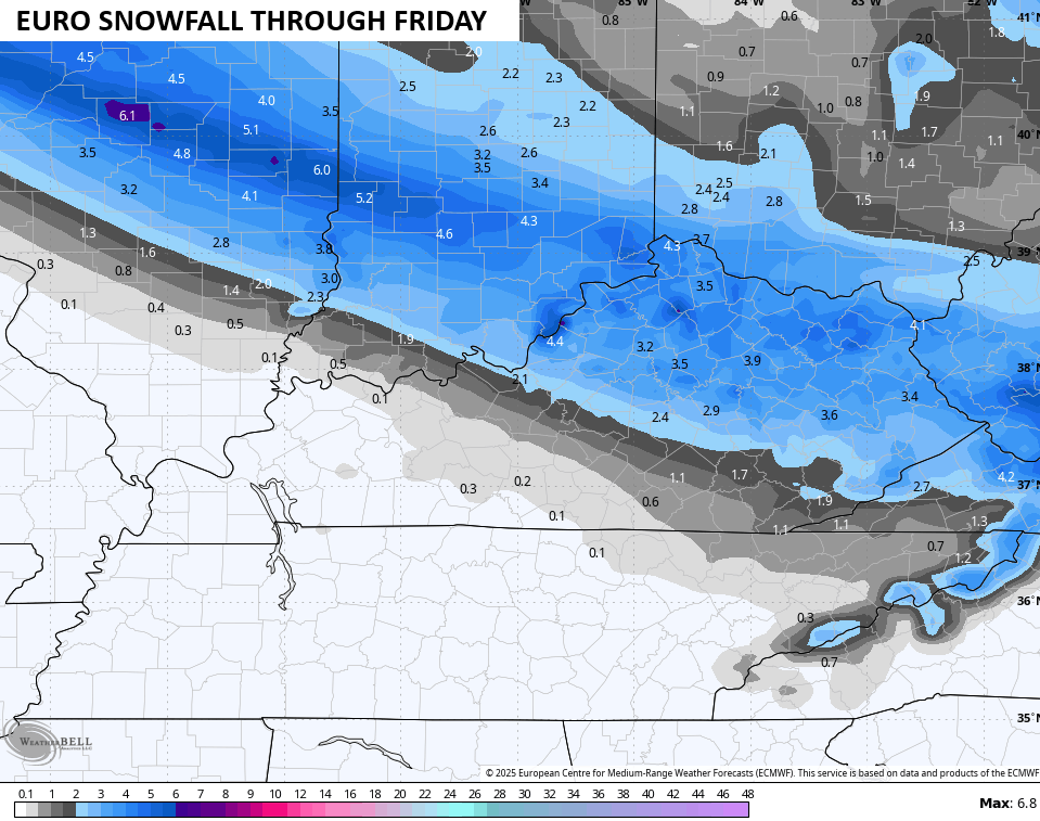
We can still get some waffling with the track of the low so some north or south changes can still show up.
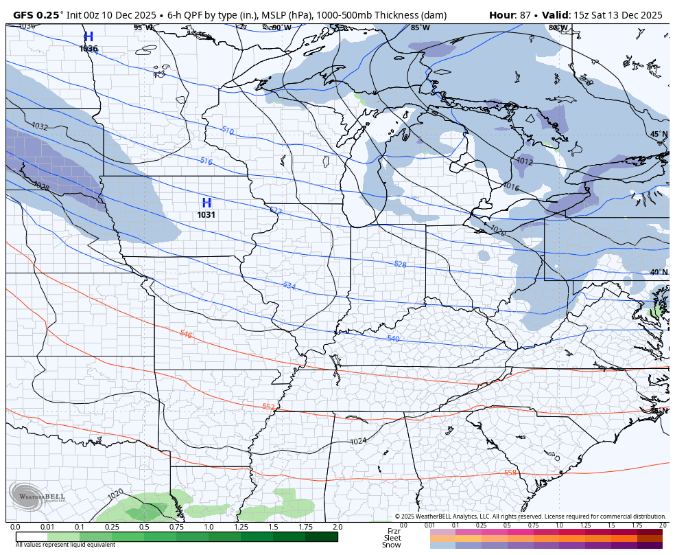
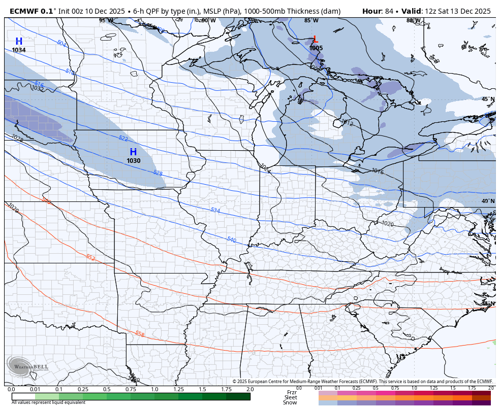
The models are now coming back around to the late Saturday system I’ve never given up on, even as all the models did. The pattern suggests we may very well wind up with a similar tracking system, but this one is riding true arctic air.
I think the models continue to bend farther south with the track because of the same reasons I’ve highlighted all week. 1. Arctic air is dense and heavy and usually pushes things a bit south. 2. There’s a tremendous snowpack across the Great Lakes and northern Ohio Valley.
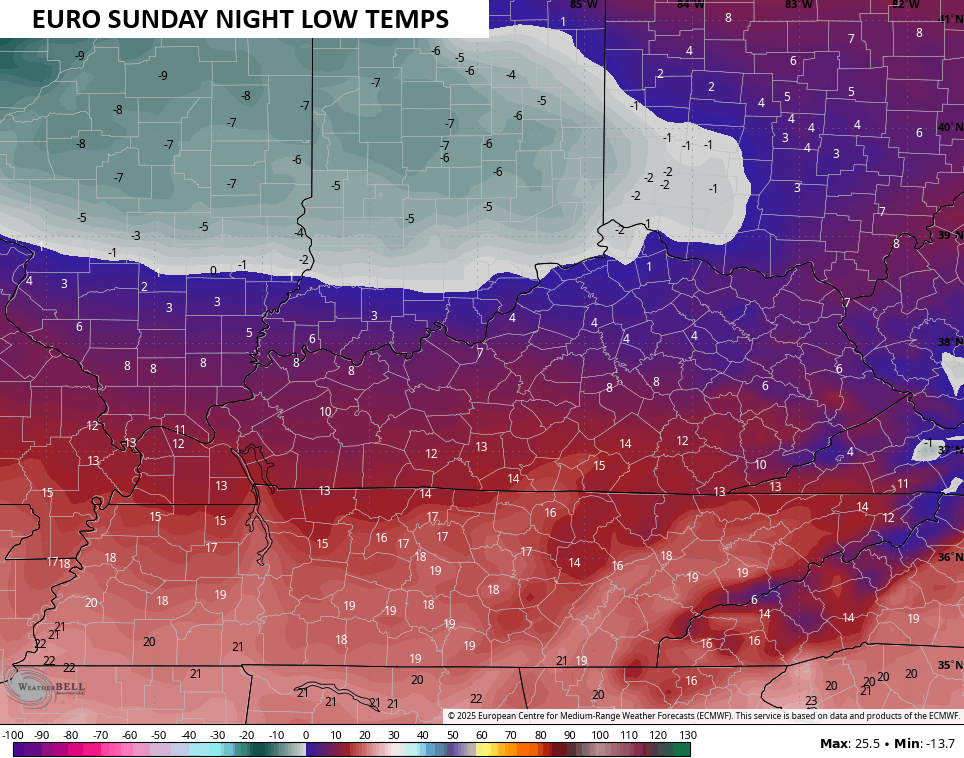
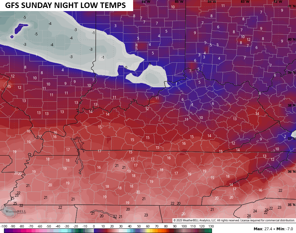
The GFS and EURO both came farther south and may still trend a bit more to the south…
GFS
EURO
Wind chills behind that system absolutely tank and have the chance to hit Cold Weather Advisory territory. The EURO certainly thinks we do that late Saturday into early Sunday. This wind chill animation starts at 1pm Saturday and goes through 10am Sunday…
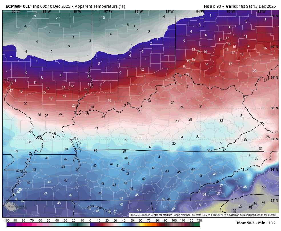
Actual lows have a chance to hit negative numbers if there is indeed a decent snowpack on the ground…
Folks, this is a lot of potential wicked winter weather taking shape over the next 5 days.
Updates come your way later today. I’ll also have a few updates on my Meteorologist Chris Bailey Facebook Page
Until then, here are your tracking tools for the day…


Make it a Wonderful Wednesday and take care.

I hope it fizzles out. 🙂
It fizzles out for WKY….no suprise.
Here in the Chicago Metro area, it’s been the quickest start to the snowfall season since the record-breaking 1978-79 season, when 24.1 inches of snow had fallen before December 7th. So far this season through Dec. 7th, 17.1 inches of snow has fallen at O’Hare Airport, which almost exceeds the 17.6 inches of snow that fell the entire 2024-25 snow season!
Here’s the link for the summary: https://weather.gov/lot/November_December_2025_Snow
We’ve had a solid snow cover since late November, but there’s been considerable melting in the last day, since temperatures reached the high 30s on Tuesday along with some light rain at night. A couple of inches still remains. But the snow cover will be increasing over the next several days, even though it looks like you guys in KY will be getting more snow than here in the Chicago Metro area.
Mike, now that’s what I call a real Winter. My Snowfall since December first has been 1 / 2 inch. I kind of wonder if we will ever have a Snowfall that will exceed our average, which is a modest 13 inches LOL….
Today is an absolutely miserable day, with a cold rain plus a wind chill. Horrible weather, but the Sun was out yesterday, which was a nice change from all the gloom.
Maybe some Snow flurries off and on through the weekend. Then hopefully, we will received those milder days next week.