Good evening, everyone. My time is rather short as it’s a busy, busy time in the weather world. We have some of the harsh stuff on the way with a Winter Storm THREAT for Thursday night and Friday and the potential for another WST later Saturday.
In the short-term, we had thundersleet and thundersnow out there today as our first arctic front slammed into the region. Now we focus on snow showers and squalls overnight into early Thursday with light accumulations showing up in streaks from the northwest. This will be enough to cause some slick travel for some…
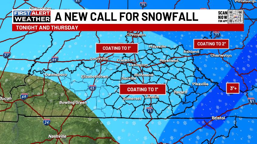
There’s a Winter Weather Advisory that continues across the southeastern part of the state with this first event…

We are now less than 24 hours away from a winter storm impacting our region and not a single NWS office in Kentucky or any of the surrounding states has bothered to put out an Advisory or a Winter Storm Watch. Think about that one for just a second. This is NOT even close to how anyone in the weather world is supposed to operate. We are in this for the people and to give them as much advance notice as humanly possible to impactful weather.
I essentially have the same snowfall forecast for this system as earlier today with a large swath of 2″-5″ of snow showing up…

The southern edge of that is the hardest part to figure out in terms of where it sets up.
This will be a high impact travel event that will lead to a lot of snow days for Friday.
The system coming in late Saturday into Saturday night is starting to look a lot like system number 2 and may very well become a Winter Storm THREAT tonight. Here’s my early look at who has the best chance for accumulations with that…

The forecast models continue to trend south with this system…
EURO
GFS
Back to back low-end winter storms on back to back days? That’s possible.
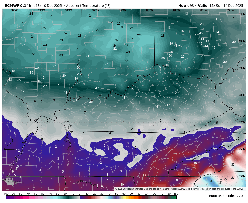
That system moves in with brutally cold air behind it. Highs Sunday may barely get into the low and middle teens for some with lows that can reach 0 or below Sunday morning then again Monday morning. Wind chills will be dangerously cold, folks.
This animation from the EURO shows wind chills from Saturday evening through Sunday morning…
Those dangerous wind chills then continue through Wednesday morning…
I may have another update or two before the full update late tonight. I’ll also have a few updates on my Meteorologist Chris Bailey Facebook Page
Until then, here are your tracking tools for the day…


Make it a Wonderful Wednesday and take care.

For those who get snow enjoy