Good Sunday, everyone. Our wild weather ride is leaving the station today, leading us into a massive change tonight and Monday. This change kicks off a pattern that looks like it can go right back into a harsh setup as we get into January.
Here’s your latest breakdown of the weather wildness:
TODAY
- A strong southwest wind kicks in as our front goes back to the north.
- Temps surge toward record highs around 70.
- If we get any sun, temps hit 70-75 degrees.
- Sunday may be one of the all-time warmest late December days on record for Kentucky.
- A couple of showers may be floating around, especially in the north and west.
Follow the temps here…

TONIGHT
- Our arctic front sweeps quickly across the state from west to east.
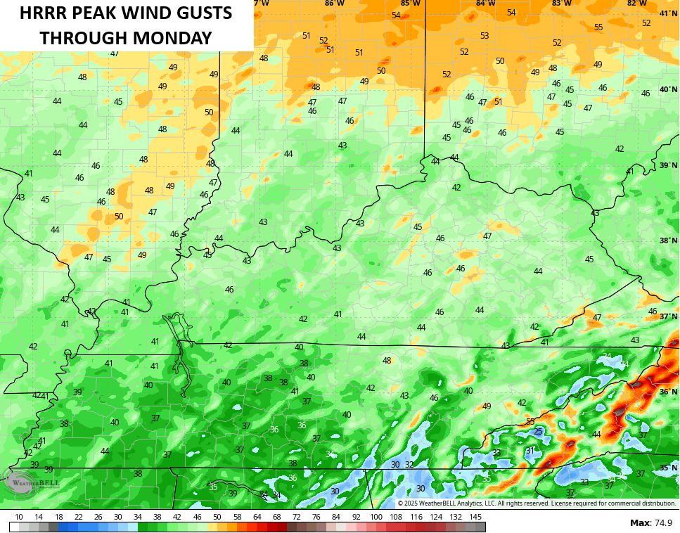
- Winds along and ahead of this front may gust from 40mph-50mph at times.
- A squall line of showers and storms will be noted along and ahead of this front.
- There’s a low end threat for a few severe storms with this line, especially across the west and central.
- Temps drop 20-30 degrees in an hour or so as this front moves through any one location.
- Readings by morning are in the 20s across the west and central with a wind chill in the teens.
- Some snow showers and flurries will be possible behind this front.
The Storm Prediction Center continues with a low-end severe risk this evening into the wee hours of Monday morning…

With or without thunderstorms, winds are going to be a big player with gusts of 40mph to 50mph at times…
MONDAY
- Temps continue to drop deeper into the 20s from west to east.
- Gusty winds give us a wind chill in the low and mid teens for much of the day.
- Single digit wind chills show up Monday evening.
- Monday afternoon and evening will feel 50 degrees or more colder than the same point on Sunday.
- A few snow showers and flurries will be possible into Monday night.
Check out those wind chills from 7am through 10pm Monday…
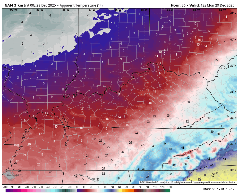
That’s going to hurt!
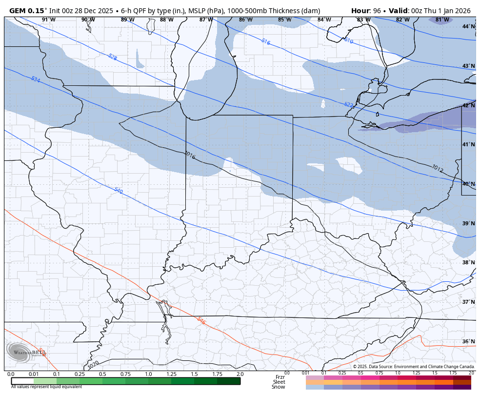
I’m not budging on the clipper light snow potential coming at us to start 2026. The models aren’t quite sure how to handle it, but they all have some version of it. Here’s the Canadian…
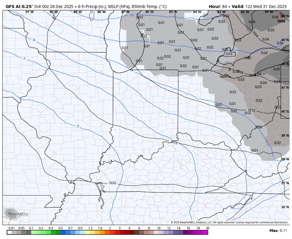
The GFS AI doesn’t show precipitation type, but it sees our clipper well…
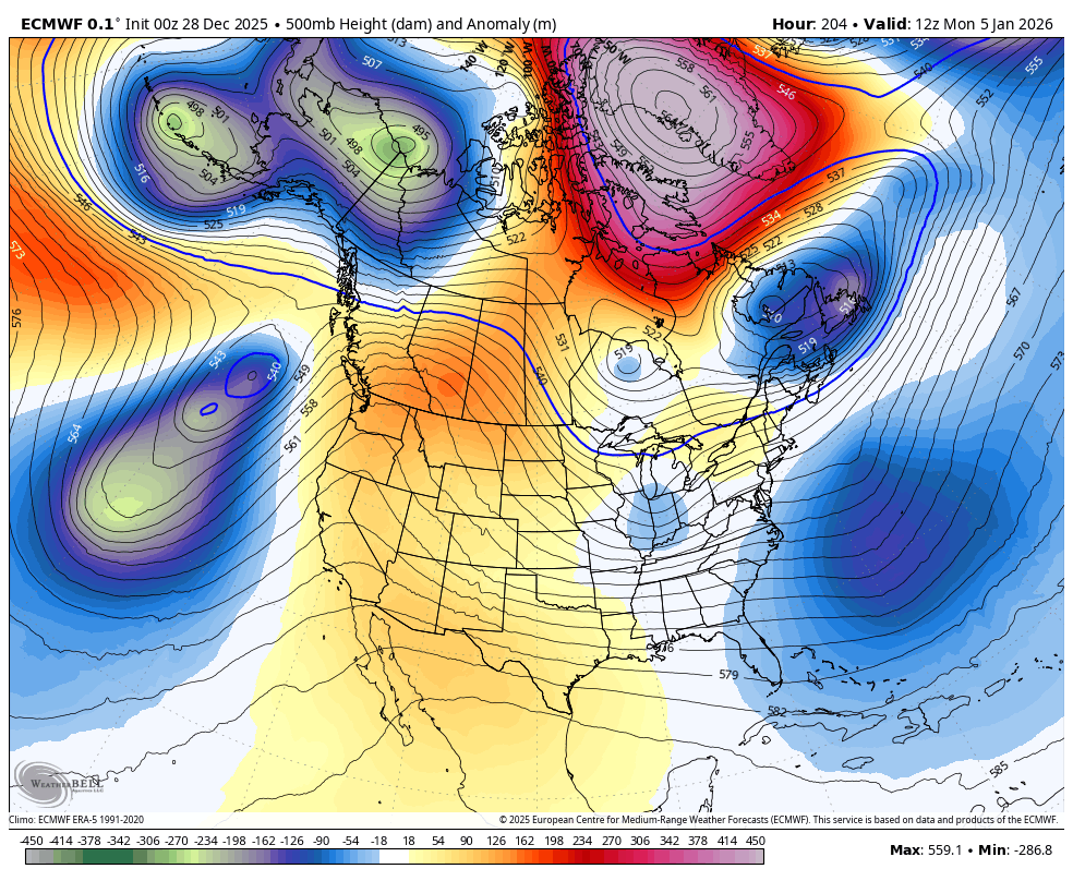
The massive blocking going up in the high latitudes later into the first week of January can lead to extreme setups under it across the eastern half of the country. The EURO is going straight to that possibility. Watch this massive system get cut off under the block and then get’s reenforced by another trough diving in at the end of the run…
Looking farther down the road via the Euro Weeklies, we continue to see them rapidly trending toward another very wintry setup for the eastern half of the country into January and early February.
The EURO Weeklies are comprised of 101 different members so what we see is the average from those members, so things are pretty smoothed out. Knowing that and seeing this massive -NAO block showing up for January is impressive…
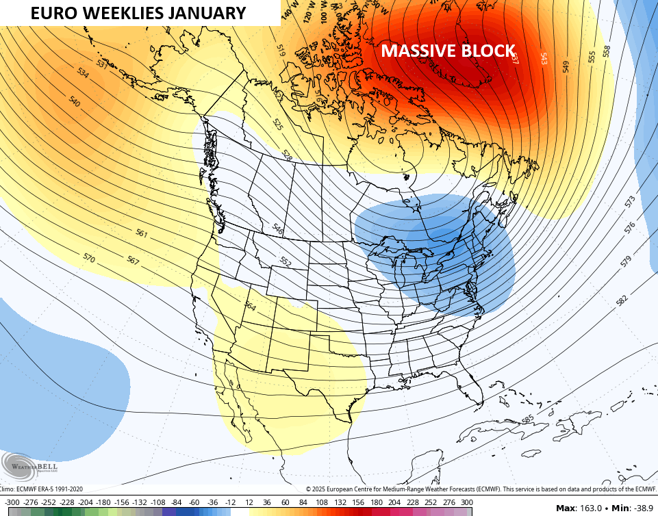
That kind of a block typically causes some wild winter weather times underneath it across the eastern half of the country. It’s good to see the Weeklies heading toward the pattern I’ve been describing.
The snowfall average from the 101 members are based on a 10-1 ratio and look like this…
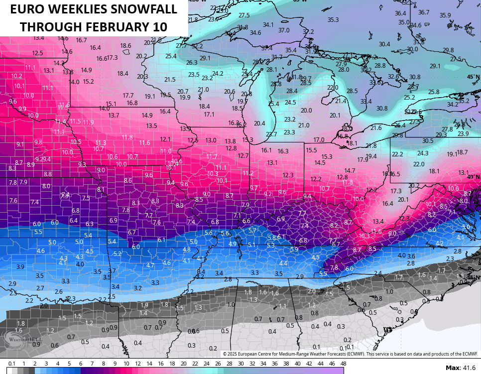
That’s a healthy snow look this kind of model.
Buckle up, winter weather weenies.
I’ll have updates later today so check back. Until then, here are all the storm tracking tools you need to start the week…


Current watches

Possible Watch Areas

Make it a great Sunday and take care.

I don’t think we see much. These models will be wrong.
They always are Jeff. Just a guide to nothing.
Ski resort in Mineral, Colorado. Folks, there are areas in the CONUS that actually have Winter weather when were suppose to have it. Not looking forward to another frigid, and dry Snowless week ahead. Here’s the link to a Beautiful Snowscape : )
https://www.ventusky.com/webcam-150967988
Another Beautiful Snow scene at a Ski Resort Whitefish Summit. I couldn’t resist to share, because of all the Snow covered Fir and Spruce trees, with the Mountains and clouds in the background : )
https://www.ventusky.com/webcam-844060209
Right now my PWS near Bowling Green reports the current temperature is ridiculous 75.4°F, the dewpoint is 62°F, and I’ve recorded a peak wind gust of 32 mph. This crazy mixed up La Nina winter has me thinking Spring and a sizeable uptick in severe weather.
I agree Joe, we already had a confirmed report of an EF – 0 Tornado on the 18 th of December. It did some minor damage to buildings, and trees uprooted about various properties. Looks Tornadic for late this afternoon maybe ?
NWS link of the EF – 0 Tornado in Larue County on the 18th, December 2025 : )
https://forecast.weather.gov/product.php?site=lmk&product=PNS&issuedby=LMK
The Climate Impact Company latest. Shows all the Winter weather, which looks Severe in the Northern border States into Canada : )
https://climateimpactcompany.com/u-s-sunday-report-cold-is-back-week-4-plethora-of-hazardous-weather-events-start-the-week-2-2/