Good Friday, everybody. Here’s hoping this post finds you guys living your best life. In terms of the weather, we have been living our best lives with mild temps but that’s about to come to a crashing end. Strong storms are rumbling early today ahead of another dramatic change that brings in winter late this weekend.
Let’s begin with today.
A line of showers and thunderstorms is rumbling across central and eastern Kentucky this morning, bringing some big time winds with it. Gusts of 40mph or greater are likely in many locations and this may cause some issues.
The chance is there for a few severe storms very early today and the Storm Prediction Center is highlighting it…

Temps along and ahead of our cold front are well into the 60s but will drop into the 50s in the west and north later today.
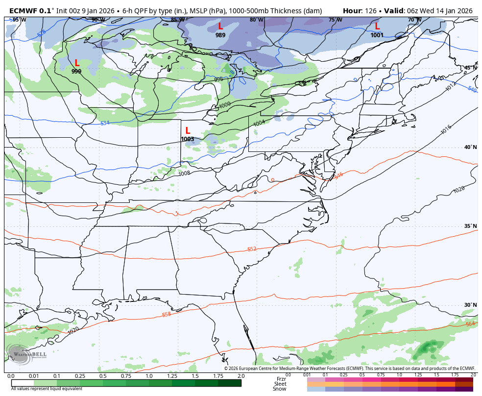
This front stalls on top of us tonight with another low pressure rolling along through early Saturday. Rounds of heavy rain target the eastern half of the state with lighter amounts farther west. Once this goes to our northeast Saturday afternoon, temps crash from northwest to southeast.
An upper-level system then drops in here on Sunday, bringing periods of light snow and flurries. This animation from the Short Range Canadian shows the flakes well on this animation that starts at 7pm Saturday and ends at 8pm Sunday…
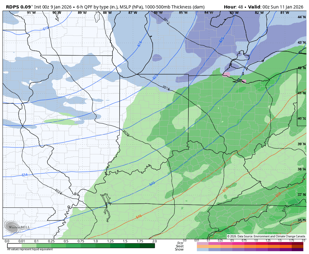
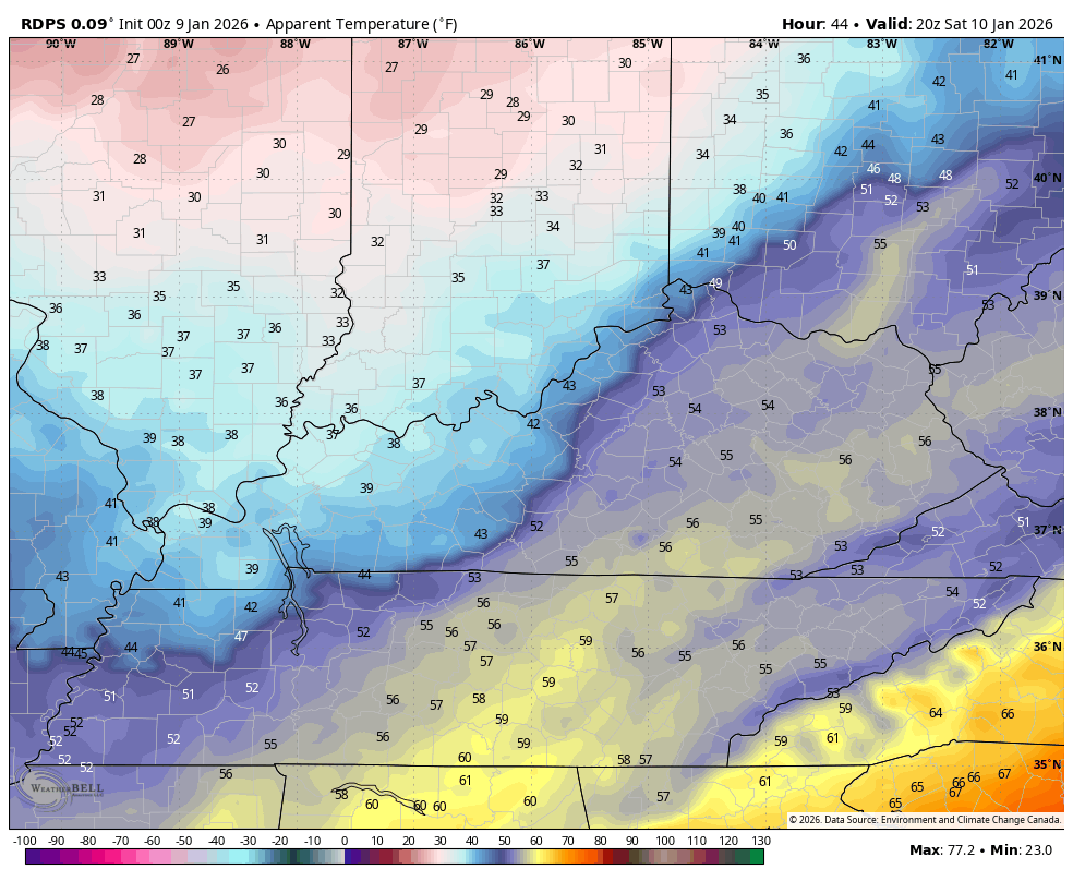
Temps crash during this time with temps staying in the upper 20s for much of Sunday with wind chills deep into the teens. Check out the dramatic drop in those wind chills from Saturday afternoon through Sunday morning…
I’ve been talking for a while about how the setup next week will feature several systems dropping in from the northwest with the chance for one or two of them to blow up into big winter systems.
Now, the models are seeing this possibility but it’s important you understand what forecast models in this time frame are good for… Trends. Nothing more, nothing less as the details change from one run to the next.
Our first system drops in late Tuesday into Wednesday and looks like rain to snow as arctic cold drops in. Can we develop a stronger storm system out of this setup? Yes, but that’s not a certainty.
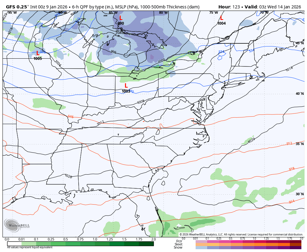
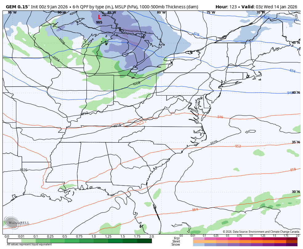
That will be followed up by a more impressive looking storm about a week or so from now.
This run of the GFS has an “old school” look…
The Canadian is trying to get there, but it’s much lighter…
The EURO is also going toward an old school looking storm but is farther east than the GFS…
The with both of those has my attention, folks.
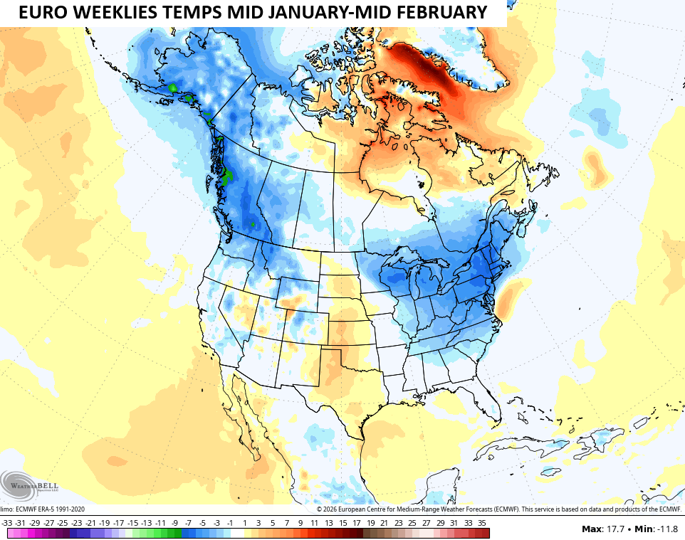
The EURO Weeklies continue to trend toward another cold and snowy setup for much of the country over the next month or so. Check out the temp anomalies across North America next week through the middle of February…
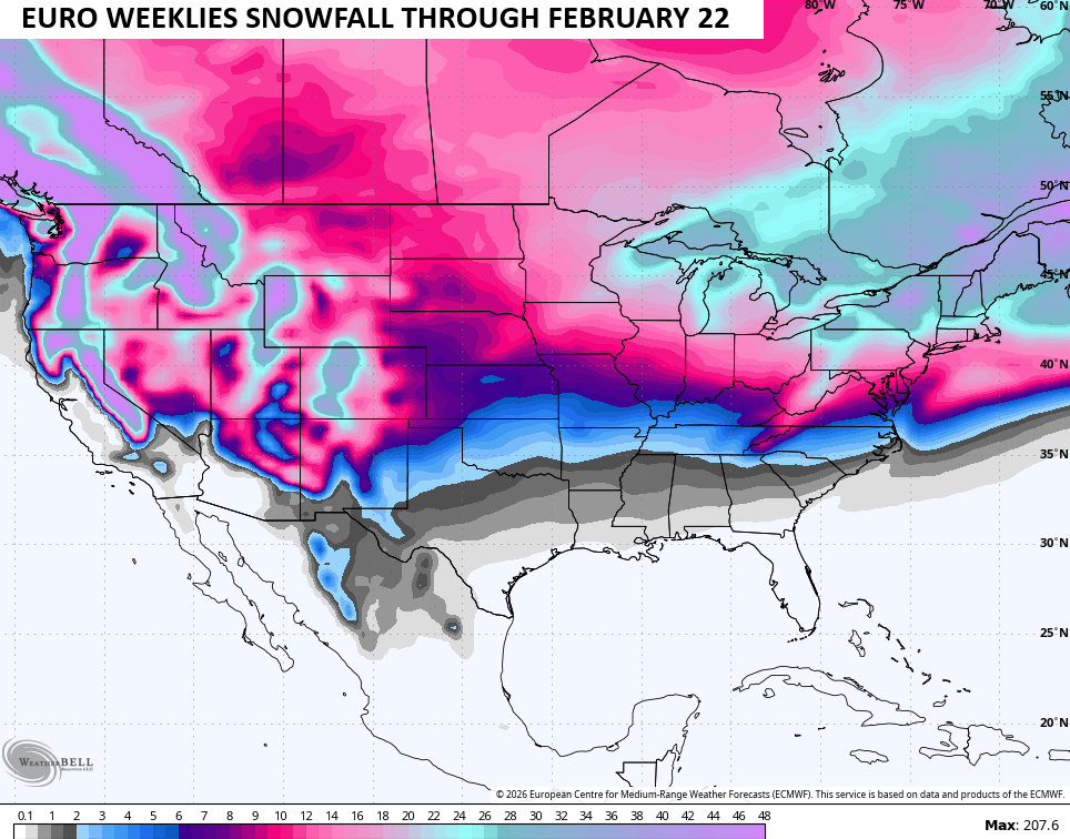
The snowfall forecast goes through February 22nd and continues to show a lot of the country with increased snow chances…
We shall see.
The main update comes your way later tonight. I’ll also have a few updates on my Meteorologist Chris Bailey Facebook Page . Until then, here are all the storm tracking tools you need to start the week…


Current watches

Possible Watch Areas

Make it a great evening and take care.

I think we get maybe a total of 15″ snow before winter is over.
I can’t see that much Snow accumulating anywhere in Kentucky, especially in an La Nina Winter.
Thanks Chris. With this first round of Rain / showers, we ( Maple ) received only .13 “. Hope the next round is much more ? As we are below normal in moisture, and WAY ABOVE normal in Tempertures. A high temperature forecast today is 67 degrees. More like April than January weather. I found an area in Ontario, Canada that actually has 4 seasons. Blue Mountain Village. Looks like a pleasant place to retire. In my opinion, weather forecasting is getting more inaccurate due to AI’s influence. I don’t think they ( Scientist ) are factoring in the various Oscillations and what phase of ENSO we are currently in.
Link to a Perfect Climate, Blue Mountain Village, Ontario, Canada. Shows the Ski Resort, and the Beautiful Village, with A Very Snowy landscape : )
https://www.ventusky.com/webcam-143600639
Link to forecasting our next ENSO phase. Not to confident on their forecast : )
https://climateimpactcompany.com/january-2026-enso-outlook-la-nina-ending-next-1-3-months-confidently-forecast-entering-springtime-prediction-barrier-indicates-mid-to-late-2026-enso-forecast-uncertain-2-2/
The CPC has released the January ENSO outlook, stating that there is a 75% chance for ENSO Neutral to develope over the next 3 months. The weak La Nina remains in effect, based on current sea surface temps and wind directions at mid and upper levels. Weak La Nina effects may persist initially during that period. The report hints at the possibility of El Nino development later in the year, but since the long range models upon which this hint is sourced have been so unreliable in recent years, that projection is likely to be premature!
” Unreliable in recent years, ” due to Artificial Intelligence influences in long – ranged Model weather forecasting.
Also, the current model algorithms incorporate constant values in their forecast calculations. The values for these constants were developed during a period when atmospheric temperature and humidity levels were relatively stable. But over the past few years, the increase in atmospheric warming and the rise in relative humidity is unanticipated, and is affecting the model calculations. The effect is minimal when the model is looking at forecast periods a few days into the future, but the amount of error introduced steadily increases when forecasting weeks or months into the future. In a sense, the input data that the models receive vary from what the programs expect, introducing error in the forecast calculations.
I really don’t know how weather forecasting will be as we go forward into the future, but it seems to me, weather forecasting back in the early 1960’s was much more accurate. Giving only 3 day weather forecasts. Now they can’t tell the weather within the hour, let along 3 months out. They seem to ignore that we are in a La Nina pattern, and lead us to believe that heavy Snowstorms come from the Northwest, unless one lives on the lee side of the Great Lakes then it may happen. Our major Snowstorms come from Gulf Coast Low pressure systems merging with negative pressure from the Northwest ( Polar Systems. ) This Winter there is Low Pressure in the North, and High pressure to our South, which is called ENSO / La Nina, ( below normal Snowfall for our area. ) A few Winters we have High Pressure to our North, Low Pressure to our South, which is called ENSO / El Nino. Snowfall chances increase for our area. Then and only then.
Thursday turned out to be one of the wettest January days in Chicago weather history. A large area of heavy rain moved through the Chicago Metro Area early Thursday evening, with 2-inch totals common. O’Hare Airport received 1.92 inches, which set a daily precip record, Midway Airport 2.06 inches, and the NWS office in the SW Suburbs 1.94 inches. A Flash Flood Warning was issued for much of the area Thursday evening.
Meantime, temperatures soared to 60 degrees just before midnight Friday, just missing the record high for Thursday by three degrees. The temp was at or near 60 degrees for a few hours Friday morning, and we at least tied the record high for today’s date.
It’s a lot cooler this afternoon, in the mid-40s, which is still well above normal.
Mike, It’s been a very Dry and Mild, Uneventful January. We may receive a decent rain late tonight or early tomorow ? I just don’t know how this weekend will turn out. I think the amplified High Pressure Ridge to our South and East will weaken any Severe Weather that is predicted to occur. You’re North of the La Nina Jet Stream, is why the heavy Rains in the area.