Good Tuesday, everyone. We have a small winter weather maker rolling in later tonight into Wednesday. This is the appetizer for a MUCH bigger system arriving this weekend. That may very well be upgraded to a Winter Storm THREAT today.
Let’s start with today and roll forward.
Bitterly cold temps are out there this morning with single digit temps and wind chills below zero in many areas. These kinds of wind chills are dangerous if you have to be outdoors for an extended period of time.
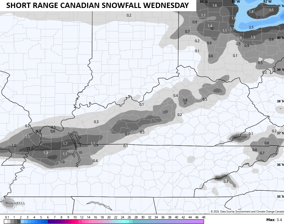
Clouds roll in later today ahead of a light snow and light rain maker moving in late tonight and lasting through Thursday morning. The chance is there to put a small accumulation down Wednesday. Since the Canadian has the hot hand with short-term systems, let’s ride it…
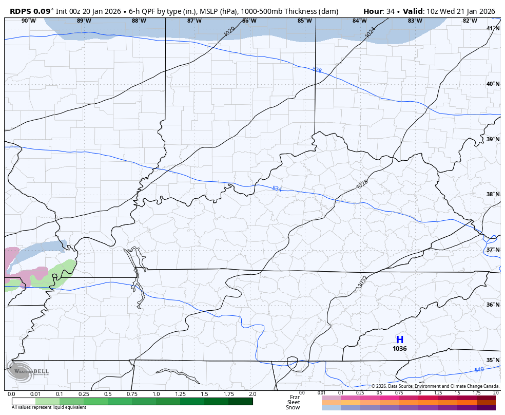
The best chance for some light sticking stuff early Wednesday is from western Kentucky into central Kentucky…
That brings us to the increasing potential for a manor winter storm to hit our region this weekend.
Here’s an updated list on what you need to know:
- The timeline on this is late Friday night through Monday.
- Brutally cold air sweeps into the northern half of the country later this week and slowly presses south and southeast.
- The exact positioning, strength and timing of this brutal cold will be the main player on how this whole thing plays out.
- I’m still thinking we get two actual storm systems.
- The first lead low likely rides into the southern Appalachian Mountains before the big daddy low takes over right behind it.
- If this is indeed the setup, look out. Significant snow and ice accumulations would show up this weekend.
- How much and exact details are a way away from being known as that will all depend on the exact track of each low.
- This may wind up being a prolonged storm.
- Areas getting in on snow from this may experience snowfall ratios off the charts as temps right behind this boundary will be in the single digits and teens.
- Low temps can go below zero over the weekend and early next week with dangerously cold wind chills possible.
- Given the magnitude of this system, a Winter Storm THREAT may be required later today.
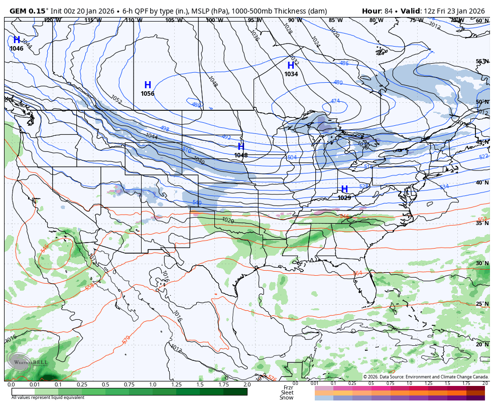
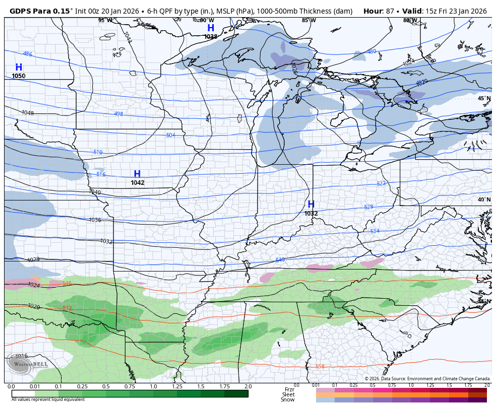
All the models as of this writing continue to trend toward a massive winter storm hit for our region. The Canadian is going toward my idea of tracking a lead low into the southern Appalachian Mountains before popping the main low. Here’s the wide view to show this monster…
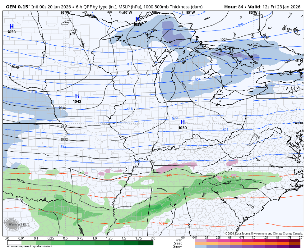
The up close and personal view of the Canadian…
The Parallel Canadian showed that scenario first and it continues to show it…
The EURO is also all in on a massive winter storm. This animation runs from Friday afternoon through Tuesday morning…
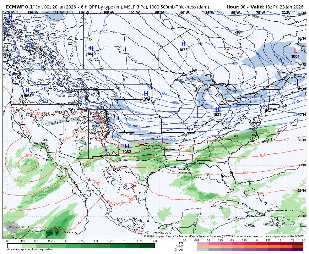
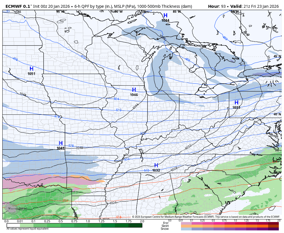
Here’s how that same run looks up close on our region…
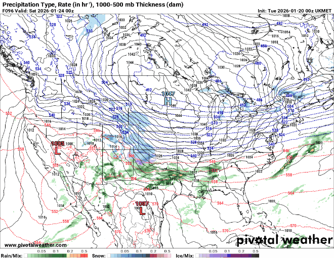
The UKMET is similar…
The GFS had been well to the south and southeast, but as you guys know by now, it always trends north and west. Compared to earlier runs, this trended WAY north and west and isn’t done…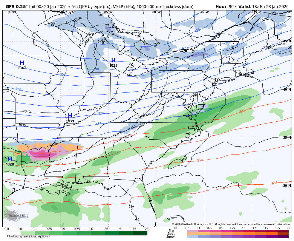
Once this goes through, we need to watch the middle and end of next week for another potential deep trough that can spawn another big system.
Several updates come your way today and I’m back on WKYT-TV starting at 4pm. I’ll also have a few updates on my Meteorologist Chris Bailey Facebook Page
Until then, here are your tracking tools for the day…


Make it a magnificent Monday and take care.

Snow dance in 5..4..3..2..1…..
Off run of the Euro..Just goes out to 144..
https://imgur.com/eWk9F9F
Wouldn’t surprise to see models still come north some..Hopefully the Canadian trends this way..No ice..
I hope this ends up a major bust.
Thanks Chris. The First Storm Track Will Determine The Second, So I’m Not Quite Sold On A Major Snowstorm For This Coming Saturday. Lets Get Through This One, Before We Start Discussing The Weather Type For The Weekend After Next. I Don’t Think The Various Models Are Factoring In, That We Are Still Having Impacts From La Nina, Though It Is Starting To Phase Towards ENSO / Neutral. Those Models You Displayed This Morning Are What One Would Expect In A Weak El Nino Phase Of ENSO, Which Has A Very Active Subtropical Jet Stream. I Have Never Experience A Major Snowstorm In A La Nina Winter, but I Experience One Of The Worst Ice Storms In January, 2009 ( A La Nina Winter. ) Maybe This Will Be My First La Nina Snowstorm, But I Still Have My Doubts.
Latest From The Climate Impact Company : )
https://climateimpactcompany.com/u-s-early-notes-timing-the-incoming-arctic-air-and-as*sociated-weather-hazards-2/
i like see a bust, but bailey in your old blind age your slipping. this should already be in THREAT MODE. your slipping.
Incorrect take
Use To Be : ” Winter Storm Watch, ” And When It Happens It’s Upgraded To A ” Winter Storm Warning. ” Little Early To Issue Such, In My Opinion.
Just snow and no ice and I’m fine with the weekend storm.
This system has been on the models in one way or another for a few weeks. Hey Schroeder why don’t you start your own weather blog since you always doubt and know more that our chief Mr. Bailey. Get exhausting with your diatribe.
I Know, I Just Have My Own Opinions. I Always Love To Discuss The Weather With Those That Are Interested In Meteorology. I’m 75 Years Old This Year, So If I Was Younger I Would Attend Purdue University, And Earn My Degree In Meteorology. Then Maybe Start My Own Weather Blog.
I understand and that snow drought you have been in has you cranky. Hope you get some this weekend.
Shut up
If this verity’s it be a firs time t since 2015 that the whole state is involved.
Should be verify