Good afternoon, everyone. Light snow and a light mix are winding down after causing travel issues earlier today. As this fades away, we turn can firmly concentrate on the major winter storm coming this weekend. Our Winter Storm THREAT continues with an early upgrade to an Alert likely by tonight or early Thursday.
Here’s a quick breakdown of our THREAT…
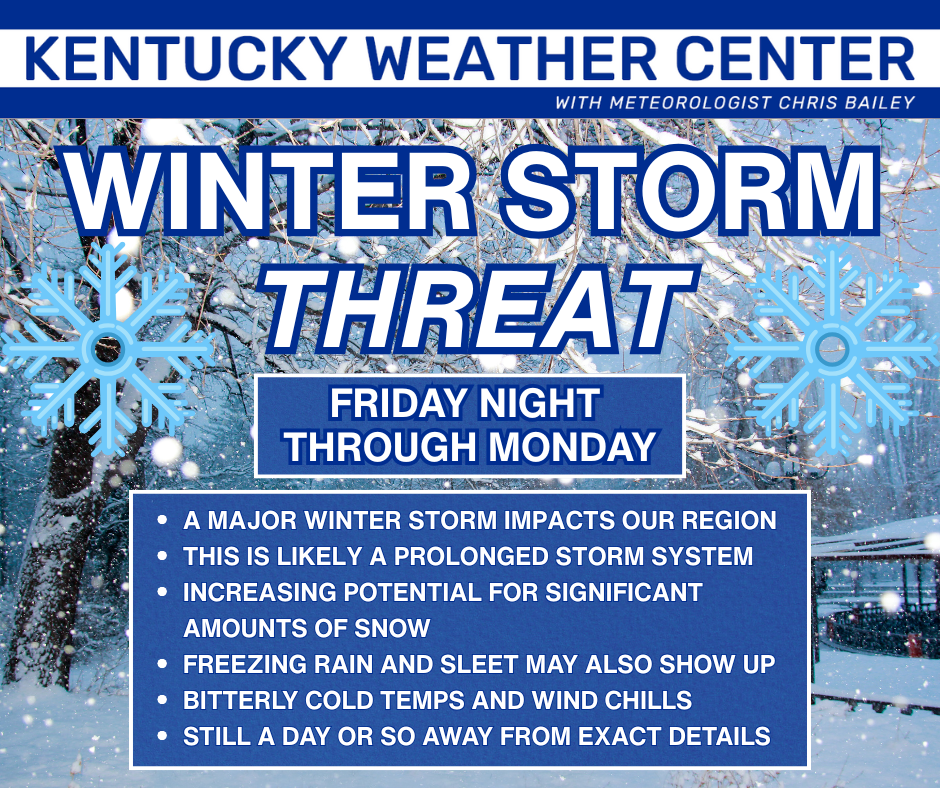
A Winter Storm WATCH has already been issued for much of Kentucky for the weekend. Kudos to the NWS folks for getting out ahead of this with headlines days in advance!!!
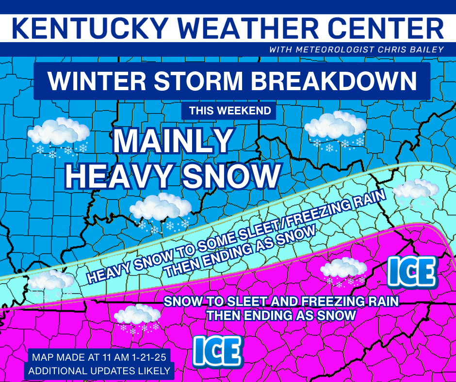
Here’s my initial breakdown of how this may play out, but this is a work in progress…
This is a likely shutdown winter storm, folks.
I will be updating that later today and on WKYT starting at 4pm.
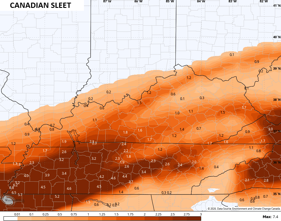
The latest Canadian Model is pretty wound up with this system and brings the lead low through far eastern Kentucky into West Virginia…
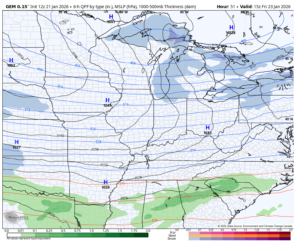
That’s too wound up for my taste to be honest.
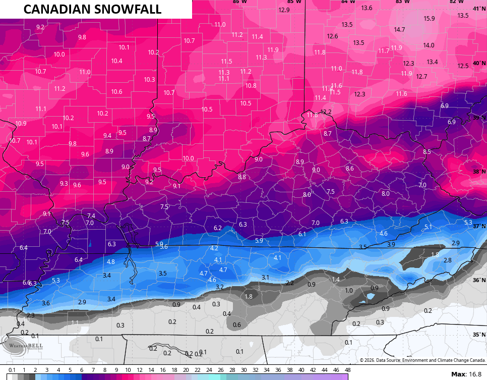
Here’s the snowfall map from that run…
The heavy sleet…
The massive freezing rain shield…
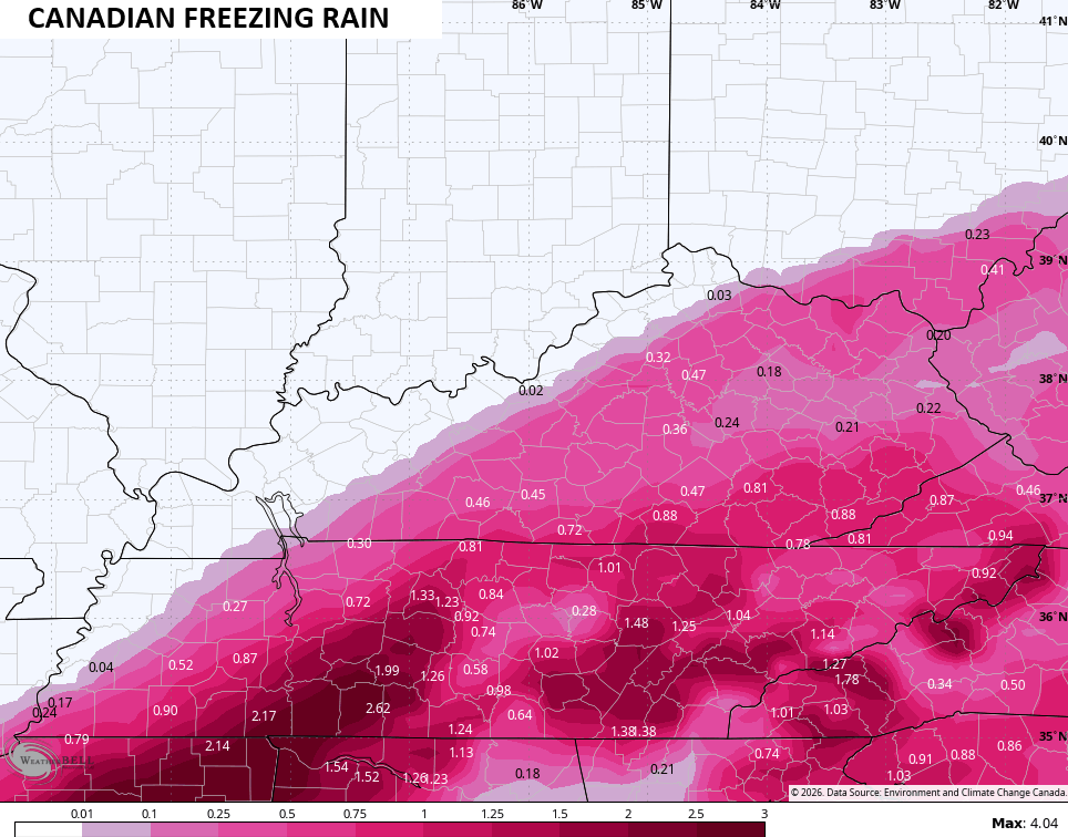
The Canadian is essentially last January on steroids.
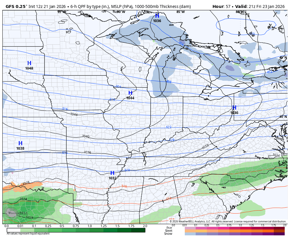
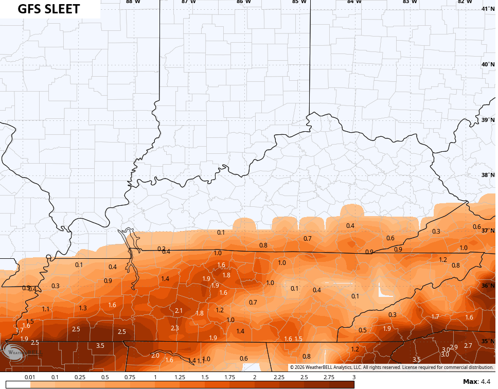
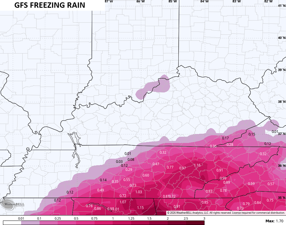
The latest GFS is more of a snow hit than an ice hit for Kentucky, but it’s a close call…
Here’s the GFS Snowfall map that likely has some sleet contamination…
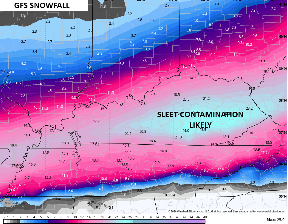
It doesn’t show much sleet, but I think the algorithm is messed up…
It doesn’t have much in the way of freezing rain, which is a good thing, but I’m not sure I fully buy it…
Additional updates come your way later today and I’ll have the latest on WKYT-TV starting at 4pm. I’ll also have a few updates on my Meteorologist Chris Bailey Facebook Page
Until then, here are your tracking tools for the day…


Make it a great day and take care.

Now while I want snow I hope that no one has to deal with sleet and freezing rain.
Well we went from having a good snow in the southeast to ice it never fells. I won’t fall for the hype anymore learned my lesson this time as Chris says it always trends north. That ice looks bad.
We Had Light To Moderate Snow This Morning, And The Temperature At The surface Is 38 degrees. This Tells Me That The Upper Levels Of The Atmosphere Is Well Below Freezing. Great News, Because, That’s Where Snow Is Formed. One Does Not Want Warmer Temperatures In The Upper Levels, And Below Freezing At the Surface. That’s An Ice Event. This Scenario Took Place In The 2009 Ice Storm.
Over The Past Three Weeks, We Must Of Had A Change In The Pacific. I think It Would Be That The Warm (Kelvin Wave ) Made It To South America’s West Coast. The Startings Of ENSO / El Nino. Would Explain An Increase Strength In the Subtropical Jet Stream.
Looking At The current Radar, That, Moisture Plume From The Southwest Is the Subtropical Jet Stream, and It’s Full Of Moisture. It’s Too Bad It’s Going Through Kentucky, As This May Be The Storm Track. Makes Sense Now, That Back Home In South Central Indiana, We Always Had Many Snowstorms, Because We Were North Of The Storms Track, Like Chris Has Indicated On His Latest Map. Look At it this Way, We May Be in The Dry Slot Or Just Plain Rain. Would Suite Me Just Fine. Don’t Want Any Ice !!!
Ice is what I am afraid I am getting Schroeder how much I guess remains to be worked out. It looks like we still get some snow Saturday but Sunday looks like ice. I will have my usual cold rain over the ice please lol.
Crystal, When I Saw all That Heavy Snow In Indiana, I Knew That The Storm Track Has Shifted North, And Leaving Us In The Warmer Sector Of The Storm, With Maybe Back Side Snow Flurries, As The Storm Moves East / Northeast.
last night during broadcast im not worried about ice ole bailey said. are you worried now. lets pray the GFS is right.
Shut up
The GFS is spitting out astronomical snow amounts through the first week of February! It’s been not aggressive enough or too aggressive for the last couple of weeks! What’s up with with that??
The GFS Is The Worse Weather Model. Those Snow Amounts Are Over Inflated.
GFS is not picking up the advection component that will likely put Lehigh Cty in line for a sleet, ice and some snow hit. Ice could accumulate 3/4 of an inch or more.
Joe, At This Point I Hope It’s All Just Plain Rain.
There’s still a major difference in the computer models as to who gets the heaviest snow and how much. One model shows the Chicago area and Northern IL getting between 8 -10 inches, while another model shows just a few tenths of an inch for Northern IL.
We are preparing for the brutal, extreme cold that’s predicted here beginning Thursday night.
Mike, I’m Sure That Indiana Will Receive The Most Snow Out Of This Storm. North And Northeast Kentucky Will Too, But not As Much As earlier Predicted. Northwestern Kentucky Too Will Receive The Heavy Snows. My Area Will Probably Be In The ” Dry Slot ” Of The Storm. Every Storm Has A ” Dry Slot. ” It Doesn’t Matter How Large The Surface Low Is. It’s The Track The Low Follows That Determines The Weather Type. North Of The Track : Heavy Snow, South Of The Track : Rain, Sleet, Freezing Rain And The ” Dry Slot, ” Hopefully With Warmer Temperatures, Until The Arctic Front Pushes all This Garbage East. Not looking Forward To Any Of This. I Don’t Know Why The Whole State Of Kentucky Can’t Receive The Heavy Snows. The State Is Not In A Good Location Geographical For Major Snows. Too Far South.
This one just may defy those trends. Lots of cold air to work with and a late phase will do that. Still early to predict, but the odds of an all Kentucky big snow is def above 60% IMO…We will see
Actually, it looks like that KY is in the bullseye for huge amounts of precipitation, much of which will be snow. I sincerely doubt there will be any “dry slot”.
Mike, There’s A ” Dry Slot ” In Every Complete Storm. Has A Comma Shape To It.
Temps in north will be quite cold with higher ratio snows. I don’t see this as an ice event for the river counties, but the parkways could def change. Warm air over the cold ground is never good and let’s pray not ice storm repeat.
I would def wait for both of these lows to get onshore before I get excited. The timing of each will have a critical play on when and where the heaviest snow occurs. We def don’t want this to phase over Arkansas or we could all be in the rain.
Hopefully the GFS is right.All snow with no ice…It’s not going down in retirement without a fight..USA USA USA
What I Think That Would Be Correct, Was to Wait Until The Storm Became Fully Formed Over Colorado, Texas Panhandel, Or The Western Gulf Region. In The Old Days Of Meteorologist, There Wouldn’t Be much Speculation So Early. In My Opinon, Meteorologist Forecast This Event Too Early. Should Have Waited Until Two Days Before The Event’s Impact. Then One Would Know The Exact Track.
The Blizzard Of January, 1978 Was Predicted Within Hours Of Impact, And The Forecast Storm Track Was Completely Accurate. Go Back To The Old Ways Of Weather Forecasting. The Late Great Marcia Yockey Drew Her Own Weather Maps, And It Was To The Point Of Accuracy. No Weather Models Were Used To Predict Long Term.