Good afternoon, everyone. Our major winter storm is enroute to Kentucky and will shut down the state and surrounding states. This storm will bring significant amounts of snow, sleet and freezing rain with bitterly cold air slamming in as well.
As expected, the Winter Storm Warning has been expanded to include the entire state and most of the surrounding states…

I’m going to be making a New Call for Ice and Snowfall, but I don’t have the time it takes to make the graphic here at home because I have to be at work much earlier than normal. I’ll make it there and get it out to you guys. It may be through my Facebook page.
The models are trending a bit colder and farther south, but that does NOT keep the ice storm threat away in the south and parts of the east. These areas may have a snowstorm to an ice storm then end as some snow.
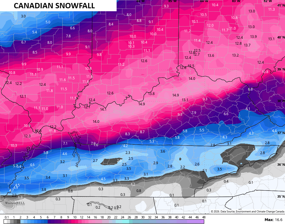
The Canadian Models have had a hot hand this winter so let’s see what they are looking like.
The snowfall…
The sleet potential is still way up there on the Canadian…
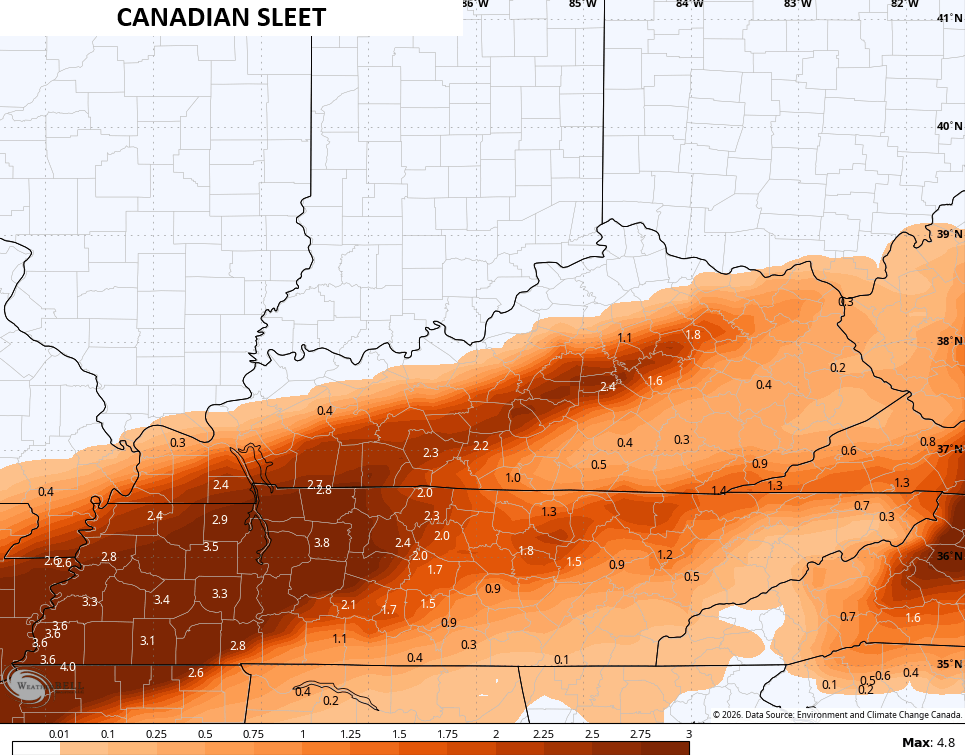
That’s likely too high, but we don’t need that to fall as freezing rain instead because the Canadian is ugly in the southeast and east…
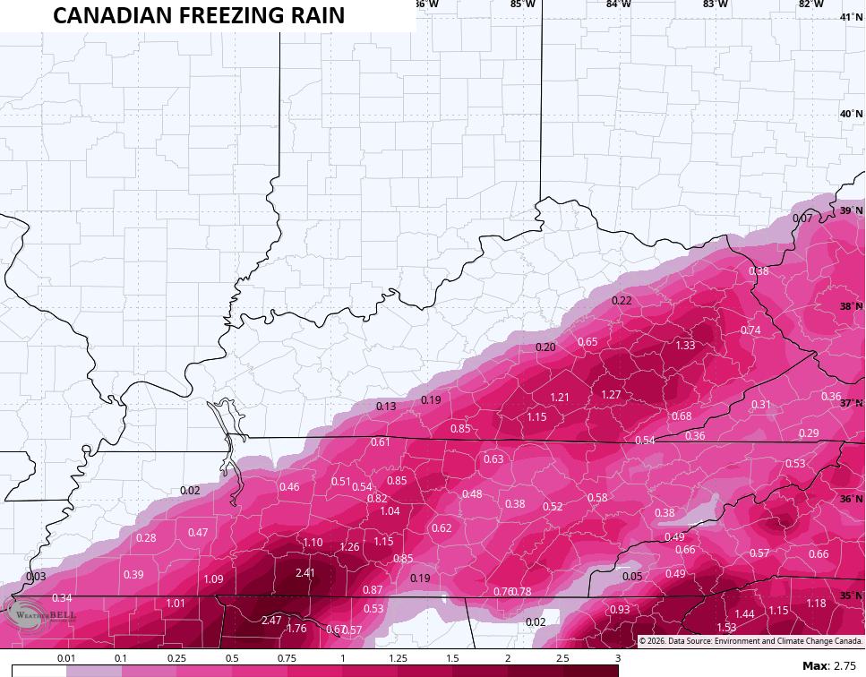
That would be a crippling ice storm for some.
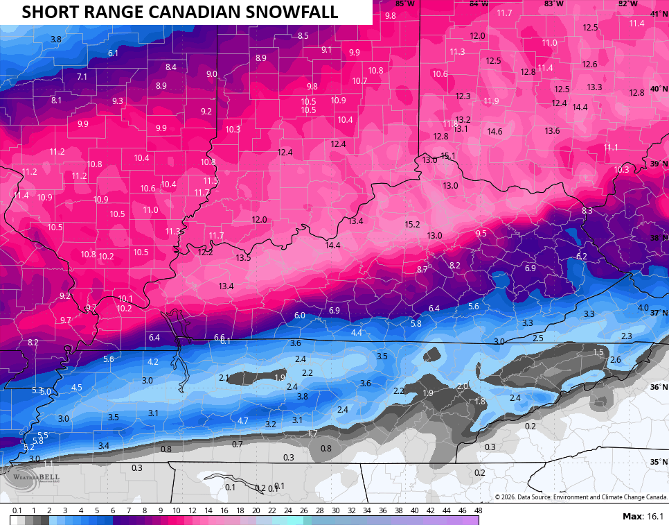
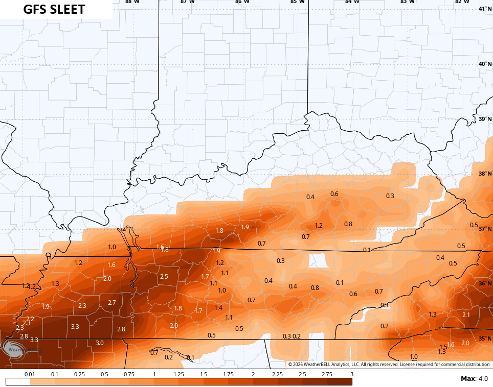
The GFS continues to be the snowiest model known to man and it has not wavered from that…
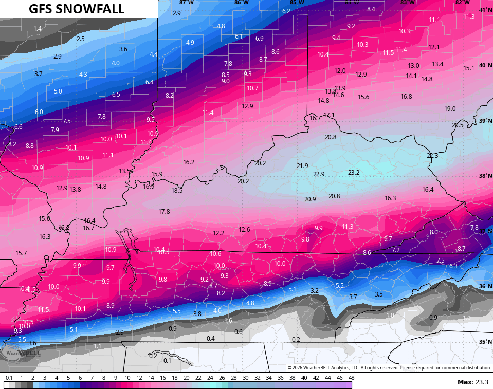
It does have some sleet…
The freezing rain is more confined to the southeast…
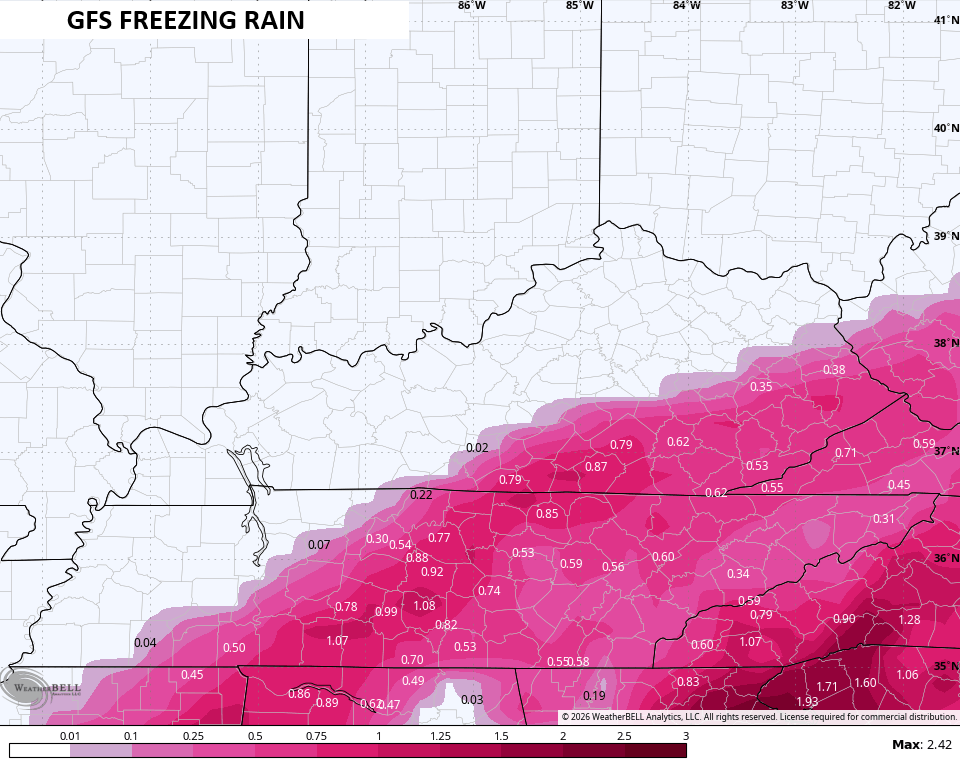
That would still be a major ice storm hit.
Here’s hoping the farther south trend continues on the models as that would mean less ice and more snow.
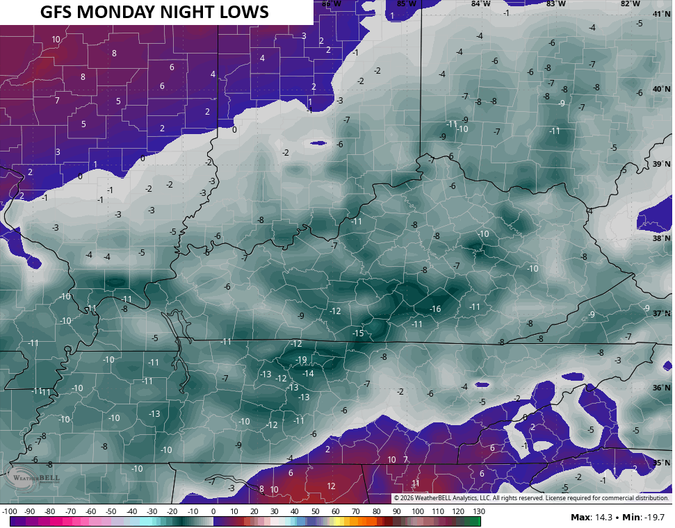
This is a life-threatening storm and the brutal cold with it will also be life-threatening. Lows go well below zero Monday night…
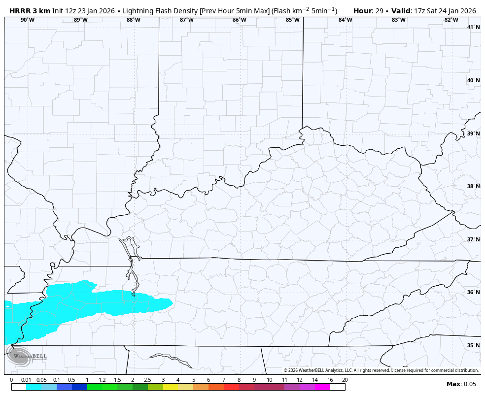
BTW…The HRRR only goes through 7am Sunday and sees the chance for some thundersnow or thunderice…
That’s wild!
I’ll have updates through the day and on WKYT starting at 4pm. I’ll also have a few updates on my Meteorologist Chris Bailey Facebook Page
Until then, here are your tracking tools for the day…


Make it a fantastic Friday and take care.

Not many times have I seen the entire state of Ky in a WSWarning. I hope the GFS verifies and we all know it is always on the high end, but never comes to fruition. Nevertheless the river counties are going to get hammered. Too bad I am in South Carolina and won’t get to enjoy it. :(.
Check on your neighbors. The arctic cold is very dangerous.
Be safe and be prepared.
Where is Rolo, BubbaG, Winterlover, and all the other old school snow lovers. This one is an epic event and i figured the KWC would be shut down with comments.
BubbaG is oddly absent.
im here bjenk, hey bailey how it trending south and colder with candien showing over a inch of ice se. that aint colder. cmon
im here brother, most bloggers are dreddong ice and are not excited.
Yep! Don’t blame them. My peeps in Louisville are def gitty about this storm. Once every 10 years for something like this.
I don’t want ice either Rolo good to talk to you!!
The HRRR + Icon Model, Has Maple Receving 4 ” Of Snow On Saturday, And 13 ” On Sunday. We Shall See. I Still Don’t Think This Area Receives That Much Snow, As The Deepest Snow In Taylor County Is ( 12 “. ) Occurred Way Back In March, 1960. Very Rare, But I’am Hoping It Will Be All SNOW. NO ICE PLEASE !!! As I’m Elderly, With Health Problems. This May Possibly Be My Last Winter Storm ? If We Lose Our Electrical Power, Due To Freezing Rain, It Will Definitely Be Life Threating. You Would Think That After The 2009 Ice Event, That I Would Have Purchase A Whole House Generator. That Just Shows Everyone How Stupid I am. LOL….
If The Power Companies, Would Have Burried All Their Electrical Lines Years Ago, We Wouldn’t Have To Worry. It’s Like this Folks, Putting Money Before Lives. How Selfish And Stupid.
Stay Safe And Warm Everyone !!!
Im here hoping WKY gets in on the 10-14 swath and NO ICE.
I’m here Bjenks69 ready for the big thumper snow were expecting here in western,ky. Everyone be safe!
Glad this will be all snow for the Louisville/Lexington area. I’ll be snowed in at home and our daughter will be snowed in at UK with all of her friends and lots of junk food. LOL