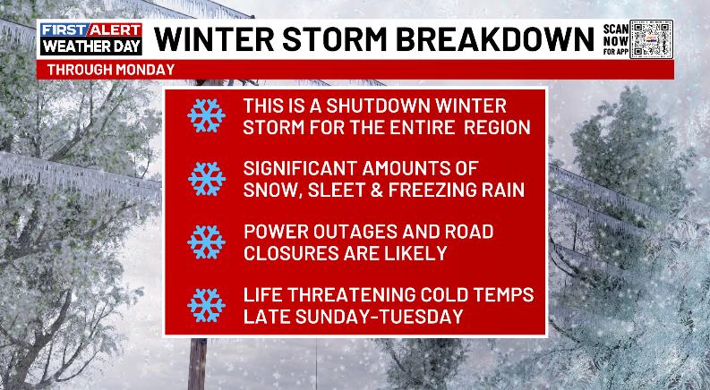
Good Saturday, everyone. It’s go time as a major winter storm moves into Kentucky today. This brings significant amounts of snow, sleet and freezing rain, with bitterly cold temperatures pushing in to add just another layer onto this dangerous storm.
Yours truly will be busy bee this weekend and may not sleep much, if any. I’ll be on WKYT way more than you guys probably want, but that’s the way it goes in these big events.
Here’s the breakdown of what to expect over the next few days…
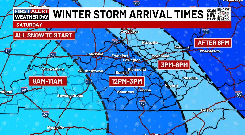
Our winter storm overspreads the state from west to east today, arriving in the south a little earlier than the north. While there may be a small streak of light snow early in the day, here’s a rough look at the timeline for when the snows arrive across Kentucky….
Winter Storm Warnings continue today for the entire region…

I’ve made no changes to my New Call for Ice and Snowfall from Friday afternoon…
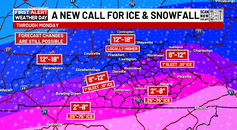
This is a MAJOR winter storm hit. I will adjust things as needed through the day, but the overall theme of that forecast map looks go be in good shape.
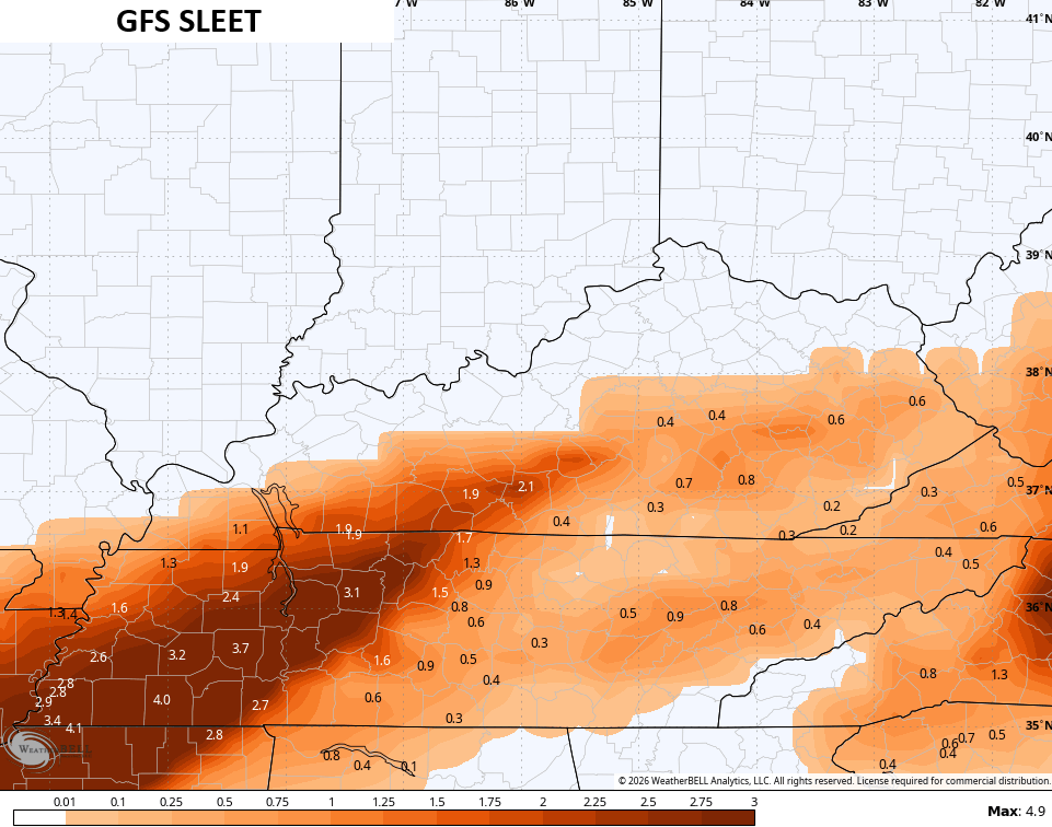
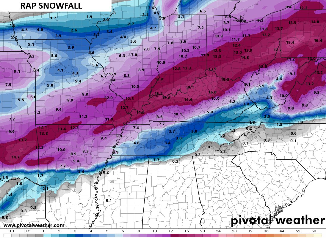
The GFS continues to be the crusher of the bunch as keeps showing quite the area of 20″+ snows…
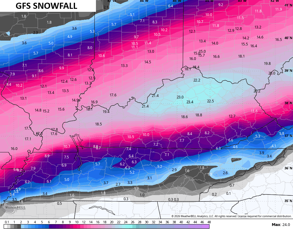
That is likely overdone.
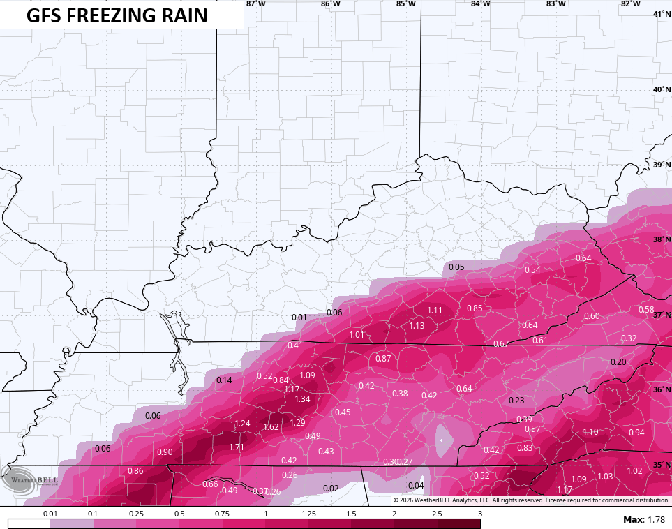
The model is picking up on more sleet than before…
It also follows the concerning trend of some nasty freezing rain across the south and southeast…
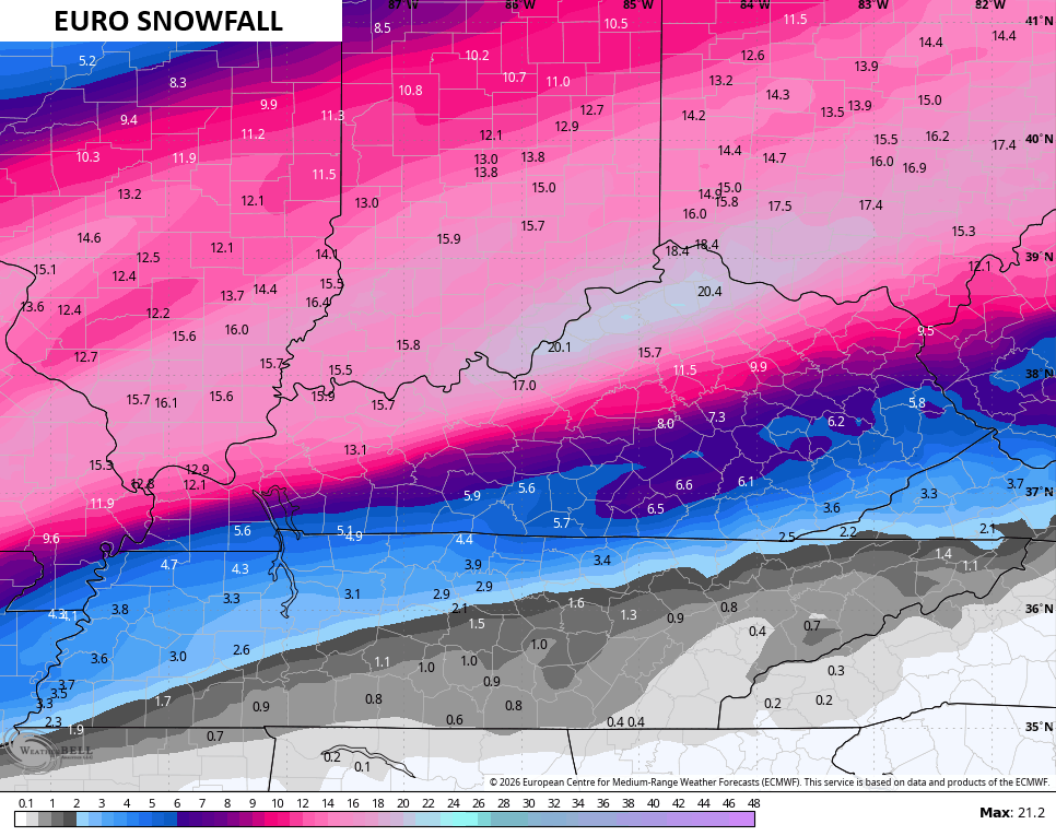
The EURO has joined the GFS in the 20″ snowfall forecast club, but it’s a bit north and an overall much smaller area…
It’s much lighter with the sleet…
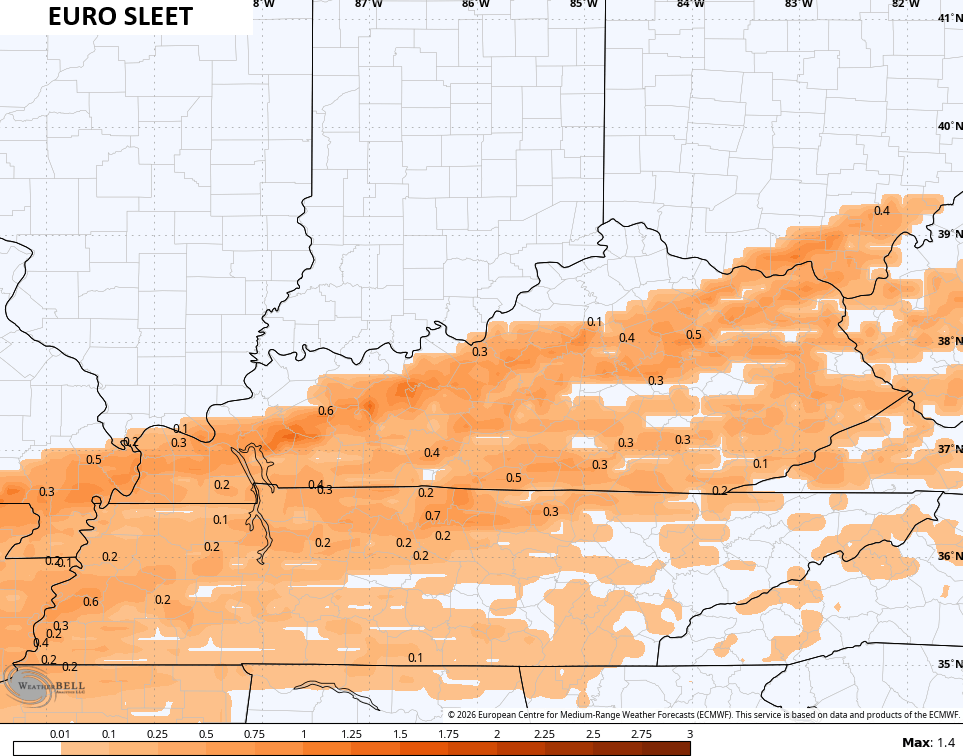
But a lot heavier with the freezing rain and that’s not good…
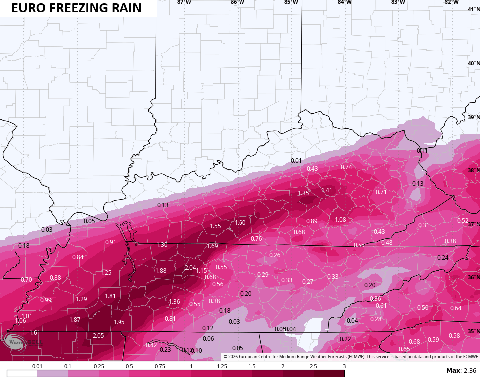
Please don’t even come close to verifying with that.
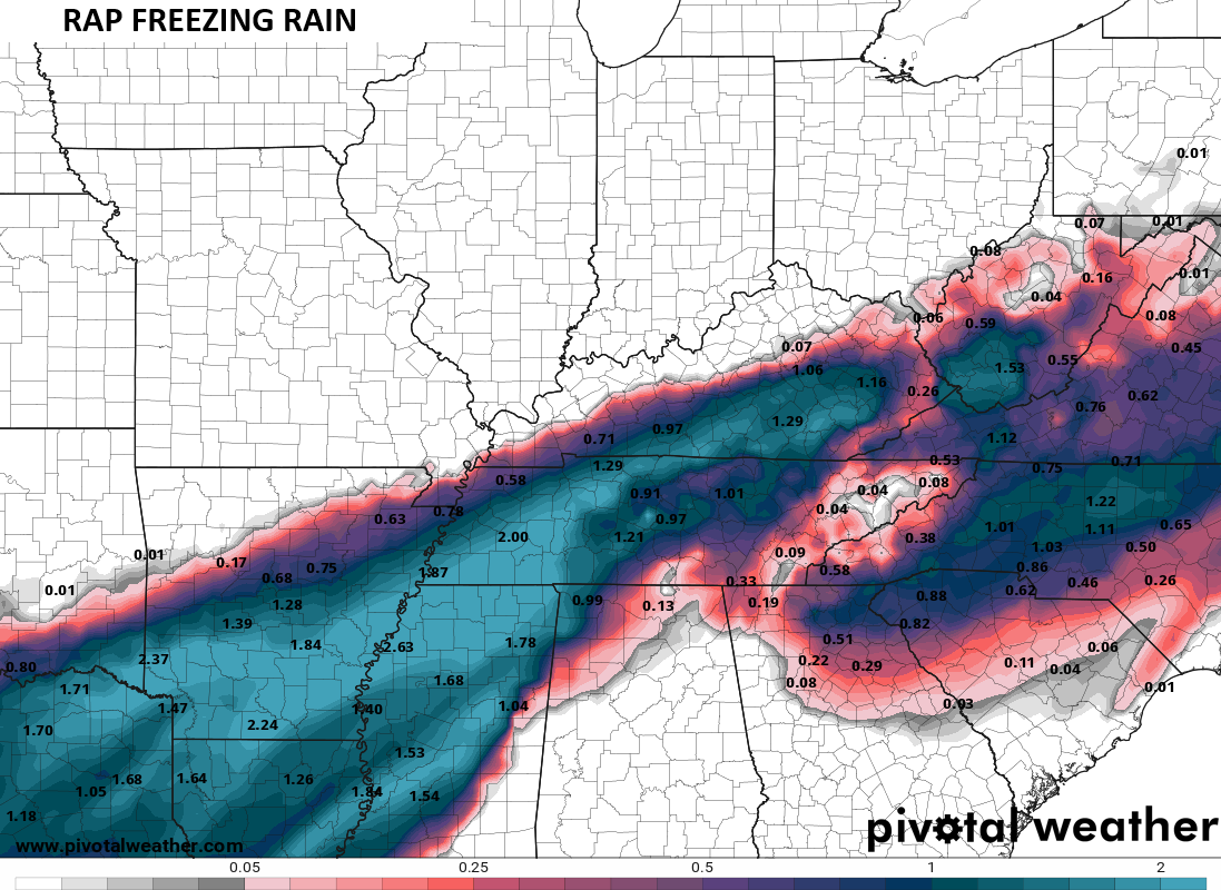
The short range model known as the RAP looks a lot like my forecast with the snowfall…
Once again, we find some ugly freezing rain amounts showing up…
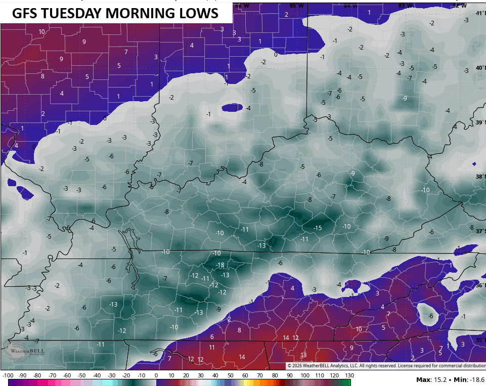
As this winter storm moves away, brutally cold temps and wind chills settle in. Temps likely drop below zero Monday and Tuesday. Here’s the GFS for Monday’s lows…
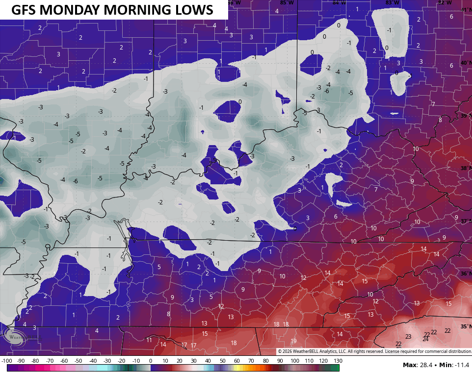
Those numbers absolutely tank by Monday night and Tuesday morning…
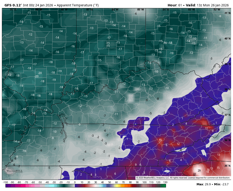
The wind chills will be even colder and likely drop to -20 or lower at times. This wind chill animation runs from Monday morning through Tuesday morning…
I will have updates today when I can. I’ll be on WKYT and WKYT + with continuing coverage starting this afternoon through the life-cycle of the storm. I’ll also have updates on my Meteorologist Chris Bailey Facebook Page
Until then, here are your tracking tools for the day…


Make it a great Saturday and take care.

fire in da holeeeeeeeeeeeeeeeeeeeeeeeeeeeeeeee!!!!!!!!
Now I kinda hope the GFS is right. It gets so much hate, lol.
Bring it!!! And it really doesn’t matter which model is correct as all have a shut down snow and very worrisome ice signature. Hopefully more sleet than freezing rain or more snow than either of them. Stay safe my fellow Kentuckians it’s gonna be a long week. Thanks Chris for all you do to jeep us well informed.
**keep –
Although a Jeep would be nice to have at this time.
Thanks Chris, For All Your Hard Work. I Can Tell You Really Love Your Job. Hoping There Will Be More Snow Accumulations Than Ice With This Winter Storm, And No Power Outages Anywhere.
Stay Safe Everyone !!!
So far we have hit a dry slot, not much snow has fly around were im at in western ky. That second wave that’s coming this afternoon is the one that supposed give the thumper
Will not get nowhere near those ridiculous ice maps numbers..Guess that’s the reason the bread and milk disappears when people see these ridiculous numbers.
We don’t want any part of the Euro freezing rain forecast for Warren County.
1.55″ of ice would be disastrous.
i feel a cold one coming on by motgomery gentry song of day. returns.
Arkansas Snow Scene 37 minutes Ago : )
https://www.ventusky.com/enlarge/index.html?img=25%2F114185625%2Fhour%2F20260124_1500.jpg%3F1769267352
It’s minus 4 degrees here this morning in the SW Suburbs of Chicago, with a wind chill of minus 18. It’s been below zero in the Chicago Metro Area for over 30 hours! Later on today it’s finally going to creep above zero.
Winter Weather Advisories are in effect for parts of the area through Sunday, with between 2 and 5 inches of snow predicted, with higher amounts in the South and SE parts of the metro area. Of course, that’s just a drop in the bucket compared to what you guys in KY are going to get!
Mike, Here In Maple, It’s Been In The Teens For 24 Hours. Snow Is beginning To Fall, And We Have A Good Dusting. Hope The Snow Continues To Accumulate Through The Night.
Everyone stay safe and warm….hope the sleet and freezing rain misses all of you. We’re under an extreme cold warning….dont think we’ve had one of these before here in WKY.
I Never Heard Of An ” Extreme Cold Warning ” Either Russell. I Hope Our ” Snow Drought Ends, ” But My Snow Totals Have Decrease Significantly From Yesterday. We Shall See. This Weather Pattern Has Really Kept Me Guessing.
Here’s The Latest On The Winter Storm Fom The Climate Impact Company : )
https://climateimpactcompany.com/u-s-early-notes-ma*s*sive-storm-is-developing-widespread-hazards-central-and-east-u-s-this-weekend-2/
The Heavy Snow Has Moved Farther NorthTo Include All Of Indiana. Almost All Of Kentucky Will Have Ice On Sunday. I expect Wide Spread Power Outages All Through The State Of Kentucky. Maybe This Time Around The Power Companies Will Begin To Look For A Better Way Of Distributing Electricity? I Have Lots Of Trees On My Property, So I expect The Tree Damage Will Be Horrendous, And I can’t Afford To Have The Property Cleaned Up. I Wish I Never Decided To Retire Here. Another Big Mistake. A Big A*s*s Mistake !
Schroder thanks for the Climent inpact study link. Ill add that to my models folder. Yep looks like another swing/miss for ky and homerun for north of ohio river,again climate has sure changed over the last 20 years . Had a feeling from the beginning that the models where way south with the double ditid snow. I hope we dont get anything like the ice storm of 2003 here in central ky. Hope Maple fairs well . Take care.
Well is the forecast snow gona deliver or fizzle out….
Looking like a bust on snow.
A Dry Slot Is Currently Moving Into This Storm. We Received About An Inch Of Very Dry Snow Since Noon. The Kind Of Snow One Would Expect In A Clipper System.