Good Sunday, everyone. Our major winter storm continues to pound Kentucky with snow, sleet and ice. The ice part of this storm decided to flex and that’s leading to significant issues today with a prolonged period of life-threatening cold moving in.
Winter Storm Warnings continue out there today…

This is a wild storm that’s loaded with as much precipitation as you will ever see in a winter storm. While the precipitation types have been tough to pinpoint for many locations, the intensity and magnitude of this storm have shut down our region.
First and foremost, is the ice storm in progress for many areas of central and eastern Kentucky. Freezing rain is adding up and we may very well have big power problems by the time you’re reading this. The worst fear of this storm was for freezing rain to become a bigger issue and here we are, folks.
Just north and west of the freezing rain is a zone dealing with heavy snow, heavy sleet and some freezing rain. These areas may even alternate between the three for much of the day before snow takes control again.
North and northwest of this is the area with a major snow storm. The area I talked about in northern Kentucky is getting in on the major snows as they stay snow or mostly snow.
Everyone sees light snow and snow showers from late this afternoon into tonight as the major winter storm pulls out of town. That’s when brutally cold air slams in here, leaving us in a life-threatening situation, especially for people who may be without power.
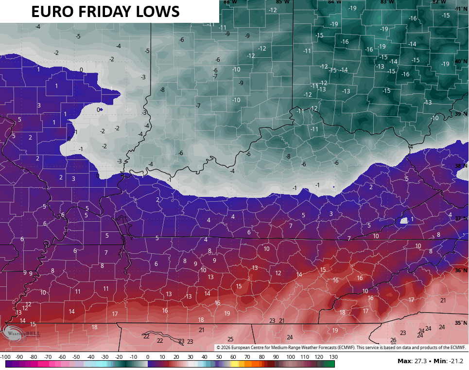
Lows tonight into Monday look to drop toward and below zero…
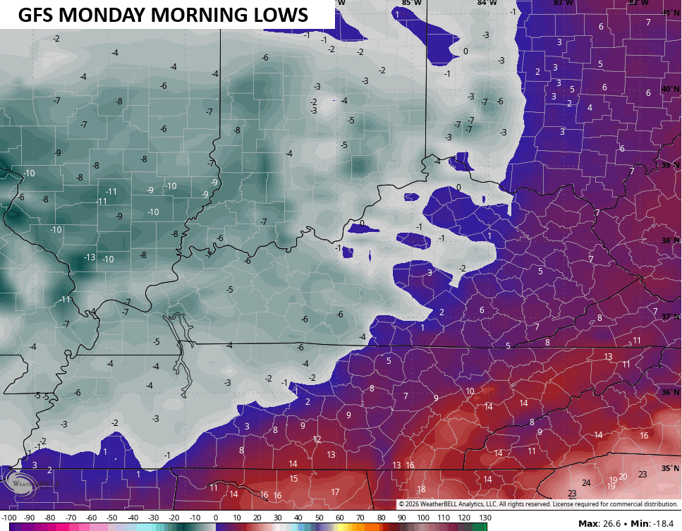
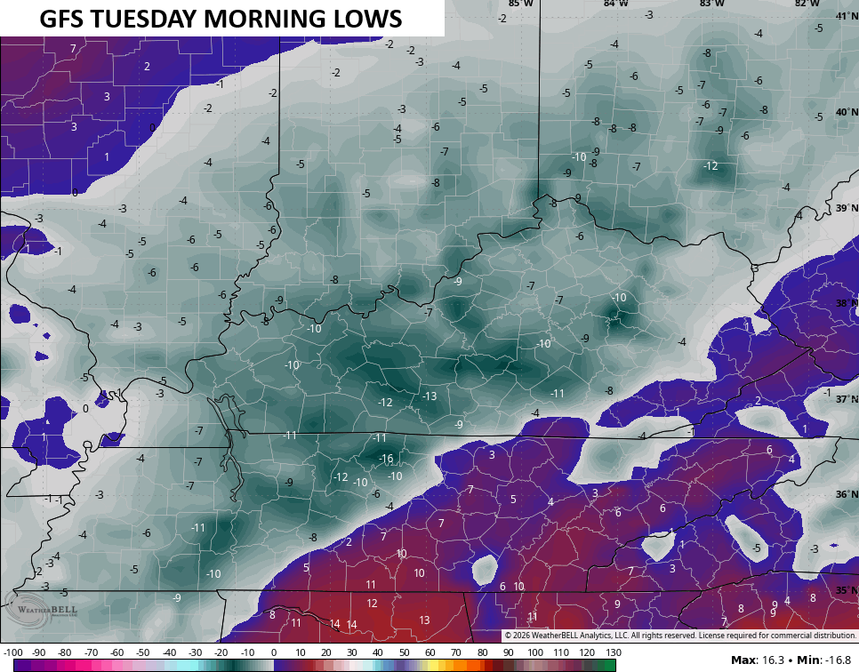
Temps likely stay in the single digits for highs on Monday with lows by Monday night and Tuesday morning potentially reaching -10 or lower in some areas…
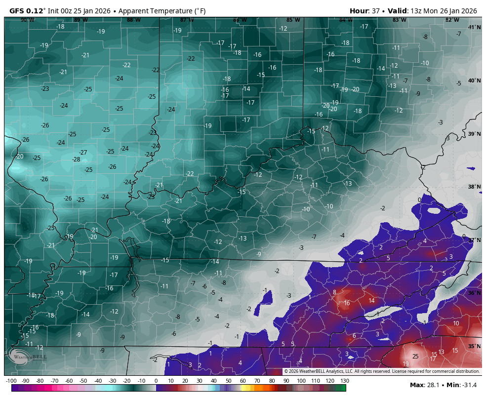
Wind chills may push -20 to -25 at times. This animation shows the wind chills from Monday morning through Tuesday morning…
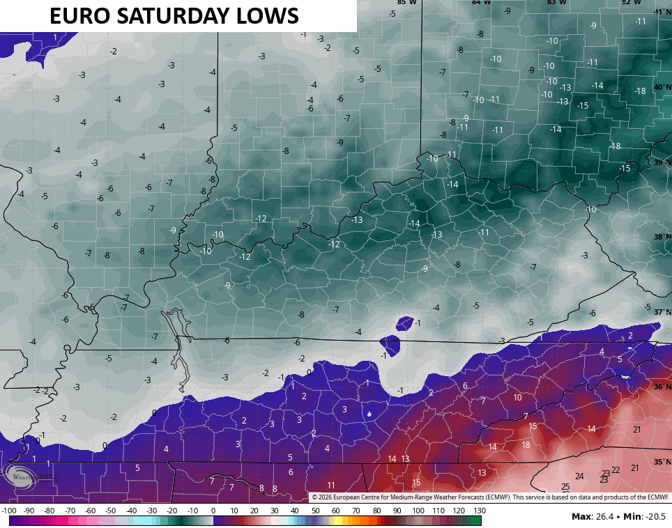
Lows can go below zero again Wednesday morning as a light snow maker drops in from the northwest. This is followed by another snow maker later in the week with another behind it as brutally cold air continues…
Low temps late in the week and next weekend may be even colder than what we have coming in over the next few days…
This is about as harsh of a week of winter weather as you will ever see around here.
I’m on WKYT-TV this afternoon and evening. I’ll also have updates on my Meteorologist Chris Bailey Facebook Page
Until then, here are your tracking tools for the day…


Make it a great Sunday and take care.

so then, why, if we’re getting an ice storm, have they not changed those areas to “ice storm warnings?” I guess they’re just leaving it as a winter storm warning? OK
Should’ve just predicted an ice storm instead of snow.
rough time folks!!!!!
Huge snow bust. Throw the modeling out the window and rely on historical data. Wow.
Thanks Chris. We Had About 3 Inches Of Snow And Ice, And Freezing Rain This Morning. It’s Beautiful To See The Snow, But Rare For This Part Of Kentucky. We Are Expecting Freezing Rain All Day, And Ending Sometime This Evening. A Power Outage Is Very Likely For My Area. I Would Predict, That We Will Be Without Electrical Power For Days, If Not Weeks. Not Many Live In This Rural Area Of Taylor County, So We Are Always Last To Get Our Service Back, And The Roads Treated and Cleared. Talking To My Older Sister And Brother In Law Yesterday Evening. They Live In South Florida. The Weather There Is Sunny With A Temperature Of 75 degrees ! I Can’t Afford To Live In Any Part Of Florida. LOL….
TAKE CARE EVERYONE,AND STAY SAFE AND WARM !!!
10000%00000% agree to all above. Models are only as good for amount of precipitation. Can’t predict strength of the warmth overriding the cold surface.
I believe NWS is out to lunch, they haven’t updated what’s going on since 4pm yesterday.
Also, The Models Didn’t Factor In That We Are Still Having Impacts From A La Nina Winter. It’s El Nino That Gives Kentucky The Increase Chance Of Training Snowstorms. Not So Much For Ice Storms. El Nino Has Been Missing In Action For A Number Of Years Now. Simply Put : La Nina Low Pressure In The North, And High Pressure In The South. Just The Opposite For El Nino.
Schroeder I completely agree, but my comment has nothing to do with that. It doesn’t matter La Niña – El Niño or any other combination of the two. The models can’t predict warm air advection in these big storms and the snow totals they were predicting up to the day of storm did not verify.
Understand Now, What You Were Saying. Thank You for The Clarification.
Latest From The Climate Impact Company : )
https://climateimpactcompany.com/u-s-early-notes-ice-and-snow-wind-down-in-texas-as-frigid-air-ma*s*s-arrives-ice-storm-shifts-to-mid-atlantic-heavy-snow-on-the-way-for-new-york-new-england-3/
Well we have had snow freezing rain sleet and now I believe it’s trying to go to just plain rain which I will take over ice. Looks like we all go back to snow tonight. I just hope we don’t lose power.
Schroeder so you got some snow I hope you don’t lose power either or none of us.
Thanks Chris for all your work on this storm.
Thanks Crystal. We Been Lucky So Far, For Not Loosing Power. Still Have Freezing Rain Though, And The Ice Is getting Heavy On The Tree Branches. A Matter Of Time. Hope You Receive Some Snow Later.
For Fun, I Looked Up The 2009 Ice Storm, Which Occurred On January 26. Here’s The Link : )
https://www.weather.gov/lmk/jan_2009_ice_and_snow#:~:text=A%20wintry%20mix%20moved%20into,as%20light%20freezing%20drizzle%20and
We got about 7-8 inches of snow here in Union.Co the sleet that we got with it cut down the snow total expectation. Neverless it did end the snow drought that we were enduring Snow is still falling may add on top what we got so far
Snow forecast still a bust.
Maybe in your area
Russell, Did You Receive Enough Snow To End The Snow Drought ? Here In Maple, We Didn’t. Snow Drought Back On Here In Maple.
I hate this storm!! It’s changed over to all rain and 35 degrees in southern Ohio!
Amazing how the snow forecasts not just locally but all throughout the path underperformed from
A snow forecast perspective.
Getting Ready For Round Two Of This Awful Ice. Barometer Currently Falling.
The Chicago Metro Area received between 2 and 4 inches of fluffy snow overnight into early this morning. The Lake Effect Snow Machine has turned on near Lake Michigan and the City of Chicago, enhancing the snowfall there considerably this afternoon. Here in the SW Suburbs, we received around 2 1/2 inches of snow.
It’s in the teens across the area, but temps will fall rapidly tonight to below zero, with wind chills in the -20 to -25 range.
Mike, Looks Now The Storm Is Moving Out. The Barometer Has Flat Lined, And The Dry Arctic Air Is Now Moving In. Glad The Storm Is Over. Really Glad We Didn’t Loose Power. I Really Think That I Would Have Had A Serious Health Issue Without Heat.
You Were Speaking Of Lake Effect Snows. Years and Years Ago I Had A Business As*sociate, That Lived In Saugatuck, Michigan, And In A week Or So, The Small Village Accumulated 8 Feet Of Snow Off The Lake. His House And Nursery Were Almost Buried. Shovelling Snow Off The Roof Of His House Was A Must. Snow Plow Trucks Were Coming Every 20 Minutes To Clear The Snows Off the Road In Front Of His Home. Snowfall Rate Was Probably 5 Inches An Hour. WOW !
Schroeder while we didn’t get what it looked like we mightve it did put a dent in it. Hopefully one more good one then I’ll be ready for spring. Maybe you and Maple will get another chance. Stay safe and warm.
I’m ready for spring now. 🙂
Jeff, To Balance this Long Cold Spell, There May Be Temperatures Well Above Normal This Coming Spring.
Thanks Russell. I’m Glad You Have Some Snow Cover, But I agree We Need Another Chance To Break The Snow Drought.
Just Found Out, That My Home Town In Indiana Received 17 ” Of Snow From This Storm. I Remember Those Major Snowstorms, But We Never Received The Ice That Kentucky Does. The 2004 Christmas Snow Was The Best. Up To 2 feet. The 2009 Ice Storm Stands Out As The Only Winter Storm Here In Kentucky That Impresses Me. Still Waiting On A Major Snowstorm Here In Maple. It May Or May not Ever Happen ?