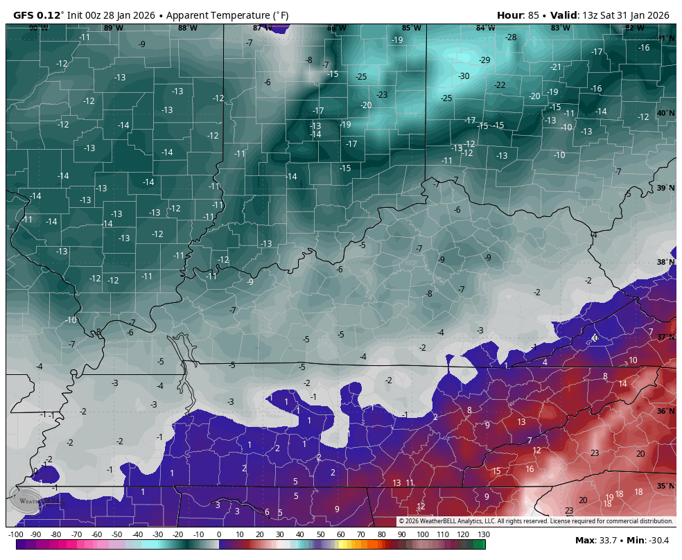
Good Wednesday to one and all. It’s a brutally cold pattern across the Commonwealth as we watch the next potential weather maker. That moves Friday into the weekend with the extent of the impact from this very much a work in progress.
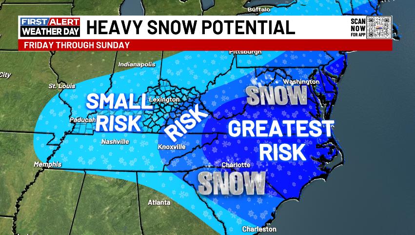
A big upper level system drops into our region Thursday night into Friday. That’s likely to really wrap up into a full-blown closed upper low as a monster surface low forms along the Carolina coast. This means the increased threat for a Mid-Atlantic snowstorm, but how far west can this go? The surface low can only come so far west, but the upper low closing off sooner would bring better snow chances into the east and southeast.
The greatest threat is to our east…
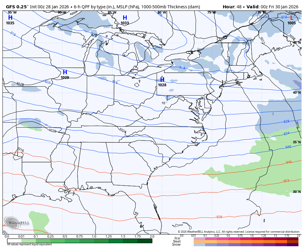
As far as the models go, we once again find the GFS in a different world than most models. This is the farthest west with the snow shield and would mean a lot of snow in the eastern part of the state. It’s really odd to see the GFS be west of every other model when the bias of the mode is to be too far south and east…
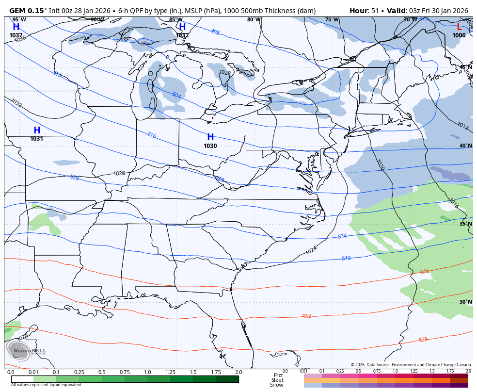
The Canadian is taking the place of the GFS and is the farthest east and most progressive…
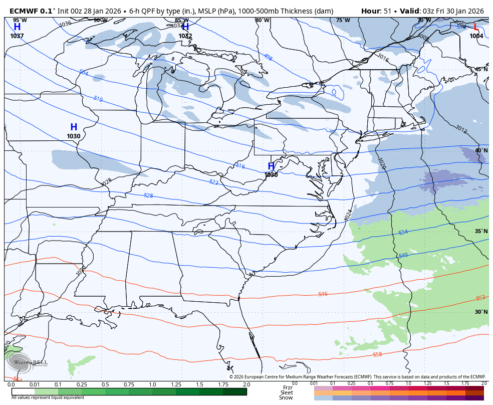
The EURO is a little farther west with the upper low, but continues to pound the southeastern part of the country with major snows…
Regardless of the snow potential, it’s another brutally cold blast coming in for the weekend. Here are the wind chills from Saturday morning through Sunday morning…
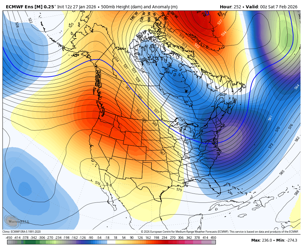
The pattern may ease up a bit into the first full week of February but looks to come roaring back by week two as another blocking episode shows up in the high latitudes. This shows up well on the Ensembles…
Updates come your way later today. I’ll also have updates on my Meteorologist Chris Bailey Facebook Page
Until then, here are your tracking tools for the day…


Make it a wonderful Wednesday and take care.

I’m not disappointed at all in this next storm hitting NC. They deserve it as they rarely get close to what we get here. I know, I lived there… It even snows more HERE than the part of western NC I lived in, much less central and eastern NC. Here, we get some snow every single winter. In western NC it would be 2, maybe 3 years with hardly an inch or two, then maybe year 4 a decent snow or two, then another 3-4 year snow drought until the next decent snow.
Mark, Sounds Like The Snow Schedule In My Part Of The State Of Kentucky.
If these hit they’re usually big hitters, more times than not they miss just South or East of I-75
Energy From Northwest ( Clippers ) Combine Or Phase With A Low Pressure System That’s Near The Atlantic, Leaving Our Area In The Cold And Dry Sector. With Nor’ Easter’s This Happens 9 Out Of 10 Times.
Kentucky will get much of nothing and this cold won’t last forever.
Of Course Not. Day Light Is Increasing, And In February It Warms Up, But Some Record Snowfalls Could Occur Anywhere In The State.
Thanks Chris. ” During The Past Week, The Arctic Oscillation Has Averaged A Negative 4.0, Very Supportive Of The Coldest Ending To January In The Eastern U. S. This Century. ”
https://climateimpactcompany.com/u-s-early-notes-the-caveat-forecasta-case-for-regenerating-cold-2/
The next thing you know the scientist will be saying were entering the ice age like they did back in the 60’s and 70’s
I Remember That Well, And Also There Were Days When The High Temperature Never Reached Zero degrees ! Plant Lost In The Nursery Was High. Two Of My Greenhouses Caved In On Account Of The Heavy Snows We Had. ” Climate Change ” Is Purely Political. A Way To Get Their Ridiculous Agenda Through, So They Can Control Our Lives. In My Opinion.
Hope we. can see some flakes down here in Hilton Head. I was back home in KY for the mid December snows and cold and would like to see at least one more flake or two this winter.
Here’s A Very Interesting Article That Says Europe Is Extremely Cold As We Are Here In The Eastern Part Of The CONUS. Usually It’s Not That Way. When We Are Cold Here, It’s Warmer In Europe. The Cause Is The Arctic Oscillation Is So Far Into The Negative. If The EPO And NAO Goes the Same Way, Some Places In The Eastern CONUS Could Have Some Major Snows To Come. Here’s The Link : )
https://climateimpactcompany.com/europe-week-2-4-outlook-ao-sustains-northern-europe-cold-and-energetic-southern-europe-storm-track-2-2/
And Australia is having record heat wave. Mother nature can do strange things
https://climateimpactcompany.com/ag-market-early-global-weather-climate-alert-southeast-australia-heat-eases-early-to-middle-next-week-and-then-returns-mjo-moisture-into-brazil-ongoing-europe-chill-2/