
Good Friday, everybody. It’s a gorgeous day across the Commonwealth as the sun brings pleasant temps along for the ride. This nice start to your Valentine’s Day/Presidents Day won’t last as a healthy rainmaker rolls in.
Highs out there today reach the 50s for most of the state with a mix of sun and clouds.
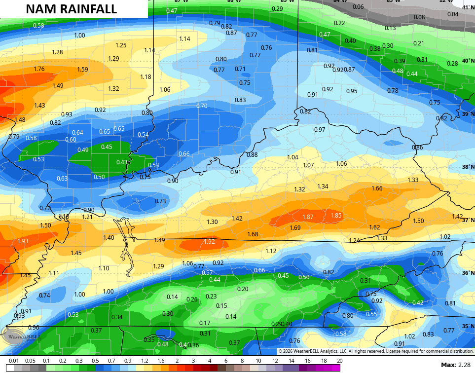
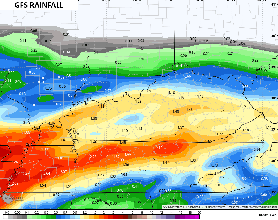
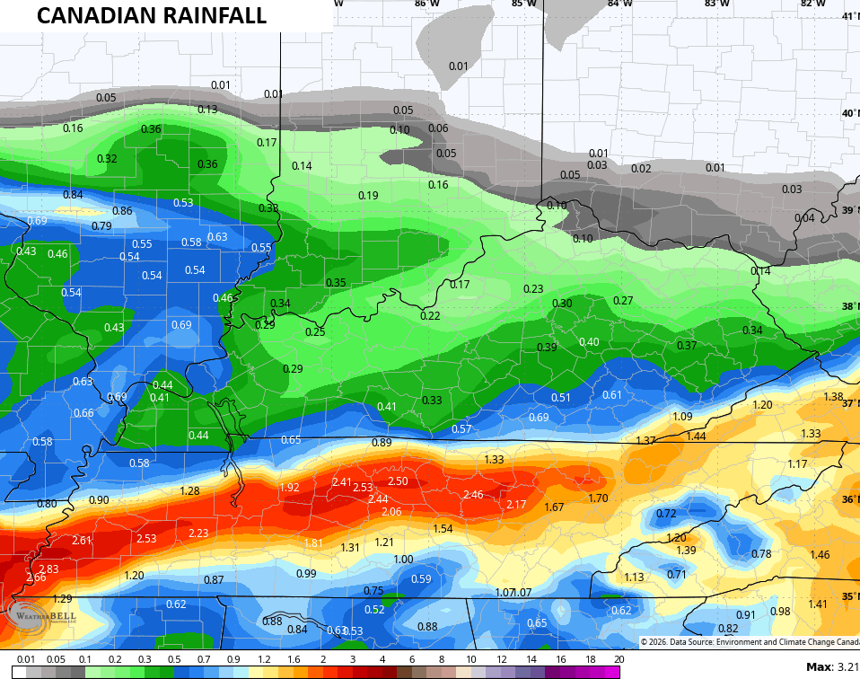
Low pressure develops in Texas today and rolls toward the Carolinas Saturday and Sunday. This track is to the south of us, but there’s no cold air available for any winter weather to the north of the track of the low. This means rain across our region.
This animation shows the west-east moving rains from Saturday morning through Sunday night…
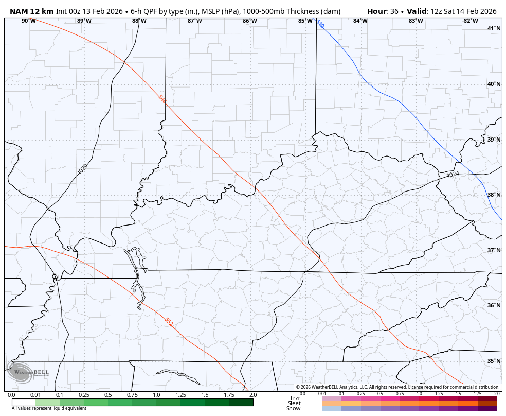
Locally heavy amounts show up with the best chance for an inch of rain or more being across the southern half of the state. The models still have some decent variance with where the heaviest rains show up…
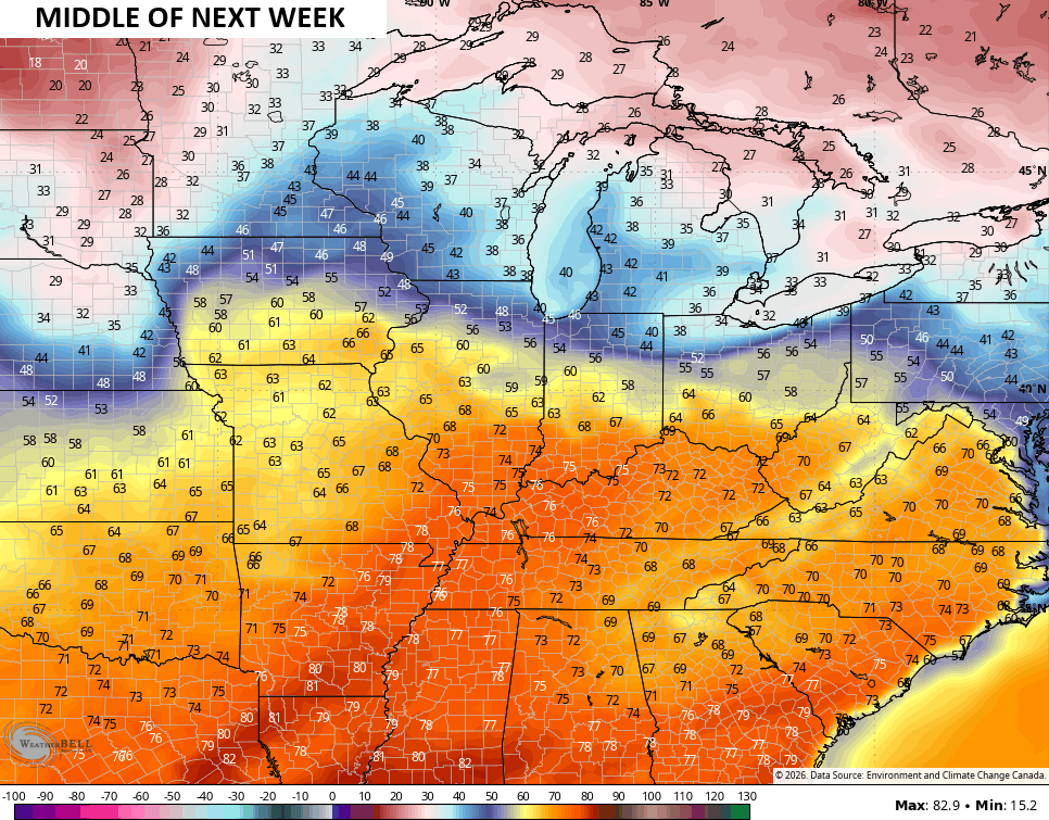
A major temp surge then shows up next week with the chance to hit 70 by the middle of the week…
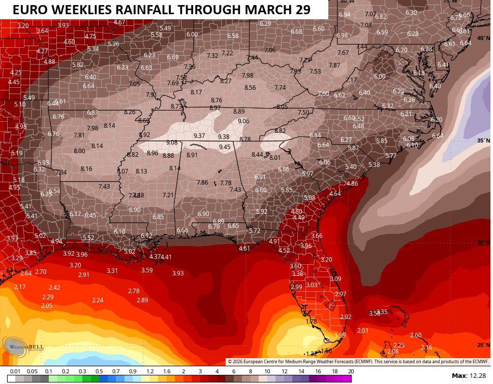
The EURO Weeklies continue to advertise a very active setup through March. Above normal rainfall is likely during this time…
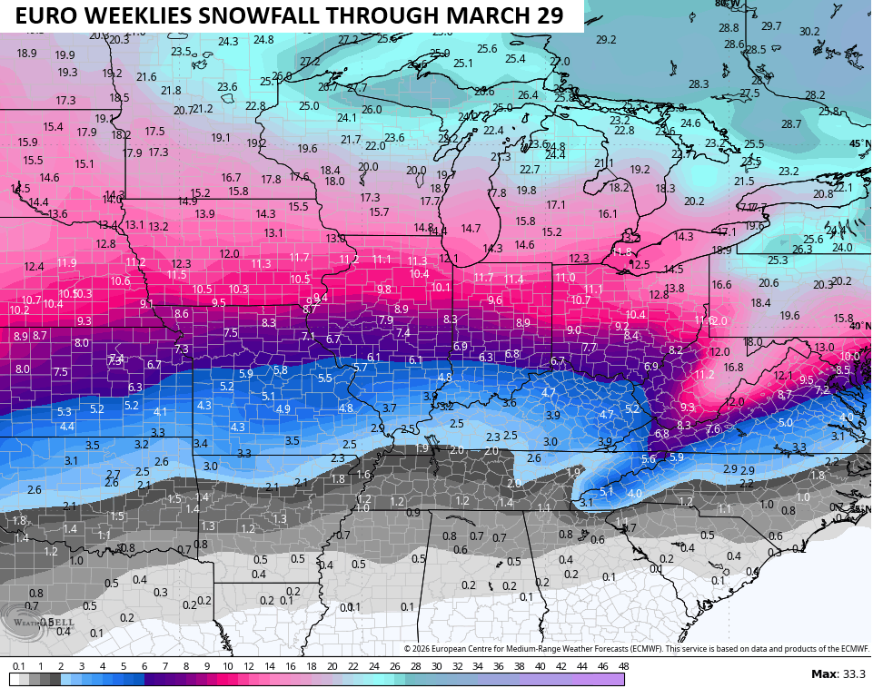
This active setup also means the increased likelihood of a significant March snowfall or two and the Weeklies have this possibility…
I’m on the road today, so this is the only update you will likely get. I will post some things on my Meteorologist Chris Bailey Facebook Page
Until then, here are your tracking tools for the day…


Make it a fantastic Friday and take care.

Im sure we will pay a price for next week warmrh
When The Colder, Arctic Air Does Return Later In The Month Into The Month Of March, That Would Be In The Time Frame For Heavy Snow Events to Occur. The Upper Layers Of The Atmosphere Are Much Colder Then Than It Was Earlier In December / January.
Adding To The Above : )
https://www.google.com/search?q=Is+Sudden+Stratospheric+Warming+Still+Occurring+On+The+North+Pole+Now+Or+Later+In+The+Winter+2026+%3F&sca_esv=109ab09de071e349&sxsrf=ANbL-n6DQttB_sPulu-L7l4Vasf-jKEclQ%3A1770990382511&source=hp&ei=LiuPacKKHZWxqtsP_tnmmAg&iflsig=AFdpzrgAAAAAaY85Pgi10Y3FbF0aKhAeLvrgsJb8mBNi&ved=0ahUKEwjC2ZelzdaSAxWVmGoFHf6sGYMQ4dUDCDI&oq=Is+Sudden+Stratospheric+Warming+Still+Occurring+On+The+North+Pole+Now+Or+Later+In+The+Winter+2026+%3F&gs_lp=Egdnd3Mtd2l6ImNJcyBTdWRkZW4gU3RyYXRvc3BoZXJpYyBXYXJtaW5nIFN0aWxsIE9jY3VycmluZyBPbiBUaGUgTm9ydGggUG9sZSBOb3cgT3IgTGF0ZXIgSW4gVGhlIFdpbnRlciAyMDI2ID9Ii_kIUOkcWOC-CHAKeACQAQCYAYoCoAHjPqoBBjYuNjAuMbgBDMgBAPgBAZgCSaAC3D2oAgrCAgcQIxgnGOoCwgIKEAAYAxjqAhiPAcICChAuGAMY6gIYjwHCAhAQLhgDGMcBGOoCGI8BGK8BwgIREC4YgAQYkQIY0QMYxwEYigXCAgsQABiABBiRAhiKBcICCxAAGIAEGLEDGIMBwgIFEC4YgATCAg4QLhiABBixAxjRAxjHAcICERAuGIAEGLEDGNEDGIMBGMcBwgIOEC4YgAQYsQMYgwEYigXCAgoQABiABBhDGIoFwgIKEC4YgAQYQxiKBcICEBAAGIAEGLEDGEMYgwEYigXCAggQABiABBixA8ICBRAAGIAEwgIOEAAYgAQYsQMYgwEYigXCAgYQABgWGB7CAgsQABiABBiGAxiKBcICBRAAGO8FwgIIEAAYgAQYogTCAgUQIRigAcICBxAhGKABGArCAgUQIRifBcICBRAhGKsCmAMI8QV20n44UaBMlZIHBzE0LjU4LjGgB-2OA7IHBjQuNTguMbgHqj3CBwcwLjYwLjEzyAetAYAIAA&sclient=gws-wiz
Wow, thanks for this info Shroeder! This is fascinsting! It has been a harsh winter for sure–definitely one of the coldest for the most extended period of time that I can remember.
Though the CPC now says there is a 60% chance for La Niña to ENSO-Neutral transition during Feb thru Apr, it appears that this transition has already begun. East to west trade wind velocities have weakened, and the sea surface temperature anomaly chart shows that warming in the eastern equatorial Pacific is well underway. Historically, when this transition occurs in the late winter to early spring timeframe, we see an uptick in severe weather, especially during the mid March to mid May timeframe.
https://www.ospo.noaa.gov/products/ocean/sst/anomaly/
I think we’re going to see a lot of severe weather into spring & early summer for sure, Joe.
It Will Be Interesting To See After The ENSO / Neutral Event Occurs This Spring, If We Slowly Phase To ENSO / El Nino, But If The ( PDO ) Now Presently In The Negative Phase Doesn’t Phase To The Positive, El Nino Will Not Have Much Of An Impact On Next 2026 – 27 Fall And Winter. Weak El Nino’s Bring Colder, Snowier Winters, If The ( PDO ) Is Positive. Remember 2014 – 15 Winter Here In Kentucky ? Not Many On Here Remember The Winter 1969 -70. A Weak El Nino Winter / Positive ( PDO. ) Winter Started On December 21st With A Snowstorm, And There After One Snowstorm After Another Through Mid – March 1970. This Occurred In South / Central Indiana.
NOAA Announcing New ENSO Index : )
https://climateimpactcompany.com/u-s-early-notes-support-to-keep-u-s-pattern-warm-increasing-news-on-new-nino34-ssta-index-and-aifs-updates-2/