Good evening, everyone. Rounds of severe storms continue to target the region through the wee hours of the morning, then our attention turns to Old Man Winter. There’s a legit chance to put some snow on the ground late this weekend for some areas.
A few more severe storms will rumble across the region late this evening into the wee hours of Friday morning, especially across the northern half of the state.
Here’s the current Severe Weather Outlook from the Storm Prediction Center…

Damaging winds, large hail and isolated tornadoes are once again possible.
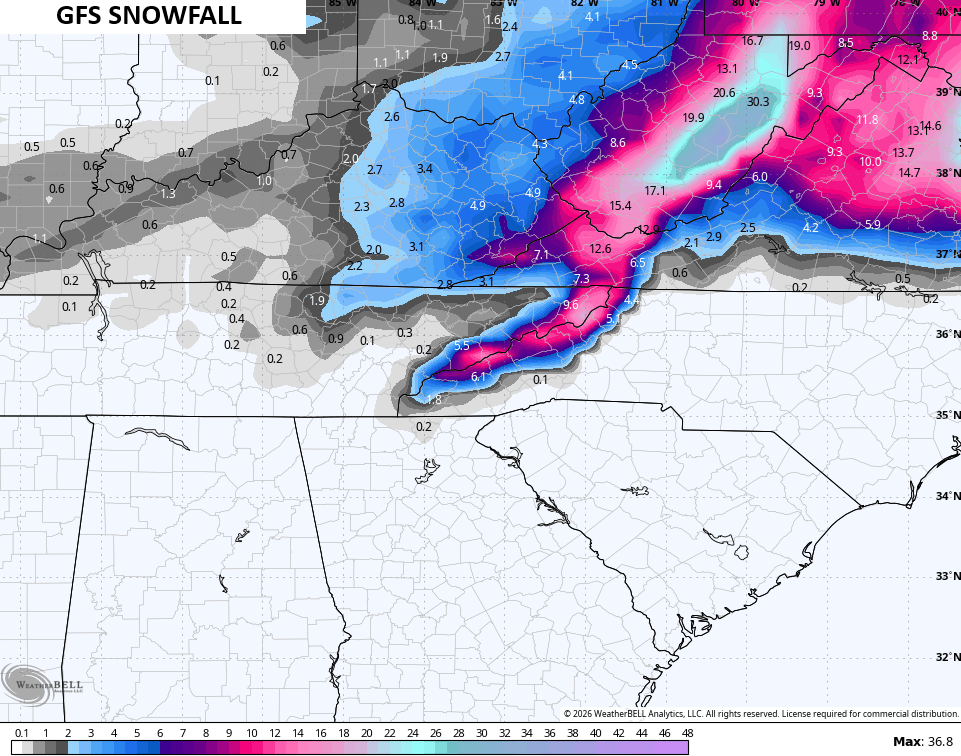
Calm skies show up for Friday with partly sunny skies and gusty winds. This is ahead of winter surging back in here over the weekend and into early next week. The GFS is trying to show a full-blown snowfall across central and eastern Kentucky from that low pressure to our southeast. Then, snow showers and flurries kick in on a strong northwest wind flow…
Snow lovers have got to be cheering on the GFS with this look…
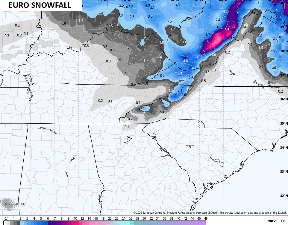
The EURO isn’t nearly as robust, BUT… it trended a bit toward that look…
Even that shows some light accumulations…
Temps come way down and may not get above Freezing for Sunday and Monday. Winc chills may drop into the high single digits for some. This animation runs from 7am Sunday to 7am Monday…
The main update comes your way later tonight. Until then, here are all the storm tracking tools you need to start the week…


Current watches

Possible Watch Areas

Make it a great day and take care.

Thanks Chris. I Will Be Relieved When The Severe Weather threat is Over. Severe Weather, Anymore Makes Me Nervous. Hoping The GFS Snowfall Is Correct, But My Area Is A Bit Too Far West This Time Around.
I don’t know about any of you but I just got what I think is the largest power bill EVER… $350 (we have no gas) it’s all electric. I knew it was going to be bad so I’m not surprised. And they’re raising the rates too… YAY!
I was surprised at having a $211 bill at the end of December. Then the next one was $262. Thankfully we got a load of wood and I’ve got my fingers crossed that our next bill won’t be as hard to stomach. Oh, and KU/LGE got another rate increase?! What’s going to happen when they start building all of these data centers that raise our rates even more?
Dottie, It’s Going To Be Very Expensive To Heat And Cool Your Home. When I Moved Here In 2008, My Electric Bill For Heating Was Around $ 120.00. My Heating Bill In 2026 Was $ 265.00.
Mark, My Electric Bill And Water Bill Was the highest I Ever Payed, And My Cabin Is Well Insulated. The Companies Have Increase The Rates. It’s Getting Expensive To Live Here. I Have The Phone And Internet Bill Yet To Come. I Bet That Will Have The Increase Too. UGH !