Good Monday to one and all. A potent storm system is on the way for the middle of the week, bringing the increasing threat for severe weather in our region. This severe potential is along and ahead of a massive drop in temps that can bring a flake or two into the region just a few hours after the storms stop.
Let us begin with today and roll forward. Highs are back into the upper 60s and low 70s with a mix of sun and clouds. The chance for a shower or storm is there with the greatest opportunity across the southern half of the state.
A few more storms increase as a strong southwest flow kicks in on Tuesday. This is ahead of a huge storm developing in the Plains states. This storm will head toward the northern Ohio Valley and Great Lakes Wednesday into early Thursday. This looks to spawn a significant severe weather outbreak from the Plains into the Ohio Valley.
The initial threat on Tuesday is greatest well to our west with the low-end risk across the western half of the state. Here’s Tuesday’s Severe Weather Outlook from the Storm Prediction Center…

The individual threats for Tuesday show just how prolific of an outbreak is possible to our west on this particular day…


The threat for severe storms then focuses eastward into our region Wednesday and Wednesday evening. Damaging winds, large hail and a few tornadoes are possible across Kentucky and surrounding states.
The Storm Prediction Center continues to highlight the increased severe weather risk with Wednesday’s Severe Weather Outlook…

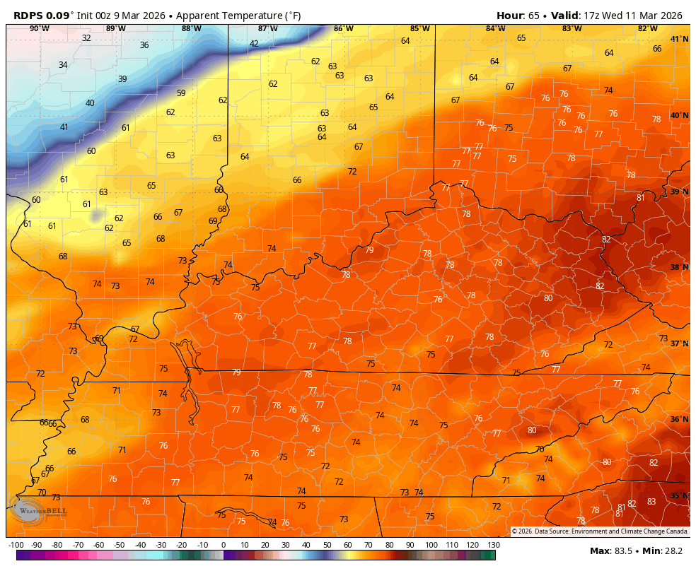
Temps on Wednesday surge to near 80 degrees across parts of central and eastern Kentucky before tanking behind the cold front sweeping through Wednesday night. Wind chills reach the mid and upper 20s by Thursday morning with the chance for a few snowflakes.
Check out this animation that goes from 1pm Wednesday to 8am Thursday…
Goodness, that’s one big drop!
Temps jump back up on Friday into the weekend and may flirt with 70 again. This is, unfortunately, ahead of another system set to bring our temps WAY down. It’s a pattern that may also deliver some light snow chances next week…
It’s a true fight between spring and winter and the battle zone is right on top of our region.
Another update comes your way later today. Until then, here are all the storm tracking tools you need to start the week…


Current watches

Possible Watch Areas

Make it a magnificent Monday and take care.

Normal March stuff. No big deal.
The Chicago Metro Area is in the bullseye for an Enhanced Risk of severe weather on Tuesday afternoon/night. There’s going to be a front bisecting the area later tomorrow, with the greatest threat for tornadoes south of the front. The major threat for large hail for the entire Chicago area is particularly concerning.