Good Saturday to one and all. All signs continue to point toward historic heat for Sunday as temps surge toward summertime readings. Sunday will be one of the warmest March Days on record for Kentucky before a cold front brings strong storms and knocks the numbers down.
Speaking of storms, there’s the chance for a storm or two in the south early today before partly sunny and windy weather takes control. Highs today range from the mid and upper 70s east to the low and middle 80s in the west.
Sunday’s highs surge deep into the 80s with the possibility for a 90 degree high temperature in the west. You heard that right… A 90 is possible if we can get enough sun. Daily records for March 22nd will be taken out with the chance some cities to approach all-time warmest March readings. Wow!
I first pointed out the possibility of this more than a week ago when I started to see the extent of the heat building in the Plains and here we are.
A cold front brings some showers and storms rumbling through here Sunday evening into Sunday night…
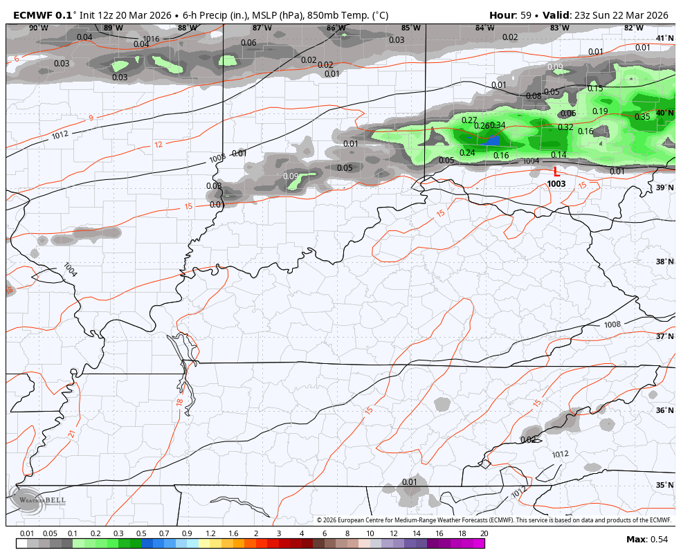
There’s the chance for a few strong to severe storms and the Storm Prediction Center is highlighting the possibility…

Large hail and damaging winds will be the primary threats. Here’s a look at the individual severe threats from the Storm Prediction Center…


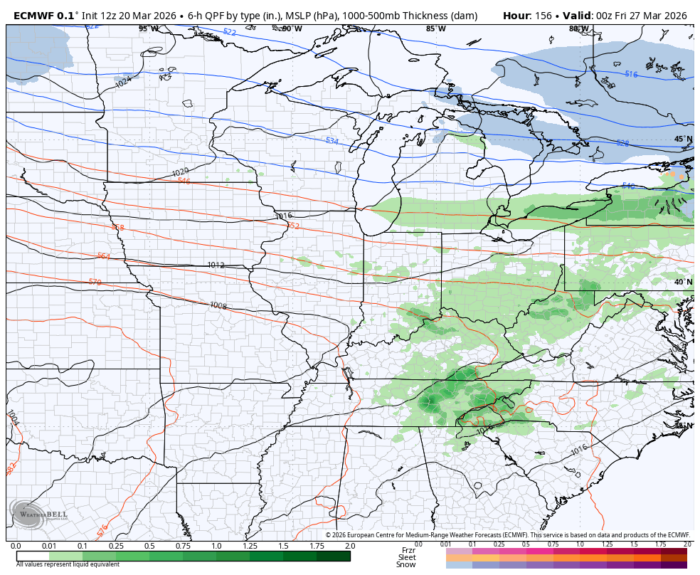
Temps come down to more typical levels for Monday with highs in the mid 50s to low 60s. Windy weather hangs tough into the middle of next week as temps spike again to around 80 on Thursday. That’s ahead of another strong storm maker as another cold front drops in.
The pattern turns colder behind that before another bounce back. Temps should jump right back up with the potential for some stormy times lurking to end the Month and begin April…
I’ll drop by for another update later today. Until then, I have you all set to track whatever storm action goes up today…


Current watches

Possible Watch Areas

Make it a sensational Saturday and take care.

Thanks Chris. Will Enjoy The Warm Summer Like Weather, But This Year Of Extremes Continues. Out West, Really Has Me Concerned. An Abnormally Strong High Pressure Ridge, Influencing A Large Area Of Real Estate Of The CONUS. This Could Be A Potential Diaster For The Agricultural Industry In The Way Of Crop Production If It Decides To Propagate To The Corn Belt. A Drought Would Happen At The Worse Time. I Expect That The Drought Will Engulf Kentucky And surrounding States This Summer. May Be Like The Awful Heat And Drought Of 1988. We Shall See.
This Is Happening Because Of Very Warm Sea Surface Temperatures In The West Pacific, And Colder Than Normal Sea Surface Temperatures Along The West Coast. Been Going On Since 2019. A Record Negative Pacific Decadal Oscillation ( PDO ) Will Prevent The Forecasted Very Strong El Nino From Reacting With The Atmosphere. Therefore, A La Nina Like Weather Pattern Will Continue. Lets All Hope The Above Negativity Doesn’t Happen. One More Thing, I Notice That The Cold Fronts Have Shifted More To Our East And Northeast. That Dome Of Strong High Pressure Is Beginning To Propagate Into our Area Of The CONUS.
Chris And Everyone Please Read This Climate Article : )
https://www.pbs.org/newshour/science/scientists-say-another-hot-year-is-a-warning-shot-of-a-shifting-dangerous-climate#:~:text=Several%20of%20the%20climate%20monitoring,about%20as%20hot%20as%202025.
This weekend will be the shape of things to come, especially in the western states, where a heat dome is becoming established quite early in the season. I’m afraid that the summer temperatures in the west will not be the only thing on fire, and that danger will extend from California all the way to Alaska, and eastward to Colorado. We will share in that above normal heat, not to the extent that the west will, and precipitation average out at slightly below normal levels. I have to differ with Schroeder regarding ENSO, as I believe the chances for a super El Nino are growing, and though it will make for a weak the Atlantic hurricane season, the Gulf of Mexico and western Caribbean could produce significant tropical activity, as surface water temperatures soar. We have currently phased into ENSO-Neutral but it will have a short stay, as I see El Nino conditions beginning as early as late July, as the west to east trade winds velocities are already increasing. The PDO will indeed stay negative, but it will have little effect on El Nino conditions, as continued atmospheric warming has reduced the relevance of this indicator.
Joe, In 2023 -24 A Strong El Nino Occured, Operating In A Negative PDO, Had La Nina Like Weather Patterns. How Can That Be Explained ? Here’s A List Of Past El Nino And La Nina Years And Their Intensities : )
https://ggweather.com/enso/oni.htm
Adding To The Above, The 2015 – 16 Winter, Was An El Nino Year, With A Positive PDO. The Temperatures Average Above Normal With Above Normal Snowfall : )
https://www.google.com/search?q=winter+2015+-+16+in+kentucky&sca_esv=a6353af7fb849714&sxsrf=ANbL-n50GFAini_Y6a7CcAXo3ILAHc0a7w%3A1774106960369&source=hp&ei=ULm-aemWFO-Ip84P086mkQY&iflsig=AFdpzrgAAAAAab7HYOAcuRHmDo4kVhDSo3kqZe05AxSf&oq=Winter+2015+-+16+In+Kentucky&gs_lp=Egdnd3Mtd2l6IhxXaW50ZXIgMjAxNSAtIDE2IEluIEtlbnR1Y2t5KgIIADIFECEYqwJIsa8CUABY34kCcAB4AJABAJgBgwGgAcsZqgEEMS4yN7gBAcgBAPgBAZgCHKACqxvCAgoQABiABBhDGIoFwgIQEAAYgAQYsQMYQxiDARiKBcICCxAAGIAEGJECGIoFwgINEAAYgAQYsQMYQxiKBcICERAuGIAEGLEDGNEDGIMBGMcBwgIOEAAYgAQYsQMYgwEYigXCAgoQLhiABBhDGIoFwgIKEAAYgAQYFBiHAsICDhAuGIAEGLEDGNEDGMcBwgIIEC4YgAQYsQPCAg0QABiABBixAxgUGIcCwgIFEAAYgATCAggQABiABBixA8ICBRAuGIAEwgIGEAAYFhgewgIFEAAY7wXCAgsQABiABBiGAxiKBZgDAJIHBDAuMjigB5eIAbIHBDAuMji4B6sbwgcIMC44LjE4LjLIB5QBgAgA&sclient=gws-wiz