Good Thursday, folks. Our super-soaker of a weather pattern is underway with rounds of rain and thunderstorms impacting the region. This setup will likely include some local high water issues from time to time through the Memorial Day holiday weekend and into next week.
Rain is common today across areas of central and eastern Kentucky with the heaviest falling across the southeast. Skies will dry across the west and north but our temps are going to be VERY cool for this time of year. Afternoon temps in the 60s will be noted with the chance for few areas to struggle to get out of the upper 50s. What the what?!!
The slowed boundary has another low pressure develop along it later tonight and Friday. This low rolls northward, bringing more showers and storms across Kentucky. This future radar shows the action from late tonight into early Saturday…
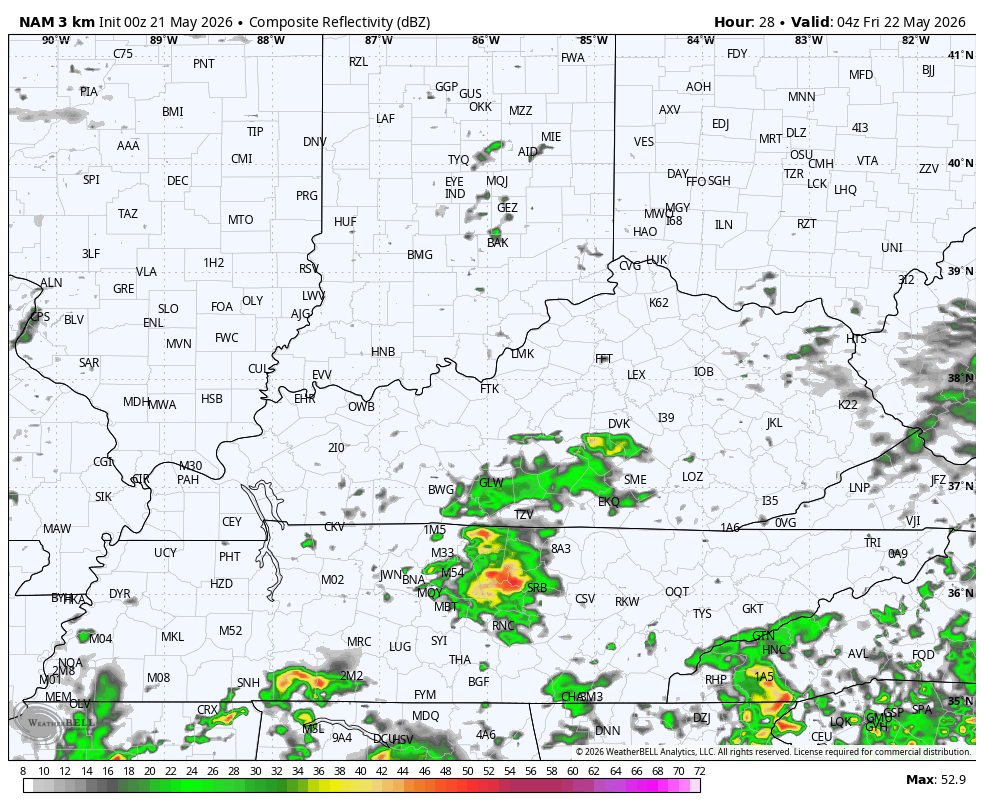
A few strong storms can’t be ruled out and we will need to be on guard for local flash flooding.
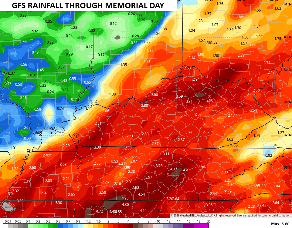
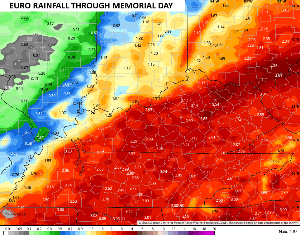
Even more rounds of showers and storms rumble through for Sunday and Memorial Day, once again bringing heavy rainfall from time to time. Forecast models don’t really handle rainfall from thunderstorms very well, but the fact they are still showing several inches of rain now through Memorial Day is impressive…
Additional rounds of showers and some storms will show up next week into the following weekend. The EURO AI is showing a lot of rain over the next 2 weeks from our region and south…
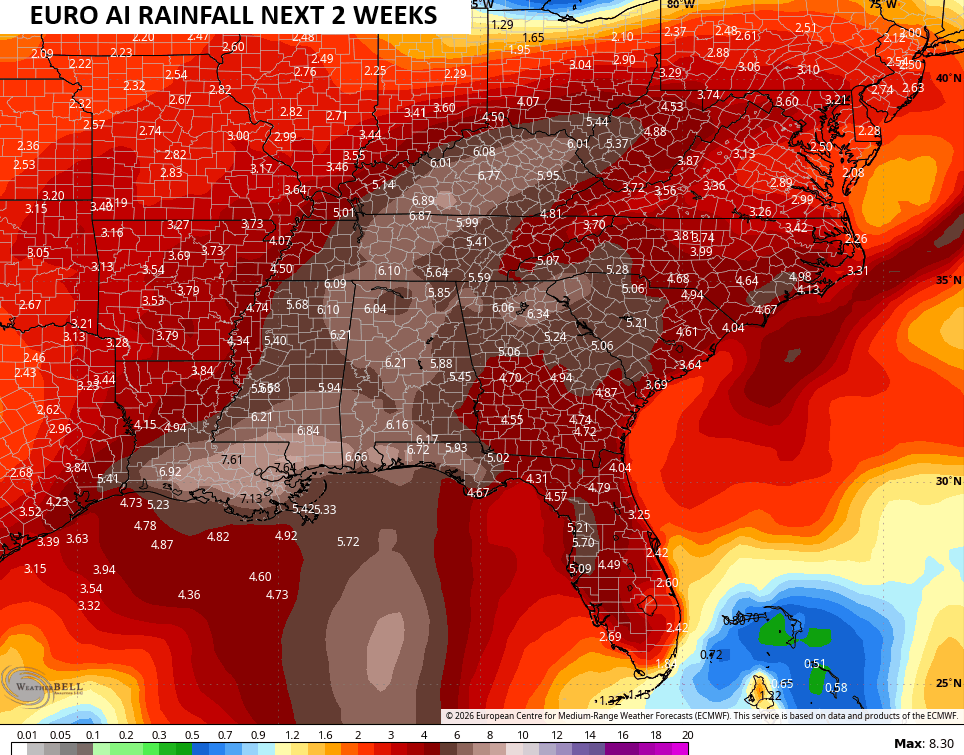
The EURO Weeklies sniffed this wet pattern out a while back and they continue to show a wet setup into the first part of Summer. Take a look at the average rainfall numbers from the 101 members of the EURO Weeklies…
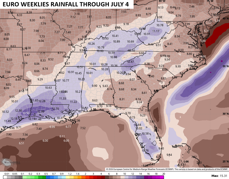
Those numbers are well above normal…
I’ll have the latest on WKYT-TV and on WKYT + later today. Until then, here are the tracking tools you need for the day…


Current watches

Possible Watch Areas

Make it a great Thursday and take care.

Thanks Chris. The weather outlook for the Summer months came out yesterday from the Climate Impact Company. June / July / August, calls for normal temperatures and above normal precipitation for our area of the Country.
Here’s the very well explained article link : )
https://climateimpactcompany.com/u-s-month-1-4-ahead-climate-outlook-summer-2026-features-anomalous-heat-in-the-northwest-and-gulf-states-and-occasionally-adds-the-great-plains-due-to-developing-dry-conditions-ohio-valley-to-nor-2-2/
Early this morning I had over 0.60 ” in my rain gauge. Very much needed !
The long range models have been hit or miss lately.
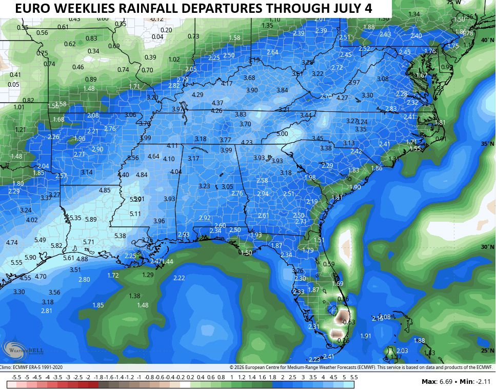
On Wednesday, my PWS recorded exactly 1 inch of rainfall, which helped but there’s still a long way to go,. Warren County is currently 10.1 inches below normal, which is concerning since May is normally the wettest month of the year. The county continues to be labeled Extreme Drought, and this is reflected in some of the area’s lakes and rivers. Barren River Lake is 10.3 feet below full pool, and Rough River Lake is over 18 feet below normal. I agree that the pattern is finally trending wetter, but the amounts forecasted by the Euro Weeklies are totally ridiculous.
A significant majority of climate forecasters are in agreement that we are in the initial stages of a Super El Nino, and it is forecasted to peak in January. One thing to keep in mind: the last Super El Nino took place in 2015 and also peaked in January of 2016, and one of the largest snowfall in recent years occurred on January 22nd and 23rd of 2016. It’s likely that 2016 will be one of Chris’s analog years come fall!
Joe, That would only occur if the PDO becomes positive with the predicted El Nino event.
According to the Kentucky Mesonet we received 0.92 ” here in Taylor County. A good start to diminishing this terrible Spring drought.
Heaviest and deepest Snowstorms All occurred In El Nino events operating in a positive PDO. Years I can remember : March 1960, 1969 – 70 Winter, and the most recent, late December 2004 where 2 feet of snow fell in three days. A beautiful White Christmas occurred that year in Vanderburgh, County Indiana. Here in Kentucky 2015 we received over 15 inches of Snow.
A growing number of climatologists are saying the the influence of the PDO on El Nino formation and strengthening has become less importantin recent years, primarily because atmospheric warming is distorting its values when compared to historic data. The current thinking is that the ENSO mechanism itself has taken over as the prime influencer on the strength of an El Nino, along with variations in, or a downright directional shift, in the trade winds. The way I see it, the 2026 instance shares a great deal of similarity to 2015’s Super El Nino, but atmospheric warming is the wild card that could push this year’s into uncharted territory.
Thanks Joe. I stand corrected. Climate Change to the warmer is occurring. We need a new way to forecast the weather.
True, because Artificial Intelligence ( AI ) is being incorporated into long ranged weather models. Bad move in my opinion.