Good Friday, folks. Your friendly weather dude is a happy, but tired man after the wicked weather of Thursday. The happy part comes because things worked out well with the forecast. The tired comes from the hours I put in during nasty events. There’s no rest for the weary… it gets a whole lot worse as we head into late this weekend and through next week.
Let’s begin with today and roll forward.
Temps to start will be in the single digits and low teens for many areas. Gusty winds will create wind chills of -5 to -10 at times. Leftover flurries and snow showers may be noted across eastern Kentucky. The power of a true upslope flow is often overlooked.
After a windy and chilly Saturday… it’s full steam ahead toward a system rolling in for Sunday. This will be a snow maker… but how much is the question. No matter how much falls where you live… the headline continues to be the life-threatening cold that comes behind it.
A arctic front will be located on top of the state Saturday night and early Sunday. A wave of low pressure will develop along this front and roll northeastward across the region. A band of heavy snow will develop along and west of the track of this system. Here’s where the GFS tracks the low…
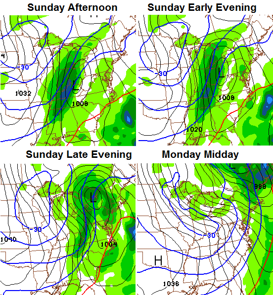
This not going to be a deep area of low pressure and these waves often end up flatter than forecast because the models tend to underplay the eastward push of arctic air behind them. Models like the Canadian and European had a stronger system a few days ago, but are now coming in flatter with the wave.
How far east that front is as the wave works along it will determine how much snow can fall where you live. I suspect we won’t get a complete picture of that until tonight. Several inches will be likely to the left of the track of the low.
Regardless… this type of a setup is prime to produce a line of snow directly behind the arctic front. I have seen similar situations produce what amounts to a squall line of snow and whiteout conditions for a time. Will this one do the same as it rolls across the state? That’s a possibility.
Temps behind this front are going to drop off the charts in a hurry. A 20 to 30 degree temperature drop in an hour or two is likely. Winds will go wild and temps by Monday morning will likely drop below 0 for many. Temps during the day may not move much at all and some could stay below 0 right on through Tuesday morning. I wonder if this can even squeeze out arctic snowflakes during this time?
Gusty winds are going to combine with those temps to give us something we haven’t seen in MANY years. Extreme wind chill readings. Look at the numbers from the GFS…

This is a potentially life-threatening situation taking shape. You should respect the cold potential and take any necessary precautions in advance.
The bitter cold lifts out on Wednesday and is likely to be replaced by a snow or ice system by Wednesday night and Thursday…
I will have updates later today. Stay safe if you’re traveling and take care.

Thanks Chris we finally got in on some snow and wind.Thanks for all you do a little clip of the snow.
http://www.youtube.com/watch?v=6t-OuXxPb7E
Not that I want it to get that cold, but if the temps are dangerously low, I surely hope at my work they will tell us not to come in. My commute is over an hour and there’s no reason to be risking my life for that place. They don’t care though. All they care about is the dollar but maybe I’ll get lucky and they will tell us not to come in.
It’s a wind chill predection from about 5 days out……Wind Chill, which is just a meteorological way of making something sound way more extreme than it actually is.
BigPoppaSnow
Hope everyone stays safe and warm during the upcoming brutal weather temps. IF you must travel prepare an emergency survival kit for your car. Blankets, extra warm clothing, gloves, hats, scarves, water, flashlight with batteries, well charged cell phone and booster cables are essentials for a car kit. Have a great Friday everyone.. Keep warm. God Bless
Best post you have ever written on here Thanks
I’m nice like that 🙂
Thank you for the good reminder!
Welcome
Amen! Please, please make sure your pets and all outdoor animals have a place to get out of the weather. Also, check on your elderly neighbors or anyone you think might be at risk. Taking situations like the upcoming bitter cold seriously and preparing in advance prevents tragedies. Be safe.
Sorry you are worn out WeatherGenius! Thanks for all you do to keep us informed and prepared! Be sure to find some time to enjoy this snow…may be too cold to play in but you can sure get some coffee or cocoa, cuddle up in a blanket, and appreciate the beauty of it.
Thanks again for all your hard work on our behalf!
I do not recall a time having these cold temps without significant snow in front of it. Bummer, but what can you do? Stay warm seems an obvious answer.
Oh, those are wind chill temps. That makes more sense, so we still need significant snow to get the crazy cold temps from 93 or even 96. That said, 0 or -10 are kind of same bed fellows with wind.
You really only need a couple inches for radiational cooling. Like this morning. Wasn’t expecting low single digits to start today.
Who says we won’t get a significant snow from this? Possibility’s are very much there for a significant dusting to a inch maybe two. 😉
I was thinking a few inches more than that 😉
Just goes along with the trend we have been stuck in I guess Bubba. Maybe it will overachieve and the entire area can sqeeze out 4″ or more.
Temp bottomed out at 5° this morning here in Lexington on my thermometer, just what I expected since last night because everything, even roads are still completely snow covered with about an inch of fluff.
1 Above air temp in Lawrenceburg right now. Amazing what just a little snow cover can do to the temps!
Its 13 at my house the coldest day so far but not by much. I’m glad there is no wind at there to be had atm may have ended up with 1 inch of light powdery snow.
14 and around half inch snow in Carrie of knott co
Nice job predicting this one, Chris! You nailed the forecast for Pikeville. 14 and a couple of inches.
I think this is too funny……Yesterday, my electric blanket died. Irnoic
ironic, not irnoic.
That is the brand name of the blanket. It’s Norwegian 🙂
Swedish. The Swedish chef is their spokeschef. “Bur, today ve go to bed vith the Irnoic electric blanket. Bork bork bork!”
Wow, 18 flubbed yesterday and now they have cold temps for Monday Tuesday that are ten degrees warmer expected. That is what they showed this morning at any rate.
Not picking on them, but intrigued by the differences.
me either …. I literally watched it change 3 times for next week …. Thu it started out saying 50, then up to 57, then down to 42 …. untelling what it will actually be until it gets here … it is like Forest Gump and his box of chocolates !!!
I say pick on them to no end. Bill Meck is goofy.
I think the correct term is “painfully white”. 😉
absolutely love when road crews scrape the only thing you can get traction on and don’t salt.
I noticed that too.
Not to be a negative Ned, but we still have not had any threat mode. Cold air without at least a shin kicker is just a bunch of air of the cold variety. Really cold.
To rub the road salt in our cold wounds, we might get ice later in the week.
You all just need more cheese.
http://www.nytimes.com/2013/12/24/us/wisconsin-finds-another-role-for-cheese-de-icing-roads.html?_r=0
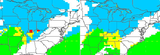
Day 3 outlook. Of course, this could change as it has in the past.
http://www.hpc.ncep.noaa.gov/wwd/day3_psnow_gt_04.gif
Thanks CB for the update. As for nailing the forecast, EVERYONE (including the NWS) busted on the Lou. area. Did not see flakes until at least 10am. Everyone including CB said Snow early morning thru noon with snow showers afternoon. We had our worst conditions on my side of Lou. between 4 and 8. Gave us a deck dusting. I blame the heat island effect for Lou. we are always a couple degrees warmer due to the city. When it is 32 in all boarding counties it will be 34-36 in Jefferson.
That’s really not true when it’s 34 or 35 degrees in Louisville that official temp is not accurate the official temp in Louisville is taken at the airport. While the airport sits warmer due to the asphalt jets coming and going it’s always warmer at the airport. If it’s 34 at the airport most of Jefferson County will sit 2 to 3 degrees cooler outside of the airport and downtown and some locations even cooler than that. The official temp should be taken at the NWS office in Louisville not the airport way to bias when it comes to a real accurate temp.
My kids are begging to go outside and play in this snow. Isn’t it too dangerously cold? Maybe I will let them out and they won’t stay long until they are begging to come back in.
As for the next Snow chance IBIWISI…..I know that makes some of you mad, but that is the way Kentucky snows go. Really like the looks of the GFS above as it has the highest precip. totals going straight up throught the middle of the state. Not where you want to be three days out. This low will waffle a bit. Ending up to the North and West (as always) with (dare I say it) cold rain for most and very cold temps on the back side. As someone commented yesterday anything below 15 degrees is cold. Not trying to be a debbie downer but (dare I say it) Trends of Ky snows do not favor the Sunday/Monday event. IBIWISI……………….THINK SNOW!!!
really nice work on the forecast, Chris!
5 degrees in town Lexington this 5:30 AM
4 degrees out in county
maybe 1 1/4″ snow looked like 2+” at the office and in county
hope this Sundays snow hits a good one
About an inch in Lawrenceburg from yesterday’s snow.
Here is hoping that Sunday can prove some of these haters WRONG!
Only in south central Kentucky can it be in the single digits warm up and rain and be below zero in under 48 hours.
One other thing, while I’m on a rant this morning, all of these forecasts about “extreme” weather are way overblown. Extremes make averages, so in essence, nearly any weather event is an extreme of some sort, wet then dry = normal precipitation, cold then warm = normal temperatures, windy then calm = average winds, wild forecast then boring forecast = average forecast.
Stay calm & average, my friends.
BigPoppaSnow
I agree in principle that the word “extreme” is way over-used these days, but I’ve lived in this area for almost 40 years, and if something below -10 with wind chills approaching -30 happens, I would have to call that extreme for us here.
Chris nailed this one pretty much perfectly for my area in both precip amount and temp, as well as the timing. I’ve been paying particular attention to forecasts of various outlets on both Lexington TV and Internet sources this season — comparing what they say 7 days out, 5 days out, 3 days out, and 1 day out. I know weather forecasting is very inexact, but it is uncanny how accurate Chris is from 3 days out and more when compared to all the other sources. There is a competing station in Lexington that 5 days out is almost completely worthless, and is wrong much of the time 3 and even 1 day out when it comes to low temps and precip. For example on Wed. night they had my area getting .1 inch of snow while Chris had me with 1-3. We got 2. They also had the temp pretty far off. This Sunday will be interesting to compare the 5 day forecasts from earlier this week. I would put money on Chris’ forecast being far closer than the others. In any case, big props to Chris for running this site and giving us discussion of the various models and what he thinks it means in terms of what will happen. It’s educational and informative. Great job Chris!
Somerset got a little snow last night…the roads had snow on them. We may have 1/4-1/2 inch today. We were in the 1-2″ area on the map.
Chris, do you think eastern ky will get several inches Sunday Monday before the cold hits?
I see where Minneapolis is going to threaten its all-time low and low max with this next system. That’s some serious cold. As for Lexington, here are the record lows and low maxes for Sunday-Tuesday
Sunday January 5: Record Low Max 11; Record Low -5
Monday January 6: Record Low Max 11; Record Low -6
Tuesday January 7: Record Low Max 8; Record Low -7
0.50″ measured in a protected area. 1-3″ or 1-2″ was the forecast, depending on interpretation of the forecast map from yesterday. Fifth miss in a row, but this one resulted in measurable snow, and the view outside was lovely last night and before sunrise.
Measurable snowfall since Oct. 24th now stands at 2.25″
If the surprise icing event had impacted Lexington metro and surrounding areas instead, I wonder how the overall tone of the posts would look last night and today?
Chris,I sure hope the snow part of this upcoming Arctic fronts intensifies and gives all of Kentucky some big time snow. Although I am a lot older than I was in the 1970s,I would like to relive a little of my childhood once again. I am such a big kid when it comes to snow. Thanks CB for the update on yesterdays storm. You sure nailed it. Any good news you might have about Sundays snow totals increasing would very much be welcome my friend.
look for THREAT MODE FOR AREAS TOWARDS OHIO RIVER BY AFTERNOON. we gort the ole dreaded westerly turn as we get closer like always. we still get 2-3 inches on backside hopefully in SE KY… we had 2.3 inches in anniville in Jackson co.
West KY got nothing from yesterday’s “event” so it looks like east KY’s 2-3″ last night might be a “consolation prize” for the increasing likelihood that west KY is going to get more than a few inches on Sunday.
The new GFS just came out and said hello Kentucky its just one model run but if verifies IF key word this would put most of KY at warning criteria. Unfortunately the GFS doesn’t have much support from the NAM. It will be interesting to see what the Euro and Canadian models will say.
What’s frustrating here is the models have now sampled this storm and instead of coming to better agreement the GFS and the NAM still disagreeing with each other. My thinking is the NAM really what’s to intensify this storm and put it on more of a northerly track which would be less snow but still accumulating snow. Meanwhile the GFS seems to be thinking not as quick to intensify which actually favors more snow for Kentucky and that would actually cause the low to move further south instead of north.
How much snow was the gfs showing for eastern ky?
Am I the only one that wishes we had a face to go with the “Rolo” name?
yes
picture Uncle Si from Duck Dynasty and I would say you have good ol Rolo
I just found it. And oddly enough, not quite as bad as I’d had pictured all these years…
Down to 4 in my yard this morning in Frankfort, the storm this weekend is putting down snow for everyone even if the rain is the main event first, central Indiana is in the bulls eye for the heaviest at the moment, but any shift south and 6-10 inches comes into play in northern half of KY if not all of KY!
Their, a positive spin for snow lovers 🙂
Thanks for all your hard work CB. We had mostly rain in Jtown yesterday until about 2 o clock. The squalls lasted the rest of the afternoon and we had about 1 1/2″ close to 2 inches of snow on the ground. It was 10 degrees when I woke up around 10 AM this morning. Interested to see what the models have to say for Sunday!
A couple of heavyweights showed up in the top 15 analogs for the upcoming storm system. One I think everyone remembers or has read about.
Fill in the blank…
______________, 1994.
I spent the week at the fire department. We were transporting EMS to medical calls during that week.
Central IN has a WSWatch now. Hopefully it the WSW will work its way south.
Hopefully it will work its way south. I really can spell and put together coherent sentences.
The WSW is for all of Indianapolis’ coverage area. I’m sure the NWS Louisville will issue a Winter Storm Watch for parts of its coverage area, most likely in southern Indiana and Kentucky locations along the Ohio River, at the very least.
NWS Jackson discussion has Sunday’s low going west of I-75, thus warming us well into the 40’s before a post-frontal rain to snow event. Dropping from 45 to 12 would be “extreme,” but this low track seems to be different that several other mets around here. COMMENTS????
That looks like the way it should go but the models are still as of now trying to figure what the low wants to do. Basically not all models are on board with one another as of yet soooo as of now all cards still on the table
The sunday system just isn’t going to work out the way the GFS is showing it will. It is too robust with the snow! I think the NAM has it depicted perfectly. We will get mostly rain with maybe a quick half – hour to hour of snow. IDKY he isn’t using this model. It fairly accurate depicting the way systems will work out closer to the event and depicts how things usually work out around here. Just crazy to me that none of the meteorologist don’t use this model. Which in my opinion is why people on this blog get upset so often because models that show the extreme solutions are used more often than the ones that show accurate solutions. Oh well that’s just my little spill. Hope you all have a great day!
That’s because the NAM hasn’t been too hot either on close range either…it didn’t do tell well with this last storm either
8.4 deg at my house this morn and roads still have snow on them even now in places, we have made it to 15.3 deg at noon! Had a beautiful snow yesterday afternoon, Snowflakes were atleast silver dollar size, then we got in on that snow yesterday eve and last night that made it very dangerous out on the roads, Wondering what we have to look forward to on Sunday in my area? Thanks Chris for all of you hard work!!!!!!!!
Sundays storm totals as depicted by the 12z run of the GFS….
http://wxcaster.com/gis-gfs-snow-overlays.php3?STATIONID=JKL
Would really love to see the NAM get on board!
just go to my facebook page, u find it u wanna see my picture…