Good Friday afternoon. We are now operating under a WINTER STORM THREAT for Sunday into Sunday night. This is a dangerous setup as a blast of severe arctic air moves in behind the snow. Throw in 40mph wind gusts and you have an extreme event ready to unfold.
Let’s start with the snow potential with this system. An arctic front will be moving into western Kentucky early in the morning. A wave of low pressure will develop along this boundary as it surges eastward across the state. Temps ahead of this will spike toward the low 40s. That wont last long as the crash of all crashes ensues upon the arrival of the front.
A narrow band of rain is possible ahead of the front, but most of the precipitation falls behind it in the cold. The GFS has been showing this for a while and the NAM is firmly in the same camp…
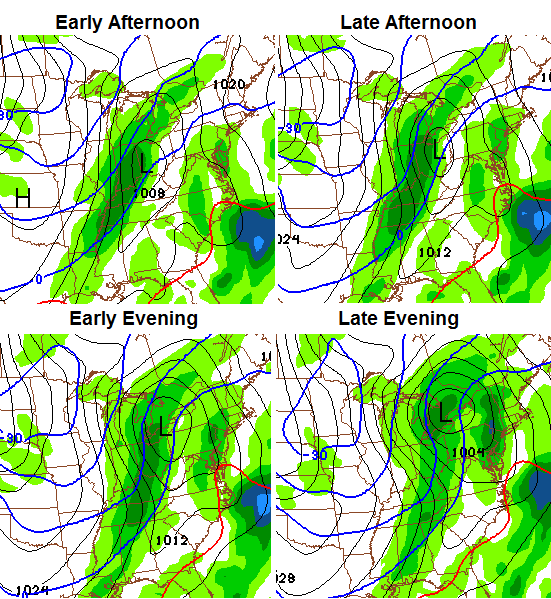
That shows up well on the above maps. The latest run of the GFS is now putting quite a bit of snow down across the state…
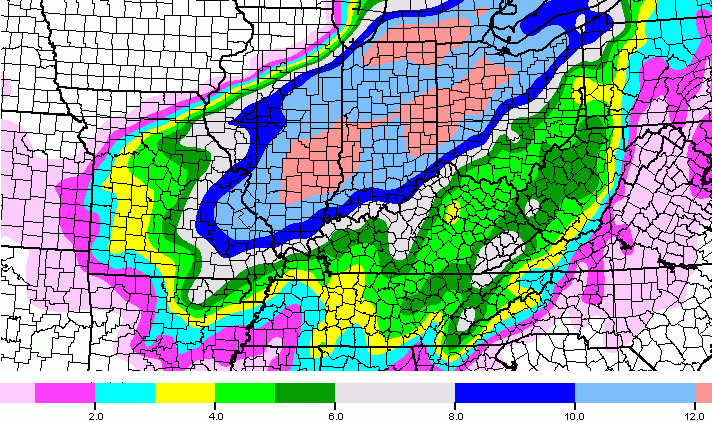
The temperatures coming in behind the snow are just downright dangerous…
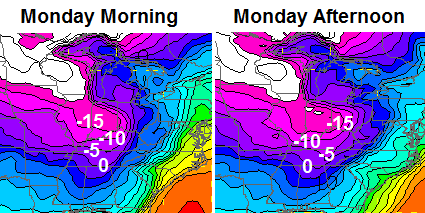
That’s just unreal and could be historic across the Ohio Valley.
My thoughts on how this plays out:
– Snow develops behind the front in western Kentucky by midday Sunday. Ahead of it… a line of showers will be possible with temps surging toward 40 or a little better.
– The arctic front slams eastward during the rest of the day and a wall of heavy snow follows it across the state. Widespread 1″-4″ totals look likely with amounts approaching 6″ possible for some areas. This will turn into a powdery snow that gets whipped around.
– Wind gusts of 40mph will accompany the wall of snow and this may create near blizzard conditions for a while.
– Temps go from above freezing to below 0 in a matter of hours.
– Wind chill readings on Monday may approach -30 or lower.
I will have updates as needed. Take care.

Ahh finally!!! A winter storm!!! Although I’m excited, I hope everyone stays safe and stays indoors
there you go Bubba hope your happy 😉
Bubba has got what he’s been looking for 🙂
Hasn’t happened yet.
its being discussed which is one of the things he was looking for
Yep.
Bengals game Sunday afternoon could be interesting.
Can we even watch it? They were saying lat night the game would be blacked out for our area if the game did not sell out. My guess is this event will not help sell it out.
Game sold out. No blackout now.
has already sold out!
You may be right. Ridiculous NFL rule. Its a playoff game, for gawd’s sake.
They got the sellout. No blackout.
The game would have been televised in our area irreguardless. Only the Cincy area would had been blacked out.
Thanks for the update Chris lets hope it all works out as you think
Thanks Chris, you ARE the man!
Sounds like a brutal forecast for livestock. A cold rain to get them wet and flatten their winter coats, thus taking away a lot nature’s insulation, then rapidly dropping temperatures and unreal wind chills.
Better round them up at put them in the barn!
Chris, I am headed to the Bengals game on Sunday (traveling from East Kentucky). How worried should I be regarding slick travel?
Odd Question: Can cats survive this? We’ve build a small winter house for the cats that has been good thus far, and I’ve moved it under-roof of the porch, but will the temps be to low for cats? Any thoughts or anyone live near London with a “warm” barn?
pardon my typos
Don’t know if you have electric, but if so, purchase a heating pad and set it on low and cover it with a towel. Have done that for years with great success. Other than, that hay and towels and flannel should work.
Thanks…great idea!
We used to keep a bare light fixture with a 100-watt bulb in our doghouse. The animals did fine.
sure wish we could get some snow in Tennessee
You and me both !!
Wow is all I can say and Hi Tim we miss ya.
Looks like we might get some snow here in Athens tn. Out of this one..!!! This snowbird is ky. Snowbird starved!!!
Wow!!!! And IBIWISI.
Thanks for the update CB. You do seem pretty confident in your post. Hope it works our that away.
My blowtorch has been extinguished lol. Pretty broad on the snowfall amounts. Seems like the models and setup supports a widespread 2-4 inch snowfall, with several spots approaching 5″ . Looks like polar express will offset any long term upslope squalls
Maybe your torch has just been delayed. February could be warm. You never know.
Wait…. Did you say -30??
Am greatly enthused with Chris’ ideas. Some of the other websites I follow showing/talking less snow in KY but I’m on Chris’ team! lol
Seriously, get prepared. Get some groceries, disconnect any water hoses outside, fill car with gas, etc.
Also, I expect a Winter Storm Watch from Paducah NWS at any time.
Thanks for the updates Chris! As a teacher in a local school system I am baffled by people already complaining that they may even consider calling off schools for the cold. Seriously? I’ve had individuals on my timeline repeatedly say things about being from the North and they’d laugh at us. Well guess what? We aren’t from the north and therefore we aren’t prepared for temps like this. Parents may think their kids are dressed warm enough when they put on their coat and hat and gloves and send them out into the negative temps, they’re not. We have parents who walk their kiddos to school daily because they don’t have cars and kids that stand out and wait for the buses. And if a bus breaks down it can take 20-30 minutes to get someone to them. So yeah, it’s not simple. So many factors in play. It may be an inconvenience, but it’s better to have your kids home inconveniently than to have one child injured or dead from the cold.
They use to back when I was in school use mud/snow tires on buses now it strictly highway treads and is why they get stuck so easily. If all drivers and garage folks took care of their buses then there wouldn’t be much canceled because of cold. I do believe if it does snow Sunday 4 inches or so there will be a few schools who will be out all week based on the cold showing up.
I have friends that laugh at us all the time because we “can’t handle the winter”. They can stuff it. Our building heating systems are no more equipped to handle cold like this than our cooling systems were equipped to handle the heat wave of two summers ago. This event is called “extreme” for a reason, and calling off school due to cold like this in our area is perfectly valid and reasonable.
Plus, most buses will not start w/ temp at 7 degrees much less below zero!
dang settle down people …. it’s only his opinion, some of you act like he turned water into wine. it’s 3 days out — indeed it is going to get cold, but the snow, come on …. we’ll be lucky to get 1 or 2″ at most
You must have read the same forecast discussion out of the Louisville NWS that I did.
2 days 🙂
I agree with you. 1 or 2 inches.
I am a teacher as well and that being said I work in a county with back country roads and students who have to take the bus and walk. I would not want my students out in this cold either! It would be a risk to put buses and kids out there with that extreme cold!
Dare I say — Old School???!!!!!
Thanks, Chris. Never a dull moment, is there? 😉 by the way, great call on the system that moved through here yesterday. It was spot on.. Went to lunch with it raining and before I got back it was snowing and raining. Then when I went to get in my vehicle to go home, the door handles were frozen shut. I take what Chris says very seriously. Others should too, regardless of the snow factor. The temps and wind chills are going to make it brutal.
blizzardtim does it look like Morristown TN might get any snow
Potentially, as well as Knoxville, Tri-Cities and possibly as far south as Chattanooga/Northern Georgia
Winter storm watch now for Louisville and surrounding counties. Think Lexington area gets added sometime tomorrow.
That is the strangest looking WSW I have ever seen, one or two counties wide from Louisville south to Tennessee??
A heavy band of snow or deformation zone which ever you prefer is likely to occur where the county’s in KY are under the WSW. Thats the only thing I can come up with.
Now the entire western half of KY has been added that looks about right now!
Only 48 hrs away. Not 3 days. Lol.
Even The Weather Channel has most of KY in the 3-8 inch range of snow fall…
this is from NWS/Jackson
http://www.crh.noaa.gov/images/jkl/ConferenceCallBriefing.pdf
Also just in the SPC just came out with the snow map things have really shifted south for snow which if your a snow lover you will like. County’s along the ohio river your now in the 40% of 4 or more inches and the 70% line is very close to the county’s that border the ohio river. Western KY is now in the 40%. Central KY and points east is in the 10%. Central KY and points east dont get discouraged its a big shift to the south and east since earlier today its starting to trend south. Remember this is SPC map.
Where do you get that map at? I’ve been to the SPC’s website and can’t seem to find it.
he meant WPC
I’m looking forward to the snow, but not the cold!!!!!!!!!!!!!!!!!
Chris do you think the East will be added to the advisory?
I wish blowtorch dude would have been right
Test
My posts are being eaten by the machine.
The weather channel has most of Kentucky in the 4-8 inch range besides southeast ky
We have been bad Corey lol.What do they have for us?
It says 1-3 but more on the hill tops..but I’m sure the weather channel will change 3 times before Sunday hahaha
CB said 1″ to 4″ and a chance of some getting 6″. I’m sticking with my call from several days ago: Ankle biter and -4 for the average low. Seems the likely chances are mainly I64 on up, but some will try to will it south.
Just a few inches of snow blowing around will be interpreted by some as more than it is. Kind of like UFO sightings 🙂
Bubba buster? There has only been one and that was a clipper, five yearn’ ago. Will more be part of a storm, or is this destined more for I64 and an advisory at best for the rest?
The trend is a powerful force of the Dark Side. Kuuuuhuuu!
Just remember in the end the dark side fails and we all end up with a old school Bubba Buster! 5 to 8 inches or more Bubba, even south of the river 🙂
2″ to 3″ is an ankle biter, so I guess that is really no different from 1″ to 4″. 6″ would be North of 64. Same call really. My emphasis is biased by the heart of the Snow Death Star: CKY
im sticking to my THUMPER WITH SMALL CHANGE, UP MY TOTALS TO 10-16 INCHES..inches!! not be a dangerous cold without a THUMPER
That would be wild lol
I didn’t know they legalized pot in KY 🙂
He just got back from Colorado. He rolo-ed a big fat joint!
Who needs legal??
all of ky WILL HAVE WSWARNINGS SUNDAY
I was just playing rolo …… I really like your posts …. I wish all commenters were like you and bubba
Agree completely…..gotta love the ROLO posts 🙂
Geeze you would think that rolo turned water into wine. Settle down…..dang. 😉
Be afraid, be very afraid… of the trend…
Kuuuuhuuu!
If we have a Bubba Buster I want you out that broadcasting Live for KyWeather like Jim Cantore!!!!
Speedos drinking a Bud 🙂
You have heard here first lol.
I like the new NAM which is just rolling in. Chris, I’d appreciate your feelings on what is moving the actual low pressure system further to the east on the latest run and also whether I am interpreting it right. My guess is the front is moving faster in this run than the previous run or low pressure is forming further to the south. Thanks.
I said in morning thread WSW would be going up for OHIO RIVER WESTERN areas. so what im hoping the westerly trend as we get closer for so many years will actually reverse as this ARTIC COLD not coming without THUMPING the whole central/eastern part of state. just aint going happen. it will not be below zero temps if it does lay down 8 plus inches of snow.
OLD SCHOOL!!!!
Does that go for us in the East Too Rolo??????
temps will be below 0 with 4 inches of snow Rolo
HAVNT SMOKED POT IN 6 YEARTS sbreeze.. and ur coment was fine as im a fun luvin redneck guy.
I ask u all to send me friend request on facebook. im friends with several here so go look thru there friends and find me.
How can i find you on Facebook Rolo?
Yea tool how we fine you on Facebook you to crystal?
Marsha and Rolo it is Crystal Jr Ray
Crystal I sent you a friends request…
How do I fine you Rolo?
Rolo is Lewis Rolo Roberts
Rolo my finger got excited…lol
Chris next up on TV, Should be interesting!
This is so much like January of ’94. We had a night of around 0 temps and a day with a high in the teens a few days before the big storm hit. When I went to bed, the forecast was for mainly freezing rain and about 1-3 inches of snow. Woke up to 17 inches, temps continued to crash for about 48 hours afterwards going down as low as -37 in Shelbyville. I wouldn’t bet against a repeat–the event in ’94 was not expected.
Of course, the one thing in that ’94 event that is different were the temps at the onset. It was in the teens with freezing rain! That’s how dense the low level arctic air was. It actually warmed up as the snow began to fall.
This does have a similar fibe to it, even the weather channel is showing 5-8 inch snows for most of the state now!
NWS Still not buying in Yet?
I don’t think anyone bought it in ’94 till it happened. I went to bed thinking we would have a little snow. That was about 12:00. We had had a good bit of ice and sleet. I woke up at 6:30 with 17 inches! It must have snowed 4-5 inches an hour for a time. To this day, I wish I had stayed up to see it!
I did stay up all night and watched 3 inches per hour for 6 straight hours!
I figured it had to be a crazy snowfall rate.
I remember the ’94 storm so well but didn’t remember what the forecast had been beforehand. I really feel for the Mets, because this could blow up into something huge, or could be a bunch of cold rain with just a little bone-chilling snow on the backside.
Don’t fall for it fellow former Marine! This seems destined to be an ankle biter for all but north of 64. 64 North decent shot at a storm.
Not seeing anything to go beyond 3″ for most. Yet, anyway.
Bet all eye’s are on the GFS right now..
And, hot off the presses the NWS in JAckson downplaying snow for its western counties. Areas like Somerset to London and Corbin to Barbourville can expect less than a inch of snow. I guess we will get an advisory, if we are lucky. Once again, the north gets all the good stuff. Enjoy it Louisville
Because of the NWS? Hardly
CB, I hope you nail it. Are you disagreeing with the NWS forecast for it’s western counties? (JKL)
I have to agree the new NAM just came out places like Louisville and county’s that border the Ohio River look to get a real nice snow as it stands now 3-6 is a pretty good bet. The NAM said BAM for north central KY.
Better discuss that with HPC they have us with a moderate risk of 4+
Andy, the setup just seems to favor a very widespread 2-4″ or isolated 5-6.” The wall of snow and wind that will crash through here should be something fierce.
WPC Graphical Forecast grids have updated. 70-80% chance of snow being greater than 2″ but less than 4″ for the next system. So right now a general 3″ is being forecasted. Will keep an eye on the grids and see if they go up or down by tomorrow. Should be a better synoptic standpoint by then hopefully.
http://www.wpc.ncep.noaa.gov/pwpf/wwd_accum_probs.php?ftype=probabilities&fpd=24&ptype=snow
Showing 40% of 4+ for my area
AKA: Ankle biter 🙂 😉
I don’t know where a lot of you are getting that temps were below 0/in the teens prior…unless that’s just in E. KY. Here in Nelson Co/Bardstown, we had John Belski spouting off about a week ahead of time about a “major snowstorm” coming around that w/e, but by that Sun. afternoon during the Niner’s game, they scrolled across the top of the screen “Less than an inch accum. in the L-Ville metro area, blahblahblah…”- I went to the store and didn’t buy anything more than what would supply my work lunch next day, figuring I’d stop after work when I got paid on Mon. and buy groceries…woke up around 3am, it was ‘spitting’ snow…get up @ 5am for work, it’s STORMING?!-while the peeps on radio are talking about all this snow north of us, roads closed, etc??! I finally looked out to see around 16″ of “Thundersnow”…. 🙂 Hope it’s like that again. I sure could use it.
Sorry…I got off-topic…temps were around the mid-30’s/low 40’s here prior to the storm. Sorry! 🙂
The day the storm began in Louisville, Jan 16th, it was -3 at 8:00 A.M. Temp rose to 24 when the freezing rain began. Sleet by 11:00 P.M. and then snow by midnight. Temp rose all the way to 32 by the morning of the 17th, then fell steadily to -10 by 9:00 A.M. on the 18th.
Same in Frankfort!
Whatever. I just know that in Bardstown that day (Sunday) it wasn’t all that cold…we had a light rain when I went to bed that evening at arouns 11pm, thinking, “Oh, hell..no snow, gotta work…grrr!”…until I got up on Monday…still not that cold..
In January of ’94 or even ’78 we would have all been screaming “that low pressure is going to far West.” In both events, it turned out well for snow lovers for most of Kentucky. Not saying it will happen this time, but it could. That’s what makes this fun to follow!
Chris was saying that the bulk of the moisture with this storm would be on the back side of the front, so it’s a back-end loaded storm—which is generally what you need for heftier snowfall totals—a lot of the ones that fall apart for us here are usually too front-end moisture loaded and why the warm air advection kills our chances.
We need a very generous deformation band of snow to envelop all of us snow starved central and east Kentuckians. Usually I agree with NWS JKL, but calling for <1" of snow is way too conservative.
Any snowfall maps available from that January 1994 storm online? I was living in Louisville at the time, and of course we got drilled with 14 plus inches. But I”m not sure how southeast and south central Kentucky fared.
Not sure either. I know most of Western, Central, and Northern Kentucky was slammed. I’ll look for one.
See if this link works. http://www.crh.noaa.gov/images/lmk/top20/17jan94snow.PNG
Thanks Chris, great overlay of central KY, wish there was one that extended east into eastern KY. Andy, or any other southeast KY poster, any recollection of the 94 January storm?
Not much change..Looks like middle tenn. may get a good hit..
to my untrained eye..the 18Z NAM has trended further southward with the low pressure…will be interesting to see how the GFS looks.
Yes, you are correct.
The weather less channel flops every few hours on the track of this storm, had 5-8, now 3-5, this will be another NOWcast storm as usual!
Those are state wide totals!
Chris, Thank you for all you do to keep us up to date and informed about our weather. I’m traveling to Cincinnati from East KY this Sunday for the Bengals game. How concerned should I be? Do you think the really bad travel conditions hold off until later Sunday night (7-8pm).
Ok snow lovers…..lets cross our fingers and toes for a big snow! So tired of seeing pics on Facebook of my friends back home in in Maryland and Pennsylvania with all the snow they had so far this year! This girl is getting jealous! BTW…..I don’t post much on here but been getting all my weather info on here for the past 4 years! Thanks Chris Bailey in all you do! By far the best weather dude! Enjoy reading every all the blog posts on their thoughts.
Sorry for the typos!
lots of cool discussions and predictions. this is exciting stuff for sure.
relative to ’94, does anyone remember if Chris had it as one of his analog years and was that the year of the thunder snow?
I apologize if this has been discussed above-ton of posts!
Yes and yes.
thanks eyewall-appreciate it!
The GFS has trended with the NAM with north central Kentucky getting a hefty snow
Lets hope the models don’t smack us with another let down in KY, this one for some reason feels different, time will tell as always!
As someone says on the Blog! THINK SNOW 🙂
THINK SNOW!!!! Comes from Belski here in Louisville. Used to be my favorite met. Now it is CB.
by the way Belski is waiting until after 2 am before deciding on track of s
Can someone post the latest gfs or nam please.
http://grib2.com/gis-snow-overlays3.php3?BASEHR=18Z&STATIONID=JKL
That is the 18z NAM. I’m not positive, but I think it’s on the 10:1 ratio.
The 18z GFS hasn’t been published yet on http://wxcaster.com/models_main.htm
Thank you you are too kind.
Already down to 15 here in Lawrenceburg. High today was 21; low was 1 above. That’s wicked enough. I’m pretty sure the forecast low of 16 is going to bust on the high side–as did last nights’ low!
Jeepers, we were at 22 when I checked ten minutes ago. In Richmond ChickfilA at the moment. That is a big difference.
19 now
Holding at 14 here at 7:00. My thermometer is in a shaded area about 5 feet above ground. Might not be totally accurate, but it has to be close. The snow makes all the difference.
What are the snow ratios for this upcoming storm?
Maximum ratio I do believe.
It sounds like here in East Ky right now the change over isnt going till be about 9pm if thats the case we wont have time it seems for much snow I hope I am wrong.
There is going to be very little rain in front of this system and the changeover will be very quick. East KY should see continued snow showers throughout the day on Monday as well. I think you are sitting fairly well from the snow stand point right now.
Thanks Big Papa,I guess we will all find out together lol.
I am in Morgan County. I am positive that the January 1994 storm felt similar to this. I remember going to sleep and figuring we might have a day off from school (I was in HS). Woke up the next morning to no power and we missed over 2 weeks of school. My house was without electric for at least 2 weeks. I remember this well as I got my drivers permit in February not long after things started getting back to normal. I really hope this is not one of those types of events where things come together just right and make a huge mess.
John Belski said the latest NAM shifted the Low 100 miles south. However, they are waiting to see if the other models trend that way.
Don’t tease me Craig 🙂
What does that mean.
see the graph Christ produce for total snow accumulation.
drop it hundred miles south.
Maybe we need an intervention from the Son of God to get a good snow here 🙂
I have been praying for a biblical snow storm 🙂
Todd–I hope we don’t get struck down for blasphemy!
It means good things for kentucky ! 🙂 keep fingers crossed
Especially for north central ky
GFS Meteogram from KJKL just showing 3 inches…Nam is only showing about an inch..This is a ratio of 11:1..Here is the one from Jackson..It’s a large image..Will post it next post if anybody is interested at looking..
http://www.meteor.iastate.edu/~ckarsten/bufkit/images/plotter.php?site=kjkl&var=snow_accum&nam=1&namm=1&nam4km=1&gfs=1&gfsm=1&rap=1&nam_mos=1&gfs_mos=1&gfsm_mos=1&nws=1&obs=1&con=1&max_t=1&cobb=1&compaction=1&ratio=11
I don’t really get that map lol
Its just data all put in a grid from the jackson weather office….The whole meteogram shows temp,dp,etc..search meteogram generator on google..neat tool..
Actually the 18z GFS is giving 3.2 inches..12z was giving 2.9..Trend maybe?
GFS at 18z looks further east/a little further south.
All good 🙂
Better than a northern shift!
18 (the mets that blew badly yesterday’s event) are saying only light snow for Sunday and are sticking to their warmer temps. About 5 degrees warmer it seems than 27 mets. That at least went down 5 degrees from this morning.
Will they blow it again? Will Rolo do the choom choom? Not long to find out 😉 🙂
BM has never witnessed an old schooler in KY, since he is from Chicago, he has mostly seen our blow torch winters ( thanks Bryant)
That being said he is a rookie compared to Chris who is a home grown KY guy which knows our winter weather patterns better!
I’m in Ohio County, about 20 south of Owensboro, KY. If I’m looking at this map right, with the 100 mi south shift, it looks awesome!! I’m a hold out for those 70’s kinda winters!!
You guys have already had plenty of 70s style winter events through the years. Us central KY folks have been stuck for 16 years 😉
Sadly, I am not seeing this event get us unstuck. Ankle biter for most and maybe more for 64. WLEX though could be messing up badly like they did with yesterday’s event. Mix and light snow is their call with no snow estimates yet.
There would have to be a profound shift SE to get more of Kentucky into the potentially heavier stuff. Not just due south. It would need a mega ultimate shift for that.
You would think Ratios would be higher with this system..I will say ratio of 15:1 or higher..With those ratio’s parts of SE Ky goes from a predicted 3 inches to my prediction of 8 inches..lol..Im riding the rolo train..
For SE Kentucky to get nailed, that would be one serious south and east shift. Due to the track, the southern shift would have to go way south since tracking to the diagonally to the NE.
If it happens, cool. Well, COLD! Brrrrrr!