Good Friday evening. I really have no changes to make to the thoughts I put out there earlier. A Winter Storm Threat continues for Sunday and Sunday night.
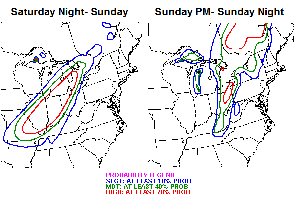
The Weather Prediction Center (WPC) is also buying into the possibilities I am outlining with the band of heavy snow behind the arctic front. The have a slight to moderate risk for 4″+ snows out for most of the state…
The late afternoon run of the GFS really ramps up the snowfall…
 I think too many people are looking at just the wave of low pressure and not the heavy band of snow that comes behind the actual front. THAT is what will put down the majority of snow across the state… especially during the afternoon and evening hours.
All of that leads us into a brutal air mass for early next week. Now is the time to prepare.
Take care.

Wow! Gonna be fun to see it all come together this weekend!!
Thanks Chris
Temps are continuing lower than forecast here in Lawrenceburg. Now down to 13. Even if it gets a bit warmer on Saturday/Sunday I doubt the ground temps will go above freezing. That means whatever snow falls should stick.
If this hold through morning a Kroger stampede tomorrow, bread and mild shoulds good already!
Rolo, quit typing for me 🙂
lol
Hahaha!!! Been on here long enough to understand that one!!!
Looks like a rolo-coaster coming…..
and in other news… a bread and milk advisory is out for all of Kentucky.
I couldn’t agree more with your point about wrap-around moisture having the potential to lay down copious amounts of snow in a relatively short time-frame. 30 years of experience as a weather spotter in eastern Pennsylvania, sprinkled with a fair number of Nor’easters taught me that!!
The NAM is starting to join the snow party as well. It is not as robust as the GFS, but it is heavy for the NAM. The 00Z Euro will be interesting tonight. I have a feeling Dr. Know is going to lean toward the GFS model for a change, and go with a colder solution for our neighborhood. If someone had a gun to my head for a snowfall prediction, I would be in the 6″ range for the Louisvillle Metro, which is a blend of the 18Z GFS and NAM. Take care, and prepare for the cold.
http://wxcaster.com/gis-snow-overlays2.php3?STATIONID=LVX
Oops posted in the other thread..Here’s my thought’s..
You would think Ratios would be higher with this system..I will say ratio of 15:1 or higher..With those ratio’s parts of SE Ky goes from a predicted 3 inches to my prediction of 8 inches..lol..Im riding the rolo train..
Can’t wait to see how this storm plays out!!!
Why on earth are the NWS offices sitting in their thumbs with such a high impact event on the way? WS Watches need to be out for just about the entire state.
AGREE! and I’m sure Chris does.
Not sure why anyone cares what the Jackson NWS office has to say. Only “innaccuweather” is worse in forecasting winter weather. Just saying….
I am committed to an ankle biter for all but 64 north, so no turning back. That said, I am not met, but WLEX are and they are sticking to the mix and light snow for the state. They are saying this is a cold event and just a little snow.
They are 0-1 so far for 2014. CB’s thoughts make more sense than theirs for Sunday. 0-2?
All I can say for sure is that temps have been lower here than forecast that past two days. I’m about 8 miles south of 64 and 5 miles north of the BG, and 3 miles West of the KY river. I’m really on the “fence.” I just have a feeling this one is going to surprise most folks.
Preach it brother ( no pun intended 🙂 )
But this storm is going to bring a smack down for most of KY!
I said it before Rolo Can!
Hey Rolo, where are you, gambling on the ponies again??
No pun needed. I am an ordained minister after all…:)
It’s just not C.B.’S thoughts, The Weather Channel is on board with snow in KY as well…
I was looking at the map and it was showing rain and a little ice for most of eastern KY. I am in Madison County and it is saying rain to snow for me. 🙁
worked out good for them last time 😉
Got that speedo Ready?
http://www.speedousa.com/family/index.jsp?cp=3124322.3124332.11859612&categoryId=3124355
Bubba has agreed to Broadcast live in a speedo if we get a Bubba Buster.
Less than 48 hours out and no one has a clue about the storm.
That is the truth…I am with BubbaG….North of the river gets the smack down. Everyone else 1-3….Even if the models are trending south/east. They ALWAYS go back north/west day of event. TRENDS for Ky. Not going off of NWS….CB…or any other met in KY…Going strictly off what I have witnessed the day of and that is Cold rain that never turns to snow. Sorry to be a Debbie Downer as I am just a another snow junkie that knows we are very overdue for a TREND BUSTER……..THINK SNOW!!!
One good sign, their is accumulating snow forecast as far south as Alabama, so atleast we are not on the fringe of the accumulating snow this time, a little room for era this time!
Good catch and very true.
If we look at the track of the system, it is diagonal due NE. If it shifts south, that only gets part of the state in the heavier zone. The system needs to go south and east big time to impact more of KY with more than a few inches.
Heck, it needs to shift south some just to get the few inches. Snow fans need to mind meld and think south east 🙂
How many times have we seen storm start shifting south and appearing tp put us in the sweet spot to get just a few hours away from event to watch it make north jump? I hope it does not this time but we have seen it many times
I’m headed to Cincinnati Sunday for the Bengals game, traveling from SE KY. I’m hoping to make it home before the real nasty stuff starts. What are your all’s thoughts?
I think it’s gonna be a great game.
Safe side…book a motel and enjoy the game!
I agree stay up there and who Dey!!!!!!!
can anyone tell by those maps if it looks like Morristown Tennessee will get any snow
I would say 1-3 inches, not a MET but Maps are showing it!
Yep..That’s what the Morristown NMS was giving earlier..
Yes. Most of East Tennessee including the Morristown, Knoxville, and Tri-Cities metros and as far south as Chattanooga/Northern Georgia and into Alabama. A good chunk of middle Tennessee including the Nashville metro should see snow as well as long as the maps don’t shift much between now and then.
Thanks Todd
Your most welcome, and if you like snow, I hope you get plenty
Louisville met downplaying snow (so it begins) http://fox41blogs.typepad.com/wdrb_weather/2014/01/a-significant-snow-is-likely-in-part-of-our-area-this-weekend-lets-talk-snowfall-totals-for-your-are.html
wow…what model is he believing (or not) in? So, anywhere from 1″ to 6″ for Louisville? I’m going with Chris!
All do respect, but I think that is a opinion that seems dated or atleast several model runs old, he is saying 1-3 in Louisville where their is a winter storm watch? 1-3 not watch criteria?
Yes, he posted it at 8:00 pm. Other stations are saying 3-5 for Louisville, 1-3 for south of metro.
I get the Louisville METS here in Frankfort on TV, they are known for playing the safe undercut route at first then catchup if needed during the storm!
That’s why we love Chris, he calls it as he sees it and does not worry about the final numbers!
Thanks, Todd.
We normally get a Winter Storm Watch when conditions favor a potential for snow of x amount. When combined with falling temps and strong wind, a 1 – 3 inch snow can cause near if not blizzard conditions. This is probably the reason a winter storm watch has been issued. Also, a watch can be downgraded to an advisory, but I believe most areas will be under a warning for said criteria above.
Whas 2-4 Wdrb 1-3 Wave 3-6 im not sure what Wlky is predicting. The met from Wdrb has the rain transitioning over a little bit later than the rest of the Louisville mets. Being that said most mets saying nothing set in stone.
NOWCASTER!
WDRB just said the the new NAM computer model is rolling in now with the storm initialized in the US. They say it is a much warmer solution for Sunday.
Well it’s 12 in frankfort at the moment, let the games begin 🙂
The Louisville mets are getting worse and worse with each storm. They hype 1-2 inch snows. With this storm they aren’t hyping much so probably get slammed.
Well, now they are saying all rain for Louisville. (That’s why I come here.)
He always downplays every storm and is known to met bash others forecasts including the NWS. This is nothing new
As much as I love watching Marc, I think he is forecasting too low for this storm.
As much as I love Marc, I believe he is too low on his snow totals. He was also wrong about the snow we were supposed to have Thursday morning.
So nice of the ones that took the time to answer my question. Here’s hoping if you want a big snow that you get a lot.
Awesome job Chris!
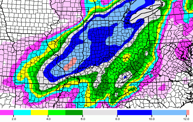
00Z NAM has the low cutting up from around Memphis, TN through or near Louisville, and up to the eastern lakes. Sharp north/south band of heavy precip just behind the 0C isotherm on Sunday.
well watch the euro show 8 -12 state wide, next GFS will be same. and tomm morning NAM will have 6-12 state wide. then by tomm nite this time all models on board with a blizzards.
Love it!
lets go old school, the time is NOW 🙂
Rolo, how is the system track going to move that much south east? Due south will not get it there, since the flow is diagonal.
You are saying watch the shins and I am saying watch the ankles 😉 Of course, the host of the blog has obvious call honors. Well, that and he is a real met with real skills 🙂
Models will shift and move and dodge and shiver! Nothing set in stone and predicting heaviest snow bands is nearly impossible. Dodger!
The low coming from the southwest is not even showing its self yet, you gotta love all these early forecast 🙂
I’ll wait to see if Chris backs off any later, before I latch on to any trends!
What would that mean for louisville?
So another near miss is on the way, I guess?
Well us folks in SE Ky sure would hope the Nam is way off..Looks about like a lakes cutter..But on the bright side Western gets a good thumping..
The NAM said there would be little if any snow with Yesterday’s system. It’s no longer a good model.
Oh thank you wise one..You have rekindled my spirits..I’ll put my money on Chris instead of the Nam..
Yeah…NAM vs. everybody else at this point…Even ILN (NWS in Wilmington) is noting that the ECMWF is out to lunch lately…but you can’t tell by their Winter Storm Watch that they are leaning towards a GFS type solution ha ha.
Maybe it was off overall, but if that was what the NAM said with the last event, then it correctly predicted the 1/2 of an inch of snow received in Berea.
Why is the NAM being taken so seriously versus the other models??
Thanks Chris, you answered my question while typing 🙂
Has a lot to do with “wishcasting.” If the NAM or GFS or Euro shows someone getting a good snow, then suddenly, it’s “the best” model.
In all honesty, this season so far the GFS has been the most reliable model. It hit this past system real well. The NAM has been horrible this season and the Euro which has always been the more consistent models has been all over the place recently, finding and losing storms multiple times daily.
The Euro got an upgrade in the late Fall that seems to have caused it problem with moisture amounts in the US.
Conversely, if a model is the one showing bad results it is the unfavored one 😉
Seems the event yesterday and the expected one are two different flowing systems, so what the NAM bunked on the last one might possibly not be the case here.
Not to mention those percentage chances CB posted above are not exactly high for a lot of KY. It will be interesting to see CB’s further discussion.
NAM lately though has become a new waffle at iHOP 😉
They also have the rolo waffle on the menu.
The Choomer Special 🙂
Systems that move NNE from near Arkansas thru central TN, then up through eastern KY and then due north up through OH and MI have thumped western KY very hard in past years. This one appears to have a similar trek. Guess we’ll see!
Come on now,don’t be hogging all the snow..Seriously hope someone in Ky gets a good one..Lord knows we are way over due..
I want all of us to get a great snow. However, that’s a very rare bird. KY is a very wide state with varied terrain, and there’s nearly always gonna be an area or two that gets very little when another area gets it good. Remember, though, that western KY gets zero upslope snows. We were bone dry last night when eastern KY was getting 2-3″
Even though they change it a lot, the Weather Channel now has almost all of KY in the 3-5 inch range for snow!!
The weather channel is still showing 3-5 inches for the Somerset area!!
So I guess everyone is saying eastern ky is not going to get much out of this storm does anyone else on here miss Mitch I sure do….
Apparently the NAM is saying that, but CB is saying to not trust it. I would just sit back and wait for the GFS to come in. It’s been pretty much rock solid for the past two days on this storm so if it keeps its consistency then I would put more stock in it right now.
Funny that people posting on hear always call out the model that is the negative outlier. That steams from years of being disappointed! My take won’t know till late tomorrow afternoon how much snow we will get out of this. Just my take! WW
That is the most correct statement of the night! Lets see what tommorrow brings, then we can prepare for what ever the flip flopping Models say then with more confidence!
This is why CB is canning the NAM.
http://wxcaster.com/gis-snow-overlays.php3?STATIONID=LVX
and the 18Z run. It is everywhere, and nowhere at all.
http://wxcaster.com/gis-snow-overlays2.php3?STATIONID=LVX
Looking at those I would take with a grain of salt, just look west in Indiana where it is showing 2 or 3 inches also, most folks their are calling for a foot or more in those zones????
Just a reminder about the cold..With maybe 40 mph winds electric could go off for some..Keep an eye on the elderly and pets..Be nice..We may need help ourselves one day..
gusts
Good point! I kept my eye on the pup tonight when I let him out. I really should learn to be more patient though. He was taking forever but as cold as it is it not like I would want to be outside taking a crap in the front yard on night like this! Tuesday will be even worse! HA HA! WW
Weather Channel has most of KY in 3-5 inch range….
00Z GFS has started! Let the fun continue.
13 degrees in Frankfort, if we get mostly rain Sunday that will be another major miss for KY!
Heck, some folks in southern Indiana will be approaching 30 inches of snow for the winter if the forecast verifies!
GFS is also coming in warmer according to WDRB….maybe it will be like 1994 and they will keep lowering the totals and we end up getting 16 inches.
00Z GFS temp profiles are coming in too warm. The 00Z panel shows St. Louis just above the 0C isotherm, and they are at -4C. Columbia, MO is at -3C. You have to get out to K.C. to get above freezing at 2C.
I see a little girl in the distance with a hat, coat, gloves and a football all teed up and waiting for the swing 😉
That,s me lol.
I have accumulated 20 bubbacoins from the last storm. Perhaps I will wager on this one too….
Whats disappointing is that storms never trend towards the better in or area. If they move in a particular direction, it’s always in the direction that means less snow.
Honestly, when was the last time a storm kept looking better and better on the models as we got closer to the event? I’m hard pressed to remember.
Chris just posted that he has no changes to his forecast..still with a heavy wall of snow
Yes, but still talking a few inches for most and not a big snow.
From Kevin Harned of Wave3:
The new (00Z) NAM is in… and is farther north. Meaning a later transition to snow & less accum. I’m not in total agreement. I’m banking on upper air meterology forecasting of the cold air moving faster. At this point I think the transition occurs by mid morning with a 3″-5″ total for the metro still a possibility. There’s a chance the 00Z GFS will offer some help – either in agreement with me or the NAM. We still have time to adjust the forecast… we’re more than 24 hours away from the event! Stay tuned. (You can compare this map to the previous run Ryan posted below) -KH
The 00Z GFS Model keeps the 0C isotherm near the Ohio River for much of Sunday morning into the early afternoon. It then displays a Low southeast of Louisville, in the 05/01/14 18UTC frame. It runs the low northeast up the apps to central New York around 09UTC on 06/01/14.
CB said the NAM ain’t BAM for this one, but in the past it was. Sure it can waffle, but so can the others. It was NAM says BAM and Hello NAM just the other day. Why is NAM no longer an “in” model? One miss and out the door. That is a tough standard 🙂
Just messin’ but still not understanding the dismissal of the NAM.
The NAM was colder and snowier earlier today, but it can’t zero in on a warm or cold solution. It keeps drifting like a drunk.
The interpreted success of the forecast seems to be based on result of what falls around the station building itself, so whatever model retroactively matches that result will be the ‘correct’ model.
Another fizz out, what a shock. Rather take my blowtorch than cold rain followed by a skiff of snow and single digit readings. Best analogy I have for Winter in KY is to UK Football. Always promising before the season starts, then one disappointment after another
True so far.
Looks like the zero zulu GFS didn’t warm up too much on Sunday/
In the interest of transparency, I live in Clarksville, IN.
Still didn’t look bad to me..But hey I’m always an optimist..If we get snow fine..If not then the sun will still rise tomorrow..
CB is still talking mainly ankle biter for most. A WWA seems the best case. Not me talking, but CB just now. The main stuff is too due north east it seems to go as east as folks here want. That last sentence is my conjecture.
Chris said on TV maybe a couple inches?? WOW another rain backend light snow system, followed by brutal cold!
I was hoping for better, looks like our toe biter continue!
I’ve always loved snow and probably always will. I love to get out and walk my dog down the street and look at the covered trees and mountains but I have come to the conclusion that I really don’t care if this particular storm happens or not. With the extreme cold, there will be no way to enjoy it. I have absolutely no intentions of leaving the house in sub zero temperatures, even for a few minutes.
Weather channel still has kill of Kentucky in the 3-5 inch raise with locally higher amounts
All of ky*
Models are jumping with each run, earlier tonight it was all about the southern shift, now the northern shift, NOWCAST folks is what KY winters are all about!
Am I mistaken of does this run of the GFS show the low over east ky at 48hr. And it shows most of the precip. behind the 0C line. I know it is one run and will probably shift but I would think that would be a better setup for snow.
Oddly, I look at a certain forecast and they have slightly raised their Monday-Tuesday temps and have dropped snow from it as well. They have Wednesday at 34. And then have Thursday on as mid to upper 40’s. I noticed they also have 49 and rain forecast for Sunday and they show it dropping to about 7 degrees that night. They could be correct but they really do miss it a lot. You would think they would learn over time but it never fails.
I also wonder how the snow effects the temps later in the week. If it clears and we have enough snow. Especially with the cold keeping the snow around for a while I am wondering if we can see another system. I see that WKYT has snow/ice for Thursday/Friday.
I hope everyone prepares. Better safe then betting on the trend. Not discounting the trend but looks like the cold at least will be here and if we do get this system to overproduce in terms of forecast expectations I would not want to see anyone in a bad situation. Everyone stay safe and take care.
Here is the official forecast. 0-12″ I feel pretty confident. Probably just as good as Kevin Harned or Marc Weinberg.
I agree, but silence of the Chris tells me not much snow on the way!
What silence? 3 posts plus tweets saying nothing uas changed Isn’t enough?
He’s waiting for the EURO.
EURO doesn’t print till well..right about now/really close to now. He is waiting on it.
You’re thoughts on Charlie Strong taking the job as UT’s new head coach? Hit the fan in a bad way, apparently hadn’t told UL yet. He has now, however.
It’s Texas. You can’t turn down Texas.
I believe 3-5 inches would be a good bet for Somerset!!
Mostly a rain event I believe with a dusting to near an inch in southern Kentucky, transition will happen by around 8pm and by that time moat of the moisture will be gone….typical
Most of the moisture will fall behind the front.
so we will get rain again, with a little snow at the end. and maybe ice. fantastic. 🙁
Why don’t they just say that Florence KY is going to get SLAMMED with 8.0-10.0 inches of snow? Since yesterday, all the models indicate that we are in that path, but, most forecasters are saying 3-5.