Good Saturday, folks. We are gearing up for a dangerous weather situation as arctic snow introduces a bitterly cold air mass that engulfs the state. When we are talking about wind chills of -30 or lower… you know we’re dealing with something that simply does not happen around here very often.
Let’s get into it…
– Nothing has changed with my overall thinking and the Winter Storm Threat continues.
– The arctic front moves into western Kentucky early Sunday and rolls eastward as a wave of low pressure develops along it. Ahead of this front… temps will warm toward 40 or a little better and a few showers will break out.
– A word of caution… there could be moisture trying to sneak into central and northern areas early enough to cause a touch of freezing rain early Sunday morning before temps come up a bit.
– Most of the precipitation will fall behind the cold front and that means a wall of heavy snow follows it eastward…

– Here’s a rough first call for snowfall…
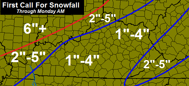
– Locally higher amounts will be possible than what’s shown above.
– As I mentioned… don’t focus so much on the wave of low pressure. It’s the wall of snow behind the arctic front that will deliver the snowfall for most from late Sunday afternoon into Sunday night.
– Wind gusts of 40mph will be possible as the front blows through and that will create blowing snow with whiteout conditions possible at times.
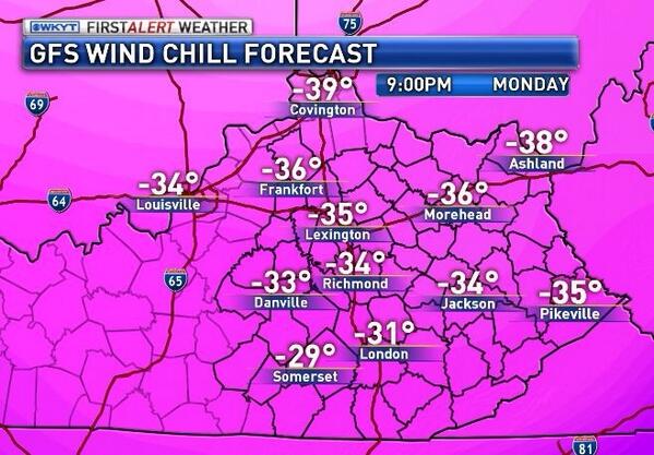
– Thermometer readings will drop to below zero by Monday morning and likely stay there through the day and into Tuesday morning. That’s right… some areas will likely stay below zero for a 24 hour period. I would not be surprised to see a few locations hit double digits below zero at some point… especially in the north.
– Highs winds will continue and that will create insane wind chill temps…
– This setup can produce arctic snow globe flakes through Monday night.
I will have updates throughout the day. The next one likely comes out early this afternoon. Enjoy today’s nice weather and take care.

thanks Chris
This looks to become a memorable time. It has been years since I have seen wind chill reading at -30 or colder. Remember people, keep eye on the elderly, bring pets inside (if applicable), & keep them space heaters away from all flammable items. Most people stocks up on milk, eggs, & bread……never understood the egg part….can’t cook em if you loose power. Me…stock up on bottled water..just in case pipes freeze!
COME ON SNOW!!!!!
http://www.nws.noaa.gov/largemap.php
Hey Kman glad to see your post. Was wondering where you been. I hope we get lots of snow. Been checking the chat room to see if you’ve posted. Hope all is well with you.
Good luck to all of us. This will be my coldest weather ever in my life.
Please don’t let us lose power!
2-5 to the west, 2-5 to the east, 1-4 in central ky? Who’d a thunk it ?
Nasty cold air and very little snow? Why, I am so surprised!!
Sarcasm aside though, this cold is no laughing matter. Today is the day to prepare!
Sure glad most of the bigger snow will be across the ohio river. Keep warm and stay safe everyone 🙂
You should not be, since the lower snow totals especially with ice is far more dangerous for people that have to drive.
Flash-freeze a definite possibility with this one. I think you’re right – in this case more snow would be a blessing.
Which makes the “stay safe” a tad ironic. It should actually be safer with more snow.
But yet road crews scrape the snow and leave the ice
some of you look for any reason to pick on me, kinda tiresome.. but God Bless you
Your persecution complex kicking up again?
Jeff, nobody talking to you, but thanks for your concern.. God Bless
Stop it with your sanctimonious talk.
Amen Jeff. Soundslike sscreeching on a chalkboard.
Im not about anyone, just don’t care for bullies and a men that bully women are very questable humans.. but God bless Jeff, have a wonderful weekend
No, I’m actually with you when it comes to Winter! I would rather have warm temps. Just in this case, an “all or nothing” snow would actually be better than the ankle-biter.
Barb’s posts are like a broken record.
Not sure why my above post messed up and printed like it did. My apologies. I know it’s hard to read.
I have not read many of Barb’s post but there are many broken records on here.
Heck, on some posts you read a positive thought about the snow and you get the obligatory downer post. And they read pretty much the same. Seems to be the reason a lot of people I know that used to come here just give it a quick look and skip any of the comments.
Here we go with the Barb anti snow posts again. Like a broken record..
wow you are one dedicated weather dude! thanks and get some z’s 🙂
This is within an inch for north areas what CB has said all along. The key flow is more a due north east event for the heavier flow and would take a mega shift SE not to be. It is not CBs fault some here listen to Old Skool ramblings and latch on to short term, choice model trends.
This is not likely a big snow for us as a result and CB never implied it. Most of the snow is the wall of precipitation. The part that is a concern is the ice, since that would stay put with the cold air in place. Pure evil driving conditions.
The question is would that be ice first and then the few inches, or is that part of it? If part of it, not bad for weight on structures since only moisture for a few inches of snow. No power with negative temps is some serious trouble, so hoping the ice is part of the snow total factor.
Louisville upgraded to warning and Lexington now under a watch. They expect 2-4 in . for Lexington and surrounding areas. Looks like they are coming around to what Chris us thinking.
NWS out of Louisville is going 3-6 inch possibly more possibly less depending on the time when the rain or mix switches over to snow. This forecast has bust written all over it.
Ice could be the surprise due to the quick transition of cold. NAM looks like it might have been on to something it seems, but based on the mets so far, I think they still are not to locked with this.
Here’s my opinion and this is based on trends and what usually occurs. Temps today wouldn’t shock me to get into the middle 40’s due to the southerly winds it will not feel like middle 40’s due to the winds, but middle 40’s nonetheless. If middle 40’s occur for highs I truly doubt that temps would fall below the mid 30’s due to increasing cloud cover in southerly winds. If the low tracks through Kentucky maybe a tad bit south or over Louisville to me this will be a primarily rain event for most of us. Being that said the models last night trended warmer big surprise there however models tend to do this 24 to 36 hrs before the storm hits. It will be interesting to see what the models say today. Models are still trying to figure out on exactly where the low will track. My best guess would be 60% rain and 40% snow. Key factors here is how far north or south the low goes and how quickly the change over occurs. The quicker the change over the more snow that’s obvious. If the change over happens late morning early afternoon I very much like our chances of a real healthy snow. Just not real convinced that will happen. Its never ever easy. It would be nice just to have a all snow event but that would be too much like right. As far as the possibility of freezing rain it would be really short lived and if it did occur it would happen I would think in western/north central Kentucky during the onset of precipitation but I don’t think temps in my opinion will fall below freezing tonight. How quickly the artic here gets here will be dependent on how the low tracks.
The ice event Thursday was short lived but it cost at least 1 person thier life in knox County. The southerly winds make it feel colder?
Andy, I heard what happen in Knox County difference there was Knox County was at freezing or below. I just don’t believe tonight with approaching cloud cover and southerly winds that most of us will not fall below freezing. Southerly winds can make it feel colder than what it is when temps are in the 30’s and 40’s for highs. Its not like the summer when temps in the 80’s or 90’s with a southerly breeze. You can still have a wind chill in the winter with a southerly breeze. This morning Louisville was 24 degrees with a southerly wind but the wind chill made it still feel like 17. The temp actually rose overnight due to the southerly winds but it still creates a wind chill.
We sat at 14 this am so hopefully we are colder when the precip hits
Depending on the flow, we could see areas during the progression get flash freezing with the wet on the ground and then some ice rain followed by the snow. Whatever snow we do get could look like a snow globe in a blender with the wind.
Timing of the event for what it does and when it happens could be huge. Folks could literally be okay when they leave but be stuck trying to get home.
I agree 100% Bubba
“3-6 inches possibly more, possibly less”. Wow, the NWS is really going out on a limb on that one.
BigPoppaSnow
Time to prepare the flood boats in knox county to be ice breaking boats.
I still don’t think we will get below 0 without a decent snow pack of 4+
I hate having snow totals dependent on when the cold turns rain to snow. That almost always never pans out until later than they forecast and leads to an inch or less. This “wall of snow” behind the front that Chris describes sounds good though!
The “wall of snow” likely turns out to be paper thin.
BigPoppaSnow
Not too surprised about the snow totals either. Probably a heel biter in Sonerset at MAYBE AN INCH. Big story is the cold which is life threatening. Love what you do Chris, just bummed at the TREND as Bubba would say. Snow = nothing to see here, cold= big deal. Oh well.
People tend to not die because it’s cold, or hot, or wet, or dry, or cloudy or sunny….It’s because they do stupid things.
BigPoppaSnow
Waffles anyone….Still hanging on to minor 1-3 accumulations for most of KY. River North thumping……3-8 most of all of Indiana. Snow for KY stinks….Now the cold coming behind this is no laughing matter. Snow pack or not, below zero for 24hrs is no fun. Be safe and THINK SNOW!!!!
The Weather Channel’s winter storm segment plots the path of the low with our storm exactly as the NAM has it. They aren’t even considering the GFS. The difference isn’t much; but the GFS is still farther east.
They IMO have no credibility. They had us at an unlikely 3″to 5″ for the whole state yesterday and now waffle with the NAM. The NAM could be correct, but point being TWC sucks for winter events. Similar to our winter weather results.
Chris, as usual, your thoughts a week out are starting to become reality in the forecast. A decent snow event is a good thing and I hope it gives us more than an inch. That being said, my concern is more for the extreme cold and the chance that the rain is enough to cause power issues. It’s been a long time since we have seen temps forecast to be this brutally cold.
Make sure to have batteries and candles ready as well as knowing where there are extra blankets and such. A portable radio is a good idea as well, in case of power loss. Remember, these smart phones have to be charged to work.
Looking forward to your next update Chris. Thanks for all you do. Right now, gotta get ready to go to work. 🙁
gfs has backed off on the snowfall the last two runs
00z
http://204.2.104.196/gfs/WINTER_GFS0P5_SFC_ACCUM-SNOW_72HR.gif
06z
http://wxcaster4.com/gfs/CONUS2_GFS0P5_SFC_ACCUM-SNOW_72HR.gif
Thats common for the models to waffle 24 to 36 hrs before the storm hits. Today is the day to take the models at face value.
WSW for Wky.
http://Www.armchairmets.com
http://www.weather.gov/
Yep, you guys should be are part of the main action and us folks to the east will get the wake from that in the form of a wall of snow. However thick that wall may actually turn out…
1-4=covering the bases.
well, hoping for bigger snow chances but that’s the way it goes!
prepare for the COLD and THINK SNOW….
Snow good, ice bad!
yes!
I’m still thinking Bell and Harlan Co’s will get around 4-6″. Even with the latest run it’s still shooting out decent totals there.
Ok we mostly stop using the word dome, fence is used, but what about we call us in cky “AGENTS of SHIELD”.
Headquarters is CKY 😉
Well looks like Chris can go ahead and lower most of his snow totals from the looks of it. The 1 – 4 inches for most of ky and easily be changed to widespread 1 – 2 inches with maybe a couple spots lucking out with 3 inches. This ALWAYS happens.. just don’t understand why it’s never applied to forecasts.
The latest NAM looks absolutely terrible. No snow all rain, go figure but sounds about right. LOL
Correction not much snow
This never was predicted to be a big snow maker from the start anyways..The COLD COLD temps is the headliner..Just hope nobody looses power with 40 MPH wind gusts..
Actually there was a lot of talk about this being a pretty decent snow maker in the beginning, just like most of the systems end up being talked about. But, AS USUAL models get warmer, and yet they (the meteorologist) never seem to apply that trick to their forecast which is why people end up becoming upset. But, there are ppl like us on this blog that knows this is going to happen because it does EVERY SINGLE TIME! So, we know what to expect and don’t buy into all the hype. But, yes this system just like all the others was hyped to be a decent snow maker and it’s not going to even be decent. A little snowstorm, nothing to worry about here, just focus on the deadly cold weather!
NWS Paducah is giving 3-7″ for my area. I’m more concerned about the cold than the snow. I hope that those who have to work outside, such as mail carriers, trash collectors, etc, are extremely prepared for the next few days.
Even if we got the snow we wanted, too cold outside for my kiddos to play in it. They are 7 and 4 and still not had a decent snow to sled in.
Any opinions on potential for icing and power outages? I am prepared but so much waffling of mix, snow, combo for central ky and wonder if icing event may occur? Power outages are an obvious major concern with the back end cold coming.
Don’t think ice will be an issue for power outages..Chris said early Sunday may be enough moisture for ice before it starts to warm up..
Thanks!
I’ll take a good ole snow storm coming from the Gulf anytime..Getting one of those anymore is like trying to hit the lottery..Just ain’t gonna happen..
CB just tweeted that the accumulation snow wont happen till late Sunday afternoon and evening. Problem im having with that is most of the real good moisture will probably be gone by then. Maybe a inch or two flash freeze yes heavy snow not here but if your in Indy it will be close to blizzard conditions there. If this was a all snow event this would be epic but 75% of this storm will be???? Yes you guessed it a cold rain. The latest NAM is much stronger with the low and that results in a northerly track unfortunately. Its one model run but I think its got real credibility. The NAM tends to be the better model than the GFS this close to the event.
He also just said most of the moisture is BEHIND the front..he tweeted that directly after what you just said
Do you cold weather experts have tips on how an asthmatic can best do her outdoor chores without going into bronchial spasms? I am kind of freaking out with a farm full of animals and nobody but me to take care of them.
The best answer is don’t, not in those conditions. That’s likely not an option though so wrap your face in scarves or whatever you have handy. Be sure your mouth and nose are covered and you’re breathing through the layers. If we hit the expected -30 plus it’s just not good to be breathing it for extended durations.
Also be sure you’re head is covered well as that’s where most of your heat loss occurs. Basically mummify your head. 😉
KP, our sons have had asthma most of their lives and our pulmonary doctor always told us the best way to prevent an attack in the cold is to make sure their mouths were covered. It’s the cold air that you breathe in that triggers the attack. We always had them wear their face masks – you know, those knit hats/face things that cover the face that you see bank robbers wear in a good thriller on late night tv! LOL! – and then, a scarf, so that if they started feeling breathless, they could pull the scarf up over their mouths for added protection. This worked like a charm for them! They were always able to get out and play and then as older boys, shovel snow for neighbors, etc without asthma problems! It really worked for them! I would really like to encourage you to try this! Good luck! Breathing issues are so difficult at any time, but especially during periods of intense cold. God Bless…
Thank you Chris Braley and Strummer.
I have done as much as I can today to get all the animals to the point that I can dash out to feed and fill the water buckets and then get right back inside.
I have a mask that is made for skiers but it makes my nose run like a faucet. I will wear it and mummify my face, as suggested.
I can also try to hold my breath. 🙂
Thanks again.
Here’s hoping the GFS is on steroids today and gives someone a thumping..
prepare yourself for frozen mud.
I have a funny feeling the NWS will be discontinuing the winter storm warning and watches for most if further model runs show warmer temps with more rain going with advisory level instead.
This looks a lot like what followed the big snow of January, 1978. Yes, in Lexington we got dumped on after being forecast to get 2-4 inches. About a week later we had an arctic front come crashing through. Crazy heavy snow for about an hour, 40 m.p.h. winds, and lightning and thunder. Woke up the next morning and the wind chill was 40 below. It looked like the surface of Mars outside. Nobody went outside. For anything.
Eyewall, I remember that clearly. I’m in Louisville now but at the time I was a freshman at UK. The big snow came on Super Bowl Sunday, I believe. Seems like we had over a foot. A week later came the rain-to-snow arctic front. I was at my girlfriend’s place the evening the front came barreling through. We went from mild with rain to blizzard conditions in a matter of minutes. I went out to sweep the car off so she could drive me back to Haggin Hall. I couldn’t believe all the lightning. We might have gotten 3 or 4 inches with that one, so it was not huge, but extremely impressive to witness.
I was a freshman at UK then also, lived in K-2. I had worked at UK the previous two summers, and in the process became familiar with the network of tunnels under campus that no one knows about. Those tunnels were a lifesaver.
Awesome. Now we are down to 1-4 inches of snow. It never fails. I’m sorry to be negative, but it seem like the snow totals decress with every post.
NWS giving lex 3.5 inches total of sleet and snow. Interesting. Also say it won’t rain until Sunday night haha
One model run shows a thumping and everyone gets in a frenzy, the next run significantly warmer and everyone starts diving off a cliff.
Everyone stay calm. 🙂 Enjoy the ride.
This is a 1-2″ event for Central KY. Precipitation on the back side is always very limited. Another, swing and a miss.
The ball was never Big Snow pitched in the first place by a professional “pitcher”. I think one of them there amateurs threw that ball 😉 It kind of “snowballed” from there.
New run of gfs looks much better!
As in more snow? Lol
Yes …especially the counties boarding the ohio river in north central ky
I’m in greenup county..the most northeastern county in ky..what it’s showing?
There looks to be a large deformation zone setting up from Owensboro to lexington where I think up tp 7 to 9 inches could fall . Everyone should do pretty good though
Frankfort under a winter storm watch but reading some of the comments from bloggers and the NWS this storm could still be all rain or a 6-8 inch thumper!
NOWCASTER folks!
I am going on record someone is getting surprised. The further west the highest chances for a surprise but someone in the state will be real happy
I wish Chris would give is an update.
No tweets or updates. 12z runs must not be too impressive
I thought the new gfs was pretty impressive …he is probably just busy
If you’re looking at the site wintercast.tripod, then that gfs run is still the one from last night. The new runs just came out and I think they are way less impressive than they were.
The new GFS is not impressive at all. Im not real sure whay your seeing???
The new runs of the models just came out and they are trending even warmer, especially the NAM. It looks like there is even less chance for snow. I say everyone in central and eastern ky gets around an inch. If you get more than that then feel really lucky based on what the models are showing now. The cold afterwards however is still going to be a monster. I’ve never witnessed cold like this before.
The gfs looks a lot better tho, Chris said himself the NAM is not a good model
The gfs does not look any better! If anything it looks worse. The NAM is a much better model when it comes down to 48 hours or less before the storm. The NAM takes into consideration how this area typically works. This area, especially the eastern part of the state holds onto warm air longer. The Arctic air will go right through western kentucky, but it takes it usually twice as long for it to take temperatures below freezing on the other half of the state. Usually by that time most of the moisture is gone. I understand there is going to be more moisture on the back side of this system, but with there being rain beforehand I just don’t see it sticking unless it really really snows hard. Which it could, but I’m not holding onto my breathe until it starts to happen.
Michael gotta take this into consideration. Im wondering on how much the models are under playing the intensity and speed of the artic air. Earlier in December the models underplayed the artic air and changed the precip a lot quicker than what was expected soooo thats another concern.
I’m not saying they aren’t downplaying it, but the trend goes with what the models are depicting at this point in time. I hope they’re wrong because I would love some snow. But, i’m very doubtful with this being an overachiever. I will be happy if it snows like crazy for about an hour with high winds because that’s exciting. But, even if it does that the most anyone will get out of that is 2 inches. So, we will just have to wait and see what mother nature decides to throw our way.
NWS has scheduled a conference call at 3:30 this afternoon
Hmm prolly gonna change the forecast to 4 inches of rain lol
CC is for local and statewide responders/stakeholders… I’ll be online.
Growing up in North Dakota I can tell you late in the fall when our artic temps would come in it was always preceded by a solid storm. I have a hard time believing you can get the temps we are forecasted without a solid snow. Have faith people I think this one will surprise you.
That’s why I’m doubting the temps being that cold if we don’t get snow 😉
Agreed. Just saying I’ve got my fingers crossed for you all in KY. We here in Charleston are the Lexington of WV. Everyone around gets big snows and we get minor accumulations but at least we get something. You winter lovers in KY are due. Good luck.
I spend a lot of time in WV during the winter months… elevation, elevation, elevation… My theory… if I were living in WV… I would back my things and move up the turnpike!
Jackson KY NWS planning on issuing a Winter Weather Advisory for Sunday night into Monday..addressing the snow and dangerous cold
….went to bed with visions of 3 – 5 inches and sledding..that felt good…woke up to local mets saying almost NO SNOW for Louisville- rain and flash freezing will be the main thing for most of Ky. What happened?
Because nobody has a clue what is going to happen.
If you were in Vegas and had to bet go with the trend.
FROZEN MUD TOP OFF WITH A QUARTER OF AN INCH OF WHITE FROSTING.
A well none institution here in Ky.
Why is it always so d@#m complicated.
Folks need to also remember how quickly the temps drop with this thing can really affect it. If temps go from 40 to the teens in a matter of hours that can really ramp up the snow amounts. A little moisture goes a long way with that kind of cold.
The latest web briefing from NWS Paducah still given 4-6″ for this area. Of course, for some of our southern counties here, they are now saying they will have to see if the cold air can catch the precip
9 years of experience says…
The trend, the trend, the trend… Trust the trend and history more than the models. So, here’s my prediction:
prediction of snow, followed by cold rain that lasts too long,
radar shows non existing snow,
cold arrives as the moistures runs out,
a few flurries and about 1/4 inch, more north of the KY river,
readers won’t believe the low snow fall amount in Richmond,
someone says they told everyone it was never going to snow
So… BIWYSI and respect Chris for his time and efforts.
The 33 rule gets us even with THESE type of systems. Fear the Fence!
Already 38 degrees in Louisville at the noon hour. I said earlier today temps should hit the mid 40’s and that’s reachable that would be 3 to 5 degrees warmer than forecast.
NAM says SLAM! 😉 …. 🙁
What does it say Bubba?
he is making a joke
Trending warmer, so not a good thing for snow. CB said to disregard last night, but no sure on his stance with that today.
Points to ponder:
1. Why is the NAM, BAM! when it shows good stuff, but not when shows bad stuff? Seems the NAM needs to be factored and perhaps take the average if it’s waffles as part of the equation.
2. Where is Rolo today?
3. CB’s current outlook seems the most logical of the mets (as usual).
4. This has always been a path for a SW to NE flow event with folks to the east SE getting several inches rather than a big event. How did it get built up to something it appeared not to be in the first place? CB sure did not imply it was and has stayed steady.
5. Probably best to NOT go anywhere unless no choice tomorrow night. Just 90 minutes could be the difference from okay to being stuck where you are. Road crews are basically hand-tied to improve conditions when lower than 10 degrees. As Andy said, crews can actually make it more slick when ice is at the bottom in colder air.
I am not going to pretend to know what will happen tomorrow other than siding with the “T” word. Still seems uncanny that regardless of if east or west, Richmond/Berea seems to always be the first areas cutoff from the winter storm maps. Uncanny!
Item 4 is best case, several inches. Ankle biter = 2″ to 3″ and toe biter = 1″ or less.
You know, perhaps “they” should work on the models to where the gfs is useful more then 24 hours out.
Imagine being CB and having to deal with this stuff.
I thought it was Nelson Co/Bardstown….they just issued the new WSW and as always, one county away from us to the north….well, still in the watch area, but isn’t that the norm? I see a repeat of Dec 22, ’04 here….we get all rain then turn into an iced-up mess, while everyone to the north of me by around 10-20 miles gets the buttload of snow….such is life on the fence!
Sometimes I wonder why none of us get paid..we are pretty good “nowcasters” ourselves lol
Weather Channel is showing 3-5 now but can’t read much into that. Just think as I posted last night will not no much till late this afternoon or this evening on this one. I for once will not be surprised if the totals get increased despite the morning model runs. Time will tell! WW
PS…Fight Eagles Fight!
CB tweeted a 5 degree temperature difference for KY (some zero and some -5). This could correlate to an expectation of less snow the more SE you go from the main flow of the event. Guess that is obvious…
15 he tweeted -10 to 5 above
NAM intervention? Appears that is a bigger temp spread compared to what was expected. Seems the snow map would need to be revised if the correlation of temps tied to the snow on the ground.
Anyone know where you can get online to view comments for Louisville NWS discussion at 3:30pm today. I know sometimes wave3.com will have it but, not sure they will today since it is the weekend?
eric, Ryan Hoke is going to have a live blog with the call on the wave3 wx blog.
Based on the noaa precip type….Meade County can still be on watch for 4 inches by 7 PM tomorrow. I hope this is right!
im here bubba, been buried up all night. BEEn capping hordes all morning.
still seeing 6 plus for central/SE KY/e. the NAM best model 24 hours out usually so watch next run of nam.
Though I love it when you are the Rolocoaster, I like your gumption sticking to it this time! 🙂
the NAM isd ur 24 hour out model folksd. go with NAM run rest of way
weather channel uses THE GFS American model for their forcast.
“Winter takes a break for a week…”, partial vindication of Blowtorch. 😉
Winter’s over folks. This was our once a decade chance for snow & now that’s 100% gone. We might not even get a COLD RAIN out of this……
The BLOW TORCH lives!! All should now denuflect & show proper respect to the BLOW TORCH!!
BigPoppaSnow
12z GFS
http://204.2.104.196/gfs/WINTER_GFS0P5_SFC_ACCUM-SNOW_72HR.gif
well looks like another bust according to the gfs
12z NAM
http://wxcaster.com/gis-snow-overlays.php3?STATIONID=LVX
http://wxcaster.com/gis-snow-overlays.php3?STATIONID=JKL
I just love the way the NAM finds Louisville and drops no accumulation. How fitting and predictable.
Because the NAM somehow goes with Trend of how things works out around these parts. I’ve been trying to tell people this.. lol. This is not going to amount to much of anything at all snow wise!
50 miles gets you from an inch to 8 inches….
After watching so many forecasts bust over the last 20 years, one of my rules is to basically discount any forecast that is predicated on rain changing to snow and then accumulating. It just never works out because the warm never dislodges as quickly as the forecasts suggests.
I live in Louisville and I’ve seen this before. It will definitely snow at the tail end of this event, but I’d be surprised if the initial push of moisture accumulates to more than an inch. I don’t think the WSW will be discontinued, mainly because of the cold, but I think it’s unlikely Louisville ever meet the warning criteria.
You are exactly right. I live just outside Louisville and I’ve seen this 100 times before. It always stays rain a few hours longer than expected and we always end up with an inch or two of snow. Southern Indiana always gets the most, Louisville a few inches less, and just 20 miles east in Shelbyville we always end up with an inch or two less than Louisville. Most of the time in these rain to snow situations the weather forecast is wrong.
I remember in the early 80’s, in southeastern KY, when I was in high school, the temp dipping down -20, and remember the arctic snowflakes in the air, not a cloud in the clear night sky but yet tiny flakes of snow were falling, I believe the the air is so cold that it wrings out all available moisture in the atmosphere. A very cool thing to see and experience.
The afternoon run of the models should tell the story for central KY, WSW will probably downgrade to a advisory level for impacts vs high snow totals!
Chris, I need a fix.
This is probably a case of ignorance is bliss 😉 A 15 degree temp spread would seem to mean a bigger difference in snow fall and probably a more N, NE flow. The snow wall might be very thin, the further SE you go.
That is enough conjecture for one day. My guess is the “T” word wins and more likely one of Rolo’s goats wins “The Voice” than us seeing much snow. Not just auditioning- winning too.
Dodger says underachiever! 🙁
Wave3 weather out of Louisville saying this a definite NOWcast weather situation, large model jumping is normal with this type of storm so throw out all models and NOWcast the storm as it comes in!
Not my words but theirs!
That NAM map someone posted even has Dayton getting a couple of inches.
Good reason to throw out that model, the forecast their is for atleast 8 inches of snow!
Doubtful on that. I think a lot of ppl are going to be shocked at how right the NAM model will be with this event. 😉
Just looked at Dayton forecast 8 to 12 inches!
I wouldn’t be shocked at this point to see mid 50’s for highs tomorrow with thunderstorms. And the low become a lake cutter.
The ground is still frozen solid at my house amd I think that will cause problems if it doesnt start warming up
Euro 48hr Snowfall
http://forums.accuweather.com/index.php?act=attach&type=post&id=218010
Wow, talk about a Benedict Arnold! It went from the aspired beacon for KY chances days ago to another model trending bad. At this rate, even cherry picking models that look the best will be hard.
Goes into agreement with the NAM model.
and the GFS! idky they’re saying there is no agreement, there is plenty of agreement. They hyped this thing into something, and as usual it’s not going to happen. They need to just hurry up and admit it and take away the winter storm warnings and start talking about the cold weather!
I know! Even places like Pittsbrg,Columbus will get hardly anything based on that.
Which begs the question….Why even put these models up a week out if you know they’re going to be WRONG? We’ll know what it’s going to do about 5 minutes after it’s over, same as the Weather Gods.
When did the term “nowcasting” pop up? What a great excuse word to use when trying to cover your butt.
Man, I wish I could use a term like this in my business. In other words, “Hey, I’ve kinda given it a shot and looked over some stuff, but I gotta be honest- I have no idea what is going on and you will just have to wait until it happens for me to tell you what is happening. Get it?”
I’m with you Tominlou…see my reply just above your post.
BigPoppaSnow
swing lowwwwwwwwwwwwwwwwwwwwwwww sweet CHARIOT,,,,,,,,,,,,, THE SNOWDOME a COMIN TO TAKE U HOMEEE…
still see 4-6 inches for SE KY. tonites runs flip back to what GFS and NAM was showing last nite..
I don’t understand why the NWS in Louisville would upgrade Louisville to a winter storm warning? It makes them look foolish if they cancel it in the afternoon update. They were predicting 3-6″ of snow and all the local mets saying 1-3″ at best. Usually local mets copy and paste straight from the NWS.
you have some bad mets then LoL
All hyped up and no snow to go. Looks like an inch or less in and around the metro. If you want snow, move to central IN. They are in the sweet spot this winter.
There in the sweet spot every winter
Exactly. Indiana always gets all of the snow. We are on the wrong side of the river.
Snow or no snow I’m more worried about these anticipated dangerously low windchill forecasts for Monday into Tuesday morning! I don’t think this is a situation that can be over-hyped at this point because that type of temperature can cause damage to the human body very quickly! Remember to check on elderly and disabled neighbors if you have any close by and make sure to prepare! Unfortunately this will definitely not be a situation to go out an play in the snow even if it does fall.
Then don’t go outside naked! Wind chill has nothing to do with structures & vehicles….NOTHING other than exposed skin. But, if you’re silly enough to go outside in 30 MPH winds with the temperature at ZERO, then maybe we need to thin the gene pool a little.
BigPoppaSnow
Wow… pretty sure that response was uncalled for. I’m a teacher and employee of an agency that works closely with the ‘at risk’ community. Wind chill may have nothing to do with structures and vehicles but it has a lot to do with the people INSIDE them and when those individuals live in homes that aren’t properly insulated and don’t have good heat or heat at all, then it can affect them very badly. Even lead to death. So yeah… tell me again how it has no affect on anything other than “Exposed skin”.
One run of the models and you people freak out, everyone take a deep breath and relax, I’ve been around long enough to know that most every extreme snow event in KY has never been predicted by a computer model!
FACT not Fiction 😉
Agree I say SURPRISES coming
We can wish for all the snow in the world in our hearts.
But we do have brains and we no the trend and the evidence that all the decent weather models are presenting.
With that said I will not give up until I see all 3 models at the 00z time.
If this result ends like the past results I say bring on the BLOWTORCH.
Cold air with no snow equals Iceland.
Take a look at all the warnings and watches they will be replaced by advisory’s here real soon.
I’m calling all rain for louy metro.
Louisville Metro still in the hunt for a shift, but currently in the 2-4″ forecast at this time.
WWA’s out for Louisville and Lexington.
Received my notification @ 1428.
2-4″ north of a line from Greensburg to Liberty… 1-3″ south of that line. Impact start time around 1800…
The wind sure is blowing things around right now in downtown Lexington…
Snow totals 2-4″ sounds realistic for Louisville.
I still expect potential double-digit snow amounts from Bloomington to Indy.
I’ll be using RPM model for nowcasting. I’ll be looking at it within 12-18 hours of expected changeover. Also, surrounding weather offices as to their precipitation types.
This still has potential to overachieve.
Sils?
Mike you work at the nws in louisville right ? …or im I thinking of the wrong person??