Good afternoon, winter weather weenies. The pattern continues to head into the extreme as we roll toward late Sunday into early next week. A dangerous blast of arctic air will dive in here Sunday night and will be preceded by a nasty band of snow.
I really don’t have very many changes to my overall thoughts on how this all plays out. As always, a few issues will have to be cleaned up as we get closer. Let’s break it down…
– As I’ve been saying for a few days… this isn’t about the track of the low pressure. It’s all about the band of heavy snow that swings in behind the arctic front.
– Temps today or ahead of the arctic front have no real influence on what happens BEHIND the front.
– The front will be pushing across western Kentucky Sunday morning and won’t reach the east until the evening hours. Accumulating snow for most areas won’t take place until late in the afternoon into Sunday night. Don’t freak out when the sun is out and it’s in the 40s in front of the front. 🙂
– This snow band will be on the nose of the arctic air diving in from the northwest. There looks to be plenty of lift to get the snows to crank up. Gusty winds of 40mph will blow the snow around and may create whiteout conditions at times.
– This still looks like a general 1″-4″ across the state. Higher amounts will be possible in the far west and far north near Covington. I can also see some higher totals along the Virginia border counties. I made a new call for snowfall map and just realized I saved over it and I’m too lazy to go back and redo it. 🙂 How’s that for honesty?
– Temps will CRASH from west to east behind the front. With the wet roads from showers ahead of the front… a flash freeze of roads will be likely. Throw snow on top of that and significant travel problems will be likely Sunday evening and night. This is another HIGH IMPACT travel event.
– Temps drop below zero by Monday morning and likely stay there through the day and into Tuesday morning…
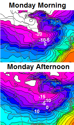
– Those numbers are BRUTAL and record lows are in jeopardy for both Monday and Tuesday. Wind chills will make this an even more dangerous situation than what it already is. Wind chill numbers of -30 will be possible Monday and Tuesday. Those types of wind chills are RARE here and have only occurred on a limited number of occasions in the modern era of record keeping.
– RESPECT THE COLD! Take all necessary precautions to protect life and property before the blast arrives.
– Longer range… an overrunning snow and ice system is very possible by Thursday. Winter takes about a 5-7 day break after that, but it comes roaring back after that. I don’t think this is the last time the Polar Vortex impacts our weather.
I will have more updates later in the day and will have a final call for snowfall later tonight. Again… most of your snow won’t arrive until late Sunday into Sunday night.
Enjoy the rest of the day and take care.

?
NWS just replaced the watch and warning with an advisory. Saying 2-4 for Lex. area.
I’ll take 2-4 inches!!
thank you Chris. there’s always a chance….I’m holding out hope for a decent little snow.
on another note, Drew Barker looking good in the all star game.
GO CATS!!!
Any word on M. Elam?
Tide or Cats?!?
Elam was supposed to pick during the game. he changed his mind this AM- announcing 2/5- national signing day…..
Got it! Thanks… at least UK is in the running… it has to be a tough decision…
Thanks Chris for giving me and all the other readers a chance to calm down.
It is the lull before the storm.
I am not greedy I like to see a 2-3 in. snowfall across the state.
I hope we have plenty of gulf moisture when the cold front comes traveling thru.
I can’t imagine the sorrow rolo is feeling after seeing the 18z NAM… poor boy.
I still do not know what Rolo was seeing to go Old School in the first place, but nice to see him not waffle. He held firm!
I quess all we need to do now is be prepared for the cold air.
Thanks for the update CB…New it wasn’t going to be a big deal as you would have posted earlier if you thought things shifted in our favor….JUST SAYING…
We all need to pray for the freak storm. Other wise a general dusting to one inch after some cold rain.
Like I said earlier the NWS in Louisville is a joke.
no more so than the jackson NWS. lol
Surly the advisory is for the temps being so low and not for the snow. I have to laugh when we get these advisories or threat for four inches of snow.
Thanks Chris. Know you are going to be busy with this so I will say it in advance. Be safe, everyone, and don’t forget the elderly and those pets! Make preparations for them as well.
Yeah, I worry at times like this. My mother, in her 70’s, lives in Bath county. With the rain, flash freeze, and then snow and bitter cold she would be in trouble. I do not currently have a 4×4 and those do not go well on snow anyway. And she thinks it will be fine and will not come hear where I have the generator and stuff. And a little more of the freeze and a little more snow, like the high end at 4 inches would be tough.
Thanks Chris. Looks like this is a pretty big deal if we get that flash freezing and that 1-4 inches of snow with those temperatures. Would make it hard to keep the roads clean. Especially for areas that get in on some heavier snow. Not liking the sound of the snow/ice late week either. Especially if this stuff lingers around. Seems like schools here may be getting an extended Christmas break.
I wonder with the wind, considering the ground here is wet already, combined with the rain and the quick freeze and snow will cause power issues. I worry for peoples safety if they need to travel to find a warm place. Hope everyone stays safe.
2 inches of snow is enough for radiational cooling to push the temps lower.
Not as dry as it is it wont be
All you down players out their I challenge you to go driving tommorrow night in 3 inches of snow and 40mph wind gust and say this isn’t extreme, this going to be wild winter weather, maybe not the 8 inches or more everyone would love but nasty as it gets for KY winter weather!
Yeah, but as it happens the snow goes from 8 – 3 – 0. Wouldn’t bother me to drive in it, the wind chill doesn’t do a thing to the vehicle. I’d be nice & warm inside.
BigPoppaSnow
Your counting on no moisture behind the arctic front, that is not the current forecast??
But it will be by the time of the “Nowcast”…..
BigPoppaSnow
Is that all you got lol
Yeah, and he did mention the flash freeze so that would put ice under that snow. 3 inches of snow with ice under it will be dangerous. If it does rain and flash freeze we may be lucky not to have 8 inches of snow. I would really like the snow but that kind of setup would be deadly with the possibility of power outages and temps so could they may not be able to work (or at least no very efficiently) on getting it repaired.
Did you really think that we were ever going to get in on this snow event?same ol song and dance, our friends to Covington north louisville west and the mountains of se ky get the the snow as we cursed ones get rain ,sleet and a inch of snow maybe… Again.
Don’t add Lou. in those number. 1-2 inches at best for the metro…Travel across Ohio River about six to 15 miles and meet thumper….5-8 inches…Crazy as it sounds, but has happened numerous times over the course of the past 15-20 years.
figures the storm system would take the track that everyone said was the LEAST likely to take.,
Track is still on across Central Ky exiting to the east. Cold air does not catch the precip. soon enough to turn to snow. Going to be 1/2 inch of COLD RAIN Before changing over to snow. The track just never shifted to the South/East as it never does with this type set up. Would not be surprised if it does shift North/West and give us even lower snow totals and more rain.
I think the rain before the snow and cold air is a bad thing cause it will wash all the pre treating of the roads away….After the snow comes all the cold air and the salt and chemicals to treat the roads don’t work very good at those temps….Just my two cents……
It’s a bad thing due to flash freezing.
there probably won’t be any pretreating due to the amount of salt still on the roads
LOL…Isn’t that the truth….But it will also be washed away by the 1/2 inch of rain. Now refer to post above…
Be hard pressed for half inch of rain
I agree, I think it may happen SO fast that there will be a lot of accidents 🙁
Still wild how it does not matter how cold or how extreme. We stopped getting big events 16 years ago in CKY. Average two year gap between events since the 70s has turned to 800% more so far.
Fear the Fence!
Dark Side!
Dead on BubbaG, dead on….You are the man!
BigPoppaSnow
Depends on where you are in Central KY. Louisville got almost a foot of snow in March 2008–I got 8 inches in Lawrenceburg, and I am squarely in Central KY. Do you not consider 8-12 inches a big event? I’ve also had two five-inch events since then.
Referring to Lexington, Richmond, Berea and Winchester areas near. The megalopolis of the center!
Heck, Georgetown has had a few bigger snows in since 98. So close, but yet so far. If I did not have to drive this evening, I would drink a toast to the ghost of big snow past!
Correction Woodford County has been and always will be epicenter of the dome. Not sure how Anderson county gets all the 5 in hers but they are on the other side of the river.
I have a friend that lives right on the river at the end of Clifton Road in Woodford County. It might be 5 miles from me–takes 30 minutes to get there, but about 5 miles. Many times we have had more snow, but also worse severe weather. I do think the river plays a factor.
Waiting on the NWS CC to begin…
Their will be a southeast shift in the models tonight right it down!
Weeeeeeeeeeeee!
Sorry Rolo, I’m stealing your thunder 😉
Now is the time Rolo would be hollering “Bust!”, but he is holding firm for the first time. I miss the Rolocoaster, since that is all there really was. A little comic joy amongst the lack of big snow, or for that matter a middlin’ snow.
Since the lakes in the north are frozen or about to be, even our frozen fin friend Clipper can not grace us with winter jolly.
It is SO BEAUTIFUL today! Just saying….enjoy the few hours of calm sunshine we have left. Still trying to figure out what a “wall of snow” and -30 degree wind chills will be like.
Move to International Falls and you can feel it every winter. Not going to happen here. Friend of mine just returned from Ice Fishing last week. 36 below with 56 below wind chill. He said it is no fun.
Ice under even an inch of snow with zero temps makes for worse driving conditions that six inches of snow at 30 degrees any day. I think the advisory is warranted. Also if we go past -7, it will be the coldest temp since 1996. If anything, I would think this event will be the most significant in several year.
Thanks Chris, you seem level headed on here with useful facts instead of off the wall chatter.
Been reading the NWS out of Louisville saying the confidence level in snow amounts is low at this time.
Their saying the colder air might arrive faster than models are showing!
Then why is their confidence lower? Oh yeah, the 33 degree rule. Got it! 😉
Told ya
Winner Winner Chicken dinner
Ask the NWS its their discussion 😉
What would be the effects of the cold arriving faster?
Seems like they think that is a possibility. They say they are confident in the precipitation but they think the models may be a little to slow with the cold.
More snow is my take! Just look at the national radar, the low coming in from the southwest isn’t even showing yet!
Todd–what is the current temp in Frankfort? I’m showing 28 here in Lawrencburg-quite a bit cooler than forecast. Even if the clouds thicken up I can’t see it reaching 40 tomorrow.
I am wondering abt church tomorrow eve in Greenup Co, if we should call in eve service or not, don’t want those temps to crash and get slick while in church and then have our elderly trying to get home in that!!
Better idea in the morning. That seems close to the change.
thank you!
Snow is not the big deal here in Somerset , it’s like Yukon Cornelius in “Rudolph the Red Nosed Reindeer”. He keeps hollering There’s Gold!! There’s Gold!! His ice pick hits the snow and he tastes it then says “nothin’!” That’s our cry with the models. “There’s snow!! There’s snow!!” Then like Yukon and his gold, it’s us and snow fulfillment, “nothin'”
I don’t even think I will check the weather for the rest of the winter. It brings nothing but disappointment when a “big storm” is supposed to hit and then nothing happens.
What big storm? Chris said two days ago 1-4 inches, that is still the forecast!
Many people were looking at the Southward trend yesterday from the beloved models(lol), and thought maybe this could turnout to be a superstorm.
I know Chris stuck to his guns,but other news networks was warning us about the winter watches & warnings.
The Who said it best “WE DO NOT GET FOOLED AGAIN”
I did not see anybody mention big snow for us, but did for the areas currently under a watch. Some folks cherry picked models that looked good and dissed the ones that looked bad, but seems it was mainly non mets.
Maybe folks selectively chose what they wanted and filtered out northern, western, Louisville, etc and just generically took it as Kentucky?
BTW, I am just messing with Rolo. Tomorrow has not happened yet, so there there are no absolutes either.
You will need to take that up with our friend Rolo. He apparently got some in the blog in a big snow fevah! Like all fevers, they are driven partially by hallucinatory perception 🙂
CB never implied big snow.
That said, we need to spin tomorrow’s event with something a politician would do, with no big snow:
Snownado!
Snowicane!
Hurrisnow!
Snownami!
Great White Wall of Snow!
If it ends up being mainly just a lighter event:
Snowglobe in a blender!
Flurries of Fury!
Super Sub Zero Snow!
See?! 🙂
POLAR VORTEX!
http://i.imgur.com/3Cynv9u.png
Sharknado
Shark-nado
love love love it Bubba G 😀
U r not lazy chris bailey!! Lol u r over worked and I imagine quite exhausted. 🙂
Go back about 4 days and read it again.
Yea – it’s a good thing he said for people not to freak out tomorrow when it’s in the 40s and raining……Had he not mentioned that in this latest post, can you imagine the comments tomorrow?
Oh there will still be negative comments. People use the topics section as their own personal therapist.
The only way one negative comment should be said is if it ends up all rain no snow for the entire state. CB has held firm on his 1-4 with high winds. He did show some very tempting models a few days ago, but he and most everyone on here knows that they are just eye candy. He knows the trends of Kentucky snows and will always have us prepared no matter the weather.
That won’t stop the boneheaded comments from coming, unfortunately.
I’d much rather have a few inches of snow and about 30 degrees than a little bit of snow over ice! This could be a very dangerous situation. Thank you Chris for all you do for us.
Get the hot chocolate ready folks! I’ll be filling containers with water tomorrow in case my water lines freeze. Gotta have water for coffee and hot chocolate. LOL Bernie, where are you? I miss you posting on here friend.
I bet most places will see a couple inches of snow…the TEMPS are what we should be talking about here…-30 wind chill..WOW! that is dangerously cold! I hope everyone stays warm, remember bring pets in and check on the elderly and keep the faucets dripping to prevent pipes busting!
to be honest everybody that post on here from time to time is negative.
and considering the situation there is nothing wrong being negative at times.
the only person I know that is always sweet is the coffeelady.
You left out Barb.
don’t bash barb….
God bless 🙂
Umm no
That is the absolute truth….Coffeelady is always as polite as can be. But KY winters are SOOOOO frustrating that it is hard not to be negative at times.
I’m ready for the big one!
Low today was 13 and high 41 in Lawrenceburg. Already down to 33. The ground is still frozen. I tried to pull some Christmas decorations out of the yard today–my mistake. I’m wondering if the cold ground will play havoc with the weather tomorrow? And, forecast low was 32. Seems like that might be optimistic?
Agreed
Love to follow your forecast is there anyway you can give the Bowling Green area a little bit more of what is on our way ???
The GFS is terrible. The ECMWF wins again. Hoping Nashville can get a decent ankle biter but who knows. Sure hoping the 1-2″ can verify for us!
How can you honestly say which model wins more than 24 hours from the start of the event???
Keep the faith, folks. Remember, we haven’t seen arctic air of this magnitude for nearly 20 years. Does anyone really think the models are handling it well? It could change rain to snow faster than the models are saying.
A very good point you have. I will hope for the best.
Great point! The models might be having trouble figuring out this record cold.
Thanks Chris, I have been reading every post as I always do, and I am hoping for the best, but preparing for the worst. I will let you guys know when the ugly arrives here in Barren County. I will be watching what goes on at home in Bourbon County too, as my Mom lives in Paris.
Id say the warmest place for us to be during this would be the same room as the servers for this website. 🙂
Thanks Chris, I have been reading every post as I always do, and I am hoping for the best, but preparing for the worst. I will let you guys know when the ugly arrives here in Barren County. I will be watching what goes on at home in Bourbon County too, as my Mom lives in Paris.
I’m less worried about how much or little snow we get than the cold temps! Remember to leave your water dripping a little for the next few days to keep your pipes from freezing up, starting tomorrow night.
I am in Scioto County, we along with Lewis Cty KY have a Wind Chill Warning starting at 4am on Monday. I’m majorly confused to why Lawrence County Ohio and Greenup County Ohio only have a Wind Chill Watch-and it doesn’t start until 7pm on Monday. I can see Greenup from my house windows. I know that its not going to take until Monday night for them to get as cold as we are. Our weather is always the same-barring an occasional thunderstorm that may reach the southern parts of Greenup or some snow-but the temps have never been that widespread different.
?? Why does kyt website have high 36 for Sunday.. Chris says 40’s.
I was just wondering what bengals football weather will be tomorrow. Any chance they play in some snow after halftime????
You will likely see snow in the second half.
Snow on the ground will keep your water lines from freezing outside so the more of that the better. If you have all the vents closed of under your crawl spaces, heat pump duct work underneath floor, and pipes are wrapped with insulation they should be okay. I was under mine earlier today and was warm as toast. What I am worried about is the electricity going out because the equipment may not be able to handle the cold.
I have a question for everyone. If you have a heat pump and the temps go below zero are you switching to emergency heat or letting it run?
Most heat pump will automatically switch to emergency heat if there is about a 5 degree temp between the tempe in the house and what the thermostat is set at ..Example if your thermostat is set at 72 and the temp in the house gets down to around 67 it should switch to emergency heat to pacify the thermostat………..
Let it run. You should have auxiliary heat strips kick on automatically to help your heat pump out when it is really cold. Emergency heating is only for use when your heat pump is malfunctioning.
Now down to 29! I’m getting more concerned about a freezing rain event in the morning.
Chris where you located?
Lawrenceburg, KY. About 45 miles East of Louisville and 25 miles West of Lexington–just South of 64 and North of the BG
Are temps supposed to rise overnight? If not, would think you’d get some frozen precip at that temp.
The forecast low from the NWS is 32. Now down to 28! They might rise–but I’ve seen rain freeze on contact even with temps slightly above freezing given a frozen ground. It was 1 above zero yesterday morning–I would say the ground is going to be frozen for quite awhile. I think the precip will switch over to rain tomorrow afternoon but I am concerned anything that falls tomorrow morning will create a travel nightmare. I’m planning on staying home.
I’m down to 28 degrees here near Seneca Park. Lot of green space near me so I’m usually a bit cooler than most of the metro. I still have snow on the ground where the sun never hit and my back yard, which sees very little sun in the winter, is still frozen solid.
Temps are dropping quicker than what I thought. Dew points are very low statewide winds have slacken off considerably, cloud cover hasn’t reach the Commonwealth so unless im missing something there should be no reason for raditional cooling not to continue until cloud deck gets to the Commonwealth. Very strange temps went warmer today than what models projected and dropping cooler this evening than what models were forecasting.
I noticed clouds increasing on the northern horizon. I honestly have no idea what is going to happen tomorrow but I just suspect that the models do not have a good handle on this situation. It’s going to be an interesting day tomorrow.
To be quite honest I hope the cloud cover deck doesn’t make it here to the wee hours of the morning to allow max raditional cooling wouldn’t that be something low 20’s and then clouds and precip rolls on in lol
I agree. I’m sitting at 28, and I thought that was low, but the observation out of Frankfort showed 28 at 7:00. Those airport temps in Louisville/Lexington always are too warm.
Not to worried about the snow.That will come and go quickly but I am concerned about the temps and the wind chills.We had temps like this back in the 60s but we have gone so long with warmer temps I really hope people will take them seriously.Seems we will be 48 hours or more with very cold below freezing temps.This can cause a lot of problems.
Wife secured the outdoor feral cats as best she could earlier today.Please try to get the pets to a warm place if at all possible and don’t forget to check on the elderly.
Louisville NWS just dropped accumulations to an inch or less nothing to see here folks
Really? Here is what I just read. “The onset of more significant winter weather still looks like it
will be in the afternoon/evening, early across the northwest and
later in the east. A quick rework of the forecast gives similar
storm total snow numbers in the warning area, 4-6″, and 1-4″
elsewhere. Thus no changes are needed to those warning/advisory
headlines.”
I just got this alert on my phone
Sunday: Rain before 4pm, then rain and snow. High near 39. South wind 7 to 11 mph becoming southwest in the afternoon. Winds could gust as high as 23 mph. Chance of precipitation is 100%. New snow accumulation of less than one inch possible.
Sunday Night: Snow, mainly before 1am. Low around -2. Wind chill values as low as -15. Blustery, with a northwest wind 15 to 21 mph, with gusts as high as 30 mph. Chance of precipitation is 100%. New snow accumulation of around an inch possible.
That’s a direct quote of LMK’s forecast discussion from 7:15 tonight. Not sure why you would post something that isn’t true? We may indeed get an inch or less but the Louisville weather office didn’t say that–unless I read the wrong forecast discussion.
again nothing to see here folks
Darren what weather app alert do you have? Get rid of it its really inaccurate
Ummmmm no they havent
Losing!!!!!!!!!!!!!!!!!!!!!
Im not sure what Darren got that inaccurate info
Copy and pasted from thier 7:19 update
The onset of more significant winter weather still looks like it will be in the afternoon/evening, early across the northwest and later in the east. A quick rework of the forecast gives similar storm total snow numbers in the warning area, 4-6″, and 1-4″ elsewhere. Thus no changes are needed to those warning/advisory headlines.
The cloud cover was suppose to be here hours ago it is not NWS says temps should not drop to much more because of the southerly winds. I would buy into that if the winds did not go calm which they have. So until the winds pickup raditional cooling I think will continue to occur. The models are wrong so far with the cloud cover.
Somebody needs to go back under the bridge
I will.
LoL if you thought I meant you sorry Mr Mercer
I didn’t. Just wanted to provide a laugh or two.
Whatever the models models are doing, CB 101:
If the events sends to be getting stronger, he will tweet or update.
If no change, might be awhile.
If getting weaker, he will review the models and verify with more rubs and then post later.
Good news is naturally more expedient than bad news.
Seems not sends
runs not rubs.
Funny spell checks.
When was the last time there have been 4+ consecutive posts of CB with 100+ comments on them? That’s a lot!
33 degrees in Louisville temps have dropped 8 degrees in 3 hours raditional cooling at its best, models are way off temp and cloud wise. Suppose to be cloudy and not near freezing but it is. Ky mesonet has temps already in some county’s in the 20’s and lower 30’s at this hour.