Good evening, gang. To show you just how widespread this extreme winter weather is.. take a look at how much of the country is currently under some type of warning or advisory…
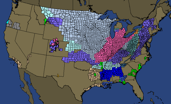
Those will likely expand farther east and south over the next couple of days. Here’s a closer look at the bluegrass state…
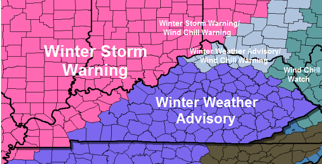
Wind Chill Warnings will likely be issued for the entire region for Monday and Tuesday. Wind chills approaching -30 with readings below zero will make for a life-threatening situation.
The band of heavy snow behind the arctic front tomorrow evening into the overnight still means business and will combine with a flash freeze to produce traffic nightmares.
While the cold on Monday will be dangerous… something neat is going to happen. You are going to see it snow with temperatures below zero. There is a lot of low-level moisture and I think we see rounds of flurries and snow showers with some light accumulations. The snowflakes will be much different from the ones we normally see around here because of the bitter cold.
Basically… it’s the north pole around here Monday and Tuesday.
Take care.

Ready for a SURPRISE
Can someone explain to me why NWS is giving 1-3 inches of snow in Eton, Ga? And we are getting an “ankle biter”?
1-3 is an ankle biter I thought
Andy Rose, I was just thinking if someone that far south of us is getting 1-3, shouldn’t we expect more?
Theoretically, however, in the last 2-3 years Southern Texas, Louisiana and Alabama, for instance, have gotten larger single snowfalls than we here in Kentucky in 10 years or longer. If you love snow, Kentucky is not your friend….you must go north of far south.
Yep. 1 is a toe biter and 2 to 3 is an ankle biter.
I would have to think we will get more than Georgia since the further north you go in Kentucky and Indiana, the higher the snow totals are forecasted to be. I really have a feeling, like someone stated yesterday on here,that this will be a surprise on the high end of the forcasted snow totals. I believe CB is just being cautious and not overstating the higher total possibility based on the trend. A little reverse psychology so to speak,so when we get more than the forecasted amount of snow,all of us snow lovers(Barb excluded),will be as happy as child on Christmas morning…..
Loving all the updates. Hoping to see some nice snow; however, My husband is a lineman and I WORRY about the possibility of him having to work out on this extreme cold. Stay safe everyone!!!
Linemen rock!
Yes, they do, especially mine! Lol
My last comment of the night. Still sitting at 28 in Lawrenceburg. I wouldn’t underestimate this system. In 1989 we had 4 inches or less of snow and dropped to -19. Same deal in January of ’85. I think the real story here is the cold.
We were at 28 in Shelbyville 2 hours ago but now it is 34 at my house!
I find it fascinating that a river (and one not that wide at Louisville) is the difference between a warning and an advisory. And Dawnp007 a toast to your husband; linemen deserve a lotof gratitude.
Thank you!!!
Dropped 7 degrees this past hour in Louisville, by the way.
I noticed that too! Was it supposed to happen that dramatically this soon?
I’m so confused at this point, LOL.
You and me both lol!
I HATE winter, dry nasty cold air…Please give me sunny, warm and 80 degrees all year long…
Go Steelers…
Florida is calling. 😉
Family in Florida says its been cold and supposed to be near if not freezing in FL. I have seen it snow in central FL so….
Sure wish I was there though lol!
Vinny!!!!
Move to Hawaii, record low for the state is around 50 and the record high is in the upper 90’s…80’s for highs everyday!
NWS Louisville… Low Saturday night 34F. Current temp at SDF (7:56 p.m.) 33F.
33 degrees and thats taken at the biasly warm SDF so the burbs of Louisville are colder than that.
Bigger question here is temps are taking thanks to raditional cooling no cloud cover as of yet. Models claim that we should be cloudy hours ago and temps should not be hovering near freezing dewpoints are low so until the cloud cover arrives or southerly breezes kick in temps should continue to drop.
Seems as though our storm is holding back a bit. Does this mean it cuts more to the northeast; or does the polar plunge catch up to it?
Polar would catch up to it its on the move its heavy and dense
Bowling Green is 31F; but to be fair, Huntingburg, IN is 39F, Owensboro is 38F, and Paducah is 43F. The latter three are in the warning area.
The polar air looks like it is catching up to the moisture. Good for us snow lovers.
Still 37 degrees in the East Bernstadt area.
Was 37 in Lexington and same right now in Richmond.
It had gotten back down to 30 a few hrs ago now its back up to 34 according to mesonet for knox
34 now in the might city of Richmond.
Warm air advection has commenced…went from 28 to 32 in last 1/2 hour per my readings. Bit much to believe (sensor may be flawed) but telling nonetheless.
when do the next models come out?
NAM after 9 and the GFS around 10 or so.
NAM just started its run!
Yes the southerly winds I noticed have kicked in. But by this time tomorrow night everything should be in the process of freezing solid.
At 8:30 PM ET practically all the Mesonet sites are well above freezing. The Blow Torch appears in full operational mode. I count maybe 5 or 6 sites at freezing or below, everywhere else, they’re well above freezing with 40’s in western KY.
BigPoppaSnow
Western ky is well above freezing but the other sites are at below or close to freezing. Which is still colder than what the models were calling for. I don’t really call that blowtorch at all.
Double barrel low at hour 3. One over the Red River Valley, the other in extreme se NM.
LOL! If the temperatures keep climbing, we may have thunderstorms tomorrow! Sounds about right for this neck of the woods.
Big PoppaSnow
I am starting to wonder.Just saw a video on accuweather and it has us in an icy mix.Guess its to early to tell but wouldn’t surprise me to see a rain/mix event rather than snow.
Isn’t it amazing that even with all the technology, radar, satellites, mesonet, computers, etc., etc., that we still can’t get a really accurate winter weather forecast. It’s 2014 for heaven’s sake!
BigPoppaSnow
I just checked the hourly forecast for East Bernstadt on the weather channel and it has us above freezing all night.The up to 49 degrees tomorrow.Then finally at midnight tomorrow night we go below freezing.
So if we getting anything I guess it will be after midnight Sunday night/Monday morning.Very confusing.
???? Temps are colder than expected.
hour 12 on the nam
http://mag.ncep.noaa.gov/NCOMAGWEB/appcontroller/Image.php?image=data%2Fnam%2F00%2Fnam_namer_012_850_temp_mslp_precip.gif&model=nam&area=namer&storm=&cycle=00¶m=850_temp_mslp_precip&fhr=012&group=Model+Guidance&imageSize=M&scrollx=0&scrolly=0
low pressure rising out of Arkansas
And another low in south Texas. Does that one disappear on later frames?
Yeah
hour 15 on the NAM
http://mag.ncep.noaa.gov/NCOMAGWEB/appcontroller/Image.php?image=data%2Fnam%2F00%2Fnam_namer_015_850_temp_mslp_precip.gif&model=nam&area=namer&storm=&cycle=00¶m=850_temp_mslp_precip&fhr=015&group=Model+Guidance&imageSize=M&scrollx=0&scrolly=0
Low pressure in NE, Arkansas
rain snow line in Southern Indiana and Illinois
Hour 21 looks a lot like it did last night. Guess the NAM has settled in on a solution.
hour 18 on the NAM
http://mag.ncep.noaa.gov/NCOMAGWEB/appcontroller/Image.php?image=data%2Fnam%2F00%2Fnam_namer_018_850_temp_mslp_precip.gif&model=nam&area=namer&storm=&cycle=00¶m=850_temp_mslp_precip&fhr=018&group=Model+Guidance&imageSize=M&scrollx=0&scrolly=0
Low pressure in Southwest KY
Rain snow line in S. Indiana, S. Illinois and S. Ohio.
That’s all she wrote folks. Maybe next month.
BigPoppaSnow
Wrong again Poppa!!!
Actually, that was supposed to have been a joke about the impatience of getting wx predictions, but it got lost in all the data exchanges.
9:00 PM ET Mesonet temps are up….Looks to be holding steady with winds out of the S & SE at most every location.
BigPoppaSnow
Hour 21 on the NAM
http://mag.ncep.noaa.gov/NCOMAGWEB/appcontroller/Image.php?image=data%2Fnam%2F00%2Fnam_namer_021_850_temp_mslp_precip.gif&model=nam&area=namer&storm=&cycle=00¶m=850_temp_mslp_precip&fhr=021&group=Model+Guidance&imageSize=M&scrollx=0&scrolly=0
Low pressure along the Ohio River
Rain snow line crashing eastward
Louisville up to 34F at 8:56p.m. Bowling Green down to 28F, Owensboro holding at 38F, and Paducah up to 44F.
Mesonet site at Bowling Green says 36 degrees at 9:00 PM ET.
NWS in Louisville is my source, so they made a boo-boo.
28F reading is from the Warren Co. airport (NWS Louisville).
Roger that & good data no doubt. I’ve got a meso site about 1/2 mile from me, so I tend to favor them!
Hour 24 on the NAM
http://mag.ncep.noaa.gov/NCOMAGWEB/appcontroller/Image.php?image=data%2Fnam%2F00%2Fnam_namer_024_850_temp_mslp_precip.gif&model=nam&area=namer&storm=&cycle=00¶m=850_temp_mslp_precip&fhr=024&group=Model+Guidance&imageSize=M&scrollx=0&scrolly=0
Low over Southwestern Ohio
Rain snow line crashing entering Central KY (hour24/7PM)
Hour 24 on the NAM. Indiana .50″ – .75″ qpf over 3 hr period. Looks like a blizzard.
Thanks Tyler and Michael for posting those maps and giving a great description of what is going on.
Hour 27 on the NAM
http://mag.ncep.noaa.gov/NCOMAGWEB/appcontroller/Image.php?image=data%2Fnam%2F00%2Fnam_namer_027_850_temp_mslp_precip.gif&model=nam&area=namer&storm=&cycle=00¶m=850_temp_mslp_precip&fhr=027&group=Model+Guidance&imageSize=M&scrollx=0&scrolly=0
Low pressure over Northern Ohio
Rain snow line entering Eastern Kentucky (Hour27/10PM)
The NAM precip guidance still gives the Louisville metro a shot at 4″ of snow once the 0C isothem crashes through. That and a howling wind will make things interesting. This stuff will blow and blow and blow.
Hour 30 on the NAM
http://mag.ncep.noaa.gov/NCOMAGWEB/appcontroller/Image.php?image=data%2Fnam%2F00%2Fnam_namer_030_850_temp_mslp_precip.gif&model=nam&area=namer&storm=&cycle=00¶m=850_temp_mslp_precip&fhr=030&group=Model+Guidance&imageSize=M&scrollx=0&scrolly=0
Low pressure over Lake Erie
Rain snow east of Kentucky (Hour30/1AM)
Mesonet temps at 9:15 PM ET have fallen a bit, even in western KY. More 30’s & fewer 40’s…..
We need Brick to help CB do forecasts! Have to seen the movies Anchorman 1 or 2 to get that 🙂
“Can’t feel my legs….93,93”
🙂 Brick, can you here me? Well, you responded so you must be able to hear me.
The 12z & 18z still varied on the overall track of the low pressure. 00z is currently running I posted link above and the 00z GFS starts it’s run in about an hour
the 12z & 18z runs of the NAM and GFS
NOAA is saying about 2 inches for Madison County. What do you think about NOAA?
Nam precipitation is usually over inflated, I like 2 to 3 in.
Chris tweeted this 17 minutes ago.
“This new run of the NAM is very aggressive with the snow showers and squalls into Monday morning. That’s after the main snow band. “#kywx
Ah, so now the NAM is back in vogue. 😉
NAM Jamma Bamma Slamma 🙂
Left us hanging…..how is the snowflakes different?
I think the cold temps and the wind chills are going to be the biggest issue with this.Not looking for much snow.
It was always the case
Help BigPoppaSnow settle a bet. Just before that 1998 (?) “We’ll be lucky to get a dusting” forecast, who was the WLEX-18 WX personality who uttered that famous phrase? I’ve always been positive who it was, but lately, I’m not so sure. BigPoppaSnow needs your help.
BigPoppaSnow
The late Brian Collins. He was awesome…
Oh no, Vinny, don’t say that……please somebody help me out here……I always thought it was Stuart Sheppard.
BigPoppaSnow
It was Fearless Frank Falkner: “Just a dusting, just a dusting.” Other mets (in some cases) were unfairly linked to this.
Brian Collins, bless his heart because I remember him saying it live on air.
It was Brian Collins , God rest his soul. I remember watching him that night as he kept on and on about a dusting that wasn’t going to amount to much. Mean time I’m watching out the window And it was snowing buckets and continued to do so for for the next day and a half. I miss the old days.
survey says… the late Brian Collins.
Have no idea.I didn’t live around here back then but I did find this weather history page interesting.
http://www.crh.noaa.gov/lmk/?n=top10winter
Scott Sloan?
Brian Collins
It was Bill Meck…
Bill Meck?
Brian Collins
We’ve got to get a clear cut favorite on the “Dusting” forecast, although it looks like Brian Collins is leading the pack. Here’s a link to past Lexington WX personalities & my guess, Stuart Sheppard, fits the time frame perfectly, but I’ll abide by the popular vote……
http://www.kentucky.com/2011/02/16/1637275/change-in-the-weather.htm
BigPoppaSnow
Sorry, a letter was cut off the link:
http://www.kentucky.com/2011/02/16/1637275/change-in-the-weather.html
BPS
Louisville SDF @ 9:56 p.m. 39F, Bowling Green (Warren Co. Apt) 27F, Huntingburg, IN 39F, Owensboro, KY 38F; and Paducah 43F.
Brian Collins said it.
I remember that night very clearly. I watched Brian Collins, WLEX18, hoping for a BIG snow forecast. He said it would be slightly too warm and too far East, dusting for us (Madison Co. at the time). I went to bed heartbroken, but when I woke up the next morning, we had 18″ of snow in my back yard… I still have the pictures to prove it. Actually, CB posted some of them on his blog last year…
Those where the days….
Exactly what I remembered…other than who said it! I saw the late weather forecast that night & had no clue what was coming, but the next morning at least 18″ of snow greeted me at the front door.
BPS
What was the official forecast for the Jan 1994 storm. I know Louisville, had frz rn, which turned to heavy snow. I was listening on WHAS AM from Syracuse, NY (at night), when it started coming down.
Initially, the Jan 94 forecast was generally an ice storm. The majority of the models were suggesting that. However, the models underestimated the surge in cold air coming in behind a strong front which led to the freezing rain changing over to snow…heavy snow at that. We had freezing rain in the evening which actually went over to plain rain by late evening then went quickly to snow just after midnight.
The cold air is obvious this time, so somewhat of a different set-up. Thanks.
This storm is nothing like the 1994 storm. Very different setup. I was here and I have all the old maps in front of me. 🙂
You’re all wrong! It was FFF. Well, he at least said that infamous line on the morning of the event on WKQQ. I know because was listening to Bob & Tom while driving to work. That was Frank’s last forecast on there.
I liked Frank and loved to hear him on QQ. He may have said that that morning but Brian was saying that night denying it as it was happening. His version of “now casting” I guess
I remember Brian saying that night when there was already snow accumulating. I recall wondering if he had a window at the station.
Frank though said, “Just a dusting, just a dusting” at around 7AM on the morning of the event on QQ.
Brad James
Precip appearing out of nowhere on radar between Mt. Vernon and Carbondale, IL.
BubbaG: FFF may well have said it on the radio, but Brian Collins said it on Live TV and has always been credited with that quote. I’ve heard Bill Meck reference it over the years, always giving credit to Brian…
BTW, that’s when WKQQ switched to 100.1 They took a lot of heat for switching from 98.1 to 100.1, just before the year 1998… Lol
Now, COME ON SPRING..!
Yeah, but FFF said it hours before Brian to QQ listeners 🙂 That was apparently his last time on the radio, sine did not here him on there after that.
QQ and The Bull switched because the company that owned them both had a bigger demographic listening to The Bull. 100.1 has a broader coverage signal than 98.1. More coverage means more ad revenue 😉
00Z GFS has started with a 1008 mb low over west Texas/se New Mexico at 03UTC.
I am 15 northeast of downtown Louisville, I woke this morning to a winter storm warning and a prediction of 3″-6″ at the 3:30 update by new they lowered the forecast to 2″-4″, just checked the updated forecast and now it is down to 1″-2″. At this rate, I will probably be under a flash flood watch by morning, lol.
No soup for you!
I know…its sad. We will see.
WDRB says snow starts in Louisville around 8 p.m. and we get an inch….really, can you read the maps and just get an inch?
again like I said this storm other than the brutal cold nothing to see here
All the local stations have kept their viewers watching the endless commercials for days leading up to the storm, so it doesn’t matter what they say. It is a nowcasting storm. Let the games begin! We’ll know who got it right Monday morning. Night all, and stay warm!
this would fall in line with the alert I got on my phone for 1 inch or less
Not seeing that unless the main flow is weakening overall, or shifting more NW. That would seam odd, since you would think it would be likely to sink a tad more south given the nature of the cold air pushing southward.
I think they have no real clue right now.
Well, CB said 1 to 4 inches, so he is pretty much covered whatever happens, barring no snow.
yes correct why are people having such a hard time letting this storm go? lol
I agree. I really like CB but, saying we are going to get 1-4″ is more like guessing than forecasting. I wish I had a job were I could just guess and there be no repercussion. Heck, under those circumstances I could even drink at work and be ok. I think I might just have to back to school to be a met, cause I like to drink, lol!
Notice the big hole in the Morristown NWS coverage area on the national warning map. I don’t understand why they are sitting on their hands with this?
Also, someone keep us updated on the 00z GFS run as it is coming in.
They have a great track record with their calls. Talented mets in that office, unlike the ones in Jackson and Louisville who excel at “nowcasting” only. Their forecasts very closely come in line what what actually happens here in Middlesboro and Harrogate (just across the border in TN). Considering they haven’t issued any advisories, etc, I expect possibly, another light dusting (at least here) like we got 2 days ago.
The thing is though, in their discussions they are calling for at least 1-2″ area wide, with 3-4″ amounts in some places. They are calling for the snow and mentioning potential travel hazards, but are sitting on their hands when it comes to issuing advisories. Without significant lead time with an advisory a lot of people will not take it seriously and plan ahead.
I do see your point but my take is that even though the discussion is on-going, I’m thinking they don’t really think much is going to come of this. They posted no advisory last time and it was the right call. My feeling is that all NWS offices in the zone for arctic air should post an advisory for temps but maybe not for precipitation.
They did post an advisory last time for their SWVA counties and most of the NETN counties. They didn’t post for down around Knoxville though. I still see at least 3-4″ for their SWVA counties and 1-2″ for their NETN counties and believe they should and will issue an advisory, but will it be too late to matter?
Well then, in defining and limiting the storm to ‘an inch’ they will join the ranks of either snow prophets…or snow goats. Time will tell.
^^ the WDRB folks that is
And thats my point of view.
The weather channel is still predicting 2-4 inches for Somerset.
Well catch me up I have had a lovely day my poor husband and I have spent most the day in Er for another kidney stone for him.Keep us in your prayers.I can not believe how cold it is going to get.Bring your pets in and feed the birds.
those are very painful…prayers said indeed.
Praying for him crystal…
WLKY just said an inch or less for most of the viewing area even into Southern Indiana.
Yep….OVWN said, “GFS is in line with the others.
Louisville less than a inch, southern tier, 1-2, seymour northward 6-10….” Its a bust folks…
nothing to see here folks
Updated GFS says 1to2 inches
WSW to WWA here in WKY.
No, no, not another COLD RAIN….or COLD no RAIN!
BPS
Must be looking at the Hi-res Nam…It did not look good earlier today..
When is the rain expected to hit southeast part of the state along I-75?
Pfffft goes the snow! Brutal cold then warms to more rain Thurs and Friday 🙁 Dodger says sigh 🙁
Yep….zero snow for downstate…freezer burn for Louisville…say all the people interpreting the models that I’ve read so far….correct me, please, if this is wrong!
Things are getting silly:
We are not getting a big snow and never were with this.
The main star is the cold air and the costar is the small snow.
Slick roads are another costar and will be more annoying and worse than Jar Jar Binks.
Models suck, yet folks latch on and cherry pick what looks best and are upset when they drift.
I will be postponing jogging for a few days.
18 is now forecasting the same as CB. 1 to 4. Bursts of snow during the night and some snow during the day on Monday.
Mesa tinks everyone is in a frenzy mesa tinks:)
18 is actually forecasting colder for tuesday morning.
I approve of this message. 🙂
“and cherry pick what looks best”
Then again you could have 15 straight runs of every model showing snow. If one model has one run that breaks rank and shows no snow it is latched on to and you get all the negative comments. And there seems to be the obligatory negative comments that follow any positive or hopeful comment as well.
I will say myself though that I agree the trend is there. But historically I think these types of periods have happened before as have cold periods so we are due. I know that were I grew up in Ohio was snowy most of winter. The last some odd years they have been down in terms of snow and cold. This year not so much. Maybe we are just starting into a new trend.
Not me! I just started back so I am gonna run for sure!! Can’t wait!!! WW
Okey-dokey….basically, all I do is let my 3 4-footed babies outside, wipe the mud of their “feets” when they come in, and call it a day!? 🙂
London currently 30 degrees. Forecast earlier today had our low at 34 tonight. Interesting…maybe. Clear skies allowing for more cooling. Will that help increase snow???
….it looks like we need pixie dust and unicorns tears for that…
As said, the cold is the major story. The snow has a part in it. But, that part isn’t as big as the cold. I’m happy to get a little snow. A little is better than nothing.
All that being said, it is not going to be good travel weather. Even though we may not see alot of snow, the combination of snow, wind, and cold will make this an event that we won’t forget anytime soon. It will be in our memories for a long time.
There will likely be ice also.What ever is on the surface is going to freeze.I suspect the roadways will be very slick.At these temperatures water pipes will freeze too.
Folks can get stuck tomorrow evening when trying to return home. We need our man CB to define a freeze time estimate some time tomorrow to help reduce accidents. Ditto for all mets and publish it!
Example: Be off the road by 7PM! It would probably need to be zoned since flowing NE. Example west = 6PM, central 7PM, east = 8PM. Appreciated that is harder to come up with than it may appear.
I know this is a longshot but we are in uncharted waters maybe the models will under estimate the snowfall.
My problem is with the NWS. How can you upgrade to winter storm warning and forecast 3-6 inches of snow and 12 hours later forget you even said that? Why even put out winter storm warnings when you can clearly see there was no way 4 inches of snow or more was going to happen? It’s irresponsible that’s what it is.
We appear to be pretty well locked into the warmer solution. I live in Louisville and look to get around an inch or so of snow as it stands. Louisville NWS just posted the following graphic, forecasting <1" for most of central and eastern Kentucky, also calling for mainly rain during the day, so the forecast totals are continuing to fall. Gotta hope for some decent snow squalls to get much it would seem.
NWS Forecast: http://www.crh.noaa.gov/wxstory.php?site=lmk
To rely solely on the NWS is insane.
Less than inch from Jackson now as well . Surprise, surprise!