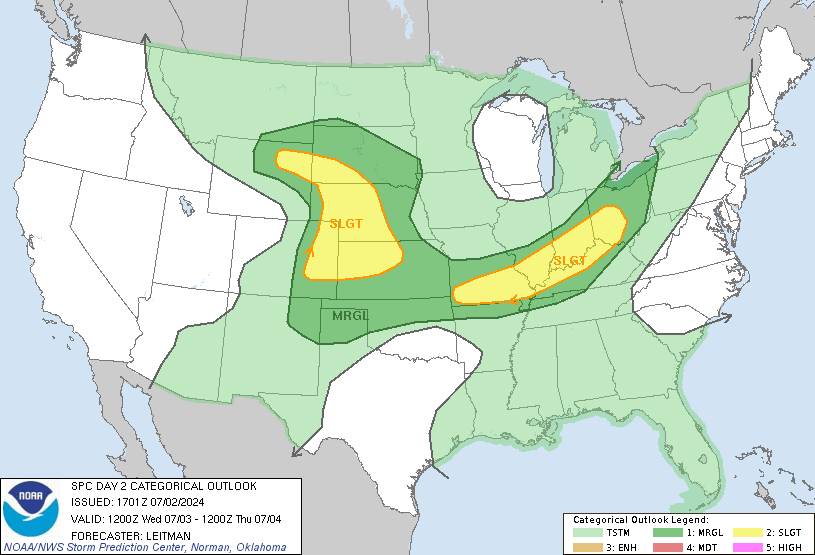
Good Monday afternoon everyone. I wanted to drop by for a quick update on the threat for severe thunderstorms for Tuesday as conditions are coming together for a possible big severe weather outbreak across our region. A powerhouse low pressure will develop across the plains and spin into the upper midwest. This will drag a cold front into the state later Tuesday and this front will have a line of damaging thunderstorm producing winds with it.
The dynamics with this system are very impressive and will be the dominating factor in producing severe weather over a large swath of real estate from the Great Lakes to the gulf states. The Storm Prediction Center has much of the state in a moderate risk for severe storms…

Here are the overall probabilities for severe storms…

Some quick points about all this…
– Winds ahead of the storms tomorrow will be very gusty and may top 40mph across the entire state.
– The line of storms will move quickly from west to east during the late afternoon and early evening hours.
– Widespread wind damage is possible with this line as 60-70mph winds are may occur.
– Isolated tornadoes will also be possible… especially for any cell that gets out on its own for a bit.
This is a potentially dangerous situation taking shape for Tuesday so please check back for later updates. As always… the blog will be here delivering the latest storm tracking information.
Take care.
Finally……….A front that isn’t passing silently!
I wondered to myself if it would take something major to change the weeks of hot dry nothingness…….I guess we will see tomorrow.
Oh goodness. Thanks for the heads up Chris. Forty miles per hour winds can really blow things around let alone the higher winds with the storms. I live on top of a hill and can really feel the effects of the winds. I’ll be out securing things this evening.
The NWS has gone with the SEVERE THUNDERSTORM forecast for tomorrow!!!!! At least for lawrenceburg.
well we got over a inch of rain in part of of manchester, well needed and brought more leaves off.
had a high of 71 late thisd afternoon. agree north and north west ky need to look out tomm.
the first song of the day this season, SUNDAY MORNING CHURCH by Alan Jackson.
well a guy that is crazy alot ole HENRY at ACCUweather has us in mostly a rainy winter with some mix.
I tend to agree this winter as a whole will be warm and not much snow, maybe a sneakl attack for 2-3 dayw with colder snaps and clippers but thats bout it.
biggest snow for SE EASTERN KY 6 inches or less. there will be a chance at a old school storm IMO in feburary and march but I think we will be on the edge as always the last decade.
So, if I’m reading this right, the kiddo’s should all be safely home before this rumbles through?
.12 inches today in Poplar Plains…..
i would say it depends on where you live
The Severe wording is standard procedure when SPC issues Moderate Risk.
Ahhhhh, I didn’t know that. Thats for that info. 🙂
Remember the Evansville tornado from 2005? NWS PAH says the parameters remind them of that event somewhat. I was camped out 5 miles from that tornado and it was scary I can assure you. Tomorrow is going to be a busy day.
remember all you weather buffs please join http://www.spotterchat.org for alot of good realtime info. great weather chat
The forecast pressure will bottom at 959mb with this system, which would sustain a cat 3-4 hurricane. Second lowest non tropical low pressure if it indeed reaches 959mb. WOW! I feel a hookie day coming tomorrow.
Finally got power back after last weeks storm. It was a bear not having air conditioning for the 4 days we didn’t have power. I think this is the first time I remember needing an air conditioner this close to November.